ATLAS of ANTIENT GEOGRAPHY by SAMUEL BUTLER 1843John McInnis Auctioneers,LLC4.6(502)See Sold PriceFeb 24, 2024
18TH C. ANTIQUE MAP: FRENCH & INDIAN WAR, FRAMEDThomaston Place Auction Galleries4.4(386)See Sold PriceFeb 24, 2024
Rand McNally Railroad Map Cabinet w/ 21 Railroad MapsRail & Road Auctions4.6(165)See Sold PriceMar 08, 2024
Keith Haring - Ink on New York Map, Best Buddies, Inscribed, Signed, and DatedSapphire Auction Gallery4(67)See Sold PriceMar 02, 2024
LATE 17TH C. FRENCH MAP OF THE NEW WORLD BY ALEXIS-HUBERT JAILLOT (1632-1712)Thomaston Place Auction Galleries4.4(386)See Sold PriceFeb 24, 2024
Central Railroad of New Jersey Map of Sandy Hook Route-ca. 1903JM Hobby Supply and Railroad Artifact Auctions4.4(126)See Sold PriceFeb 24, 2024
Lot of Six Mixed Atlas Box Cars-HO Scale-New in BoxJM Hobby Supply and Railroad Artifact Auctions4.4(126)See Sold PriceFeb 25, 2024
Rand McNally/Santa Fe Railroad Map of Iowa-1912JM Hobby Supply and Railroad Artifact Auctions4.4(126)See Sold PriceFeb 24, 2024
NICOLAES VISSCHER (NETHERLANDS, 1618-1709) MAP OF THE NEW WORLDThomaston Place Auction Galleries4.4(386)See Sold PriceFeb 24, 2024
17TH C. WORLD MAP BY NICOLAES VISSCHER (NETHERLANDS, 1618-1709)Thomaston Place Auction Galleries4.4(386)See Sold PriceFeb 24, 2024
Lot of Six Mixed Atlas Cabooses-HO Scale-New in BoxJM Hobby Supply and Railroad Artifact Auctions4.4(126)See Sold PriceFeb 25, 2024
SoldThe World On Mercator's Projection, 1829Map: The World On Mercator's Projection Maker: Anthony Finley Date: 1829 Size: Quarto, 8.9 inches high x 11.10 inches wide Details the world centered on the Pacific Ocean. Shows continents, countries,See Sold Price
The World On A Global ProjectionThe World On A Global Projection Hand Colored Map. Mercator Western and Eastern Hemisphere Cartographer: E. Huntington Publisher D. J. Robinson Dated:See Sold Price
SoldMitchell: Antique Map of the World; Mercator ProjectionTitle: Map of the World on the Mercator Projection Maker: Samuel A. Mitchell Date: 1867 Dimensions (inches): 23 x 15 Medium: Hand Colored Lithograph Condition: Great Condition Samuel Augustus MitchellSee Sold Price
Sold(2) ENGRAVED MAPS ASIA & WORLD MERCATOR PROJECTION(lot of 2) Framed engravings on paper, maps, including: (1) "General Chart on Mercator's Projection," engraved for Payn's [Payne's] "Universal Geography," published by Low & Willis, New York, sight: 7See Sold Price
Bonne: Antique Map of the World, Mercator's ProjectionTitle/Content of Map: 'Planisphere suivant la Projection de Mercator' A map of the world on Mercator's projection, showing the trade winds Date Printed: 1780 Image Size: Approx 23.0 x 35.0cm, 9 x 13.7See Sold Price
AARON ARROWSMITH - WORLD MERCATOR'S PROJECTION, 1812Aaron Arrowsmith - World Mercator's Projection, 1812 - 40 X 27 3/4 In. - Giclée On Canvas - Museum Wrapped - Large Piece Of Art - This Piece Is Ready To Hang On Your WallSee Sold Price
AARON ARROWSMITH - WORLD MERCATOR'S PROJECTION, 1812Aaron Arrowsmith - World Mercator's Projection, 1812 - 40 X 27 3/4 In. - Giclée On Canvas - Museum Wrapped - Large Piece Of Art - This Piece Is Ready To Hang On Your WallSee Sold Price
AARON ARROWSMITH - WORLD MERCATOR'S PROJECTION, 1812Aaron Arrowsmith - World Mercator's Projection, 1812 - 44 X 30 1/2 In. - Giclée Print - Gallery Stretched - Ready to hang.See Sold Price
AARON ARROWSMITH - WORLD MERCATOR'S PROJECTION, 1812Aaron Arrowsmith - World Mercator's Projection, 1812 - 40 X 27 3/4 In. - This Giclée Print Is Gallery Stretched And Ready To Hang Or Lean Against A Wall, Or Display On An Easel. - A Giclée Print IsSee Sold Price
Aaron Arrowsmith - World Mercator's Projection, 1812Aaron Arrowsmith - World Mercator's Projection, 1812 - 40 X 27 3/4 In. - Giclée On Canvas - Museum Wrapped - Large Piece Of Art - This Piece Is Ready To Hang On Your WallSee Sold Price
AARON ARROWSMITH - WORLD MERCATOR'S PROJECTION, 1812Aaron Arrowsmith - World Mercator's Projection, 1812 - 40 X 27 3/4 In. - Giclée On Canvas - Museum Wrapped - Large Piece Of Art - This Piece Is Ready To Hang On Your WallSee Sold Price
AARON ARROWSMITH - WORLD MERCATOR'S PROJECTION, 1812Aaron Arrowsmith - World Mercator's Projection, 1812 - 40 X 27 3/4 In. - Giclée On Canvas - Museum Wrapped - Large Piece Of Art - This Piece Is Ready To Hang On Your WallSee Sold Price
AARON ARROWSMITH - WORLD MERCATOR'S PROJECTION, 1812Aaron Arrowsmith - World Mercator's Projection, 1812 - 44 X 30 1/2 In. - This Giclée Print Is Gallery Stretched And Ready To Hang Or Lean Against A Wall, Or Display On An Easel. - A Giclée Print IsSee Sold Price
AARON ARROWSMITH - WORLD MERCATOR'S PROJECTION, 1812Aaron Arrowsmith - World Mercator's Projection, 1812 - 36 X 25 In. - This Giclée Print Is Gallery Stretched And Ready To Hang Or Lean Against A Wall, Or Display On An Easel. - A Giclée Print Is TheSee Sold Price
AARON ARROWSMITH - WORLD MERCATOR'S PROJECTION, 1812Aaron Arrowsmith - World Mercator's Projection, 1812 - 44 X 30 1/2 In. - This Giclée Print Is Gallery Stretched And Ready To Hang Or Lean Against A Wall, Or Display On An Easel. - A Giclée Print IsSee Sold Price
AARON ARROWSMITH - WORLD MERCATOR'S PROJECTION, 1812Aaron Arrowsmith - World Mercator's Projection, 1812 - 16 X 11 1/8 In. - This Giclée Print Is Gallery Stretched And Ready To Hang Or Lean Against A Wall, Or Display On An Easel. - A Giclée Print IsSee Sold Price
AARON ARROWSMITH - WORLD MERCATOR'S PROJECTION, 1812Aaron Arrowsmith - World Mercator's Projection, 1812 - 44 X 30 1/2 In. - Gallery Stretched The Piece Of Art Is Ready To Hang Or Lean Against A Wall, Or Display On An Easel. - A Giclée Print Is The HiSee Sold Price
AARON ARROWSMITH - WORLD MERCATOR'S PROJECTION, 1Aaron Arrowsmith - World Mercator'S Projection, 1812 - Giclée On Canvas - 44 X 30 1/2 In. A Giclée Print Is The Highest Quality Print Available Today. Because There Is No Visible Dot Screen Pattern,See Sold Price
SoldMap of World / Mercators Projection, 1868Original engraving from Johnson's Atlas of the World, 1868. Map includes vignette of Long Island & cities, towns and territories. Dimensions: 18" x 26". Shipping Domestic: Shipping rates are determindSee Sold Price
SoldCOLTON'S MAP OF THE WORLD - MERCATOR'S PROJECTION173. [COLTON'S MAP OF THE WORLD] Attractive map from the first Colton's Atlas of the World depicting what is now Alaska as Russian America with an undefined Antarctic and continents outlined in variouSee Sold Price
Map of World / Mercators Projection, 1868Original engraving from Johnson's Atlas of the World, 1868. Map includes vignette of Long Island & cities, towns and territories. Dimensions: 18" x 26". No Reserve Buyer pays shipping. This item shipsSee Sold Price
Map of World / Mercators Projection, 1868Original engraving from Johnson's Atlas of the World, 1868. Map includes vignette of Long Island & cities, towns and territories. Dimensions: 18" x 26". No Reserve Buyer pays shipping - ships from OceSee Sold Price
Map of World / Mercators Projection, 1868Original engraving from Johnson's Atlas of the World, 1868. Map includes vignette of Long Island & cities, towns and territories. Dimensions: 18" x 26". No Reserve This item ships from Ocean View, DE.See Sold Price
Map of World / Mercators Projection, 1868Original engraving from Johnson's Atlas of the World, 1868. Map includes vignette of Long Island & cities, towns and territories. Dimensions: 18 x 26 inches.See Sold Price
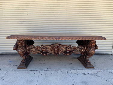
Hand-Carved Table by Valentino Panciera Besarel (Astragal 1829 - Venezia 1902)Cain Modern Auctions4.4(44)See Sold PriceFeb 28, 2024
Arrowsmith & Lewis - Map of the World on Mercator's ProjectionTrillium Antique Prints & Rare Books4.5(30)See Sold PriceFeb 24, 2024
Carey, pub. 1796 - A Chart of the West IndiesTrillium Antique Prints & Rare Books4.5(30)See Sold PriceFeb 24, 2024
Carey, pub. 1796 - Map of the State of MarylandTrillium Antique Prints & Rare Books4.5(30)See Sold PriceFeb 24, 2024
Carey, pub. 1796 - Map of GeorgiaTrillium Antique Prints & Rare Books4.5(30)See Sold PriceFeb 24, 2024
Carey, pub. 1796 - Map of The State of South CarolinaTrillium Antique Prints & Rare Books4.5(30)See Sold PriceFeb 24, 2024
Carey, pub. 1796 - Map of KentuckyTrillium Antique Prints & Rare Books4.5(30)See Sold PriceFeb 24, 2024
Carey, pub. 1796 - Map of the Tennassee State formerly part of North Carolina (Tennessee)Trillium Antique Prints & Rare Books4.5(30)See Sold PriceFeb 24, 2024
De Jode, Rare, pub. 1593 - Map of Africa (Africae Vera Forma, et Situs)Trillium Antique Prints & Rare Books4.5(30)See Sold PriceFeb 24, 2024
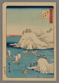
Ando Hiroshige II Woodblock - Muro Harbor in HarimaFloating World Auctions4.7(233)See Sold PriceMar 01, 2024
Blackie (Pub) 1882 Folio Map. World on Mercators ProjectionAlbion Auctions4.6(336)See Sold PriceMar 01, 2024