ATLAS of ANTIENT GEOGRAPHY by SAMUEL BUTLER 1843John McInnis Auctioneers,LLC4.6(502)See Sold PriceFeb 24, 2024
18TH C. ANTIQUE MAP: FRENCH & INDIAN WAR, FRAMEDThomaston Place Auction Galleries4.4(386)See Sold PriceFeb 24, 2024
Rand McNally Railroad Map Cabinet w/ 21 Railroad MapsRail & Road Auctions4.6(165)See Sold PriceMar 08, 2024
Keith Haring - Ink on New York Map, Best Buddies, Inscribed, Signed, and DatedSapphire Auction Gallery4(67)See Sold PriceMar 02, 2024
LATE 17TH C. FRENCH MAP OF THE NEW WORLD BY ALEXIS-HUBERT JAILLOT (1632-1712)Thomaston Place Auction Galleries4.4(386)See Sold PriceFeb 24, 2024
Central Railroad of New Jersey Map of Sandy Hook Route-ca. 1903JM Hobby Supply and Railroad Artifact Auctions4.4(126)See Sold PriceFeb 24, 2024
Lot of Six Mixed Atlas Box Cars-HO Scale-New in BoxJM Hobby Supply and Railroad Artifact Auctions4.4(126)See Sold PriceFeb 25, 2024
Rand McNally/Santa Fe Railroad Map of Iowa-1912JM Hobby Supply and Railroad Artifact Auctions4.4(126)See Sold PriceFeb 24, 2024
NICOLAES VISSCHER (NETHERLANDS, 1618-1709) MAP OF THE NEW WORLDThomaston Place Auction Galleries4.4(386)See Sold PriceFeb 24, 2024
17TH C. WORLD MAP BY NICOLAES VISSCHER (NETHERLANDS, 1618-1709)Thomaston Place Auction Galleries4.4(386)See Sold PriceFeb 24, 2024
Lot of Six Mixed Atlas Cabooses-HO Scale-New in BoxJM Hobby Supply and Railroad Artifact Auctions4.4(126)See Sold PriceFeb 25, 2024
SoldThe north part of North America 1825Heading: Author: Vivien de St. Martin, Louis Title: Carte de la partie Septentrionale du Nouveau Monde; ou sont Comprises Les Possessions Anglaises de l'Amerique du Nord. l'Amerique Russe et les RegiSee Sold Price
Sold'Travels Through Interior Parts' North America by J.'Travels Through Interior Parts' North America by J. Carver- London 1781- illustrated (some maps missing, cover as seen) & a leather bound 1802 pocket edition (as is)See Sold Price
Sold“Northpart of America” 1979 Signed & Ltd EdSigned by authors, Coolie Verner & Basil Stuart-Stubbs, on the information page. Published by Academic Press Canada, Toronto. #1441 of 1500 copies. 292pp. Oblong folio. Illustrated. Early cartographySee Sold Price
SoldThe Northpart of America 1/1500 copiesHeading: Author: Verner, Coolie & Basil Stuart-Stubbs. Title: The Northpart of America Place Published: [Toronto] Publisher:Academic Press Date Published: [1979] Description:See Sold Price
SoldVerner. THE NORTHPART OF AMERICA. One of 1500.[Reference] Coolie Verner and Basil Stuart-Stubbs. THE NORTHPART OF AMERICA. (Toronto): Academic Press, (1979). Folio. Beige cloth in slipcase. Near fine. One of 1500 signed by the authors.See Sold Price
The Northpart of America 1/1500 copiesTitle: The Northpart of America Author: Verner, Coolie & Basil Stuart-Stubbs. Description: With reproductions of 46 maps, some color. (Folio), cloth, slipcase. No. 443 of 1500 copies. First Edition.SiSee Sold Price
The Northpart of AmericaAuthor: Verner, Coole and Basil Stuart-Stubbs Description: [10], 292 pp. Illustrated throughout with reproductions of old maps. 13¼x15¾, gilt-decorated linen, linen slipcase. No. 1248 of 1500 copiesSee Sold Price
SoldThe Northpart of America 1/1500 copiesHeading: Author: Verner, Coolie & Basil Stuart-Stubbs Title: The Northpart of America Place Published: [Toronto] Publisher:Academic Press Date Published: [1979] Description: WitSee Sold Price
The Northpart of America 1/1500 copiesHeading: Author: Verner, Coolie & Basil Stuart-Stubbs Title: The Northpart of America Place Published: [Toronto] Publisher:Academic Press Date Published: [1979] Description:See Sold Price
The Northpart of AmericaTitle: The Northpart of America Author: Verner, Coolie & Basil Stuart-Stubbs. Description: With reproductions of 46 maps, some color. (Folio), cloth, slipcase. One of 1500 copies. First Edition.SignedSee Sold Price
SoldJOHN SENEX (ENGLISH, 1678-1740), MAP OF NORTH AMERICAJOHN SENEX (ENGLISH, 1678-1740), MAP OF NORTH AMERICA, hand-colored, on laid paper, title in cartouche in upper left corner, lettered in part "NORTH / AMERICA / CORRECTED FROM THE OBSERVATIONS / COMMUSee Sold Price
SoldCoolie Berner And Basil Stuart-Stubbs THE NORTHPART OFCoolie Berner And Basil Stuart-Stubbs THE NORTHPART OF AMERICA 1979 Author-Signed Limited First Edition Scarce Excellent Condition Slipcase Decorative Cloth And Gilt Binding Oversized Maps North AmeriSee Sold Price
SoldCoolie Berner And Basil Stuart-Stubbs THE NORTHPART OFCoolie Berner And Basil Stuart-Stubbs THE NORTHPART OF AMERICA 1979 Author-Signed Limited First Edition Scarce Slipcase Decorative Cloth And Gilt Binding Maps North America 1556-1875 History Canada PaSee Sold Price
SoldMAP, C. 1760, "PART OF NORTH AMERICA" VAUGONDYFramed map, c. 1760, "Part of North America comprehending The Course of the Ohio, New England, New York, New Jersey, Pennsylvania, Maryland, Virginia, Carolina and Georgia from the Sr. Robert, with ImSee Sold Price
EARLY MAP OF "PART OF NORTH AMERICA COMPREHENDINGEARLY MAP OF "PART OF NORTH AMERICA COMPREHENDING THE COURSE OF THE OHIO". Hand colored engraving on laid paper with good color. Also New England, New York, New Jersey, Pennsylvania, Maryland, and VirSee Sold Price
Sold(CANADA.) Part of North America containing Can(CANADA.) Part of North America containing Canada, the North Parts of New England and New York. Engraved map, 210x300 mm, ample margins; hand-colored in outline; few nicks along bottom edge. Np, circaSee Sold Price
Sold"Map of Part of North America" (incl. Maryland) Rigober"Map of Part of North America," Rigobert Bonne, 1780, hand-colored map of the Northeastern American coast from Maine to Virginia, including Maryland. Framed and matted. Excellent condition. Framed DimSee Sold Price
SoldBriggs North Part of AmericaBriggs, Henry (1561-1630). The North Part of America... Engraved map. London: William Stanley for Henrie Featherstone: 1625. 12 1/2" x 14 1/4" sheet, 21 3/4" x 23 1/2" framed. The first map to show CaSee Sold Price
SoldBriggs' Engraved Map of North Part of AmericaThe North Part of America. Henry Briggs (1561-1631). Engraved map. London: W. Stanley for H. Featherstone, 1625. 12 1/4 x 14 inches sheet, 21 3/4 x 23 3/4 inches framed. The first map to depict CalifoSee Sold Price
SoldBriggs The North Part of America 1625The North Part of America Conteyning Newfoundland, new England, Virginia, Florida, new Spaine, and Nova Francia,...Henry Briggs (1561-1631). London: William Stanley for Henrie Featherstone, 1625-1626.See Sold Price
Travels Through The Interior Parts of North-AmericaTravels through the Interior Parts of North-America, in the Years 1766, 1767, and 1768. Place Published: Dublin Publisher: S. Price Date Published: 1779 Edition: 1st Binding: Hard Cover First Irish EdSee Sold Price
SoldTravels through the Interior Parts of North America, inCarver, Jonathan (1710-1780). Travels Through the Interior Parts of North America, in the Years 1766, 1767, and 1768. By J. Carver, Captain of a Company of Provincial Troops During the Late War with FSee Sold Price
SoldMOLL. A New Map of the North Parts of America claMAP - MOLL, Herman. A New Map of the North Parts of America claimed by France.London: printed for H. Moll, 1720. Engraved map (sheet size: 648x1045 mm.), hand-colored in outline, with small oSee Sold Price
MOLL. A New Map of the North Parts of America....Cartographic Propaganda—French Pretensions in North America Refuted California as an Island 344. &nbsSee Sold Price
8" x 8" A+ Male Monarch Butterfly - Danaus PlexippusWeatherham Estate Treasures3.9(157)See Sold PriceMar 07, 2024
8" x 8" Female Monarch Butterfly - Danaus Plexippus (Ventral Side)Weatherham Estate Treasures3.9(157)See Sold PriceMar 07, 2024
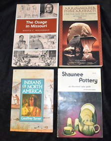
4 Books about Indians and Indian Artifacts Softbacks in very good to near new conditionNorth American Artifact Auctions4.6(182)See Sold PriceApr 20, 2024
5 Hardback Books on Birds, Animals & Nature all in Excellent condition.North American Artifact Auctions4.6(182)See Sold PriceApr 20, 2024
Audubon's Animals - The Quadrupeds of North America 1954 Folio Size BookNorth American Artifact Auctions4.6(182)See Sold PriceApr 20, 2024
A Field Guide To Wildflowers, Birds & Birds Nesting 3 Books from the Peterson Field Guide SeriesNorth American Artifact Auctions4.6(182)See Sold PriceApr 20, 2024
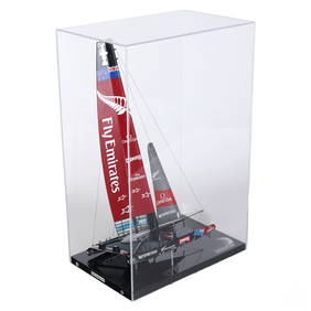
Abordage Official Emirates Team NZ Ship Desk ModelHill Auction Gallery 4.7(1k)See Sold PriceFeb 28, 2024
Carey, pub. 1796 - Map of the Tennassee State formerly part of North Carolina (Tennessee)Trillium Antique Prints & Rare Books4.5(30)See Sold PriceFeb 24, 2024
Audubon, Imperial Folio - 4 Lithographs of Squirrel, Rat, MiceTrillium Antique Prints & Rare Books4.5(30)See Sold PriceFeb 24, 2024
Audubon, Imperial Folio - American Cross Fox. 6Trillium Antique Prints & Rare Books4.5(30)See Sold PriceFeb 24, 2024
Audubon, Imperial Folio - Canada Lynx. 16Trillium Antique Prints & Rare Books4.5(30)See Sold PriceFeb 24, 2024
Map: A 19thC engraved map of West Riding, titled A Map of the North Part of the West Riding ofClaydon Auctioneers Ltd4.3(125)See Sold PriceFeb 26, 2024
NORTH AFRICA BARBARY. Parts of Tripoli (Libya) & Egypt. Tribes. SDUK 1844 mapJasper524.5(9.8k)See Sold PriceFeb 28, 2024
NORTH AFRICA BARBARY. Parts of Tripoli (Libya) & Egypt. Tribes. SDUK 1844 mapJasper524.5(9.8k)See Sold PriceFeb 28, 2024
NORTH AFRICA BARBARY. Parts of Tripoli (Libya) & Egypt. Tribes. SDUK 1848 mapJasper524.5(9.8k)See Sold PriceFeb 28, 2024
Herman Moll A New Map of Ye North Parts of AmericaWillow Auction House4.5(283)See Sold PriceMar 14, 2024