MATTHEWS c1856 Map Of Upper Canada Ontario Indian Land Agency Divisions Scarce!Luis Porretta Fine Arts4.3(10)See Sold PriceMar 02, 2024
DEVINE c1856 Dr Salters Map Of Lake Huron Ontario Indian Lands etc. No. 7 ScarceLuis Porretta Fine Arts4.3(10)See Sold PriceMar 02, 2024
DUNLEVIE c1856 Map Counties Of Gaspe & Bonaventure Quebec Canada SCARCE! #1Luis Porretta Fine Arts4.3(10)See Sold PriceMar 02, 2024
DUNLEVIE c1856 Map Counties Of Gaspe & Bonaventure Quebec Canada SCARCE! #2Luis Porretta Fine Arts4.3(10)See Sold PriceMar 02, 2024
Map UNITED COUNTIES LEEDS & GRENVILLE by Walling 1861 Rare Canada Map 5ft x 5ftLuis Porretta Fine Arts4.3(10)See Sold PriceMar 02, 2024
Ambroise TARDIEU c1822 Map Venice Napoleon Italian Campaign 17" x 11"Luis Porretta Fine Arts4.3(10)See Sold PriceMar 02, 2024
SoldTHE MOOSE BOOK W/ Map Samuel Merrill, 1918THE MOOSE BOOK FACTS and STORIES from NORTHERN FORESTS by Samuel Morris, 1916. First Edition. Bound and profusely illustrated volume, covers the entire sport of moose hunting. Both the American mooseSee Sold Price
Sold3 vols. Sporting & Natural History - Fau3 vols. Sporting & Natural History - Fauna: Merrill, Samuel. The Moose Book. New York: Dutton, (1916). Lg. 8vo, orig. pictorial green cloth, gilt; light wear. Plates, text illus., fold. map. * KeartonSee Sold Price
SoldConant family, W. Cornwall, VT books & 1867 DC journalincluding 1841 Atlas of Ancient Geography w/ hand colored maps signed Samuel M Conant Middlebury CollegeSee Sold Price
SoldThe Moose Book by Merrill (2) 1ST and 2ND EDTwo editions, first and second of the Moose Book by Samuel Merrill. Both published by E. P. Dutton and Co., New York. 1916 first edition, 366 pp. Illustrated. Green cloth with gilt lettering and desigSee Sold Price
SoldHUNTING.HUNTING. Group of 16 volumes, as listed below. "Brasher, Rex. Secrets of the Friendly Woods. 1926" * "Merrill, Samuel. The Moose Book. 1916" * "Woodcock, E.N. Fifty Years a Hunter and Trapper. 1941" *See Sold Price
Sold19th c VT books, registers, imprints19th c VT books, registers, & imprints, including Hemenway, Windham Co w/ map,See Sold Price
SoldEmmons. Geological Guide BookEmmons, Samuel Franklin. Geological Guide Book for an Excursion to the Rocky Mountains. NY: 1894. 4 TO. 480 pp. Illus. w/map & engravings (binding poor). Together with: Lindgren, Waldemar. The GeologySee Sold Price
SoldThe Moose Book on Moose HuntingMerrill. The Moose Book. Facts and Stories from Northern Forest. NY: E. P. Dutton. 2nd edition, revised and updated. Folding map. Light wear to spine ends and tips.See Sold Price
SoldVermont books, ledgers, mapsVermont books, ledgers, books with maps including Beers Franklin & Grand Isle Co, Hemenway Vol II, Thompson's VT w/ map, Childs Franklin & GI Co w/ map, etcSee Sold Price
SoldThree Books by Ring LardnerLardner, Ring W. My Four Weeks in France. Indianapolis: Bobbs-Merrill, [1918]. Lettering gone on spine; spine cloth darkened AND The Love Nest and Other Stories. NY: Scribner's, 1926. 1st. Spine giltSee Sold Price
Sold19th c Books, Maps, and PrintsCa 1852 Samuel Goodrich "Peter Parley's Cabinet Library" (17 vols), leather, 6 3/4" x 4 1/4", sold with 1896 MacDowell Woodland Sketches as well as two Handcolored 19th c Lithographs, two 1902 NationaSee Sold Price
Sold8 Early Vermont history books by Zaddock Thompson8 Early Vermont history books by Zaddock Thompson including 5 copies of the History of Vermont Natural, Civil, and Statistical published by Chauncey & Goodrich Burlington, VT 1842 (4 w/maps, as found)See Sold Price
FRAMED MAP, ENGLAND & WALES, SAMUEL LEWIS, C. 1849Framed "Map of England & Wales", Topographical Dictionary, Samuel Lewis & Co., London, c. 1849, lightly hand colored, book folds, sight: 19"h, 15.75"w, overall: 26"h, 22"w, 5.5lbs Start Price: $80.00See Sold Price
On Two Frontiers, Geo. T. Buffum, 1st thusTrue-life stories about the Old West told by one who knew many of the participants. Illust. by Frank Merrill. Pub. 1918 by Lothrop, Lee & Shepard. Clean, sound binding, w/rubbing at tips and spine endSee Sold Price
Sold1712 Works of Petronius Arbiter1712 Works of Petronius Arbiter, printed for Samuel Briscoe, London leather bound book, illus w/ several platesSee Sold Price
SoldBaltimore Topographical Map Atlas Book, 1918large cloth bound volume with large linen backed fold out topographical maps of Baltimore City, 36 in. H., 22 in. W.See Sold Price
Soldlot of 18th and early 19th c. leather bound booksincl. 1784 Belkap's History of NH in 3 vols. w/fold out map (as is), 1833 Burlington printed Zaddock Thompson's History of VT, partial 1733 series of The Spectator London, American Antiquities, etc. 1See Sold Price
Sold5 RARE H/C MANUSCRIPT/ACTUAL SURVEY MAP STOCKPORT NYLOT (5) RARE H/C MANUSCRIPT ACTUAL SURVEY MAP STOCKPORT NY W/ SECTION, BLOCK & LOT NAMED INCL. DELAWARE RIVER; ROAD TO FORT PENN, 18TH C. 19" X 24" W/ MANUSCRIPT LETTER TO SAMUEL PRESTON AUTHORIZING ASee Sold Price
SoldEARLY MANUSCRIPT MAPS ACTUAL SURVEYSH/P LOT (3) EARLY MANUSCRIPT MAPS ACTUAL SURVEYS W/ SECTION LOT/PLOT SIGNED SAMUEL PRESTON-WM. SIMPSON, C. 1791, LARGEST 10" X 16"See Sold Price
Sold3 books incl: Santo Domingo, Past And Present...[Caribbean] 3 Titles. ++ Samuel Hazard. Santo Domingo, Past And Present: With A Glance At Hayti. NY: Harper & Brothers, 1873. Folding map, many illustrations. ++ E. W. Gilliam. 1791: A Tale Of San DomSee Sold Price
Sold1795 map of the State of New Jersey1795 map "The State of New Jersey" from Mathew Carey's American Atlas, compiled by Samuel Lewis, engraved by W Baker, two sheet, original outline hand coloring, some staining, 21 1/2" x 17"See Sold Price
SoldRARE H/C MANUSCRIPT ACTUAL SURVEY MAP STOCKPORTLOT (2) RARE H/C MANUSCRIPT ACTUAL SURVEY MAP STOCKPORT FOR JACOB DOWNING/WM.DRINKER W/ SECTION, BLOCK & LOT W/ PROPERTY OWNERS INCL. ROAD FROM STANTONVILLE TO STOCKPORT AND SAMUEL PRESTON'S PROPERTY,See Sold Price
SoldAntique Book of Maps & Geography by Jedidiah MorseAntique Book of Maps & Geography by Jedidiah Morse, Father of Artist and Inventor Samuel F B Morse. Printed in the 1790's. Measures 10"h x 6" w.See Sold Price
Occupied Japan Lacquer Book Cover w. chip-carved map/Japan on back Buddha on FrontThe Buddha Gallery4.4(29)See Sold PriceMar 13, 2024
WILLASEY-WILSEY Outline History 8th Gurkha Rifles 1945 VG Book w Dust WrapperLuis Porretta Fine Arts4.3(10)See Sold PriceMar 02, 2024
Early Pennsylvania Railroad Literature - 1881 New York and Chicago Limited Timetable Brochure andRail & Road Auctions4.6(165)See Sold PriceMar 07, 2024
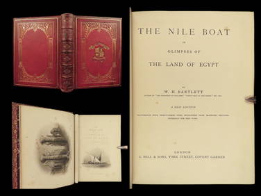
1880 Niles Boat Egypt Voyages Sphinx Pyramids Valley of Kings Illustrated MAPSSchilb Antiquarian Rare Books4.8(415)See Sold PriceMar 31, 2024
The Columbian World's Fair Atlas 1892 / 1918 WW I Scrap Book Christian Herald Paper Clips Glued InNorth American Artifact Auctions4.7(175)See Sold PriceApr 20, 2024
FORT LARAMIE NATIONAL MONUMENT, WYOMING 1954North American Artifact Auctions4.7(175)See Sold PriceApr 20, 2024
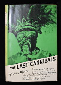
THE LAST CANNIBALS by JENS BJERRE 1957 Fine or Near FineNorth American Artifact Auctions4.7(175)See Sold PriceApr 20, 2024
Arrowsmith & Lewis - Map of the United StatesTrillium Antique Prints & Rare Books4.5(28)See Sold PriceFeb 24, 2024
1855 NOTES ON CENTRAL AMERICA by E. G. Squier antique w/ MAPSJasper524.5(9.7k)See Sold PriceFeb 27, 2024
1738 BIBLE in DUTCH ILLUSTRATED w/ MAPS MASSIVE FOLIO in DUTCH antique BIBLIAJasper524.5(9.7k)See Sold PriceFeb 27, 2024
1800 MUNGO PARK TRAVELS to AFRICA 2 VOLS w/ MAP antique in ENGLISHJasper524.5(9.7k)See Sold PriceFeb 27, 2024
1744 ROMAN HISTORY ARMORIAL VELLUM BINDING ILLUSTRATED w/ MAP antique by FLORUSJasper524.5(9.7k)See Sold PriceFeb 27, 2024
1729 GERMANIA SACRA by M. Hansiz BLINDSTAMPED PIGSKIN antique FOLIO w/ MAPJasper524.5(9.7k)See Sold PriceFeb 27, 2024
1749-1771 HISTORY OF ROMAN EMPERORS 12 VOLUMES antique ILLUSTRATED w/ MAPSJasper524.5(9.7k)See Sold PriceFeb 27, 2024
1675 ELZEVIER JULIUS CAESAR antique ILLUSTRATED w/ MAPS ROMAN HISTORYJasper524.5(9.7k)See Sold PriceFeb 27, 2024
1711 GREEK BIBLE ILLUSTRATED w/ MAPS VELLUM BOUND antique NEW TESTAMENTJasper524.5(9.7k)See Sold PriceFeb 27, 2024
1704 DESCRIPTION OF ALL THE SEATS OF THE PRESENT WARS OF EUROPE antique w/ MAPSJasper524.5(9.7k)See Sold PriceFeb 27, 2024
1738 BIBLE in DUTCH ILLUSTRATED w/ MAPS antique MASSIVE FOLIO BIBLIAJasper524.5(9.7k)See Sold PriceFeb 27, 2024
1709 GREEK BIBLE ILLUSTRATED w/ MAPS antique VELLUM BOUND Septuagint editionJasper524.5(9.7k)See Sold PriceFeb 27, 2024
CURTIUS RUFUS QUINTUS, SIXTEENTH-CENTURY ELZEVIER HISTORIARUM LIBRI W/ MAP 16.33NY Elizabeth 4.3(83)See Sold PriceMar 03, 2024