Soldca.1960 VINTAGE JAPAN TRAVEL GUIDE BOOK w FOLD OUT MAPca.1960 VINTAGE JAPAN TRAVEL GUIDE BOOK w FOLD OUT MAP by JAPAN AIRPORT TERMINAL ca.1960 VINTAGE JAPAN TRAVEL GUIDE BOOK w FOLD OUT MAP by JAPAN AIRPORT TERMINAL Circa 1960s Graphic Old Vintage TravelSee Sold Price
SoldAbsaraka Home of the Crows w/ Fold Out MapThis is a scarce edition of "Absaraka Home of the Crows" by Mrs. Margaret I. Carrington and published in 1950. The book was written by the wife of Colonel Henry B. Carrington who was the commander ofSee Sold Price
SoldBOUND BOOK W/ CELESTIAL/ASTROLOGICAL MAPS C.1835A bound book containing multiple celestial/astrological maps dates 1835. Ht: 16" Width: 14"See Sold Price
Short Papers & Reports / U.S.G.S. / 2 Items. #109683Item # 1 of 2: Bulletin # 430 / Contributions To Economic Geology / Part 1- Metals & Non Metals Excepts Fuels. ( 14 Plates w/ 12 fold out maps, 653 pages / 1910 ). Item # 2 of 2: Contributions To EconSee Sold Price
Sold9V ANTIQUE HISTORY Decorative Leatherbound Gilt9V ANTIQUE HISTORY Decorative Leatherbound Gilt History of England Thomas Babington Macaualay Complete Historic Towns London W J Loftie Fold‐Out Map Nouvelle Geographie Generale Maurice WahlSee Sold Price
NEW COLOURED PICTORIAL ATLAS of INDIA (cover title)Title/Content of Map: NEW COLOURED PICTORIAL ATLAS of INDIA (cover title) Date: 1943 Cartographer: SINGH, B Publisher: MAP HOUSE & INDIAN BOOK DEPOT Size: 14"W x 10.8"W Each map bears reading: "This mSee Sold Price
Sold[McMURTRY, Larry (1936-2021), his copy]. GRAVES, Robert (18...[McMURTRY, Larry (1936-2021), his copy]. GRAVES, Robert (1895-1985). Goodbye to a River. [Austin: W. Thomas Taylor for] The Book Club of California, 1989. 4to. Illustrated with foldout map and from phSee Sold Price
SoldA Year with the Turks by Warington W. SmythA Year with the Turks or Sketches of Travel by Warington W. Smyth, M. A. 1854. Redfield. Fold out map intact with tape at edge. Provenance: Estate of Russell Johanson, Ravenna Rare Books, Seattle, Wa.See Sold Price
SoldBellin: Antique Map Gulf of Mexico & West Indies, 1754Title/Content of Map: Carte du Golphe de Mexique et des Isles de l'Amerique Cartographer: Jacques Bellin Place & Date: Paris / 1754/1760 Size: 14 3/4" x 10 3/4" Condition: b&w; old folds as published;See Sold Price
SoldBellin: Antique Map of Course of the Amazon, 1754Title/Content of Map: Carte du Cours du Maragnon ou de la Grande Riviere des Amazones Cartographer: Bellin Place & Date: Paris / 1754/1760 Size: 14 5/8" x 6 7/8" Condition: b&w; old folds; light overaSee Sold Price
Sold7V DECORATIVE ANTIQUE EUROPEAN TRAVEL Elaborate Gilt7V DECORATIVE ANTIQUE EUROPEAN TRAVEL Elaborate Gilt Illustrated Photographs Mediterranean D E Lorenz Fold‐Out Maps Genoa Virginia W Johnson Constantinople Turkey Clara Erskine Clement NapleSee Sold Price
SoldBaltimore Topographical Map Atlas Book, 1918large cloth bound volume with large linen backed fold out topographical maps of Baltimore City, 36 in. H., 22 in. W.See Sold Price
SoldGroup of Four Vintage American Pocket Maps[Maps] Group of Four Vintage American Pocket Maps. Chicago: Rand McNally, 1913 – 14. Including California, Alabama, Washington and Oregon. Brown paper wraps. Pictorial ads, fold out color maps.See Sold Price
SoldTHOMAS BOWEN MAP OF THE WORLD 1778A Mercator Chart of the World by Thomas Bowen. Later coloring. Dimensions: (Frame) H 21" x W 25", (Sight) H 14" x W 18" Condition: With folds as issued.See Sold Price
Sold(3) OLD NEW YORK CITY MAPS, VALENTINE'S MANUALIncluding "Plan of the Central Park, city of New York, 1860." Hand colored Dimensions: (Largest) H 18.5" x W 14" Condition: Removed from books, folds, edge damages, toning.See Sold Price
SoldPABLO PICASSO VERVE FIRST EDITION 1948PABLO PICASSO VERVE FIRST EDITION 1948 H 14" W 10.5" PABLO PICASSO SPAIN (1881-1973) FIRST EDITION, PARIS "VERVE" BOOK 1948 H 14" W 10" :Pablo Picasso Couleur de Picasso: Antipolis 1946 in Verve, VoluSee Sold Price
SoldBook LotBook Lot: 3 Pcs. - early Road, Travel & Guides. Good lot; THE TOURIST'S ROUTE MAP OF ENGLAND AND WALES. 1885. Hard Cover bound with Fold Open LINEN BACKED SECTIONAL MAP. Published by THE BICYCLE & TRISee Sold Price
SoldJASPER JOHNS MAPS NUMBERS 2013 LITHOGRAPHOn vellum. Signed in plate lower right. Dimensions: (Frame) H 18.75" x W 14.75", (Sight) H 14.25" x W 10.5" Condition: Horizontal foldSee Sold Price
Sold1640 Spice Island MapA 1640 Spice Island Map. Hand colored engraving. Fold line in center (two pages out of a book, with text verso); staining/discoloration/toning, edge damage. Image is 19 1/4" x 14 1/2" high, the sheetSee Sold Price
Sold(3) OLD NEW YORK CITY MAPS, VALENTINE'S MANUALIncluding "Old New York, The Bouwery," 1862. Dimensions: (Largest) H 16.75'" x W 20.5" Conditions: Removed from books, folds, edge damages, toning.See Sold Price
Sold(7) OLD NEW YORK MAPS ETC, VALENTINE'S MANUALMiscellaneous views and maps of NYC and New York State published in Valentine's Manual. Dimensions: (Largest) H 18" x W 22.75" Condition: Removed from books, folds, tears, edge losses, toning.See Sold Price
ASIA Chinese Empire overprinted w/ Republic due to Emperor's abdication 1913 mapCAPTION PRINTED BELOW PICTURE: 'Asia' DATE PRINTED: 1913 IMAGE SIZE: Approx 35.5 x 43.0cm, 14 x 17 inches (Large); Please note that this is a folding map. TYPE: Antique colour atlas map; Scale 1: 27,2See Sold Price
SoldTALLIS, 1851 MAP OF NORTH AMERICAWith COA on verso. John Tallis, 1851. Hand colored engraving with central horizontal fold. Dimensions: (Frame) H 24.5" x W 20" (Sight) H 14" x 10.25" Condition: Flattened horizontal fold.See Sold Price
Archaeological Books - W. M. Flinders Petrie - Historical ScarabsTimeLine Auctions Ltd.4.5(183)See Sold PriceMar 06, 2024
Archaeological Books - Streeter - Gold: Legal Regulations for the Standard of Gold & Silver Wares inTimeLine Auctions Ltd.4.5(183)See Sold PriceMar 06, 2024
Archaeological Books - Streeter - Gold: Legal Regulations for the Standard of Gold & Silver Wares inTimeLine Auctions Ltd.4.5(183)See Sold PriceMar 06, 2024
Numismatic Books - Whelan - The Numismatic Atlas of the Roman EmpireTimeLine Auctions Ltd.4.5(183)See Sold PriceMar 09, 2024
Pair of Early Railroad Maps - 1874 Delaware, Lackawanna & Western and 1876 Pennsylvania RailroadRail & Road Auctions4.6(165)See Sold PriceMar 07, 2024
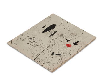
Joan Miro (1893-1983), "Trace sur l'eau," Original lithograph in colors on wove paper as wrap-aroundJohn Moran Auctioneers, Inc.4.7(453)See Sold PriceFeb 27, 2024
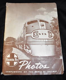
Sante Fe Photos Compliments of the Sante Fe Railway (60's-70's)North American Artifact Auctions4.6(182)See Sold PriceApr 20, 2024
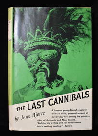
THE LAST CANNIBALS by JENS BJERRE 1957 Fine or Near FineNorth American Artifact Auctions4.6(182)See Sold PriceApr 20, 2024
Putnam - First Map of the State of Ohio by Rufus PutnamTrillium Antique Prints & Rare Books4.5(30)See Sold PriceFeb 24, 2024
1800 MUNGO PARK TRAVELS to AFRICA 2 VOLS w/ MAP antique in ENGLISHJasper524.5(9.8k)See Sold PriceFeb 27, 2024
1749 MAP CARTE DE LA TARTARIE ORIENTALE RUSSIA & CHINA antique EASTERN TARTARYJasper524.5(9.8k)See Sold PriceFeb 27, 2024
18th century MAP of ARMENIA GEORGIA NATOLIA BLACK SEA ASIA MINOR antiqueJasper524.5(9.8k)See Sold PriceFeb 27, 2024
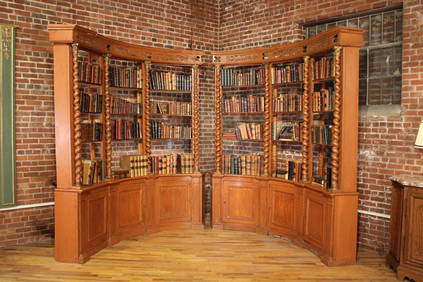
Pair of Handmade Plywood Minimalist Book or Record CabinetsPUBLIC SALE4.7(217)See Sold PriceMar 02, 2024
MAGHREB. North Africa Morocco Algeria & Tunisia. JOHNSTON 1913 old antique mapJasper524.5(9.8k)See Sold PriceFeb 28, 2024
ANTIQUE ILLUSTRATED HANDBOOK OF GEOGRAPHY AND TRAVEL IN ASIA, VOLUME 2, 1896NY Elizabeth 4.3(84)See Sold PriceMar 03, 2024
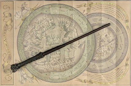
Universal Studios Harry Potter Wand BRapid Estate Liquidators and Auction Gallery4.5(1.1k)See Sold PriceFeb 28, 2024


![[McMURTRY, Larry (1936-2021), his copy]. GRAVES, Robert (18... (1 of 4)](https://p1.liveauctioneers.com/928/295567/157314291_1_x.jpg?height=282&quality=70&version=1689365279)