SoldThayer's Map of the Leadville MineLake County. By H. L. Thayer. Includes mines and placer mining claims. Also smelters. Includes Park City, Iron Hills, Adelaide, Carbonate Park, Breece Hill, etc. Map was at one time folded and folds aSee Sold Price
SoldThayer's map of Colorado, col. Denver: 1880Thayer, H.L. Thayer's map of Colorado, col. Denver: 1880Dimensions:24" X 27 1/4"Inv.144See Sold Price
SoldThayer's Map of New Mexico. Julius Bien 1880Thayer, H.L... Thayer's map of New Mexico. Denver: Author, NY: Julius Bien, lithograph and printer, 1880Dimensions 29" X 23 3/4"Note: Includes military reservations.Inv.145See Sold Price
SoldENSIGN & THAYER’S MAP OF THE WESTERN STATES. 1854.[United States/Midwest]. ENSIGN & THAYER’S MAP OF THE WESTERN STATES [Cover title]. Pocket map, with printed text. Map of the Western States by J. M. Atwood. 1854. 21 ½ x 27 inches (sheet size unfoSee Sold Price
SoldENSIGN & THAYER MAP OF THE WESTERN STATESENSIGN & THAYER, MAP OF THE WESTERN STATES, 19TH CENTURY:Ensigns & Thayer's Traveler's Guide through the States of Ohio, Michigan, Indiana, Illinois, Missouri, Iowa, and Wisconsin; with Railroad, CanaSee Sold Price
Sold1852 ENSIGN & THAYER MAP OF THE UNITED STATESMexico and the West Indies. 36 x 35 inches.See Sold Price
Sold(CALIFORNIA.) Stoll, Simon; and J.S. Thayer. Map of the(CALIFORNIA.) Stoll, Simon; and J.S. Thayer. Map of the Central Part of the City of Los Angeles California. Heliotype pocket map of Los Angeles with keyed reference tables. 22x22¾ inches overall,See Sold Price
SoldEnsign & Thayer Map of the United States, 1849 Ensign & Thayer Map of the United States, 1849 Mexico and the West Indies. 35.5 x 37 in. map on wood "roller" (max. length 40.5 in.), on cartographic linen and varnished as usual for the period; hanSee Sold Price
ENSIGN & THAYER. Map of the City of New York, with theENSIGN & THAYER. Map of the City of New York, with the adjacent cities of Brooklyn & Jersey City. New York, 1848. Engraved map hand-colored in outline, 432 x 532 mm sheet. Insets of Jersey City and UpSee Sold Price
Sold"Ensign & Thayer's Map of the Western States," 1848 21.5 x 27 in., hand-colored. Still folded in its 3.5 x 5.5 in. red "leatherette" covers with 33pp text (plus 2pp ads). Covers with wonderful gilt designs of a train with open cars and a riverboat (witSee Sold Price
Sold1849 Map of the Western States Ensign Thayer.1849 Map of the Western States Ensign Thayer. Ensign & Thayer's Map of the Western States. Pocket Map. 1849. 21 x 27". Hand-colored. Some tears and separations at folds. Complete. Includes west to NebSee Sold Price
SoldEnsign & Thayer's Western Map Book 1851 w/ Pa MapEnsign & Thayer's Map of the Western United States. Cover 5-1/2" x 3-1/2", brown leather/gilt with locomotive and riverboat. Cover page "Ensign & Thayer's Travellers Guide Through the States of Ohio,See Sold Price
SoldEnsign & Thayer Gold Regions MapEnsign & Thayer. Map of the Gold Regions of California. Showing the Routes via Chagres and Panama, Cape Horn &c. Lithographed map with original hand color. New York, 1849. 25 1/4" x 20 5/8" sheet, 36"See Sold Price
SoldThayer's 1853 Map of The United StatesHand colored lithograph laid on canvas by Horace Thayer & Co., NY, showing map surrounded by vignete scenes from American history. 43 1/4" x 30 1/2" with original ebonized wood hangers.See Sold Price
SoldAntique 1853 Hand Colored United States of America Pictorial Map Thayer Bridgman Fanning PublishersDescribed By:Michelle NODD HFA DBJQ Title:Antique 1853 Hand Colored United States of America Pictorial Map Thayer Bridgman Fanning Publishers Description: Antique 1853 Hand Colored United States of AmSee Sold Price
Sold1847 Ensigns & Thayer “Pictorial Map of the United1847 Ensigns & Thayer “Pictorial Map of the United States” (chips, minor losses, creases) 29.5” x 41” framedSee Sold Price
SoldMap of Leadville Colorado mines 1913Heading: (Colorado - Leadville) Author: Marshall, R.B., et al. Title: Topography - Colorado (Lake County) Leadville Mining District Place Published: Washington, D.C. Publisher:U.S. Geological SurveySee Sold Price
SoldEnsigns & Thayer 1848 MapOrnamental Map of the United States & Mexico with green border, 30 1/2" x 23"See Sold Price
Sold1848 Ensigns & Thayer ANTIQUE MAP UNITED STATES ANDDetails: This lot is the antique hand-colored engraved wall map shown in the corresponding images. This map is entitled, “Ornamental Map of the United States & Mexico,†and is dated 1848, pSee Sold Price
Sold"ENSIGN & THAYER" WALL MAP. "Pictorial Map of the"ENSIGN & THAYER" WALL MAP. "Pictorial Map of the United States 1850". Paper on linen, done in color and black and white. Pictures in borders include Presidents, Senate Chamber, Capture of Gen. La VegSee Sold Price
SoldThayer's New Map of the State of ColoradoThayer’s Rare 1880 Map of Colorado 74. [MAP]. THAYER, H[omer] L. Thayer's New Map of the State of Colorado Compiled From Official Surveys and Explorations Published by H. L. Thayer, Denver Col.See Sold Price
Sold[MAP]. ENSIGN & THAYER. Ornamental Map of the US.. 1848287. [MAP]. ENSIGN & THAYER (publishers). Map with pictorial broadside, all enclosed within a green border of stars and chains and red U.S. shields at each corner: [Title of broadside at top]: OrnSee Sold Price
SoldENSIGNS & THAYER. ORNAMENTAL MAP OF THE UNITED STATES &ENSIGNS & THAYER. ORNAMENTAL MAP OF THE UNITED STATES & MÉXICO. Mapa coloreado. Con vistas de México y Estados Unidos.See Sold Price
SoldMap of Leadville Colorado mines 1901Heading: (Colorado - Leadville) Author: Saunders, Charles F. Title: The Leadville Mining District. Compiled from Official Records and Other Reliable Sources Place Published: Denver, CO Publisher:DenveSee Sold Price
Central Railroad of New Jersey Map of Sandy Hook Route-ca. 1903JM Hobby Supply and Railroad Artifact Auctions4.4(126)See Sold PriceFeb 24, 2024
Rand McNally/Santa Fe Railroad Map of Iowa-1912JM Hobby Supply and Railroad Artifact Auctions4.4(126)See Sold PriceFeb 24, 2024
17TH C. WORLD MAP BY NICOLAES VISSCHER (NETHERLANDS, 1618-1709)Thomaston Place Auction Galleries4.4(386)See Sold PriceFeb 24, 2024
LATE 17TH C. FRENCH MAP OF THE NEW WORLD BY ALEXIS-HUBERT JAILLOT (1632-1712)Thomaston Place Auction Galleries4.4(386)See Sold PriceFeb 24, 2024
18TH C. ANTIQUE MAP: FRENCH & INDIAN WAR, FRAMEDThomaston Place Auction Galleries4.4(386)See Sold PriceFeb 24, 2024
NICOLAES VISSCHER (NETHERLANDS, 1618-1709) MAP OF THE NEW WORLDThomaston Place Auction Galleries4.4(386)See Sold PriceFeb 24, 2024
CARROLL THAYER BERRY (ME, 1886-1978)Thomaston Place Auction Galleries4.4(386)See Sold PriceFeb 25, 2024
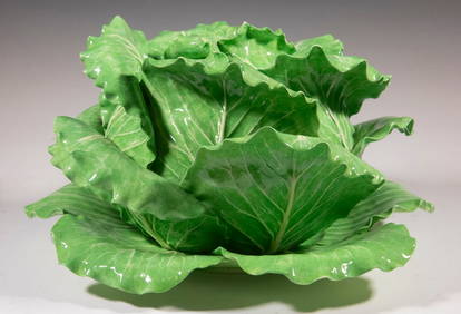
DODIE THAYER (US, 20TH C.) MAJOLICA TUREENThomaston Place Auction Galleries4.4(386)See Sold PriceFeb 25, 2024
CARROLL THAYER BERRY (ME, 1886-1978)Thomaston Place Auction Galleries4.4(386)See Sold PriceFeb 25, 2024
CARROLL THAYER BERRY (ME, 1886-1978)Thomaston Place Auction Galleries4.4(386)See Sold PriceFeb 25, 2024
Nova Totius Full Color Geographical World MapThe Benefit Shop Foundation Inc.4.3(2.9k)See Sold PriceFeb 28, 2024
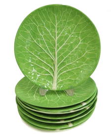
8 Dodie Thayer Jupiter Earthenware Lettuce Dinner PlatesTaylor & Harris4.7(158)See Sold PriceMar 10, 2024
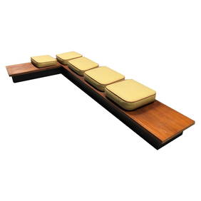
Milo Baughman for Thayer Coggin Mid Century Platform Sofa Walnut BenchBidhaus4.3(747)See Sold PriceFeb 24, 2024
Keith Haring - Ink on New York Map, Best Buddies, Inscribed, Signed, and DatedSapphire Auction Gallery4(67)See Sold PriceMar 02, 2024
Rand McNally Railroad Map Cabinet w/ 21 Railroad MapsRail & Road Auctions4.6(165)See Sold PriceMar 08, 2024
Willem Blaeu, Etc. 17th C. Antiquarian Maps, 2Auctions at Showplace4.5(726)See Sold PriceMar 17, 2024
Putnam - First Map of the State of Ohio by Rufus PutnamTrillium Antique Prints & Rare Books4.5(30)See Sold PriceFeb 24, 2024
Pair of Mid-Century Modern Milo Baughman Lounge Chairs, Thayer CogginPUBLIC SALE4.7(217)See Sold PriceMar 02, 2024


![[MAP]. ENSIGN & THAYER. Ornamental Map of the US.. 1848 (1 of 4)](https://p1.liveauctioneers.com/514/38480/16487178_1_x.jpg?height=282&quality=70&version=1363614971)