ATLAS of ANTIENT GEOGRAPHY by SAMUEL BUTLER 1843John McInnis Auctioneers,LLC4.6(502)See Sold PriceFeb 24, 2024
18TH C. ANTIQUE MAP: FRENCH & INDIAN WAR, FRAMEDThomaston Place Auction Galleries4.4(386)See Sold PriceFeb 24, 2024
Rand McNally Railroad Map Cabinet w/ 21 Railroad MapsRail & Road Auctions4.6(165)See Sold PriceMar 08, 2024
Keith Haring - Ink on New York Map, Best Buddies, Inscribed, Signed, and DatedSapphire Auction Gallery4(67)See Sold PriceMar 02, 2024
LATE 17TH C. FRENCH MAP OF THE NEW WORLD BY ALEXIS-HUBERT JAILLOT (1632-1712)Thomaston Place Auction Galleries4.4(386)See Sold PriceFeb 24, 2024
Central Railroad of New Jersey Map of Sandy Hook Route-ca. 1903JM Hobby Supply and Railroad Artifact Auctions4.4(126)See Sold PriceFeb 24, 2024
Lot of Six Mixed Atlas Box Cars-HO Scale-New in BoxJM Hobby Supply and Railroad Artifact Auctions4.4(126)See Sold PriceFeb 25, 2024
Rand McNally/Santa Fe Railroad Map of Iowa-1912JM Hobby Supply and Railroad Artifact Auctions4.4(126)See Sold PriceFeb 24, 2024
NICOLAES VISSCHER (NETHERLANDS, 1618-1709) MAP OF THE NEW WORLDThomaston Place Auction Galleries4.4(386)See Sold PriceFeb 24, 2024
17TH C. WORLD MAP BY NICOLAES VISSCHER (NETHERLANDS, 1618-1709)Thomaston Place Auction Galleries4.4(386)See Sold PriceFeb 24, 2024
Lot of Six Mixed Atlas Cabooses-HO Scale-New in BoxJM Hobby Supply and Railroad Artifact Auctions4.4(126)See Sold PriceFeb 25, 2024
Tallis/Rapkin: Antique Map of Captain Cook's VoyageTitle/Content of Map: 'The World on Mercator's Projection shewing the voyages of Captain Cook around the World' The track's of Cook's first, second and third voyages are shown, along with dates. DateSee Sold Price
de l'Isle/Dezauche: Antique Map Western Hemisphere 1782Hemisphere Occidental Dresse pour l'usage particulier du Roi. De l'Isle's important Americas map updated by Dezauche to take into account the discoveries and voyages of Captain Cook. The map shows CooSee Sold Price
THE WORLD. 'Shewing the voyages of Captain Cook'. TALLIS/RAPKIN 1851 old mapCAPTION PRINTED BELOW PICTURE: 'The World on Mercator's Projection shewing the voyages of Captain Cook around the World' The track's of Cook's first, second and third voyages are shown, along with datSee Sold Price
THE WORLD. 'Shewing the voyages of Captain Cook'. TALLIS/RAPKIN 1851 old mapCAPTION PRINTED BELOW PICTURE: 'The World on Mercator's Projection shewing the voyages of Captain Cook around the World' The track's of Cook's first, second and third voyages are shown, along with datSee Sold Price
THE WORLD. 'Shewing the voyages of Captain Cook'. TALLIS/RAPKIN 1849 old mapTITLE/CONTENT OF MAP: 'The World on Mercator's Projection shewing the voyages of Captain Cook around the World' The track's of Cook's first, second and third voyages are shown, along with dates. DATESee Sold Price
The World: Shewing the Voyages of Captain Cook 1849 MapThe World. 'Shewing the Voyages of Captain Cook'. Tallis/rapkin 1849 Old Map. Title/content of Map: 'the World on Mercator's Projection Shewing the Voyages of Captain Cook Around the World' the Track'See Sold Price
Antique Map - Bonthain Bay - Sulawesi Island - Makassar - Indonesia - James CookThis captivating engraving map by Captain James Cook originates from "An Account of the Voyages Undertaken by the Order of His Present Majesty for Making Discoveries in the Southern Hemisphere" by JohSee Sold Price
Antique Map - Tierra del Fuego - Le Maire Strait - Bay of Good Success - J. CookThis captivating engraving map by Captain James Cook originates from "An Account of the Voyages Undertaken by the Order of His Present Majesty for Making Discoveries in the Southern Hemisphere" by JohSee Sold Price
Antique Chart 1774 - Cape Providence - Island Bay - Oceania - James Cook VoyageTitle: Antique Chart 1774 - Cape Providence - Island Bay - Oceania - James Cook Voyage Description: This captivating engraving map by Captain James Cook originates from "An Account of the Voyages UndeSee Sold Price
Antique Chart - Elizabeth Bay - Island Bay - America - St. Davids Bay - ChileTitle: Antique Chart - Elizabeth Bay - Island Bay - America - St. Davids Bay - Chile Description: This captivating engraving map by Captain James Cook originates from "An Account of the Voyages UndertSee Sold Price
Antique Map - Society Islands - Maupiti - Tubai - Bora Bora - Polynesia - CookThis captivating map is from Captain James Cook and John Hawkesworth "An Account of the Voyages Undertaken by the Order of His Present Majesty for Making Discoveries in the Southern Hemisphere." ThisSee Sold Price
Sold1785 Engraving from "Third Voyage of Captain Cook"1785 Antique Engraving from "Third Voyage of Cook" by Benard Drexit, 28 x 43 cm."VUES DE LA COTE OCCIDENTALE D'AMERİQUE.A map of American costal.See Sold Price
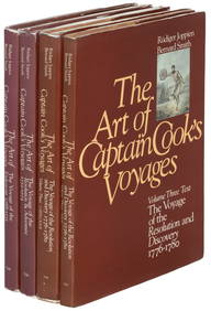
SoldAntique Captain Cook Voyages Books. An Account ofAntique Captain Cook Voyages Books. An Account of the Voyages Undertaken by The Order of His Present Majesty... By John Hawkesworth. London. Printed for W. Strahan and T. Caldwell. 1773. Includes FirsSee Sold Price
Soldc. 1781, Map: Captain Cook VoyagesMapsc. 1781, Map “A Chart and Views of Pitcairns Island", Extremely Fine. Overall size 9" x 15.25" (the actual printed area is smaller). Published in London by Alexander Hogg for use as an illusSee Sold Price
Soldc.1781 Two Maps: Captain Cook VoyagesMapsc. 1781, Dual Map “A Plan of Success Bay in Strait Le Maire / A Chart of the S.E. part of Terra del Fuego, including Strait le Maire and part of Staten Land by Captn. Cook 1769", Extremely FSee Sold Price
Soldc.1781 Two Maps: Captain Cook VoyagesMapsc. 1781, Dual Map “A Plan of Success Bay in Strait Le Maire / A Chart of the S.E. part of Terra del Fuego, including Strait le Maire and part of Staten Land by Captn. Cook 1769", Extremely FSee Sold Price
Soldc. 1781, Map: Captain Cook VoyagesMapsc. 1781, Map “A Chart and Views of Pitcairns Island", Extremely Fine. Overall size 9" x 15.25" (the actual printed area is smaller). Published in London by Alexander Hogg for use as an illusSee Sold Price
Soldc.1781 Two Maps: Captain Cook VoyagesHistoric Maps c. 1781, Dual Map “A Plan of Success Bay in Strait Le Maire / A Chart of the S.E. part of Terra del Fuego, including Strait le Maire and part of Staten Land by Captn. Cook 1769", ExtreSee Sold Price
Soldc. 1781, Map: Captain Cook VoyagesMapsc. 1781, Map “A Chart and Views of Pitcairns Island", Extremely Fine. Overall size 9" x 15.25" (the actual printed area is smaller). Published in London by Alexander Hogg for use as an illusSee Sold Price
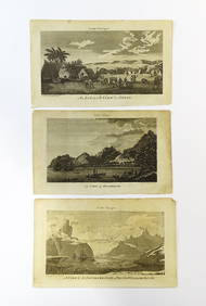
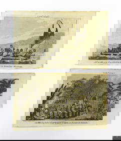
Soldc.1781 Twenty Maps of Captain Cook VoyagesMapsc. 1781, 20 Maps relating to the Voyages of Captain James Cook, Choice Very Fine. Published in London by Alexander Hogg for use as illustrations in books describing Capt. James Cook’s voyageSee Sold Price
Soldc.1781 Twenty Maps of Captain Cook Voyages"MapsTwenty Maps & Views Relating to the Voyages of Captain James Cook c. 1781, 20 Maps relating to the Voyages of Captain James Cook, Choice Very Fine. Published in London by Alexander Hogg for use aSee Sold Price
Soldc.1781 Seven Maps of Captain Cook VoyagesMapsMaps of the Voyages of Captain James Cook c. 1781, Seven Maps relating to the Voyages of Captain James Cook, Choice Very Fine to Extremely Fine. Published in London by Alexander Hogg for use as ilSee Sold Price
Soldc.1781 Twenty Maps of Captain Cook VoyagesMapsc. 1781, 20 Maps relating to the Voyages of Captain James Cook, Choice Very Fine. Published in London by Alexander Hogg for use as illustrations in books describing Capt. James Cook’s voyageSee Sold Price
SoldSeven Maps of Captain Cook Voyages, c. 1781MapsMaps of the Voyages of Captain James Cook c. 1781, Seven Maps relating to the Voyages of Captain James Cook, Choice Very Fine to Extremely Fine. Published in London by Alexander Hogg for use as ilSee Sold Price
1789 Captain James Cook Life & Voyages Australia New Zealand Hawaii KippisSchilb Antiquarian Rare Books4.8(421)See Sold PriceMar 10, 2024
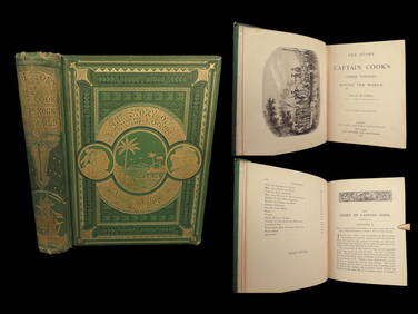
1871 Captain Cook Voyages Around the World Tahiti Hawaii Exploration AntarcticaSchilb Antiquarian Rare Books4.8(421)See Sold PriceMar 10, 2024
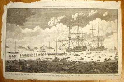
ALEXANDER HOGG ca1790 Engraving Captain Mulgrave Ships Ice Bound Cpt CookLuis Porretta Fine Arts4.3(10)See Sold PriceMar 02, 2024
D'Entrecasteaux - Tasmania, Australia: Map of the Northern Portion of Recherche Bay. 5Trillium Antique Prints & Rare Books4.5(30)See Sold PriceFeb 24, 2024
D'Entrecasteaux - Map of Australia (New Holland), New Zealand, and southern Asia and surroundingTrillium Antique Prints & Rare Books4.5(30)See Sold PriceFeb 24, 2024
After Beilby & Bewick, 18th century, Engravings, Cook's Voyages - A View of Snug Corner Cover inClaydon Auctioneers Ltd4.3(125)See Sold PriceFeb 26, 2024
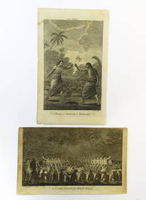
After Beilby & Bewick, 18th century, Engravings, Cook's Voyages - An Offering before Captain Cook inClaydon Auctioneers Ltd4.3(125)See Sold PriceFeb 26, 2024
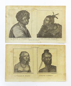
After Beilby & Bewick, 18th century, Engravings, Cook's Voyages - A Woman of Easoo / A Man ofClaydon Auctioneers Ltd4.3(125)See Sold PriceFeb 26, 2024
After Beilby & Bewick, 18th century, Engravings, Cook's Voyages - A Night Dance by Men in Hapae, andClaydon Auctioneers Ltd4.3(125)See Sold PriceFeb 26, 2024
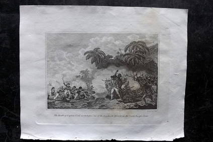
Cooke, George 1801 Print. Death of Captain Cook at Hawaii USAAlbion Auctions4.6(336)See Sold PriceMar 07, 2024
Barthelemy, Jean 1790 Map. Greece - Essa sur la Bataille de PlateeAlbion Auctions4.6(336)See Sold PriceMar 01, 2024
Barthelemy, Jean 1790 Map. Greece - Plan de L'AcademieAlbion Auctions4.6(336)See Sold PriceMar 01, 2024
Barthelemy, Jean 1790 Map. Greece - Essai sur les Environs de DelphesAlbion Auctions4.6(336)See Sold PriceMar 01, 2024
James Cook - Antique map Australia titled 'Gezigt van het Eil. Suffren'. Antique map of SuffrenProverde Auctions4.3(3)See Sold PriceFeb 28, 2024
Antique Map - Views on the coast of Asia. J. Webber del. Engraved after J. Webber and W. Bligh.Proverde Auctions4.3(3)See Sold PriceFeb 28, 2024