SoldTabula Italiae Corsicae...[Europe/Italy]. Tabula Italiae Corsicae Sardiniae et Adjacentium Regnorum. Folding map. Anonymous. Attributed to Gerard Mercator or Philip Cluver. [Ca. 1630’s to 1660’s.] At outer edge of border:See Sold Price
Italy.- Jansson (Jan) Tabulae Italiae, Corsicae,Italy.- Jansson (Jan) Tabulae Italiae, Corsicae, Sardiniae, et Adjacentium Regnorum. Nova et Accurata Delineatio, highly decorative carte-a-figures map of Italy, surrounded on four sides by engravingsSee Sold Price
Sold10 Maps: Italy, Gulf of Venice, Israel.[Italy/Israel] 10 Maps. ++ Tabula Italiae Corsicae, Sardiniae et adjacentium Reigionorum. Shows Italy, Corsica, Sardinia, and northern Sicily. Variously attributed to Mercator, Jansson, and Cluver. [1See Sold Price
Sold1640 TABULA ITALIAE, CORSICAE,SARDINIAE,JanssonMapsGorgeous 1640 Handcolored Engraved Map of Italy by Jansson! 1640, “TABULA ITALIAE, CORSICAE, SARDINIAE...,” by Jan Jansson, Amsterdam, Choice Very Fine. 18” x 21.25”, coppeSee Sold Price
SoldDankero, CornelioDankero, Cornelio Tabula Italiae, Corsicae, Sardiniae et adjacentium regnorum… Première moitié XVIIe, aquarellée. Carte un peu salie, quelques plis sans gravité. 38 x 48 cm.See Sold Price
Sold1764 d'Anville Map of Ancient Italy -- Tabula ItaliaeTitle/Content of Map: 1764 d'Anville Map of Ancient Italy -- Tabula Italiae Antiquae Geographica . . . MDCCLXIV Date: 1764, London Cartographer: J d'AnvilleSize: 24.2 x 19.2 in. An excellent large forSee Sold Price
1764 d'Anville Map of Ancient Italy -- Tabula ItaliaeTitle/Content of Map: 1764 d'Anville Map of Ancient Italy -- Tabula Italiae Antiquae Geographica . . . MDCCLXIV Date: 1764, London Cartographer: J d'Anville Size: 24.2 x 19.2 in. An excellent large foSee Sold Price
Sold[ITALY]. D'Anville. Tabula Italiae Antiquae G[ITALY]. D'Anville. Tabula Italiae Antiquae Geographica...1764. Double-page engraved map, outline color. 25 x 18 1/2. Fine condition, verso blank. This is a live auction at our physical auction gallerSee Sold Price
1764 d'Anville Map of Ancient Italy -- Tabula ItaliaeTitle/Content of Map: 1764 d'Anville Map of Ancient Italy -- Tabula Italiae Antiquae Geographica . . . MDCCLXIV Date: 1764, London Cartographer: J d'Anville Size: 24.2 x 19.2 in. An excellent large foSee Sold Price
Tabula Italiae Antiqua Geographica...Title/Content of Map: Tabula Italiae Antiqua Geographica... Date: 1764 Cartographer: ANVILLE, J.B.B. D' Publisher: D'ANVILLE Size: 24.75Height - 19.6Width Map detailing provinces, towns, topography, pSee Sold Price
Tabula Italiae Antiqua Geographica...Title/Content of Map: Tabula Italiae Antiqua Geographica... Date: 1764 Cartographer: ANVILLE, J.B.B. D' Publisher: D'ANVILLE Size: 24.75Height - 19.6Width Map detailing provinces, towns, topography, pSee Sold Price
1764 d'Anville Map of Ancient Italy -- Tabula ItaliaeReserve Reduced! Title/Content of Map: 1764 d'Anville Map of Ancient Italy -- Tabula Italiae Antiquae Geographica . . . MDCCLXIV Date: 1764, London Cartographer: J d'Anville Size: 24.2 x 19.2 in. An eSee Sold Price
1764 d'Anville Map of Ancient Italy -- Tabula ItaliaeTitle/Content of Map: 1764 d'Anville Map of Ancient Italy -- Tabula Italiae Antiquae Geographica . . . MDCCLXIV Date: 1764, London Cartographer: J d'Anville Size: 24.2 x 19.2 in. An excellent large foSee Sold Price
SoldMap of 18th Century Tabula Italiae Antique,handcoloured etching, framed, 51cm x64cmSee Sold Price
Tabula Italiae Antiqua Geographica...Title/Content of Map: Tabula Italiae Antiqua Geographica... Cartographer: ANVILLE, J.B.B. D' Height (inches): 24.75 Width (inches): 19.6Year: 1764 Map detailing provinces, towns, topography, ports, etSee Sold Price
Tabula Italiae Antiqua Geographica...Publication Date: 1764 Title: Tabula Italiae Antiqua Geographica... Cartographer: D'ANVILLE, J. B. B. Publisher: D'ANVILLE Height: 24.75 Width: 19.6 Map detailing provinces, towns, topography, ports,See Sold Price
Tabula Italiae Antiqua Geographica...Publication Date: 1764 Title: Tabula Italiae Antiqua Geographica... Cartographer: ANVILLE, J.B.B. D' Publisher: D'ANVILLE Height: 24.75 Width: 19.6 Map detailing provinces, towns, topography, ports, eSee Sold Price
Tabula Italiae Antique...Title/Content of Map: Tabula Italiae Antique... Cartographer: ANVILLE, JEAN BAPTISTE BOURGUIGNON D. Height (inches): 24.8 Width (inches): 19.6Year: 1764 Very detailed classical map. Small inset of ancSee Sold Price
SoldMap of 18th Century Tabula Italiae Antique,handcoloured etching, framed, 51cm x 64cmSee Sold Price
de Wit: Antique Dutch Map of Italy, 1680Title: Novissima et Accuratissima totius Italiae Corsicae et Sardiniae Descriptio. Lovely 17th century Dutch map of Italy Map maker: Frederick de Wit Place and Year: Amsterdam, c. 1680 Dimensions: 56.See Sold Price
SoldMap, Frederick de Wit, Novissima et AccuratissimaFrederick de Wit (Dutch, 1616-1689), Novissima et Accuratissima Totius Italiae Corsicae et Sardiniae, Descriptio Correcta Mutis Aucta et in Lucem, circa 1680, hand-colored copper engraved map, sheet (See Sold Price
SoldD'anville Map of Ancient ItalyD'Anville, Jean Baptiste Bourguignon (1697-1782). Tabula Italiae Antique... Engraved map. D'Anville, 1764. 24 ¾" x 19 ½" sheet. Very detailed classical map. Small inset of ancient Rome. Round inSee Sold Price
SoldTwo D'Anville Maps of Classical LandsTwo D'Anville Maps of Classical Landsas follows: Graeciae Antiquae Specimen Geographicum and Tabula Italiae Antiqua, Geographica (London: Laurie & Whittle, 1794), copperplate engravings with outline cSee Sold Price
D'anville Map of Ancient ItalyD'Anville, Jean Baptiste Bourguignon (1697-1782). Tabula Italiae Antique Geographica... Engraved map. D'Anville, 1764. 24 ¾" x 19 ½" sheet. Map detailing provinces, towns, topography, ports, etcSee Sold Price
17TH C. WORLD MAP BY NICOLAES VISSCHER (NETHERLANDS, 1618-1709)Thomaston Place Auction Galleries4.4(389)See Sold PriceFeb 24, 2024
NICOLAES VISSCHER (NETHERLANDS, 1618-1709) MAP OF THE NEW WORLDThomaston Place Auction Galleries4.4(389)See Sold PriceFeb 24, 2024
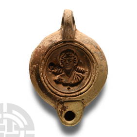
Roman Terracotta Lamp with Fighting GladiatorsTimeLine Auctions Ltd.4.6(182)See Sold PriceMar 05, 2024
Nova Totius Full Color Geographical World MapThe Benefit Shop Foundation Inc.4.3(2.9k)See Sold PriceFeb 28, 2024
De Jode, Rare, pub. 1593 - Map of Italy (Italiae Totius Orbis olim Domatricis Nova ExactissTrillium Antique Prints & Rare Books4.5(30)See Sold PriceFeb 24, 2024
1736 LARGE MAP OF SILESIA POLAND OPPAVIENSIS antique 25 by 34 3/4"Jasper524.5(9.8k)See Sold PriceFeb 28, 2024
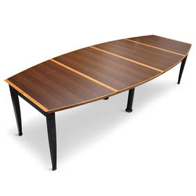
Tabula Magna Dining Table by Oscar Tosquets Blanca for Driade Aleph (1991)Jasper524.5(9.8k)See Sold PriceFeb 28, 2024
EPICTETUS ENCHIRIDIUS'S ANCIENT VELLUM TREATISE ON VEGETARIANISM, PUBLISHED IN 1655NY Elizabeth 4.3(85)See Sold PriceMar 03, 2024
SOEMMERING, SAMUEL THOMAS.1755-1830. Tabula baseos encephali. Frankfurt: by the author, 1799.Bonhams4.1(315)See Sold PriceJun 18, 2024


![[ITALY]. D'Anville. Tabula Italiae Antiquae G (1 of 1)](https://p1.liveauctioneers.com/179/10971/2682741_1_x.jpg?height=282&quality=70&version=1162265652)