ATLAS of ANTIENT GEOGRAPHY by SAMUEL BUTLER 1843John McInnis Auctioneers,LLC4.6(504)See Sold PriceFeb 24, 2024
18TH C. ANTIQUE MAP: FRENCH & INDIAN WAR, FRAMEDThomaston Place Auction Galleries4.4(389)See Sold PriceFeb 24, 2024
Rand McNally Railroad Map Cabinet w/ 21 Railroad MapsRail & Road Auctions4.6(165)See Sold PriceMar 08, 2024
Keith Haring - Ink on New York Map, Best Buddies, Inscribed, Signed, and DatedSapphire Auction Gallery4.1(67)See Sold PriceMar 02, 2024
LATE 17TH C. FRENCH MAP OF THE NEW WORLD BY ALEXIS-HUBERT JAILLOT (1632-1712)Thomaston Place Auction Galleries4.4(389)See Sold PriceFeb 24, 2024
Central Railroad of New Jersey Map of Sandy Hook Route-ca. 1903JM Hobby Supply and Railroad Artifact Auctions4.4(126)See Sold PriceFeb 24, 2024
Lot of Six Mixed Atlas Box Cars-HO Scale-New in BoxJM Hobby Supply and Railroad Artifact Auctions4.4(126)See Sold PriceFeb 25, 2024
Rand McNally/Santa Fe Railroad Map of Iowa-1912JM Hobby Supply and Railroad Artifact Auctions4.4(126)See Sold PriceFeb 24, 2024
NICOLAES VISSCHER (NETHERLANDS, 1618-1709) MAP OF THE NEW WORLDThomaston Place Auction Galleries4.4(389)See Sold PriceFeb 24, 2024
17TH C. WORLD MAP BY NICOLAES VISSCHER (NETHERLANDS, 1618-1709)Thomaston Place Auction Galleries4.4(389)See Sold PriceFeb 24, 2024
Lot of Six Mixed Atlas Cabooses-HO Scale-New in BoxJM Hobby Supply and Railroad Artifact Auctions4.4(126)See Sold PriceFeb 25, 2024
SoldAtlas of 17th Century Antique Maps - 45Hand made atlas consisting of 45 17th Century European maps. All hand drawn and hand colored. Maps by Blaeuw, Hondius, Homann et al. One map carries a date of 1610. All maps laid on paper. Book 16.5"See Sold Price
SoldMap of the Americas 1614 Copper Plate Engraving 17C MapCopper Plate Engraved 17C Map of The Americas. The 17th century antique map title is "Americae Nova Descriptio" and dated 1614. A copperplate engraving by Abraham Goos with hand coloring. The 17th cenSee Sold Price
Tassin: Antique Map of Calais, France, 1636Title/Content of Map: Fine 17th century antique map of Calais, France Date Printed: 1636 Cartographer: Tassin, Christophe Nicholas Size (inches): 6 x 4 Full contemporary hand color Antique engraved viSee Sold Price
SoldJOHN SPEED 1676 New Description of Carolina Old 17C MapJohn Speed 17C New Description of Carolina Map. The early antique 17th century map is titled John Speed New Description of Carolina, London 1676. A copper plated engraving by Francis Lamb with hand coSee Sold Price
Antique map Scotia Regnum. 17th century. Hand colored.Antique map Scotia Regnum. 17th century. Hand colored. A few minor damage at the rim. Size: 53 x 51 cm. In reasonable / good condition.See Sold Price
SoldMap, Ducatus Silesiae Wolanus, Iona ScultetoAn antique map of Poland. 17th century. c.1660. Titled Ducatus Silesiae Wolanus, Author, Jona Sculteto, Sprotta Silesio. A copperplate engraving in full color. The sheet measures 20.5" x 24". AppearsSee Sold Price
Sold18th CENTURY ANTIQUE small MAP OF SWEDEN & NORWAYSize 8.5 by 11.5" Very good condition Reserve: $39.99 Shipping: Domestic: Flat-rate of $10.00 to anywhere within the contiguous U.S. International: Foreign shipping rates are determined by destinationSee Sold Price
SoldVisscher: Antique Map of Africa, 1670Title: Africæ Accurata Tabula. 17th century Visscher map of Africa Map maker: Nicolas Visscher Place and Year: Amsterdam, c. 1670 Dimensions: 43.5 x 54 cm (17¼ x 21¼ in) Technique: Copperplate engrSee Sold Price
Blaeu: Antique Map of Italy & Islands, 1635Title: "Nova Italiae Delineatio", Beautiful mid-17th century hand-colored map of Italy and surrounding islands Map maker: Willem Janszoon Blaeu Place and Year: Amsterdam, c. 1635 Dimensions: 51.0 x 59See Sold Price
SoldMorisot: Antique Map of North America, 1643Title: Americae Septentrionalis Circuitus. Mid-17th century French copperplate map with cartographic myths Map maker: Claude Bartholomy Morisot Place and Year: Dijon, 1643 Dimensions: 16.6 x 13.5 cm (See Sold Price
SoldAntique Map Of Italian Papal States Near RomeProbably 17th Century, Hand Colored Engraving With Patrimonio Di S. Pietro Sabina Et Ducato Di Castro, Sight 14 X 18 Inches, Later Frame 19 X 23 X 1 Inches. See Photos For Condition.See Sold Price
SoldJanssonius: Antique Map of Portugal, 1645Title: Portugallia et Algarbia quae olim Lusitania. Attractive mid-17th century map of Portugal Map maker: Jan Janssonius Place and Year: Amsterdam, [c.1645] Dimensions: 38.5 x 49.5 cm (15¼ x 19½ inSee Sold Price
Janssonius: Antique Map of Portugal, 1645Title: "Portugallia et Algarbia quae olim Lusitania". Attractive mid-17th century map of Portugal Map maker: Jan Janssonius Place and Year: Amsterdam, [c.1645] Dimensions: 38.5 x 49.5 cm (15¼ x 19½See Sold Price
SoldAntique Map of Roman Army, Forche Caudine, 16th-17th CTitle/Content of Map: Forche Caudine Not signed Map of the passage Roman Army trought the " Forche Caudine". Roma's Year 432. Date: Not dated, 16th/17th century circa. Size Sheet: 36,5 x 27 cm. <See Sold Price
Jalliot/Mortier: Antique Map of Africa, 1695Title: L'Afrique Divisee Suivant l'Estendue de Ses Principales Parties ou sont Distingues les uns des Autres...Late 17th century Jaillot map of Africa Map maker: Alexis-Hubert Jalliot, Pierre MortierSee Sold Price
Coronelli: Antique Map of Island of Corfu Greece, 1686Title/Content of Map: 17th century map of the Island of Corfu, Greece. Isola di Corfu Date Printed: 1686 Cartographer: Coronelli, Vincenzo Size (inches): 7 x 5 Fine antique map of the Greek island ofSee Sold Price
SoldA framed antique map, John Speed17th century, London Hand-tinted copper-engraved map on paper under glass, The Kingdome of Ireland, with 6 vignettes of peoples of Ireland, by John Speed Image: 15" H x 20" W Provenance: Private ColleSee Sold Price
Antique Map of the Fortress of Dantziger Hoeft, 17th CAntique map, Geometrica delineatio minitionis Dantziger Hoeft 17th century. Image size: 9.5" x 12" overall size 13" x 16". "A provisional camp was set up on the 4th April whilst permanent defences werSee Sold Price
SoldAntique Map of Volga RiverCartographer, Adam Olearius. Hand colored engraving, 16th/17th century. In two parts. Sight size 19 3/4 x 23 inches. Framed. Notice to bidders: Condition reports and additional photographs are provideSee Sold Price
Antique Map of Battle of Eraclea, 16th-17th Cent.Battle of Eraclea Not signed Map of the battle of Eraclea Not dated, 16th/17th century circa. Paper Size Sheet: 36,5 x 27 cm. Please note that this lot has a confidential reserve. When you leave a bidSee Sold Price
SoldAntique map of AustriaAntique map of Austria by George M. Vischer and Baptista Homanno circa 17th century est. value $1500.00-$2000.00See Sold Price
Antique map of AustriaAntique map of Austria by George M. Vischer and Baptista Homanno circa 17th century est. value $1500.00-$2000.00See Sold Price
SoldSMALL GROUP OF ANTIQUE MAPS17th and 18th Century undated maps include four small 17th Century maps of England and a 17th or 18th Century map of North Africa. Interesting grouping. Largest is 10 1/2" x 11"See Sold Price
SoldAntique maps(lot of 3) Framed 17th century engraved map, "Landau, Ville au Roy et Fortifiee d'une Novelle Maniere...du Coste Occidental", by Nicolas de Fer (French 1646-1720), from "Les Forces de l'Europe", frameSee Sold Price
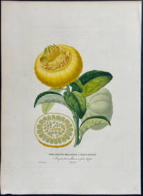
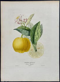
Risso - Lemon or Citrus Fruit. 73Trillium Antique Prints & Rare Books4.5(30)See Sold PriceFeb 24, 2024
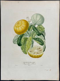
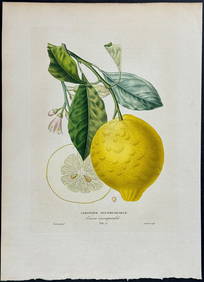
Risso - Lemon or Citrus Fruit. 71Trillium Antique Prints & Rare Books4.5(30)See Sold PriceFeb 24, 2024
1816 MAP NORTHERN PART OF RUSSIA or MUSCOVY in EUROPE copper engraving ANTIQUEJasper524.5(9.8k)See Sold PriceFeb 27, 2024
WEST AFRICA Niger/Gambia rivers tribes towns. 'Pays des Negres'. MALLET 1683 mapJasper524.5(9.8k)See Sold PriceFeb 28, 2024
WEST AFRICA. People of Guinea. 'Peuples de Guinée'. Costume. MALLET 1683 printJasper524.5(9.8k)See Sold PriceFeb 28, 2024
WEST AFRICA. Guinea. Nigeria Ghana Benin Togo Sierra Leone. MALLET 1683 mapJasper524.5(9.8k)See Sold PriceFeb 28, 2024
WEST CENTRAL AFRICA. Congo Angola Gabon Cameroon Sao Tome. MALLET 1683 old mapJasper524.5(9.8k)See Sold PriceFeb 28, 2024
NORTH AFRICA. 'Biledulgerid', a former North African country. MALLET 1683 mapJasper524.5(9.8k)See Sold PriceFeb 28, 2024
WEST AFRICA/MAGHREB Tribes Garamantes Getgulie 'Ancienne Libye'. MALLET 1683 mapJasper524.5(9.8k)See Sold PriceFeb 28, 2024
MALLET. Description de l'Univers. Africa. Volume 3 title page. MALLET 1683Jasper524.5(9.8k)See Sold PriceFeb 28, 2024
NORTH AFRICA. Barbary. Morocco Tunisia Libya Egypt. 'Barbarie'. MALLET 1683 mapJasper524.5(9.8k)See Sold PriceFeb 28, 2024
NORTH AFRICA. Morocco Tunisia Libya. 'Mauritanie'. Malta Melita. MALLET 1683 mapJasper524.5(9.8k)See Sold PriceFeb 28, 2024
NUBIA. 'Nubie'. Nile Valley. Sudan Ethiopia Egypt. MALLET 1683 old antique mapJasper524.5(9.8k)See Sold PriceFeb 28, 2024
SUB-SAHARAN AFRICA. 'Ancienne Ethiopie'. Ancient Ethiopia. MALLET 1683 old mapJasper524.5(9.8k)See Sold PriceFeb 28, 2024
1675: ANTIQUE ILLUSTRATED JULIUS CAESAR MAPS OF ROMAN HISTORYNY Elizabeth 4.3(85)See Sold PriceMar 03, 2024
Lot of 12 Portraits - Emmanuel Pérès de Lagesse - Anton Van Dyck - George Howland BeaumontProverde Auctions4.3(3)See Sold PriceFeb 28, 2024
Lot of 16 Portraits - Raphael - Michael Stecher Walther - Peder Oxe - Albrecht, archduke of AustriaProverde Auctions4.3(3)See Sold PriceFeb 28, 2024
Lot of 30 Portraits - Johannes Nikolaus Tetens - Jacob de Witt - Georg Christoph Lichtenberg -Proverde Auctions4.3(3)See Sold PriceFeb 28, 2024
Lot of 30 Portraits - Adolph Hendrik - Cornelis van Aerssen - Peder Hanson Resen - Jacob van derProverde Auctions4.3(3)See Sold PriceFeb 28, 2024
Set of 6 Lithograph Prints of Dalarna Cabinets, Nordic Textiles, and Baroque Elegance - 1800sProverde Auctions4.3(3)See Sold PriceFeb 28, 2024