SoldStoopendaal 1729 Map of Near & Middle EastDESCRIPTION: "De Gelegentheyt Paradys en't Landt Canaan, Mitsgaders d' Eerst Bewoonde Landen der Patriarchen." This Dutch Bible map features region between the Mediterranean and the Persian Gulf. InclSee Sold Price
Sold3 Middle & Near East Maps, plus Text Sheet & Carved Heraldic Wall Plaque, 5 items1st item: DE BESCHRYVING VAN DE REYSEN PAULI, EN VAN DE ANDERE APOSTELEN map, engraved by Daniel Stoopendaal after Bastian Stoopendaal, published by Pieter and Jacob Keur, Amsterdam, ca. 1730. CopperpSee Sold Price
SoldMAP - Mediterranean & Middle East. StoopendaalEastern Mediterranean & Middle East. Daniel Stoopendaal, De Beschryvingh van de Reysen Pauli, en van de Andere Apostelen..., 1729 (published). Hand Color. This beautiful map of the eastern MediterraneSee Sold Price
Blaeu 1647 Map of Near & Middle EastDESCRIPTION: This map, created by Willem Blaeu and Joan Blaeu, features a title cartouche "Turcicum Imperium" showing a Turkish Sultan on his throne, flanked by armed allegorical figures. Also includeSee Sold Price
SoldVarious. 16 maps of the Middle East. 17-19th cent.[Near/ Middle East] 16 maps. Various maps of the Near and Middle East, mostly 19th century. (1) [After Ptolemy] “Tabula Asiae V.” c. 17th century. Weller, Edward. (2) “The Isthmus ofSee Sold Price
PhilipsTitle/Content of Map: Philips' Regional Wall Map of the Near East and Middle East (Land of the Five Seas) Cartographer: FULLARD, HAROLD Date: c1956 Publisher: GEORGE PHILIP & SON, LTD. Size: 45HeightSee Sold Price
MAP, Mediterranean & Middle East, StoopendaalEastern Mediterranean & Middle East. Daniel Stoopendaal, De Beschryvingh van de Reysen Pauli, en van de Andere Apostelen..., 1736 (circa). Black & White. This beautiful map of the eastern MediterraneaSee Sold Price
MAP, Mediterranean & Middle East, StoopendaalEastern Mediterranean & Middle East. Daniel Stoopendaal, De Beschryvingh van de Reysen Pauli, en van de Andere Apostelen..., 1710 (published). Black & White. This beautiful map of the eastern MediterrSee Sold Price
Sold[Middle, Near & Far East]. 3 Maps.[Middle, Near & Far East]. 3 Maps. ++ Partie Orientale De La Carte Des Ancienes Monarchies. [c1750]. Double-page engraving, 20 x 25. Fine. Political boundaries in the ancient world with perimeter of eSee Sold Price
SoldEurope.- Roman Empire.- Ortelius (Abraham) RomaniEurope.- Roman Empire.- Ortelius (Abraham) Romani Imperii Imago, map of the Roman Empire centered on the Mediterranean and covering most of Europe, Northern Africa, and the Near and Middle East, withSee Sold Price
SoldEurope.- Roman Empire.- Ortelius (Abraham) RomaniEurope.- Roman Empire.- Ortelius (Abraham) Romani Imperii Imago, map of the Roman Empire centered on the Mediterranean and covering most of Europe, Northern Africa, and the Near and Middle East, withSee Sold Price
Soldde Vaugondy. Etats du Grand-Seigneur. 1753.[Near and Middle East] de Vaugondy, Robert (French, 1688-1766). "Etats du Grand-Seigneur en Asie, Empire de Perse, Pays des Usbecs, Arabie et Egypte." 1753. Copper-engraved map centered on the ArabianSee Sold Price
The Middle East. Cornelius Dankerts. Holland, 1646Armeniae Maioris Nova Discriptio. Map of the Near East. The Israelites' journey in the desert. Abraham's journey from Ur to Nablus. By Cornelius Dankerts. Holland, 1646. Dutch. 47.5x33.6 cm. (54.5x41See Sold Price
SoldMap of Judea, Samaria and the Jordan Valley; map ofMap of Judea, Samaria and the Jordan Valley; map of Tel Aviv, map of Jerusalem; map of the Near East and Asia; map of Egypt; map of Iraq; map of the oil route in the Middle East; map of the Land of IsSee Sold Price
Map of Caucasia and the Near East. Sebastian Munster.Tabula Asiae Ii. Map of Caucasia and the Middle East. Armenia - southwest Russia. Between the Black and Caspian Seas. Noah's ark demarcated on the mountains of Armenia. Black and white, woodcut. By SeSee Sold Price
SoldMap of Caucasia and the Near East. Sebastian Munster.Tabula Asiae Ii. Map of Caucasia and the Middle East. Armenia – southwest Russia. Between the Black and Caspian Seas. Noah’s ark demarcated on the mountains of Armenia. Black and white,See Sold Price
Map. The Holy Land and the Near East. NocolasParadaise or the Garden of Eden. A map of the Holy Land and the Middle East. Attractive copper engraving. Black and white. By Nicolas Visscher. Translated by Joseph Moxon. Amsterdam 1671. The map indiSee Sold Price
SoldMid to Near East: 18 Hand colored Maps[Mid & Near East]. 18 hand-colored maps featuring Greece, Turkey, and countries in the Middle East, mostly from various editions of the Johnson Family Atlas, 1850s - 1860s. Some duplicates, each approSee Sold Price
Sold6 Maps: 4 Mideast, 2 Civil War.[Middle East] 6 Maps. Sight condition very good to near fine where not otherwise noted. Matted and under glass. ++ IRAN AND TURAN, (PERSIEN, AFGHANISTAN, BILUDSCHISTAN, TURKESTAN.) Gotha: Justus PerthSee Sold Price
Aaronsohn's Maps, 1st EdTitle: Aaronsohn's Maps. The Untold Story of the Man Who Might Have Created Peace in the Middle East. Orlando. Harcourt. 2007 Author(s): Goldstone, Patricia. First edition. Condition: Fine copy in neaSee Sold Price
SoldMAP, Middle East & Cyprus, SansonMiddle East & Cyprus. Nicolas Sanson, Sorie, et Diarbeck Divises en Leurs Parties, from Geographise en Historise Werelt Beschryving, 1699 (published). Hand Color. Lovely map of Iraq, Syria, the Holy LSee Sold Price
SoldMap - Middle East with watermark on thick rolledMap - Middle East with watermark on thick rolled paper. Along with canister. 30"hSee Sold Price
SoldMAP, Middle East, HondiusEastern Mediterranean & Middle East. Hondius/Purchas, Turcicum Imperium, 1625 (published). Hand Color. This interesting small map extends west to Italy and includes part of northern Africa, but focuseSee Sold Price
MAP - Middle East. Munster/PetriMiddle East. Munster/Petri, Syria / Cypern / Palestina / Mesopotamia / Babylonia / zwey Arabia / mit Bergen / Waesseren und Stetten, 1592 (circa). Hand Color. This woodblock map covers the region fromSee Sold Price
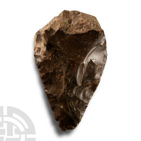
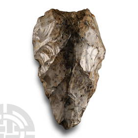
Superb Stone Age 'Dordogne' Toffee-Brown Knapped Flint Ficron Bifacial HandaxeTimeLine Auctions Ltd.4.6(182)See Sold PriceMar 05, 2024
Large Stone Age 'Somme' White Knapped Flint HandaxeTimeLine Auctions Ltd.4.6(182)See Sold PriceMar 05, 2024
Stone Age 'Somme' Grey Speckled White Knapped Flint HandaxeTimeLine Auctions Ltd.4.6(182)See Sold PriceMar 05, 2024
Attractive Stone Age 'Dordogne' Orange-Brown Chalcedony Bifacially Worked HandaxeTimeLine Auctions Ltd.4.6(182)See Sold PriceMar 05, 2024
[MAPS]. DUFOUR, Auguste-Henri (1795-1865). Bound Volume of ...Potter & Potter Auctions4.6(544)See Sold PriceMar 07, 2024
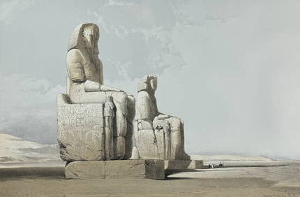
David Roberts - Obelisk of LuxorTrillium Antique Prints & Rare Books4.5(30)See Sold PriceFeb 24, 2024
David Roberts - Approach of the Simoom, Desert of GizehTrillium Antique Prints & Rare Books4.5(30)See Sold PriceFeb 24, 2024
De Jode, Rare, pub. 1593 - Map of the Middle East, Eastern Asia (Primae Partis Asiae accurataTrillium Antique Prints & Rare Books4.5(30)See Sold PriceFeb 24, 2024
WEST AFRICA Explorers' routes Senegal Ashanti. Mountains of Kong. SDUK 1857 mapJasper524.5(9.8k)See Sold PriceFeb 28, 2024
WEST AFRICA explorers' routes. Beaufort Gray Park Dochard Caillie. SDUK 1874 mapJasper524.5(9.8k)See Sold PriceFeb 28, 2024
WEST AFRICA I Explorers' routes Senegal Ashanti Ivory Gold Coast. SDUK 1851 mapJasper524.5(9.8k)See Sold PriceFeb 28, 2024
WEST AFRICA showing early explorers' routes & Mountains of Kong. SDUK 1844 mapJasper524.5(9.8k)See Sold PriceFeb 28, 2024
PRE COLONIAL WESTERN AFRICA. Shows Mountains of Kong. Tribes. WELLER 1863 mapJasper524.5(9.8k)See Sold PriceFeb 28, 2024
Vintage Framed Cat Island Nautical Map PrintRapid Estate Liquidators and Auction Gallery4.5(1.1k)See Sold PriceFeb 25, 2024


![[Middle, Near & Far East]. 3 Maps. (1 of 2)](https://p1.liveauctioneers.com/179/1435/617510_1_x.jpg?height=282&quality=70)


![[MAPS]. DUFOUR, Auguste-Henri (1795-1865). Bound Volume of ... (1 of 2)](https://p1.liveauctioneers.com/928/318880/171361279_1_x.jpg?height=282&quality=70&version=1707501302)