KONVOLUT AUS VIER LANDKARTEN RUSSLAND UND CHINA Abraham Ortelius, Willem Blaeu, Johannes Blaeu,Hargesheimer Kunstauktionen Duesseldorf4.5(136)See Sold PriceMar 09, 2024
SoldEurope.- Roman Empire.- Ortelius (Abraham) RomaniEurope.- Roman Empire.- Ortelius (Abraham) Romani Imperii Imago, map of the Roman Empire centered on the Mediterranean and covering most of Europe, Northern Africa, and the Near and Middle East, withSee Sold Price
SoldEurope.- Roman Empire.- Ortelius (Abraham) RomaniEurope.- Roman Empire.- Ortelius (Abraham) Romani Imperii Imago, map of the Roman Empire centered on the Mediterranean and covering most of Europe, Northern Africa, and the Near and Middle East, withSee Sold Price
MAP, Mediterranean, OrteliusMediterranean, Roman Empire. Abraham Ortelius, Romani Imperii Imago, 1581 (published). Hand Color. Dramatic map of the Roman Empire centered on the Mediterranean and covering most of Europe, NorthernSee Sold Price
SoldAntique Map of Asia and Europe Under Roman Empire,Antique Map of Asia and Europe Under Roman Empire, Romani Imperii qua Oriens est Descriptio Geographicahand-colored copperplate engraving, on laid paper, 17th century, hand coloring may be later, withSee Sold Price
SoldMap of the Roman Empire Stretched Canvas PrintMap of the Roman Empire by Abraham Ortelius 43 x 30 inSee Sold Price
SoldEurope.- Roman Empire.- d'Anville (Jean BaptisteEurope.- Roman Empire.- d'Anville (Jean Baptiste Bourguignon) Orbis Romani Pars Occidentalis, engraved map with outline hand-colouring, sheet 705 x 560 mm. (27 3/4 x 22 in), several old folds, thin tiSee Sold Price
Ortelius, Abraham. Germaniae TypusOrtelius, Abraham Germaniae Typus 1603 Copperplate engraving; coloured Printed area: 48.7 x 37.7 cm; 19.2 x 14.8 in This beautiful, coloured map shows the entirety of the Holy Roman Empire from DenmarSee Sold Price
SoldHand-colored 19th century map of Romani Imperii ImagoHand-colored 19th century map of Romani Imperii Imago (the Roman Empire) by Abraham Ortelios, Antwerp/1609, very good, lower left #3751Provenance: Estate of Mark PontonInv.88See Sold Price
SoldOrbis Romani Pars Orientalis Map 1763Orbis Romani Pars Orientalis Map by cartographer Jean Babtiste Bourguignon 'Anville, original copperplate engaving dated 1763. Depicts Mediterranean Europe and Roman Empire. 12 1/2" H x 9 1/2" W. In gSee Sold Price
SoldOrbis Romani Pars OrientalisTitle: Orbis Romani Pars Orientalis Cartographer: D'Anville, J.B.B. Publication Date: 1764 Publisher: D'Anville Size: Height: 27 Width: 21.5 Map showing eastern Europe or Roman Empire. Details topograSee Sold Price
Orbis Romani Pars OrientalisPublication Date: 1764 Title: Orbis Romani Pars Orientalis Cartographer: D'Anville, J.B.B. Publisher: D'Anville Height: 27 Width: 21.5 Map showing eastern Europe or Roman Empire. Details topography, tSee Sold Price
Orbis Romani Pars OrientalisReserve Reduced! Title: Orbis Romani Pars Orientalis Date: 1764 Cartographer: D'Anville, J.B.B.Publisher: D'Anville Size (inches): 27X21.5 Map showing eastern Europe or Roman Empire. Details topographSee Sold Price
Orbis Romani Pars OrientalisTitle/Content of Map: Orbis Romani Pars Orientalis Date Printed: 1764 Cartographer: D’Anville, J.B.B. Size: 27x21.5 Map showing eastern Europe or Roman Empire. Details topography, towns, etc. tSee Sold Price
Orbis Romani Pars OrientalisTitle/Content of Map: Orbis Romani Pars Orientalis Date Printed: 1764 Cartographer: D’Anville, J.B.B. Size: 27x21.5 Map showing eastern Europe or Roman Empire. Details topography, towns, etc. tSee Sold Price
Orbis Romani Pars OrientalisPublication Date: 1764 Title: Orbis Romani Pars Orientalis Cartographer: D'Anville, J.B.B. Publisher: D'Anville Height: 27 Width: 21.5 Map showing eastern Europe or Roman Empire. Details topography, tSee Sold Price
(ROMAN EMPIRE) ORBIS ROMANI PARS OCCIDENTALISEngraved map 'Orbis Romani, pars occidentalis' showing Europe and Africa, published Norimberge (Nuremberg) in Officina Weigelia-Schneideriana, Author Jean Baptiste Bourguignon d'Anville (1697-1782), eSee Sold Price
Map of Roman Empire. Europe 1829.Print of steel engraving titled Imperii Romani“.Author Fellx Delamarche.Engraved by unknown.From Atlas de la Geographie ancienne du moyen age et moderne“ by Fellx Delamarche. Paris. 1829.Flix DelaSee Sold Price
Map of Asia and Europe under the Roman Empire.Romani Imperii qua Oriens est Descriptio Geographica. The east of the Roman Empire. Includes the Holy Land and the Near East through Persia in the east, Egypt in the south and the Agean Sea in the wesSee Sold Price
Sold1579 Ortelius Map of the Roman Empire -- Romani ImperiiReserve Reduced! Title/Content of Map: 1579 Ortelius Map of the Roman Empire -- Romani Imperii Imago Date: 1579, Antwerp Cartographer: A Ortelius Size: 13.8 X 19.6 in. This is an excellent map of theSee Sold Price
1602 Ortelius Map of Russia -- RussiaTitle: 1602 Ortelius Map of Russia -- Russia Cartographer: A Ortelius Year / Place: 1602, Antwerp Map Dimension (in.): 3 X 4.2 Iin. This rather nice smaller map covers the Russian Empire in Europe andSee Sold Price
1602 Ortelius Map of Russia -- RussiaTitle: 1602 Ortelius Map of Russia -- Russia Cartographer: A Ortelius Year / Place: 1602, Antwerp Map Dimension (in.): 3 X 4.2 Iin. This rather nice smaller map covers the Russian Empire in Europe andSee Sold Price
SoldJansson. Tabula Itineraria.... PeutingerorumJansson (Jan) Tabula Itineraria ex illustri Peutingerorum Bibliothecaafter Ortelius's strip map from classical manuscript source, of roads throughout the Roman empire, from Europe and Africa tSee Sold Price
Romani Imperii Qua Occidens est Descriptio. WesternTITLE/CONTENT OF MAP: Romani Imperii Qua Occidens est Descriptio [The western Roman Empire] Ancient western Europe and the western Mediterranean The top image on the right hand side shows the entire mSee Sold Price
SoldMAP, Russia in Europe, Ortelius/CoignetRussia in Europe. Ortelius/Coignet, Russia, from Epitome Theatri Orbis Terrarum, 1609 (circa). Black & White. This miniature map covers the Russian Empire in Eastern Europe and is embellished with a sSee Sold Price
ABRAHAM ORTELIUS (1527-1598) MAP OF ROMAN GAUL (FRANCE)Thomaston Place Auction Galleries4.4(386)See Sold PriceFeb 24, 2024
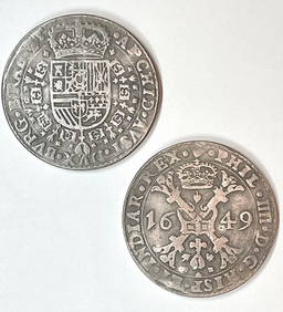
Dated 1649 Holy Roman Empire Large Silver tone CoinSouth Florida Auction & Estate Sale Services Inc4.5(520)See Sold PriceMar 08, 2024
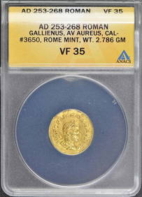
Gallienus AD 253-268 ROMAN EMPIRE AV Aureus ANACS VF35Mynt Auctions4.6(680)See Sold PriceFeb 24, 2024
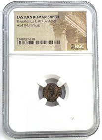
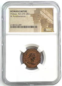
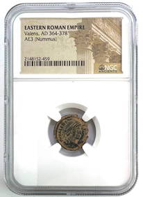
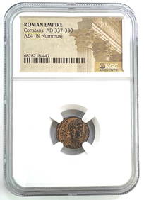
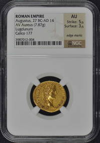
NGC Authentic Roman Empire Coin 1700+ Years oldMatthew Bullock Auctioneers4.7(1.8k)See Sold PriceFeb 24, 2024
NGC Authentic Roman Empire Coin 1700+ Years oldMatthew Bullock Auctioneers4.7(1.8k)See Sold PriceFeb 24, 2024
NGC Authentic Roman Empire Coin 1700+ Years oldMatthew Bullock Auctioneers4.7(1.8k)See Sold PriceFeb 24, 2024
NGC Authentic Roman Empire Coin 1700+ Years oldMatthew Bullock Auctioneers4.7(1.8k)See Sold PriceFeb 24, 2024
MEDIEVAL EUROPEAN CONVERT’S CROSS NECKLACE, 9th-10th CENTURYJasper524.5(9.8k)See Sold PriceFeb 28, 2024
NORTHERN EUROPEAN CONVERT’S CROSS NECKLACE, 9th-10th CENTURYJasper524.5(9.8k)See Sold PriceFeb 28, 2024
SHARIF OMAR: (1932-2015)International Autograph Auctions Europe S.L.4.5(52)See Sold PriceMar 12, 2024
ANCIENT ROMAN EMPIRE MILLEFIORI GLASS PATELLA CUPAntique Arena Inc.4.5(852)See Sold PriceMar 09, 2024