ATLAS of ANTIENT GEOGRAPHY by SAMUEL BUTLER 1843John McInnis Auctioneers,LLC4.5(505)See Sold PriceFeb 24, 2024
18TH C. ANTIQUE MAP: FRENCH & INDIAN WAR, FRAMEDThomaston Place Auction Galleries4.4(394)See Sold PriceFeb 24, 2024
Rand McNally Railroad Map Cabinet w/ 21 Railroad MapsRail & Road Auctions4.6(165)See Sold PriceMar 08, 2024
Keith Haring - Ink on New York Map, Best Buddies, Inscribed, Signed, and DatedSapphire Auction Gallery4.1(67)See Sold PriceMar 02, 2024
LATE 17TH C. FRENCH MAP OF THE NEW WORLD BY ALEXIS-HUBERT JAILLOT (1632-1712)Thomaston Place Auction Galleries4.4(394)See Sold PriceFeb 24, 2024
Central Railroad of New Jersey Map of Sandy Hook Route-ca. 1903JM Hobby Supply and Railroad Artifact Auctions4.4(127)See Sold PriceFeb 24, 2024
Lot of Six Mixed Atlas Box Cars-HO Scale-New in BoxJM Hobby Supply and Railroad Artifact Auctions4.4(127)See Sold PriceFeb 25, 2024
Rand McNally/Santa Fe Railroad Map of Iowa-1912JM Hobby Supply and Railroad Artifact Auctions4.4(127)See Sold PriceFeb 24, 2024
NICOLAES VISSCHER (NETHERLANDS, 1618-1709) MAP OF THE NEW WORLDThomaston Place Auction Galleries4.4(394)See Sold PriceFeb 24, 2024
17TH C. WORLD MAP BY NICOLAES VISSCHER (NETHERLANDS, 1618-1709)Thomaston Place Auction Galleries4.4(394)See Sold PriceFeb 24, 2024
Lot of Six Mixed Atlas Cabooses-HO Scale-New in BoxJM Hobby Supply and Railroad Artifact Auctions4.4(127)See Sold PriceFeb 25, 2024
SoldState of Rhode Island Map by Caleb HarrisUnited States,C. 1795 Compiled from the Surveys and Observations of Caleb Harris and engraved by J. Smither.Frame ht. 21 3/4".Frame wd. 17 1/2"From the collection of Larry Cooley.See Sold Price
SoldMap of the State of Rhode Island; compiled from thMap of the State of Rhode Island; compiled from the Surveys and Observations of Caleb Harris, by Harding Harris. "J. Smither Sculpt." 1 1/4" tear on middle right not affecting map. browning. ss: 13 1/See Sold Price
SoldThree maps, colored engraved maps, the State ofThree maps, colored engraved maps, the State of Massachusetts, New Hampshire by Samuel Lewis 1813, Rhode Island by Caleb Harris. sight size: 14 1/4" x 9 3/4" to 14" x 19 1/4".See Sold Price
SoldMAP OF RHODE ISLANDcompiled from the surveys and observations of Caleb Harris, by Harding Harris, engraving, 15-1/2 x 11-1/2 in. (sight)See Sold Price
Engraving, Map of Rhode IslandEngraved by J. Smither, compiled from the Surveys and Observations of Caleb Harris. Sight size: 14"h x 9-1/2"w Property from the Estate of Ralph & Roberta Carpenter.See Sold Price
SoldThe State of Rhode Island 1796 Engraved Map from theThe State of Rhode Island 1796 Engraved Mapfrom the latest surveys, published by John Reid, New Yorkplate size: 16 3/4" x 12 3/4"Provenance: The Estate of Diana Atwood JohnsonSee Sold Price
Sold1796 State of Rhode Island Hand Colored MapNew York,Dated 1796 Map of the State of Rhode Island as updated by the latest surveys,1796, hand colored on laid paper, engraved for the American edition of Winterbothams America, published by John ReSee Sold Price
SoldPease and Niles Gazetteer of the States of ConnecPease and Niles Gazetteer of the States of Connecticut and Rhode Island, Hartford, 1813 Map.-- Dimensions: --- US Shipping charge: $20See Sold Price
Sold2 Tanner Maps- Rhode Island & ConnecticutMap- ''The State of Rhode Island from the Latest Surveys, 1796'' & ''Connecticut From the Best Authorities'' engraved by Benjamin Tanner, both from ''The American Atlas'', light stains in right cornerSee Sold Price
A Topographical Map of the State of Rhode Island andA Topographical Map of the State of Rhode Island and Providence Plantations, Surveyed Trigonometrically by James Stevens, Topographer and Civil Engineer, with Additions and Corrections By S.B. CushingSee Sold Price
SoldRoad Map of the State of Rhode Island and ProvidenceRoad Map of the State of Rhode Island and Providence Plantations, Compiled and Published by C.A. Pabodie & Son, Providence, RI, 1899, paper laid down on linen, hand colored, 28" x 34".See Sold Price
SoldUNITED STATES POLICE SHERIFF OBSOLETE BADGE LOTLot of seven obsolete police and sheriff's department badges. Includes Jefferson County, New York, Providence County, Rhode Island, Harris County, Texas, and Alexandria, VA Sheriff's Department JailerSee Sold Price
SoldRhode-Island And ConnecticutTitle/Content of Map: Rhode-Island And Connecticut Date: 1802 Cartographer: HARRIS, H. Size: 7.3X12.75 "H. Harris delinvt." From Morse's American Universal Geography. Professionally restored and laidSee Sold Price
SoldFramed Topographical Map of the State of Rhode IsFramed Topographical Map of the State of Rhode Island and Providence Plantations, after James Stevens, 1831, mounted on canvas, (toning, tears, losses, foxing), 44 x 27 3/4 in.See Sold Price
SoldSTEVENS, JAMES. A Topographical Map of the StaSTEVENS, JAMES. A Topographical Map of the State of Rhode Island and Providence Plantations. Hand-colored engraved wall map, 1120x740 mm; few cracks in paper without loss, marginal dampstaining bleediSee Sold Price
Sold3 Hand-Colored Engraved New England Maps3 hand-colored engraved New England maps including the states of Rhode Island, Vermont and New Hampshire. "Lon E. from Philada" on lower margin of all three. All most likely engraved by Joseph T. ScotSee Sold Price
Sold4 Maps: Bradford, (1838). Maine, NH, Vermont, RI.[United States/New England] 4 Maps. ++ MAINE. ++ NEW HAMPSHIRE. ++ VERMONT. ++ RHODE ISLAND. ++ Maps 7, 8, 9, and 12 from T. G. Bradford, “An Illustrated Atlas, Geographical, Statistical, And HistorSee Sold Price
SoldState of Rhode Island from the latest surveys 1796.John Reid & W. Winterbotham. from the American Atlas. New York: J. Reid, L. Wayland & C. Smith, 1796. Engraved Map with Orignal Hand-color in Outline. 19 1/4 x 15 3/4 inchesSee Sold Price
SoldAtlas Of The State Of Rhode Island And ProvidenceAtlas Of The State Of Rhode Island And Providence Plantations From Actual Surveys and Official Records, Compiled & Published By D.G. Beers & Co., Philadelphia, 1870, having brown cloth boards. Note: ASee Sold Price
Bryce, James 1881 Pair of Maps of USA East Coast"Middle States. New York, Pennsylvannia, New Jersey, Delaware and Maryland" and "New England States. Maine, New Hampshire, Vermont, Massachusetts, Rhode Island and Connecticut" Lithograph Maps PublishSee Sold Price
Bryce, James 1881 Pair of Maps of USA East Coast"Middle States. New York, Pennsylvannia, New Jersey, Delaware and Maryland" and "New England States. Maine, New Hampshire, Vermont, Massachusetts, Rhode Island and Connecticut" Lithograph Maps PublishSee Sold Price
SoldC.1908 Rhode Island Telephone & Road MapUnited States,Circa 1908 Accompanied by original chapter no.40 museum label stating "TELEPHONE AND ROAD MAP 1908". Marked "HELIOTYPE CO., BOSTON" at lower right. 37" x 29",PaperSee Sold Price
SoldMassachusetts Rhode Island Maine Antique Map LOTEstate collection lot of a total of 3 maps from the states of Delaware, Arkansas and Massachusetts & Rhode Island. All show details of noteworthy towns of the period with colored engraved accents. MeaSee Sold Price
SoldNautical Map / Sea Chart, #1211 MarthaDescription: Nautical Map / Sea Chart, United States East Coast, Rhode Island - Connecticut - New York, Block Island Sound and Approaces9th edition, dec 23/63 stamped CORRECTED ONLY FOR AIDS & HAZARDSSee Sold Price
1853 Colton's Railroad & Township Map of Massachusetts, Rhode Island, and ConnecticutRail & Road Auctions4.6(165)See Sold PriceMar 07, 2024
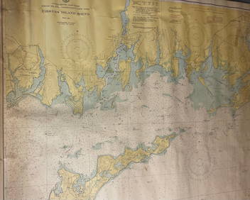
CHART: UNITED STATES - EAST COAST/ RHODE ISLAND - CONNECTICUT - NEW YORK/ Fishers IslandChurchill Galleries3.7(217)See Sold PriceFeb 26, 2024
2001-S Rhode Island State Quarter Gem Proof (Silver)Golden Air Auctions4.3(267)See Sold PriceFeb 26, 2024
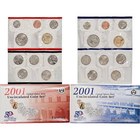
2001 20 piece United States Mint Set with Sacagawea Dollar in original Government packagingKey Date Coins4.4(1.4k)See Sold PriceFeb 25, 2024
2001 20 piece United States Mint Set with Sacagawea Dollar in original Government packagingKey Date Coins4.4(1.4k)See Sold PriceFeb 26, 2024
2001 20 piece United States Mint Set with Sacagawea Dollar in original Government packagingKey Date Coins4.4(1.4k)See Sold PriceFeb 26, 2024
2001 20 piece United States Mint Set with Sacagawea Dollar in original Government packagingKey Date Coins4.4(1.4k)See Sold PriceFeb 25, 2024
2001 20 piece United States Mint Set with Sacagawea Dollar in original Government packagingKey Date Coins4.4(1.4k)See Sold PriceFeb 27, 2024
2001 20 piece United States Mint Set with Sacagawea Dollar in original Government packagingKey Date Coins4.4(1.4k)See Sold PriceFeb 28, 2024
2001 20 piece United States Mint Set with Sacagawea Dollar in original Government packagingKey Date Coins4.4(1.4k)See Sold PriceFeb 29, 2024
2001 20 piece United States Mint Set with Sacagawea Dollar in original Government packagingKey Date Coins4.4(1.4k)See Sold PriceFeb 28, 2024
2001 20 piece United States Mint Set with Sacagawea Dollar in original Government packagingKey Date Coins4.4(1.4k)See Sold PriceFeb 27, 2024
2001 20 piece United States Mint Set with Sacagawea Dollar in original Government packagingKey Date Coins4.4(1.4k)See Sold PriceFeb 29, 2024
2001 20 piece United States Mint Set with Sacagawea Dollar in original Government packagingKey Date Coins4.4(1.4k)See Sold PriceFeb 27, 2024
2001 20 piece United States Mint Set with Sacagawea Dollar in original Government packagingKey Date Coins4.4(1.4k)See Sold PriceFeb 27, 2024
2001 20 piece United States Mint Set with Sacagawea Dollar in original Government packagingKey Date Coins4.4(1.4k)See Sold PriceFeb 28, 2024
2001 20 piece United States Mint Set with Sacagawea Dollar in original Government packagingKey Date Coins4.4(1.4k)See Sold PriceFeb 29, 2024
2001 20 piece United States Mint Set with Sacagawea Dollar in original Government packagingKey Date Coins4.4(1.4k)See Sold PriceFeb 28, 2024
2001 20 piece United States Mint Set with Sacagawea Dollar in original Government packagingKey Date Coins4.4(1.4k)See Sold PriceFeb 29, 2024