ATLAS of ANTIENT GEOGRAPHY by SAMUEL BUTLER 1843John McInnis Auctioneers,LLC4.6(502)See Sold PriceFeb 24, 2024
18TH C. ANTIQUE MAP: FRENCH & INDIAN WAR, FRAMEDThomaston Place Auction Galleries4.4(386)See Sold PriceFeb 24, 2024
Rand McNally Railroad Map Cabinet w/ 21 Railroad MapsRail & Road Auctions4.6(165)See Sold PriceMar 08, 2024
Keith Haring - Ink on New York Map, Best Buddies, Inscribed, Signed, and DatedSapphire Auction Gallery4(67)See Sold PriceMar 02, 2024
LATE 17TH C. FRENCH MAP OF THE NEW WORLD BY ALEXIS-HUBERT JAILLOT (1632-1712)Thomaston Place Auction Galleries4.4(386)See Sold PriceFeb 24, 2024
Central Railroad of New Jersey Map of Sandy Hook Route-ca. 1903JM Hobby Supply and Railroad Artifact Auctions4.4(126)See Sold PriceFeb 24, 2024
Lot of Six Mixed Atlas Box Cars-HO Scale-New in BoxJM Hobby Supply and Railroad Artifact Auctions4.4(126)See Sold PriceFeb 25, 2024
Rand McNally/Santa Fe Railroad Map of Iowa-1912JM Hobby Supply and Railroad Artifact Auctions4.4(126)See Sold PriceFeb 24, 2024
NICOLAES VISSCHER (NETHERLANDS, 1618-1709) MAP OF THE NEW WORLDThomaston Place Auction Galleries4.4(386)See Sold PriceFeb 24, 2024
17TH C. WORLD MAP BY NICOLAES VISSCHER (NETHERLANDS, 1618-1709)Thomaston Place Auction Galleries4.4(386)See Sold PriceFeb 24, 2024
Lot of Six Mixed Atlas Cabooses-HO Scale-New in BoxJM Hobby Supply and Railroad Artifact Auctions4.4(126)See Sold PriceFeb 25, 2024
Southeast Asia.- Spice Islands.- Jansson (Jan)Southeast Asia.- Spice Islands.- Jansson (Jan) Insularum Moluccarum Nova Descriptio, map of the Spice Islands, the cornerstone of the Dutch trading empire in the East Indies throughout the 17th CenturSee Sold Price
SoldSoutheast Asia.- Spice Islands.- Jansson (Jan)Asia.- Southeast Asia.- Spice Islands.- Jansson (Jan) Insularum Moluccarum Nova Descriptio, map of the Spice Islands, the cornerstone of the Dutch trading empire in the East Indies throughout the 17thSee Sold Price
SoldMAP, Southeast Asia, JanssonSoutheast Asia. Jan Jansson, Indiae Orientalis Nova Descriptio, 1647 (published). Hand Color. Decorative chart of the region including Indochina, the Philippines and the East Indies. This map is signiSee Sold Price
SoldORTELIUS, ABRAHAM. Indiae Orientalis, InsularumqueORTELIUS, ABRAHAM. Indiae Orientalis, Insularumque Adiacientium Typus. Double-page engraved map of southeast Asia and the Spice Islands. 15½x20¼ inches sheet size, ample margins, Latin textSee Sold Price
SoldSpice Islands Southeast Asia Antique MapSpice Islands Southeast Asia antique map. An early map of Italy. Loose, unframed and not glued or mounted, etc. m). Sheet size 18 3/4" x 24 3/4". Fair to good condition with tears in margin and paperSee Sold Price
20th C. Indonesian Moluccas Ancestral Marker w/ FinialSoutheast Asia, Indonesia, southeastern Malaku Islands (Moluccas/Spice Islands), ca. early 20th century CE. A massive carved wooden ancestral marker, made of two pieces - one, a long, canoe-shaped forSee Sold Price
20th C. Indonesian Malaku Islands Ancestral Marker**Originally Listed At $1500** Southeast Asia, Indonesia, southeastern Malaku Islands (Moluccas / Spice Islands), ca. early 20th century CE. A massive carved wooden ancestral marker, made of two pieceSee Sold Price
20th C. Indonesian Malaku Islands Ancestral MarkerSoutheast Asia, Indonesia, southeastern Malaku Islands (Moluccas / Spice Islands), ca. early 20th century CE. A massive carved wooden ancestral marker, made of two pieces - one, a long, canoe-shaped fSee Sold Price
Jansson Map of Spice Islands, 1641JANSSON, Jan (1588-1664). [Spice Islands] Insularum Moluccarum Nova Descriptio. Engraved map with original hand color. Amsterdam: c. 1641. 18" x 21 1/4" sheet. Fine example of Jansson's important andSee Sold Price
20th C. Indonesian Moluccas Ancestral Marker w/ FinialSoutheast Asia, Indonesia, southeastern Malaku Islands (Moluccas / Spice Islands), ca. early 20th century CE. A massive carved wooden ancestral marker, made of two pieces - one, a long, canoe-shaped fSee Sold Price
20th C. Indonesian Malaku Islands Ancestral MarkerSoutheast Asia, Indonesia, southeastern Malaku Islands (Moluccas / Spice Islands), ca. early 20th century CE. A massive carved wooden ancestral marker, made of two pieces - one, a long, canoe-shaped fSee Sold Price
20th C. Indonesian Malaku Islands Ancestral MarkerSoutheast Asia, Indonesia, southeastern Malaku Islands (Moluccas / Spice Islands), ca. early 20th century CE. A massive carved wooden ancestral marker, made of two pieces - one, a long, canoe-shaped fSee Sold Price
SoldSoutheast AsiaReserve Reduced! Title/Content of Map: Southeast Asia Date: 1598/99. Size: 11x9” Additional Info: Spice islands Malaysia. Philippines. By Ruscelli Venice Reserve: $275.00 Jasper52 negotiates the lowSee Sold Price
Jansson Map of the East Indies*** START PRICE IS THE RESERVE *** [Asia] JANSSON, Jan (1588-1664). Indiae Orientalis Nova Descriptio. Engraved map. Amsterdam, c. 1646. 18 1/8" x 21 1/2" sheet. Comparable: Arader Galleries, 2019 - $See Sold Price
SoldJanson Map of the East IndiesJansson, Jan (1588-1664). Indiae Orientalis Nova Descriptio. Engraved map with original color. Amsterdam, c. 1646. 18” x 21 1/4” sheet. Decorative chart of the Spice Islands region including IndocSee Sold Price
SoldJansson Map of the East Indian Ocean ArchipelagosJan Jansson (1588 - 1664), "Indiae Orientalis Nova Descriptio," Amsterdam, ca. 1630. This hand colored map depicts a section of Southeast Asia, including what is now Laos, Cambodia, Thailand, Vietnam,See Sold Price
SoldInsularum Moluccarum Nova DescriptioJan Jansson (1588-1664). Amsterdam, c.1641. Engraved map with original hand color. 18 x 21 1/4 inches. Fine example of Jansson’s important and highly decorative map of the Spice Islands. IndicativeSee Sold Price
SoldSeale (Richard William) (Asia) The PhilippinSeale (Richard William) (Asia) Plate VIII. The Philippin, Carolin, Molucka, and Spice Islands,the Philippines and islands of south-east Asia, engraved map sheet, revised and improved by Mr. BoSee Sold Price
Soldmap, Asia Minor, Jan JanssonFramed engraved map of Turkey, including Cyprus and the eastern Aegaen islands, ''Natolia, quae olim Asia Minor,'' 1636, by Jan Jansson (Dutch, 1588-1664), with ornate large title cartouche in the uppSee Sold Price
SoldSpice islands. (Indonesia, Malaysia, mainland S.ETitle/Content of Map: Spice islands. (Indonesia, Malaysia, mainland S.E Asia.) Date: 1576-1590. Cartographer: Porchelli Size: 8x12”. Provenance: Republic of Venice A Rare very early map to focus onSee Sold Price
SoldJansson. Tartaria Sive Magni Chami Imperium. c.1635.[Northern Asia] Jansson, Jan (Dutch, 1588-1664). "Tartaria Sive Magni Chami Imperium." Amsterdam, c.1635-1640s. Hand-colored double-page map showing Northern Asia from the Volga River to Manchuria. ThSee Sold Price
SoldVan Langren/ Van Linschoten: Map of SE Asia[Southeast Asia]. Jan Hugen van Linschoten (1563-1610). Exacta & Accuratia Delineatio Cum Orarum Maritarimarum Tum Etjam Locarum Terrestrium Quae In Regionibus China, Cauchinchina, Comboja Sive ChampaSee Sold Price
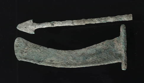
20th C. Bornean Iron, Rattan, & Wood Working AxeSoutheast Asia, island of Borneo, ca. mid 20th century CE. A hand-crafted utilitarian axe, used for clearing the dense jungles of Borneo. It features a sharp iron blade that slots into a notch in theSee Sold Price
20th C. Bornean Iron, Rattan, & Wood Working Axe**Originally Listed At $125** Southeast Asia, island of Borneo, ca. mid 20th century CE. A hand-crafted utilitarian axe, used for clearing the dense jungles of Borneo. It features a sharp iron blade tSee Sold Price
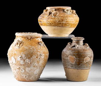
Antique Vietnamese Pottery Lime Pot Museum Quality 15th C.Auction Wallstreet4.5(47)See Sold PriceMar 02, 2024
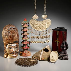
Burmese Bronze Jambupati Buddha & Indian Brass GaneshaArtemis Fine Arts4.8(1.4k)See Sold PriceFeb 26, 2024
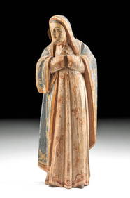
19th C. Filipino Spanish Colonial Santo - Virgin MaryArtemis Fine Arts4.8(1.4k)See Sold PriceFeb 26, 2024
SOUTHEAST ASIA MARANAO MOTHER OF PEARL WOODEN CHESTAntique Arena Inc.4.5(852)See Sold PriceJun 15, 2024