ATLAS of ANTIENT GEOGRAPHY by SAMUEL BUTLER 1843John McInnis Auctioneers,LLC4.5(505)See Sold PriceFeb 24, 2024
18TH C. ANTIQUE MAP: FRENCH & INDIAN WAR, FRAMEDThomaston Place Auction Galleries4.4(393)See Sold PriceFeb 24, 2024
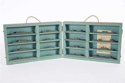
Rand McNally Railroad Map Cabinet w/ 21 Railroad MapsRail & Road Auctions4.6(165)See Sold PriceMar 08, 2024
Keith Haring - Ink on New York Map, Best Buddies, Inscribed, Signed, and DatedSapphire Auction Gallery4(67)See Sold PriceMar 02, 2024
LATE 17TH C. FRENCH MAP OF THE NEW WORLD BY ALEXIS-HUBERT JAILLOT (1632-1712)Thomaston Place Auction Galleries4.4(393)See Sold PriceFeb 24, 2024
Central Railroad of New Jersey Map of Sandy Hook Route-ca. 1903JM Hobby Supply and Railroad Artifact Auctions4.4(127)See Sold PriceFeb 24, 2024
Lot of Six Mixed Atlas Box Cars-HO Scale-New in BoxJM Hobby Supply and Railroad Artifact Auctions4.4(127)See Sold PriceFeb 25, 2024
Rand McNally/Santa Fe Railroad Map of Iowa-1912JM Hobby Supply and Railroad Artifact Auctions4.4(127)See Sold PriceFeb 24, 2024
NICOLAES VISSCHER (NETHERLANDS, 1618-1709) MAP OF THE NEW WORLDThomaston Place Auction Galleries4.4(393)See Sold PriceFeb 24, 2024
17TH C. WORLD MAP BY NICOLAES VISSCHER (NETHERLANDS, 1618-1709)Thomaston Place Auction Galleries4.4(393)See Sold PriceFeb 24, 2024
Lot of Six Mixed Atlas Cabooses-HO Scale-New in BoxJM Hobby Supply and Railroad Artifact Auctions4.4(127)See Sold PriceFeb 25, 2024
South Coast of Long Island, U.S. Coastal Survey 1857Domestic: Free Shipping Map Title: Middle Part of the South Coast of Long Island, U.S. Coastal Survey Date: 1857 Medium: Steelplate engraved chart Size: 34.5 x 24.5 inches Showing the topography of thSee Sold Price
1857 U.S. Coastal Survey Print Long IslandU.S. Coastal Survey Print, Middle Part of the Southern Coast of Long Island, published 1857, A.D. Bache, Superintendent, overall 28-3/4 x 38-1/2""See Sold Price
1857 U.S. Coastal Survey Print Long IslandU.S. Coastal Survey Print, Eastern Part of the Southern Coast of Long Island, published 1857, A.D. Bache, Superintendent, overall 30 x 38""See Sold Price
1857 U.S. Coastal Survey Print Long IslandU.S. Coastal Survey Print, Eastern Part of the Southern Coast of Long Island, published 1857, A.D. Bache, Superintendent, overall 30-3/4 x 39-1/2""See Sold Price
1851 U.S. Coastal Survey Print Long IslandU.S. Coastal Survey Print, Western Part of the Southern Coast of Long Island, published 1851, Aids to Navigation Corrected to 1888, R. Bache, lieutenant USN, A.S. Baldwin, lieutenant USN, & M. WoodhulSee Sold Price
1851 U.S. Coastal Survey Print Long IslandU.S. Coastal Survey Print, Western Part of the Southern Coast of Long Island, published 1851, Aids to Navigation Corrected to 1888, R. Bache, lieutenant USN, A.S. Baldwin, lieutenant USN, & M. WoodhulSee Sold Price
Sold1857 Coast survey chart of Long IslandDetailed chart showing the south coast of Long Island from Moriches Bay to East Hampton including Shinnecock Bay, Mecox Bay, Georgica Pond etc.. Also showing topographical detail of Bridgehampton, MilSee Sold Price
SoldFramed Chart of the Atlantic CoastFramed chart of the Atlantic coast from Cape Sable to Cape Hattaras from 1908 by the US Coastal Survey. Highlights include New Brunswick, Nova Scotia, Cape Cod, Martha's Vineyard, Long Island, NorfolkSee Sold Price
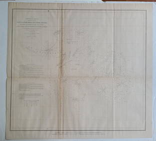
Five Views of Montauk Point LighthouseHassler, Ferdinand R. (1770-1843). Eastern Part of the Southern Coast of Long Island... Engraved map. U.S. Coast Survery, 1857. 24 â…" x 35" sheet. ... from a Trigonometrical survey under the direcSee Sold Price
Sold1857 Coast Survey Chart, St. Helena Sound, SC1857 chart by US Coast Survey, AD Bache Superintendent of St. Helena Sound, South Carolina. Showing from Fripps Island to Edistow Islands. Mounted into a black frame. Condition: good. 27 x 31See Sold Price
SoldCOPLEY, LONG ISLAND SOUND, ENGRAVING, C.1851Artist: Charles Copley, Title: Long Island Sound, Printmaker: Charles Copley, Pub: U.S. Coastal Survey, Date: C.1851, Medium: Engraving, Paper size: 9 x 19, Inscribed: Publisher, cartographer, and engSee Sold Price
Sold3-sheet chart of Long Island Sound 1855Title: Long Island Sound. Western Sheet [in set with] Middle Part of Long Island Sound [and] Eastern Part of Long Island Sound Author: U.S. Coast Survey Description: Together, 3 sheet forming one largSee Sold Price
Three US Coast Survey Map of Long Island RegionSketch B No. 3, showing the progressive changes in Sandy Hook from 1779 to 1853. Published Washington D.C. 1853, 12 x 11.5 inches. Folds as issued. Sketch B No 2. US Coast Survey of Romer and Flynns SSee Sold Price
Three US Coast Survey Map of Long Island RegionSketch B No. 3, showing the progressive changes in Sandy Hook from 1779 to 1853. Published Washington D.C. 1853, 12 x 11.5 inches. Folds as issued. Sketch B No 2. US Coast Survey of Romer and Flynns SSee Sold Price
Sold3 Coast Chart of Long Island SoundLong Island Sound... From a Trignometrical survey under the direction of F. R. Hassler and A. D. Bache Superintendents of the Survey Of The Coast Of The United States. U.S. Coast Survey. Washington, 1See Sold Price
SoldU.S. Coast Survey Map of South Farallon Island and San(lot of 2) Alexander Dallas Bache (American, 1806 - 1867), South Farallon Island, 1855, and San Clemente Island, 1856, U.S. Coast Survey hand-colored copper engraved maps, overalls (with frames): 18"hSee Sold Price
SoldU.S. Coast Survey 1853 Map of Long Island, New Jersey"Sketch B Showing the progress of Section No. 2" Electrotype Map Published 1843-65, Washington for "Report of the Superintendent of the U.S. Coast Survey..." Published under the supervision and directSee Sold Price
SoldChart of San Antonio Creek Oakland CA 1857Title: San Antonio Creek California. From a Trigonometrical Survey under the Direction of A.D. Bache, Superintendent of the Survey of the Coast of the United States Author: U.S. Coastal Survey DescripSee Sold Price
Eastern Part of Long Island Sound | Middle Part of LongPublication Date: 1855 Title: Eastern Part of Long Island Sound | Middle Part of Long Island Sound | Long Island Sound (Western Sheet) Cartographer: U.S. COAST SURVEY/F. R. HASSLER Publisher: GPO WestSee Sold Price
Long Island Sound (Western Sheet)Title/Content of Map: Long Island Sound (Western Sheet) Cartographer: U.S. COAST SURVEY/F. R. HASSLER Date: 1866 Publisher: GPO Size: 24.5Height - 35Width "Published in 1855" New York and ConnecticutSee Sold Price
Eastern Part of Long Island Sound | Middle Part of LongTitle/Content of Map: Eastern Part of Long Island Sound | Middle Part of Long Island Sound | Long Island Sound (Western Sheet) Cartographer: U.S. COAST SURVEY/F. R. HASSLER Date: 1855 Publisher: GPO SSee Sold Price
3-sheet chart of Lonng Island Sound 1855Heading: Author: U.S. Coast Survey Title: Long Island Sound... From a Trignometrical survey under the direction of F. R. Hassler and A. D. Bache Superintendents of the Survey Of The Coast Of The UnitSee Sold Price
Middle Part of the Southern Coast of Long Island...Publication Date: 1857 Title: Middle Part of the Southern Coast of Long Island... Cartographer: HASSLER, F.R. Publisher: U.S. COAST SURVEY Height: 24.5 Width: 34.5 ... from a Trigonometrical survey unSee Sold Price
United States - East Coast / Connecticut - New York Long Island Sound - Eastern PartDescription: United States - East Coast / Connecticut - New York Long Island Sound - Eastern Part. Published at Washington D. C. US COAST AND GEODETIC SURVEY.Material: PaperMeasurement approximate: 30See Sold Price
BOTH TITLE PAGES OF COLLINS" COASTAL SURVEY, 1776, IN MATCHING FRAMESThomaston Place Auction Galleries4.4(393)See Sold PriceFeb 24, 2024
CHART "SOUTHERN COAST OF LONG ISLAND FROM MONTAUK POINT TO EAST HAMPTON" Circa 1877 11.25" x 22.75"Eldred's4.7(419)See Sold PriceFeb 27, 2024
South Salem Studios, US Navy Ship Model CaseStefek's Auctioneers & Appraisers4.6(113)See Sold PriceFeb 28, 2024
1852 CHART SHOWING POSITIONS of DAVIS'S SOUTH SHOAL & OTHER DANGERS antiqueJasper524.5(9.9k)See Sold PriceFeb 27, 2024
Keuffel & Esser Co. Bronze Surveying InstrumentWorld Auction Gallery LLC4.7(264)See Sold PriceMar 10, 2024
Royal Copenhagen Porcelain "Flora Danica" CompoteWorld Auction Gallery LLC4.7(264)See Sold PriceMar 10, 2024
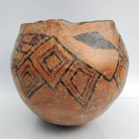
Zuni Pueblo, Native American Polychrome VaseWorld Auction Gallery LLC4.7(264)See Sold PriceMar 10, 2024
Cochiti Pottery Seed Jar by Terasita RomeroWorld Auction Gallery LLC4.7(264)See Sold PriceMar 10, 2024
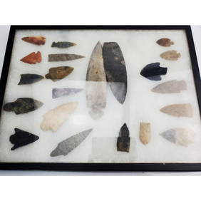
Display Box of Native American Spear & Arrow HeadsWorld Auction Gallery LLC4.7(264)See Sold PriceMar 10, 2024
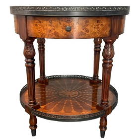
Theodore Alexander Inlaid Round Side TableWorld Auction Gallery LLC4.7(264)See Sold PriceMar 10, 2024
Pair of Mid Century Modern Blonde Wood ArmchairsWorld Auction Gallery LLC4.7(264)See Sold PriceMar 10, 2024
Chinese/Japanese Silver Mount Plique a Jour BowlsWorld Auction Gallery LLC4.7(264)See Sold PriceMar 10, 2024
Antique Korean Goryeo Dynasty Celadon Pottery BowlWorld Auction Gallery LLC4.7(264)See Sold PriceMar 10, 2024
Antique Chinese Enameled Imperial Porcelain Phoenix PlateWorld Auction Gallery LLC4.7(264)See Sold PriceMar 10, 2024