ATLAS of ANTIENT GEOGRAPHY by SAMUEL BUTLER 1843John McInnis Auctioneers,LLC4.6(502)See Sold PriceFeb 24, 2024
18TH C. ANTIQUE MAP: FRENCH & INDIAN WAR, FRAMEDThomaston Place Auction Galleries4.4(386)See Sold PriceFeb 24, 2024
Rand McNally Railroad Map Cabinet w/ 21 Railroad MapsRail & Road Auctions4.6(165)See Sold PriceMar 08, 2024
Keith Haring - Ink on New York Map, Best Buddies, Inscribed, Signed, and DatedSapphire Auction Gallery4(67)See Sold PriceMar 02, 2024
LATE 17TH C. FRENCH MAP OF THE NEW WORLD BY ALEXIS-HUBERT JAILLOT (1632-1712)Thomaston Place Auction Galleries4.4(386)See Sold PriceFeb 24, 2024
Central Railroad of New Jersey Map of Sandy Hook Route-ca. 1903JM Hobby Supply and Railroad Artifact Auctions4.4(126)See Sold PriceFeb 24, 2024
Lot of Six Mixed Atlas Box Cars-HO Scale-New in BoxJM Hobby Supply and Railroad Artifact Auctions4.4(126)See Sold PriceFeb 25, 2024
Rand McNally/Santa Fe Railroad Map of Iowa-1912JM Hobby Supply and Railroad Artifact Auctions4.4(126)See Sold PriceFeb 24, 2024
NICOLAES VISSCHER (NETHERLANDS, 1618-1709) MAP OF THE NEW WORLDThomaston Place Auction Galleries4.4(386)See Sold PriceFeb 24, 2024
17TH C. WORLD MAP BY NICOLAES VISSCHER (NETHERLANDS, 1618-1709)Thomaston Place Auction Galleries4.4(386)See Sold PriceFeb 24, 2024
Lot of Six Mixed Atlas Cabooses-HO Scale-New in BoxJM Hobby Supply and Railroad Artifact Auctions4.4(126)See Sold PriceFeb 25, 2024
South America Sheet II. Guayana and North BrazilTitle: South America Sheet II. Guayana and North Brazil Publication Date: 1836-10-01 Cartographer: WALKER, J. & C. Publisher: Baldwin & Cradock/S.D.U.K. Dimension: 12.2 X 15.75 Excellent topographicalSee Sold Price
South America Sheet II Guayana and North BrazilTitle/Content of Map: South America Sheet II Guayana and North Brazil Date Printed: 1836-10-01 Cartographer: WALKER, J. & C. Size: 12.5X15.3 Excellent topographical detail, roads, bays, capes, nativeSee Sold Price
South America Sheet II Guayana and North BrazilTitle/Content of Map: South America Sheet II Guayana and North Brazil Date Printed: 1850 ca. Cartographer: WALKER, J. & C. Size: 12.5X15.3 Excellent topographical detail, roads, bays, capes, native trSee Sold Price
SoldSchomburgk / SDUK: Guianas & Northern BrazilMap Title: South America Sheet II Guayana and North Brazil. Cartographer: Schomburgk & Dolango / Chapman & Hall Place / Date: London / 1836 Size: 15 1/2" x 12 1/4" Condition: outline color; light overSee Sold Price
AMAZONIA showing Indian tribes. Guyana, Surinam &TITLE/CONTENT OF MAP: 'SOUTH AMERICA, SHEET II., GUAYANA AND NORTH BRAZIL' The map shows the locations of native Indian tribes DATE PRINTED: 1874 IMAGE SIZE: Approx 34.5 x 43.0cm, 13.5 x 16.75 inchesSee Sold Price
Schomburgk / SDUK: Guianas & Northern BrazilMap Title: South America Sheet II Guayana and North Brazil. Cartographer: Schomburgk & Dolango / Chapman & Hall Place / Date: London / 1836 Size: 15 1/2" x 12 1/4" Condition: outline color; light overSee Sold Price
Schomburgk/SDUK: Guianas & Northern BrazilMap: South America Sheet II Guayana and North Brazil. Cartographer: Schomburgk & Dolango / Chapman & Hall Place/Date: London / 1836 Size: 15 1/2" x 12 1/4" Condition: outline color; light overall ageSee Sold Price
SoldSDUK: Antique Map of Amazonia, South America, 1846Title/Content of Map: 'SOUTH AMERICA, SHEET II., GUYANA AND NORTH BRAZIL' The map shows the locations of native Indian tribes and settlements. AMAZONIA. Showing Indian tribes. Guyana Surinam Brazil. RSee Sold Price
AMAZONIA. Showing Indian tribes. Guyana Surinam Brazil.TITLE/CONTENT OF MAP: 'SOUTH AMERICA, SHEET II., GUYANA AND NORTH BRAZIL' The map shows the locations of native Indian tribes and settlements Date: This map was originally published by Baldwin & CradoSee Sold Price
AMAZONIA showing "El Dorado?" & Missions. BrazilTITLE/CONTENT OF MAP: 'SOUTH AMERICA, SHEET I., ECUADOR, GRANADA, VENEZUELA AND PARTS OF BRAZIL AND GUAYANA' This fascinating map of the North West part of South America/Amazonia covers Ecuador, New GSee Sold Price
AMAZONIA showing "El Dorado?" & Missions. BrazilTITLE/CONTENT OF MAP: 'SOUTH AMERICA, SHEET I., ECUADOR, GRANADA, VENEZUELA AND PARTS OF BRAZIL AND GUAYANA' This fascinating map of the North West part of South America/Amazonia covers Ecuador, New GSee Sold Price
AMAZONIA showing "El Dorado?" & Missions. BrazilTITLE/CONTENT OF MAP: 'SOUTH AMERICA, SHEET I., ECUADOR, GRANADA, VENEZUELA AND PARTS OF BRAZIL AND GUAYANA' This fascinating map of the North West part of South America/Amazonia covers Ecuador, New GSee Sold Price
South America (North). Brazil Colombia Peru &c.TITLE/CONTENT OF MAP: 'South America (Northern Sheet) [inset: Galapagos Isles]' Date: 1879 IMAGE SIZE: Approx 47.5 x 61.5cm, 18.75 x 24.25 inches (Large); Please note that this is a folding map. TYPE:See Sold Price
South America (North). Brazil Colombia Peru &c.TITLE/CONTENT OF MAP: 'South America (Northern Sheet) [inset: Galapagos Isles]' DATE PRINTED: 1879 IMAGE SIZE: Approx 47.5 x 61.5cm, 18.75 x 24.25 inches (Large); Please note that this is a folding maSee Sold Price
SoldSouth America Sheet ITitle/Content of Map: South America Sheet I Date Printed: 1842-03-15 Cartographer: WALKER, J. & C. Size: 12.25X16.2 Ecuador, Granada, Venezuela, and parts of Brazil and Guayana. Shows a possible locatSee Sold Price
SoldSOUTH WESTERN USA.Showing Republic of Texas & MexicanReserve Reduced! TITLE/CONTENT OF MAP: 'CENTRAL AMERICA, SHEET II., INCLUDING TEXAS, CALIFORNIA AND THE NORTHERN STATES OF MEXICO' The map shows the Republic of Texas as an independent state as it exiSee Sold Price
SDUK: Antique Map of Amazonia, Brazil Ecuador 1846TITLE/CONTENT OF MAP: 'SOUTH AMERICA, SHEET I., ECUADOR, NEW GRANADA, VENEZUELA AND PARTS OF BRAZIL AND GUYANA' This fascinating map of the North West part of South America/Amazonia covers Ecuador, NeSee Sold Price
Chapman & Hall/SDUK: Guianas & North BrazilSchomburgk's map of northeastern South America from from English Guyana to Pernambuco from the General Atlas of the Society for the Diffusion of Useful Knowledge (see also Sheet I, item #33, above). LSee Sold Price
SoldAMAZONIA indicating "El Dorado?", missions & tribesTITLE/CONTENT OF MAP: 'SOUTH AMERICA, SHEET I., ECUADOR, NEW GRANADA, VENEZUELA AND PARTS OF BRAZIL AND GUYANA' This fascinating map of the North West part of South America/Amazonia covers Ecuador, NeSee Sold Price
SoldAMAZONIA.Showing "El Dorado?", missions & tribes.TITLE/CONTENT OF MAP: 'SOUTH AMERICA, SHEET I., ECUADOR, NEW GRANADA, VENEZUELA AND PARTS OF BRAZIL AND GUYANA' This fascinating map of the North West part of South America/Amazonia covers Ecuador, NeSee Sold Price
SDUK: Antique Map of Northwest South America, 1846Title/Content of Map: 'SOUTH AMERICA, SHEET I., ECUADOR, NEW GRANADA, VENEZUELA AND PARTS OF BRAZIL AND GUYANA' This fascinating map of the North West part of South America/Amazonia covers Ecuador, NeSee Sold Price
AMAZONIA.Showing "El Dorado?", missions & tribes.TITLE/CONTENT OF MAP: 'SOUTH AMERICA, SHEET I., ECUADOR, NEW GRANADA, VENEZUELA AND PARTS OF BRAZIL AND GUYANA' This fascinating map of the North West part of South America/Amazonia covers Ecuador, NeSee Sold Price
South America Sheet III South Brazil With Paraguay andTitle/Content of Map: South America Sheet III South Brazil With Paraguay and Uraguay Date: c1850 Cartographer: WALKER, J. & C. Size: 15.5Height - 13.5Width Publisher: CHARLES KNIGHT & CO./S.D.U.K. MapSee Sold Price
SDUK: Antique Map of South Brazil, 1846Title/Content of Map: 'SOUTH AMERICA, SHEET III., SOUTH BRAZIL WITH PARAGUAY AND URUGUAY' The map includes some interesting brief anecdotes, eg "The Mate chiefly cultivated around Villa Rica" Bahia MiSee Sold Price
LARGE EARLY 18TH C. DUTCH CHART OF UPPER NORTH AMERICA, PIERRE MORTIER (1661-1711), FRAMEDThomaston Place Auction Galleries4.4(386)See Sold PriceFeb 24, 2024
5 Dollars - Elizabeth II Map of North AmericaWeatherham Estate Treasures3.9(157)See Sold PriceMar 07, 2024
The Rolling Stones Bridges To Babylon Tour Original Promotional PosterShakespeare Auctions4.3(1)See Sold PriceFeb 25, 2024
1932 Germany LZ127 Graf Zeppelin South America Flight Cover Danzig to Rio BrazilMynt Auctions4.6(680)See Sold PriceFeb 27, 2024
4 3/16" Ancient Inca Stone Mace. South America. Motley COATony Putty Artifacts4.7(404)See Sold PriceMar 09, 2024
Carey, pub. 1796 - Map of the Tennassee State formerly part of North Carolina (Tennessee)Trillium Antique Prints & Rare Books4.5(30)See Sold PriceFeb 24, 2024
Map: An 18thC engraved and hand coloured map of North America and South America, titled DeClaydon Auctioneers Ltd4.3(125)See Sold PriceFeb 26, 2024
1822 MAP of NORTH & SOUTH AMERICA GEOGRAPHICAL STATISTICAL HISTORICAL antiqueJasper524.5(9.8k)See Sold PriceFeb 27, 2024
Blackie (Pub) 1882 Folio Print. Aborigines of South America. Brazil Patogonia Tierra del FuegoAlbion Auctions4.6(336)See Sold PriceMar 07, 2024
Mexico, Central America and West Indies Physical PoliticalJasper524.5(9.8k)See Sold PriceFeb 27, 2024
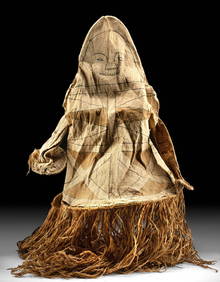
20th C. South American Bark Cloth Body Mask (for Tawu)Artemis Fine Arts4.8(1.4k)See Sold PriceFeb 26, 2024
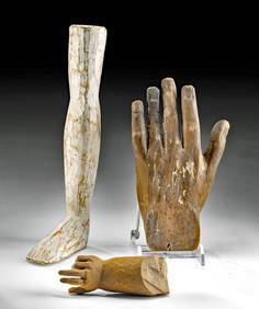
Early 20th C. Brazilian Milagro Wood Leg + Two HandsArtemis Fine Arts4.8(1.4k)See Sold PriceFeb 26, 2024
Six boxed 1:72 scale limited edition die-cast models of WWII American bombers by Corgi Aviation ...Bonhams4.1(305)See Sold PriceMar 01, 2024
Large Fossilized Tortoise Shell - Stylemys NebraskensisArtemis Fine Arts4.8(1.4k)See Sold PriceMar 01, 2024
Gems / Minerals: Agate, Tourmaline & Aquamarine (12)Artemis Fine Arts4.8(1.4k)See Sold PriceMar 01, 2024