ATLAS of ANTIENT GEOGRAPHY by SAMUEL BUTLER 1843John McInnis Auctioneers,LLC4.6(502)See Sold PriceFeb 24, 2024
18TH C. ANTIQUE MAP: FRENCH & INDIAN WAR, FRAMEDThomaston Place Auction Galleries4.4(386)See Sold PriceFeb 24, 2024
Rand McNally Railroad Map Cabinet w/ 21 Railroad MapsRail & Road Auctions4.6(165)See Sold PriceMar 08, 2024
Keith Haring - Ink on New York Map, Best Buddies, Inscribed, Signed, and DatedSapphire Auction Gallery4(67)See Sold PriceMar 02, 2024
LATE 17TH C. FRENCH MAP OF THE NEW WORLD BY ALEXIS-HUBERT JAILLOT (1632-1712)Thomaston Place Auction Galleries4.4(386)See Sold PriceFeb 24, 2024
Central Railroad of New Jersey Map of Sandy Hook Route-ca. 1903JM Hobby Supply and Railroad Artifact Auctions4.4(126)See Sold PriceFeb 24, 2024
Lot of Six Mixed Atlas Box Cars-HO Scale-New in BoxJM Hobby Supply and Railroad Artifact Auctions4.4(126)See Sold PriceFeb 25, 2024
Rand McNally/Santa Fe Railroad Map of Iowa-1912JM Hobby Supply and Railroad Artifact Auctions4.4(126)See Sold PriceFeb 24, 2024
NICOLAES VISSCHER (NETHERLANDS, 1618-1709) MAP OF THE NEW WORLDThomaston Place Auction Galleries4.4(386)See Sold PriceFeb 24, 2024
17TH C. WORLD MAP BY NICOLAES VISSCHER (NETHERLANDS, 1618-1709)Thomaston Place Auction Galleries4.4(386)See Sold PriceFeb 24, 2024
Lot of Six Mixed Atlas Cabooses-HO Scale-New in BoxJM Hobby Supply and Railroad Artifact Auctions4.4(126)See Sold PriceFeb 25, 2024
Johnson: Map of South America, 18631863 Johnson Map of South America -- Johnson's South America. A very nice map of South America, richly detailed with color coded political subdision, settlements and topography. Patagonia is shown asSee Sold Price
SoldJohnson: Antique Map of South America, 1863Map: 1863 Johnson Map of South America -- Johnson's South America Cartographer: Johnson & Ward Year / Place: 1863, New York Map Dimensions: 22 x 16 in. Condition: Very good. Nicely colored. Slight tonSee Sold Price
South America by Johnson 1868Map Title: South America Maker: Johnson Date: 1868 Publisher: Alvin J. Johnson & Co.: New York Size: 18 x 26 inches From Johnson's Atlas of the World Map details cities, towns, and territories. No ResSee Sold Price
South America by JohnsonTitle: South America by Johnson Date/Period: 1861 Materials: Steel engraved. Size: 26 1/2 x 18” By A. J. Johnson & J. H Colton. From "Johnson's New Illustrated Family Atlas' published in New York. SSee Sold Price
1861 South America by JohnsonTitle: 1861 South America by Johnson Date/Period: 1861 Materials: Steel engraved. Size: 26 1/2 x 18” By A. J. Johnson & J. H Colton. From "Johnson's New Illustrated Family Atlas' published in New YoSee Sold Price
SoldGrp: 17 Books on European Exploration of South AmGroup of seventeen books about European exploration of South America. Adrian Johnson, "America Explored," Four copies; Attributed to Edward Ward, "The Facmile Text Society series I: Language and LiterSee Sold Price
Johnson's South AmericaTitle: Johnson's South America Prublication Date: 1864 Cartographer: JOHNSON, ALVIN JEWETT Publisher: JOHNSON & WARD Size: 22.25Height - 15.75Width Additional Information: Map showing entire continentSee Sold Price
Soldlot of 2 antique maps - a hand colored "Johnson'slot of 2 antique maps - a hand colored "Johnson's South America 1863" published by Johnson & Ward - 22 1/2"x16" & a an early black & white of the Mediterranean area - 13 1/2" x 18"See Sold Price
Sold1863 JOHNSON'S MAP OF SOUTH AMERICAPublished by Johnson and Ward, dated 1863, 23.5 x 17.5 inches. Not examined outside of plastic wrap, appears excellent.See Sold Price
Sold9 book plate maps9 book plate maps including Dominion of Canada and Newfoundland; Johnson's Roman Empire; South America. Foxing; tears; creases. Largest measures 27 inches x 18 inches.See Sold Price
SoldFRED JOHNSON FALABELLA HORSE FROM SOUTH AMERICAImage of Gaucho with miniature horse, promoted as 28" tall. Light use wear. 96" x 116"See Sold Price
SoldSouth America: 11 color maps, 1850s-1870s[Latin America]. 11 Color Maps from 19th century atlases. 10 of portions of South America, 1 Central America. From Mithcell, Johnson, and Cowperthwait atlases, mostly 1850s-1860s, one map H. H. MigeonSee Sold Price
Sold"JohnsonLarge, fantastic, collector's book full of (frameable) color and black and white maps and illustrations of North America, South America, Europe, and Africa. Most maps intact and in good condition, a fSee Sold Price
SoldA. J. Johnson, "Comparative Heights of Mountains, andA. J. Johnson, "Comparative Heights of Mountains, and Lengths of Rivers in Africa, Asia, Europe, South America, North America," hand colored, 1864, 26 3/8 in., W.- 18 1/8 in.See Sold Price
SoldTHREE MAPS OF SOUTH AMERICA (VENEZUELA-PATAGONIA)Includes an unmatted Johnson and Ward 1863 map of 'Venezuela, New Granada, Ecuador, Peru and Bolivia, Chile and Guiana,' 14 x 18 inches. An 1836 map of 'Venezula, New Grenada and Equador,' professionaSee Sold Price
Sold"Johnson's Chart of Comparative Heights of Mountains"Johnson's Chart of Comparative Heights of Mountains and Lengths of Rivers of Africa, Asia, Europe, South America and North America," 1864, presented in a gilt frame, H.- 23 3/4 in., W.- 17 in.See Sold Price
SoldTwo Maps by Johnson & Ward, "West Indies," 1864, handTwo Maps by Johnson & Ward, "West Indies," 1864, hand colored, H.- 17 7/8 in., W.- 26 1/2 in.; together with "South America," 1860, hand colored, H.- 26 1/2 in., W.- 18 1/4 in. (2 Pcs.)See Sold Price
SoldThe History of North South America, From Its DiscoveryThe History of North South America, From Its Discovery to the Death of General Washington, Two Volumes bound in one book, Philadelphia: Johnson & Warner, 1809. Hardbound, full leather. 8vo. Two foldinSee Sold Price
SoldMap of South America, 1868Original engraving from Johnson's Atlas of the World, 1868. Map details cities, towns and territories. Dimensions: 18" x 26". This item ships from Ocean View, DE.See Sold Price
Sold1864 Johnson Chart of Mountains and Rivers perTitle: 1864 Johnson Chart of Mountains and Rivers per Continent -- Johnson's Chart of Comparative Heights of Mountains and Lengths of Rivers of Africa, Asia, Europe, South America and North America CaSee Sold Price
SoldMap of South America #59631Double truck, 73,74. Engraved Cartography with hand color by A.J. Johnson. Vivid color. This shows Panama railroad for gold region bound pioneers. Many gold rush bound pioneers traveled from the eastSee Sold Price
Sold(18) 19th Century Johnson's & London News MapsTo include Johnson's hand colored maps of China, Palestine, France, Holland, Belgium, Roman Empire, South America, Turkey & Arabia, New Brunswick & Newfoundland, Australia, Brazil, Agentine, ParaguaySee Sold Price
SoldHistory of North and South America for Children NewberyHeading: Author: Cooper, Rev. Mr. [pseud. Richard Johnson] Title: The History of North [South] America Place Published: London Publisher:E. Newbery Date Published: 1789 Description: </See Sold Price
1858 Map of Northern South AmericaTitle: 1858 Map of Northern South America Medium: Ink on Paper Dimensions: 18"X14.5" Map of the Northern part of South America all the way to Argentina dated 1858. Printed by A.J. Johnson. Map captureSee Sold Price
1.3/4" Pre Columbian Head, Pottery, South AmericaHeartland Artifact Auctions Inc4.7(780)See Sold PriceFeb 25, 2024
5.5/16" Pre Columbian Pottery Figurine, Painted Red, South AmericaHeartland Artifact Auctions Inc4.7(780)See Sold PriceFeb 25, 2024
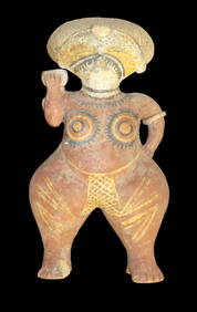
Large Human Effigy Pottery Vessel, Nicely Painted, Pre Columbian Pottery Vessle, South America. 14"Heartland Artifact Auctions Inc4.7(780)See Sold PriceFeb 25, 2024
Hand Crafted / Painted Pottery Dish Signed by "Callen Eldui La Serena Chile" South America PotteryHeartland Artifact Auctions Inc4.7(780)See Sold PriceFeb 25, 2024
1 1/2" Pre Columbian Pottery Face Effigy Head Mayan Aztec found in South AmericaHeartland Artifact Auctions Inc4.7(780)See Sold PriceFeb 25, 2024
4 3/16" Ancient Inca Stone Mace. South America. Motley COATony Putty Artifacts4.7(404)See Sold PriceMar 09, 2024
Collection 60 pages stamps South America and America 18-1900sBazaar of Persia4.3(23)See Sold PriceFeb 24, 2024
Map: An 18thC engraved and hand coloured map of North America and South America, titled DeClaydon Auctioneers Ltd4.3(125)See Sold PriceFeb 26, 2024
1822 MAP of NORTH & SOUTH AMERICA GEOGRAPHICAL STATISTICAL HISTORICAL antiqueJasper524.5(9.8k)See Sold PriceFeb 27, 2024
Early Pre-Colombian Obsidian Knife, found in South AmericaHeartland Artifact Auctions Inc4.7(780)See Sold PriceMar 10, 2024
7" Jade Pre-Colombian Tirona Batwing Gorget, 2000 Yrs Old, found in Tirona Colombia South America,Heartland Artifact Auctions Inc4.7(780)See Sold PriceMar 10, 2024
5" Olmec God Effigy Pre-Colombian Pendant, South AmericaHeartland Artifact Auctions Inc4.7(780)See Sold PriceMar 10, 2024
9 3/4 Porphyry Pre-Colombian Spud, South AmericaHeartland Artifact Auctions Inc4.7(780)See Sold PriceMar 10, 2024
3 1/2" Pre-Colombian Obsidian Gorget, South AmericaHeartland Artifact Auctions Inc4.7(780)See Sold PriceMar 10, 2024
5" Pre-Colombian Obsidian 3-sided Dagger, South AmericaHeartland Artifact Auctions Inc4.7(780)See Sold PriceMar 10, 2024
2 1/4" Pre-Colombian Human Jade Effigy, South AmericaHeartland Artifact Auctions Inc4.7(780)See Sold PriceMar 10, 2024
1 3/4" Pre-Colombian Obsidian Core South AmericaHeartland Artifact Auctions Inc4.7(780)See Sold PriceMar 10, 2024
Blackie (Pub) 1882 Folio Print. Aborigines of South America. Brazil Patogonia Tierra del FuegoAlbion Auctions4.6(336)See Sold PriceMar 07, 2024
6" Jade Pre-Colombian Tirona Batwing Gorget, 2000 Yrs Old, found in Tirona Colombia South America,Heartland Artifact Auctions Inc4.7(780)See Sold PriceMar 10, 2024