Sold1840 Society for the Diffusion of Useful Knowledge map1840 Society for the Diffusion of Useful Knowledge map of New York City- 12” x 15” matSee Sold Price
SoldSociety for the Diffusion of Useful Knowledge MapSociety for the Diffusion of Useful Knowledge Engraved, Hand-Colored Map, depicting lower Arkansas, lower Louisiana, Mississippi and Alabama, second quarter 19th century, published as sheet XIII, presSee Sold Price
SoldSDUK [Maps]Society for the Diffusion of Useful Knowledge. [Maps],145 engraved maps and plans (of 218), comprising 112 map sheets, and 33 town plans, one double-page, 3 folding, the majority with originalSee Sold Price
SoldItaly.- SDUK [Maps]Society for the Diffusion of Useful Knowledge, [Maps], 9 engraved city plans, with some original hand-colouring, each c.310 x 380mm., several with engraved vignettes (uncoloured), some browninSee Sold Price
SoldSDUK mapsSociety for the Diffusion of Useful Knowledge [Maps], approximately 108 engraved maps, 20 city plans and 6 star charts, the majority with original outline hand-colouring, from the above work,See Sold Price
SoldDavies (Benjamin Rees) LondonDavies (Benjamin Rees) London,from Archway to The Oval, and from Kensington Gardens to Blackwall, for the Society for the Diffusion of Useful Knowledge, engraved map with full original hand-coSee Sold Price
SoldSDUK 1841 Map of the WorldSociety for the Diffusion of Useful Knowledge, 1841, Map of the World, engraving, with some border coloring, "The World on Mercator's Projection" tears and toning primarily in margin, map size 15.25"See Sold Price
Sold[SDUK] Maps of the Society for the Diffusion of U[SDUK] Maps of the Society for the Diffusion of Useful Knowledge,[SDUK] Maps of the Society for the Diffusion of Useful Knowledge, 2 vol., 161 engraved maps hand-coloured in outline, a few folSee Sold Price
SoldCelestial.- SDUK (Society for the Diffusion of UsefulCelestial.- SDUK (Society for the Diffusion of Useful Knowledge) Six Maps of The Stars, title, 2 pp. of explanation, and six celestial charts, engraved by J. & C. Walker, each chart's sheet approx. 38See Sold Price
Sold4Pcs Maps Of Africa SDUK C1840 Chart Whig PublicationDetails: 4Pcs SDUK (Society for the Diffusion of Useful Knowledge). [4 MAPS OF AFRICA] Africa; West Africa I; West Africa II; South Africa. London: Charles Knight & Co., Undated: c. 1840. Sheet size:See Sold Price
West Africa I.Title: West Africa I. Date: 1839-04-01 Cartographer: WALKER, J. & C. Publisher: SOCIETY FOR THE DIFFUSION OF USEFUL KNOWLEDGE/S.D.U.K. Description: Map showing the region of Africa immediately south oSee Sold Price
S.D.U.K Antique Map of AfricaDescription: Beautiful example of an 1831 Society for the Diffusion of Useful Knowledge or S.D.U.K. map of Africa. This map was originally published by Baldwin and Cradock and copyrighted in 1831, butSee Sold Price
Antique Map of Islands in the Atlantic by Baldwin andAntique map Islands of the Atlantic. This map was originally published by Baldwin and Cradock and copyrighted and published 1836 Society for the Diffusion of Useful Knowledge or S.D.U.K. map of the IsSee Sold Price
Empire of Japan from SDUK c.1840Title: Empire of Japan Author: Society for the Diffusion of Useful Knowledge Description: Engraved map, hand-colored in outline. Engraved by J. & C. Walker. 39x32 cm. (15½x12½").Detailed map of JapaSee Sold Price
Empire of Japan from SDUK c.1840Title: Empire of Japan Author: Society for the Diffusion of Useful Knowledge Description: Engraved map, hand-colored in outline. Engraved by J. & C. Walker. 39x32 cm. (15½x12½").Detailed map of JapaSee Sold Price
SoldAtlas.- Maps Of The Society For The Diffusion OfMaps Of The Society For The Diffusion Of Useful Knowledge,84 engraved maps and town plans, only, of 96, with 6 star charts, from vol. 2, with outline hand-colouring, 325 x 300mm., several witSee Sold Price
SoldSDUK Central America with independent Texas 1842Title: Central America II. Including Texas, California and the Northern States of Mexico Author: Society for the Diffusion of Useful Knowledge Description: Steel-engraved map, hand-colored in outline.See Sold Price
S.D.U.K. Maps of the Society for the Diffusion ofS.D.U.K. Maps of the Society for the Diffusion of Useful Knowledge,2 vol, 210 maps and plans including 3 double-page world maps, folding double-page map of Ireland, 45 single-page city plans aSee Sold Price
SDUK map of Venice c.1840Title: Venice. Venezia. Venedig Author: Society for the Diffusion of Useful Knowledge Description: Steel-engraved map, hand-colored. On two sheets joined together. 38x59 cm. (15x23¼").One of the mostSee Sold Price
SoldMap of North America from S.D.U.K. 1843Title: North America Author: Society for the Diffusion of Useful Knowledge Description: Steel-engraved map, hand-colored in outline. Engraved by J. & C. Walker. 38.5x30.5 cm. (15¼x12"). Well-engravedSee Sold Price
SoldSDUK map of World RiversTitle: A Map of the Principal Rivers Shewing their Courses, Countries, and Comparative Lengths Author: Society for the Diffusion of Useful Knowledge Description: Steel-engraved map. 39x32 cm. (15½x12See Sold Price
SDUK map of Venice c.1840Title: Venice. Venezia. Venedig Author: Society for the Diffusion of Useful Knowledge Description: Steel-engraved map, hand-colored. On two sheets joined together. 38x59 cm. (15x23¼").One of the mostSee Sold Price
Maps of the Society for the Diffusion of Useful KnMaps of the Society for the Diffusion of Useful Knowledge,2 vol., 145 maps hand-coloured in outline only (of 152, vol.1 lacking 2 Mercator's Projection, 2 Ancient World, Europe general, AsiaSee Sold Price
SoldAtlases.- SDUK (Society for the Diffusion of UsefulAtlases.- SDUK (Society for the Diffusion of Useful Knowledge) [The Family Atlas], 71 maps only, including Sir Roderick Murchison's Geological map of England and Wales, 5 celestial charts, and 3 foldiSee Sold Price
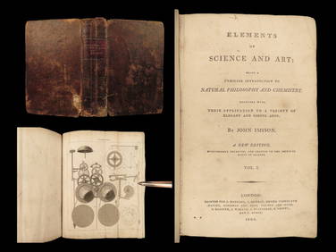
1803 Imison Science & Art Steam Engines Optics Electricity CLOCKS IllustratedSchilb Antiquarian Rare Books4.8(428)See Sold PriceMar 31, 2024
1855 Guide for the Pennsylvania Railroad with an Extensive Map from the Pennsylvania RailroadRail & Road Auctions4.6(165)See Sold PriceMar 07, 2024
Group of Ten Railroad Photographs, Maps, and Prints - New Jersey, Long Island, and New YorkRail & Road Auctions4.6(165)See Sold PriceMar 07, 2024
David Hockney "Useful Knowledge" Custom Gallery Framed PrintMynt Auctions4.6(697)See Sold PriceFeb 25, 2024
Map: A 19thC engraved and hand coloured map of South America. Published by the Society for theClaydon Auctioneers Ltd4.3(125)See Sold PriceFeb 26, 2024
Africa inc. discoveries of Livingstone Barth Vogel Chadda Exp. SWANSTON 1860 mapJasper524.5(9.9k)See Sold PriceFeb 28, 2024
NIGERIA early explorers' routes. Lake Chad. Yariba Houssa Borgou SDUK 1844 mapJasper524.5(9.9k)See Sold PriceFeb 28, 2024
Central Africa. Map showing great forest traversed by Mr Stanley, 1890Jasper524.5(9.9k)See Sold PriceFeb 28, 2024
NIGERIA w/ early explorers' routes. Lake Chad Yariba Houssa Borgou.SDUK 1844 mapJasper524.5(9.9k)See Sold PriceFeb 28, 2024
1792 OLD INDIA HISTORY ANTIQUE ILLUSTRATED WITH MAPS OF THE EIGHTEENTH CENTURY IN FRENCHNY Elizabeth 4.2(86)See Sold PriceMar 03, 2024
Jacques Nicolas Bellin - Antique Map - Vue de la Rade de Tiniam, double antique coast view of theProverde Auctions4.3(3)See Sold PriceFeb 28, 2024


![SDUK [Maps] (1 of 1)](https://p1.liveauctioneers.com/410/16866/5604905_1_x.jpg?height=282&quality=70&version=1220278581)
![Italy.- SDUK [Maps] (1 of 1)](https://p1.liveauctioneers.com/410/3027/1300264_1_x.jpg?height=282&quality=70)


![[SDUK] Maps of the Society for the Diffusion of U (1 of 1)](https://p1.liveauctioneers.com/410/22377/7776635_1_x.jpg?height=282&quality=70)