Timetable, Paper and Ephemera Lot-Eastern USA RailroadsJM Hobby Supply and Railroad Artifact Auctions4.4(126)See Sold PriceFeb 24, 2024
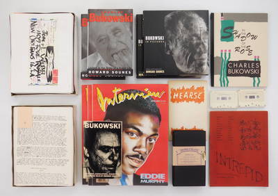
[BASEBALL]. Group of Varied Ephemera, including: Sporting L...Potter & Potter Auctions4.6(539)See Sold PriceMar 07, 2024
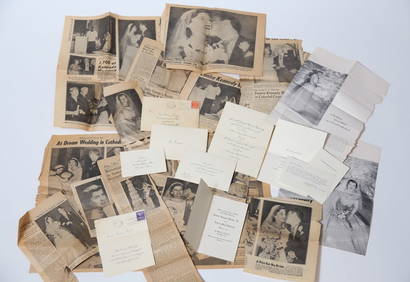
EPHEMERA from the MARRIAGE of MS. EUNICE KENNEDYJohn McInnis Auctioneers,LLC4.6(502)See Sold PriceFeb 25, 2024
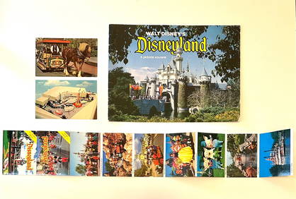
Rare Lot of 1965 and 1977 Walt Disneyland Collectible EphemeraSouth Florida Auction & Estate Sale Services Inc4.5(520)See Sold PriceMar 08, 2024
[CIGARETTE CARDS AND TOBACCO EPHEMERA]. A Group of Six Coll...Potter & Potter Auctions4.6(539)See Sold PriceMar 07, 2024
Group of MLB Ticket and Passes, Other Ephemera: American League Annual PassDana J. Tharp Auctions4.7(268)See Sold PriceFeb 24, 2024
Group of US Presidents inauguration souvenirs, and EphemeraMatthew Bullock Auctioneers4.7(1.8k)See Sold PriceFeb 24, 2024
Smartsville and Colombo Mine Maps, 3 [166830]2 reproduction Smartsville maps 19x19". 1930 Colombo Mine, Sierra City map 24,52, a few small tears and stain. Please inspect. CaliforniaSee Sold Price
SoldBrohier, ANCIENT IRRIGATION WORKS IN CEYLON, 1979[Ceylon]. R.L. Brohier. Ancient Irrigation Works In Ceylon. 3 Vols in 1. (Colombo: Ministry of Mahaweli Development, 1979) reprint of 1934 edition. Tall Folio. vi,37;iv,43;viii,77pp. Includes 25 mapsSee Sold Price
Sold9 Items: Virginia, 1800's. 6 Maps + 3 Illus.[Virginia]. 9 Items (6 Maps & 3 Illustrations). Largest: 11 1/8” x 13 ¾” at inner border. Smallest: 5 x 3 ¾” at border. Good to very good, some with foxing and/or toning, some with small penciSee Sold Price
Sold4 FRAMED MAPS, 3 ANTIQUE & 1 CONTEMPORARYREGNO DI FRANCIA D.1776, 16" X 12"; PROVINCE OF NEW YORK, 1776, COPY, SIGHT 26 ½" X 21";NORTH AFRICA, SIGHT 14 ½" X 19"; ENGRAVING OF ANCIENT TOWNSCAPE 12" X 18 ½"See Sold Price
SoldFRENCH MAPS [3] V. LEVASSEUR, ATLAS ILLUSTREFRENCH MAPS [3] 12" X 17" V. LEVASSEUR, ATLAS ILLUSTRE: Three maps. Visible paper size: 12" x 17". Framed size: 16" x 22". Hand colored. Region du Nord No 26 and No 28. Also Region du Sud No 14. One mSee Sold Price
SoldLewis and Clark Trail Maps, 3 vols.Heading: (Lewis & Clark Expedition) Author: Plamondon, Martin Title: Lewis and Clark Trail Maps: a Cartographic Reconstruction Place Published: Pullman, Washington Publisher:Washington State UniversitSee Sold Price
SoldJOE COLOMBO (3)Tre lampade da parete mod. Flash. Alluminio smaltato, materiale plastico. Produzione Oluce anni '60. cm 32x17x18 Buone condizioni generali, piccoli graffi e leggeri segni di usura. GOOD GENERAL CONDITSee Sold Price
Sold[America, Maps] 3 city maps, about 1910SCARCE EDITIONS OF EARLY 1900 OF THREE HANDY MAPS OF USA CITIES (NEW YORK, PHILADELPHIA AND NEW ORLEANS) [1.]: Rand, McNally Co.. New handy map of New York City with a large scale map of the borough oSee Sold Price
Sold4 TN & KY Maps, 3 Framed1st item: "Tennessee" Map, by Anthony Finley, engraved by Young and Delleker, published by Anthony Finley, Philadelphia, 1824. From "A New General Atlas, Comprising a Complete Set of Maps" by AnthonySee Sold Price
SoldMilitary World War 2 103rd Evacuation Hospital Maps (3)Two maps, measures 27 1/2th" x 20", comes with original mailing stamped tube, in good condition for age.See Sold Price
SoldVintage Montana Maps (3)Three vintage Montana maps. They measure 11-in. x 17-in. to 15.25-in. x x22.75-in. VG-EX/EX condition. Unframed, loose and not glued or mounted. If lot is absent of a condition report a condition repoSee Sold Price
Sold[ARABIC MAPS]. 3 manuscript maps from unknown[ARABIC MAPS]. 3 manuscript maps from unknown work, ca.late 19th century. Text in Farsi on front and verso. Margins lightly soiled, occasional foxing and few other defects, sold as is. ++ Map of the wSee Sold Price
AMERICAN MAPS, 3, 17-19TH C. VIRGINIA/FLORIDA"AMERICAN MAPS, 3, 17-19TH C., VIRGINIA/FLORIDA, 13"" X 19"", 2 MAPS OF AMERICA, 16"" X 21"" & 14"" X 19"":Virginia & Florida is hand colored, 13 1/4"" x 19 1/8"", text on verso, appears to be unsigneSee Sold Price
16TH C. MAPS 3: ASIA, 14" X 19", EUROPE,"16TH C. MAPS 3: ASIA, 14"" X 19"", EUROPE, 13"" X 18"" & AFRICA, 15"" X 19"", THREE:All hand colored, marked in pencil in lower right margin, ""Ortelius Anvers 1579"", appear to be unsigned and are uSee Sold Price
Sold5 Maps: 3 of NY, 2 others.[United States/NY/Navigation]. 5 Maps. Sold with all faults. ++ A Plan of the City and Environs of New York as they were in the Years 1742_1743 and 1744. Drawn by D….G…. in the 76th year of his agSee Sold Price
SoldANTIQUE MAPS, 3, WH LIZARS, EDINBURGH 15" X 19"ANTIQUE MAPS, 3, W.H. LIZARS, EDINBURGH, 15" X 19", C 1850:Unframed. Each map in two sections. 18" x 21 1/2" sheet size. Image 15 1/2 x 19 1/4". Published by W Lizars, Edinburgh. Samuel Highley, FleetSee Sold Price
SoldSet of Framed 19th C. Relief Maps (3)Printed in Chicago, 1893, set includes a framed relief map of the United States, a relief map of Europe, and a relief map of the world, 27" x 37 1/2" sight, 34" x 47 1/2" framed.See Sold Price
SoldPA/NJ/DE map + 3 editions of MD/DE map.[Maryland/Pennsylvania]. 4 Maps. ++ A New Map Of Maryland And Delaware...Phila: S. Augustus Mitchell, c.1846. Margins browned. Table of distances, inset of Baltimore. ++ A New Map Of Maryland And DelaSee Sold Price
Sold[MAP]. 3 maps, US Topo. Engineers. [1848][MAP]. Three maps produced by the U.S. Topographical Engineers showing aspects of the last battles in Mexico. All are lithographs with later, expert hand color and are first editions. All are from MesSee Sold Price
SoldWWII U.S. ARMY AIR FORCE SILK MAPS (3)3 silk maps including 1) Two 1945 34" x 32" maps of Japan and South China one one side and the East China Sea on the reverse, 2) a 1943 36" x 31.5" map of Timor Southwest Pacific area on one side andSee Sold Price
[MAPS] 3 Maps by Girolamo Ruscelli.[MAPS] 3 Maps by Girolamo Ruscell sold together, Including: RUSCELLI, Girolamo. DELLA GEOGRAFIA DI TOLOMECO. TABVLA ASAI III. 25 x 32 cm, [1599] ** RUSCELLI, Girolamo. DELLA GEOGRAFIA DI TOLOMECO. TABSee Sold Price
Monin, V 1833 Maps (3) Alger, Guyane, Sengal. Africa3 French Colony Maps. One of French Guiana, the others North and West Africa. Steel Engraved Maps Published 1833, Paris for "Petit Atlas National des départements de la France et de ses colonies" bySee Sold Price
DUNLEVIE c1856 Map Counties Of Gaspe & Bonaventure Quebec Canada SCARCE! #1Luis Porretta Fine Arts4.3(10)See Sold PriceMar 02, 2024
LI XIONGCAI'S EXQUISITE PAPER-BASED LANDSCAPE MAP VERTICAL AXISMega International Auction4.3(62)See Sold PriceFeb 24, 2024
United States Map with American Flag 3-D Wall Mount PaintingWeatherham Estate Treasures3.9(157)See Sold PriceFeb 29, 2024
1938 American Armies and Battlefields by the American Battle Monuments CommissionNorth American Artifact Auctions4.6(182)See Sold PriceApr 20, 2024
Chatelain - 3 Maps of the British Isles (England, Ireland, Scotland)Trillium Antique Prints & Rare Books4.5(30)See Sold PriceFeb 24, 2024
1675 ELZEVIER JULIUS CAESAR antique ILLUSTRATED w/ MAPS ROMAN HISTORYJasper524.5(9.8k)See Sold PriceFeb 27, 2024
1856 ARCTIC EXPLORATIONS 2nd GRINNEL EXPEDITION 2 v. E.KANE antique ILLUSTRATEDJasper524.5(9.8k)See Sold PriceFeb 27, 2024
1738 BIBLE in DUTCH ILLUSTRATED w/ MAPS antique MASSIVE FOLIO BIBLIAJasper524.5(9.8k)See Sold PriceFeb 27, 2024
Emory's Notes of a Military Reconnoissance larger issuePBA Galleries4.7(381)See Sold PriceMar 07, 2024
Set of 3 Maps - Netherlands - Belgien - Switzerland - J. BarlowProverde Auctions4.3(3)See Sold PriceFeb 28, 2024
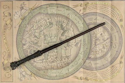
Universal Studios Harry Potter Wand BRapid Estate Liquidators and Auction Gallery4.5(1.1k)See Sold PriceFeb 28, 2024


![Smartsville and Colombo Mine Maps, 3 [166830] First Image](https://p1.liveauctioneers.com/2699/299063/159201942_1_x.jpg?height=282&quality=95&version=1692045182&width=282)

![Smartsville and Colombo Mine Maps, 3 [166830] First Image](https://p1.liveauctioneers.com/2699/299063/159201942_1_x.jpg?height=282&quality=1&version=1692045182&width=282)
![[BASEBALL]. Group of Varied Ephemera, including: Sporting L... (1 of 2)](https://p1.liveauctioneers.com/928/318880/171361366_1_x.jpg?height=282&quality=70&version=1707501302)
![[CIGARETTE CARDS AND TOBACCO EPHEMERA]. A Group of Six Coll... (1 of 1)](https://p1.liveauctioneers.com/928/318880/171361529_1_x.jpg?height=282&quality=70&version=1707501302)


![Smartsville and Colombo Mine Maps, 3 [166830] (1 of 2)](https://p1.liveauctioneers.com/2699/299063/159201942_1_x.jpg?height=282&quality=70&version=1692045182)


![FRENCH MAPS [3] V. LEVASSEUR, ATLAS ILLUSTRE (1 of 2)](https://p1.liveauctioneers.com/359/44582/19848039_1_x.jpg?height=282&quality=70&version=1377883298)


![[America, Maps] 3 city maps, about 1910 (1 of 10)](https://p1.liveauctioneers.com/2198/56199/31005028_1_x.jpg?height=282&quality=70&version=1415833748)


![[ARABIC MAPS]. 3 manuscript maps from unknown (1 of 3)](https://p1.liveauctioneers.com/179/10971/2682680_1_x.jpg?height=282&quality=70&version=1162265652)


![[MAP]. 3 maps, US Topo. Engineers. [1848] (1 of 6)](https://p1.liveauctioneers.com/514/95447/48676200_1_x.jpg?height=282&quality=70&version=1477936208)

![[MAPS] 3 Maps by Girolamo Ruscelli. (1 of 1)](https://p1.liveauctioneers.com/1124/187577/94719449_1_x.jpg?height=282&quality=70&version=1607095126)