ATLAS of ANTIENT GEOGRAPHY by SAMUEL BUTLER 1843John McInnis Auctioneers,LLC4.5(505)See Sold PriceFeb 24, 2024
18TH C. ANTIQUE MAP: FRENCH & INDIAN WAR, FRAMEDThomaston Place Auction Galleries4.4(394)See Sold PriceFeb 24, 2024
Rand McNally Railroad Map Cabinet w/ 21 Railroad MapsRail & Road Auctions4.6(165)See Sold PriceMar 08, 2024
Keith Haring - Ink on New York Map, Best Buddies, Inscribed, Signed, and DatedSapphire Auction Gallery4.1(67)See Sold PriceMar 02, 2024
LATE 17TH C. FRENCH MAP OF THE NEW WORLD BY ALEXIS-HUBERT JAILLOT (1632-1712)Thomaston Place Auction Galleries4.4(394)See Sold PriceFeb 24, 2024
Central Railroad of New Jersey Map of Sandy Hook Route-ca. 1903JM Hobby Supply and Railroad Artifact Auctions4.4(127)See Sold PriceFeb 24, 2024
Lot of Six Mixed Atlas Box Cars-HO Scale-New in BoxJM Hobby Supply and Railroad Artifact Auctions4.4(127)See Sold PriceFeb 25, 2024
Rand McNally/Santa Fe Railroad Map of Iowa-1912JM Hobby Supply and Railroad Artifact Auctions4.4(127)See Sold PriceFeb 24, 2024
NICOLAES VISSCHER (NETHERLANDS, 1618-1709) MAP OF THE NEW WORLDThomaston Place Auction Galleries4.4(394)See Sold PriceFeb 24, 2024
17TH C. WORLD MAP BY NICOLAES VISSCHER (NETHERLANDS, 1618-1709)Thomaston Place Auction Galleries4.4(394)See Sold PriceFeb 24, 2024
Lot of Six Mixed Atlas Cabooses-HO Scale-New in BoxJM Hobby Supply and Railroad Artifact Auctions4.4(127)See Sold PriceFeb 25, 2024
Sketch Map of the Public Surveys in Wisconsin, 1856Map: Sketch of the Public Surveys in Wisconsin Publisher: General Land Office/A.O.P. Nicholson, Warner Lewis, 1856 Size: Folio – 17.50 H x 21.25 W Inches "and Territory of Minnesota." Folding map deSee Sold Price
SoldSketch of the Public Surveys in Wisconsin and TerritoryTitle/Content of Map: Sketch of the Public Surveys in Wisconsin and Territory of Minnesota Cartographer: LEWIS, WARNER Date: 1855 Publisher: SURVEYOR GENERALS' OFFICE Size: 17Height - 21Width SurveyorSee Sold Price
Map of Wisconsin & Territory of Minnesota, 1854Map: A Sketch of the Public Surveys in Wisconsin and Territory of Minnesota Maker: General Land Office, Lewis, Warner Publisher: General Land Office 1854 Washington, DCSize: Folio – 17.50 H x 20.75See Sold Price
(No. 1.) Sketch of the Public Surveys in Wisconsin.Title/Content of Map: (No. 1.) Sketch of the Public Surveys in Wisconsin. Date: 1856 Cartographer: LEWIS, WARNER Publisher: GENERAL LAND OFFICE Size: 17.3Height - 21.5Width Folding map depicting the sSee Sold Price
G Sketch of the Public Survey in Michigan.Title/Content of Map: G Sketch of the Public Survey in Michigan. Publication Date: 1856-10-23 Cartographer: CHAPMAN, LEANDER Publisher: SURVEYOR GENERAL'S OFFICE Description: Scale 18 miles to the incSee Sold Price
Sketch of the Public Surveys in the State of WisconsinMap: Sketch of the Public Surveys in the State of Wisconsin Date: 1866 Cartographer: WILSON, JOS./COMMISSIONER Publisher: G.L.O./DEPT. OF THE INTERIOR Size (inches): 17.3x16 Rare hand colored G.L.O. mSee Sold Price
(No. 1) Sketch of the Public Surveys in the State ofTitle/Content of Map: (No. 1) Sketch of the Public Surveys in the State of Wisconsin and Territory of Minnesota Publication Date: 1857 Cartographer: EMERSON, CHARLES L. Publisher: SURVEYOR GENERAL DesSee Sold Price
Sketch of the Public Surveys in Wisconsin.Publication Date: 1858 Title: Sketch of the Public Surveys in Wisconsin. Cartographer: LEWIS, WARNER Publisher: GENERAL LAND OFFICE Height: 17 Width: 18 Folding map depicting the state with only GreenSee Sold Price
(No. 1.) Sketch of the Public Surveys in Wisconsin.Title: (No. 1.) Sketch of the Public Surveys in Wisconsin. Date: 1856 Cartographer: LEWIS, WARNER Size: 17.3Height - 21.5Width Publisher:GENERAL LAND OFFICE Additional Info:Folding map depicting the sSee Sold Price
(No. 1.) Sketch of the Public Surveys in Wisconsin andTitle: (No. 1.) Sketch of the Public Surveys in Wisconsin and Territory of Minnesota Date: 1854 Cartographer: LEWIS, WARNER Publisher: GENERAL LAND OFFICE Size: 17.5Height - 20.75Width Folding map depSee Sold Price
SoldCollection of 12 U.S. state survey maps 1856-90'sTitle: Collection of 12 U.S. state survey maps Author: ** Description: With: Map of the Public Surveys in California. 36¼x30¾". Splits, white sticker repairs on verso. 1856. * Sketch of the Public SSee Sold Price
SoldCollection of 12 U.S. state survey maps 1856-90'sTitle: Collection of 12 U.S. state survey maps Author: ** Description: With: Map of the Public Surveys in California. 36¼x30¾". Splits, white sticker repairs on verso. 1856. * Sketch of the Public SSee Sold Price
Sold(No.1) Sketch of the Public Surveys of the State OfTitle: (No.1) Sketch of the Public Surveys of the State Of Wisconsin and State Of Minnesota... Publication Date: 1863 Cartographer: WILTSE, HENRY A. Publisher: SURVEYOR GENERALS OFFICE Brief DescriptiSee Sold Price
Sketch of the Public Surveys in the State of WisconsinTitle: Sketch of the Public Surveys in the State of Wisconsin and State Of Minnesota Publication Date: 1861 Cartographer: SURVEYOR GENERAL'S OFFICE Publisher: SURVEYOR GENERAL'S OFFICE, DUBUQUE Size:See Sold Price
Early Survey Map of New MexicoHeading: (New Mexico) Author: Pelham, William Title: Sketch of Public Surveys in New Mexico, to Accompany Report of Surveyor General 1856 Place Published: Washington Publisher: Date Published: </See Sold Price
T Sketch of Public Surveys in New Mexico.1856 Title: T Sketch of Public Surveys in New Mexico. Cartographer: PELHAM, WILLIAM Publisher: SURVEYOR GENERAL'S OFFICE Height: 22.25 Width: 32.75 "To accompany report of surveyor general 1856" LocatSee Sold Price
SoldMAP "SKETCH OF PUBLIC SURVEYS IN NEW MEXICO", 1860Unframed map, "Sketch of Public Surveys in New Mexico, 1860", A.P. Wilbar, Surveyor General of New Mexico, includes portions of areas identified as California, Utah, Kansas, identifies locations of InSee Sold Price
SoldSketch of the Public Surveys in Wisconsin and TerritorySurveyed platted plats copied descriptive lists made and field notes recorded and transcribed. Black ink on cream color paper. Slightly frayed at left edge. 19.25" x 24.5". Date: 1855 State/Country: WSee Sold Price
"Sketch of the Public Surveys in Wisconsin and"Sketch of the Public Surveys in Wisconsin and Territory of Minnesota,"1854, H. -18 7/8 in., W. - 22 1/2 in.See Sold Price
Sold(MAP) Sketch of Public Survey New Mexico, 1862, 21 1/2(MAP) Sketch of Public Survey New Mexico, 1862, to accompany the Annual Report of the Surveyor General for 1862. Private land claims and Pueblo Indian Grants surveyed, townships subdivided, shows miniSee Sold Price
Sketch of Public Surveys in California 1860.Title/Content of Map: Sketch of Public Surveys in California 1860. Date: 1860 Cartographer: WILBAR, A. P. Publisher: SURVEYOR GENERAL'S OFFICE Size: 23Height - 32.25Width Settled areas in plats. SomeSee Sold Price
Sketch of Public Surveys in New Mexico...Title/Content of Map: Sketch of Public Surveys in New Mexico... Cartographer: PELHAM, WM. Date: 1857 Publisher: SURVEYOR GENERAL OF NEW MEXICO/C.B. GRAHAM LITH. Size: 20Height - 30.5Width Shows sparseSee Sold Price
Sketch of Public Surveys in New Mexico...Title/Content of Map: Sketch of Public Surveys in New Mexico... Cartographer: CLARK, JOHN A. Date: 1862 Publisher: SURVEYOR GENERAL OF NEW MEXICO Size: 21Height - 28Width Map of New Mexico showing itSee Sold Price
Sketch of Public Surveys in New Mexico to Accompany theTitle/Content of Map: Sketch of Public Surveys in New Mexico to Accompany the Annual Report of the Surveyor General for 1862 Date: 1862 Cartographer: CLARK, JOHN A. Publisher: SURVEYOR GENERAL Size: 2See Sold Price
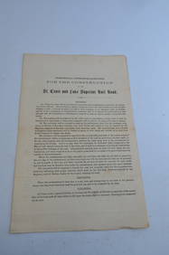
St Croix and Lake Superior RR General Specifications for Construction Document-1856JM Hobby Supply and Railroad Artifact Auctions4.4(127)See Sold PriceFeb 24, 2024
Kenyons Pocket Map and Shippers Guide of Wisconsin-1914JM Hobby Supply and Railroad Artifact Auctions4.4(127)See Sold PriceFeb 24, 2024
Thirty Pieces of Lackawanna Railroad Ephemera - Chief Engineer Timebook, Map, Public Timetables,Rail & Road Auctions4.6(165)See Sold PriceMar 07, 2024
Group of New York Central Railroad Paper - Rule Books, Employee Timetables, Stationary, Log Books,Rail & Road Auctions4.6(165)See Sold PriceMar 07, 2024
[JUNEAU, Solomon (1793-1856), association]. Land Deed for J...Potter & Potter Auctions4.6(550)See Sold PriceMar 07, 2024
William Simpson's Sketches at the Seat of War - Two Volumes with 81 Hand-colored LithographsTrillium Antique Prints & Rare Books4.5(33)See Sold PriceFeb 24, 2024
Nottingham.- Ordnance Survey Office (publisher) Collection 8 geological maps on the environs ofForum Auctions4.4(54)See Sold PriceFeb 29, 2024
INDIA WITHIN THE GANGES SUSAN GOLE ILLUSTRATED MAPS EARLY CARTOGRAPHYJasper524.5(9.9k)See Sold PriceFeb 27, 2024
Perry, Matthew C. 1856 Large Map. Shah Bay, Lew Chew I. JapanAlbion Auctions4.7(341)See Sold PriceMar 01, 2024
[Constructivism]. The general plan of reconstruction of Moscow. - Moscow: Moscow Worker, 1936. -ARTMAXIMUM4.3(4)See Sold PriceMar 14, 2024


![[JUNEAU, Solomon (1793-1856), association]. Land Deed for J... (1 of 2)](https://p1.liveauctioneers.com/928/318880/171361009_1_x.jpg?height=282&quality=70&version=1707501302)


![[Constructivism]. The general plan of reconstruction of Moscow. - Moscow: Moscow Worker, 1936. - (1 of 6)](https://p1.liveauctioneers.com/6171/320219/172084257_1_x.jpg?height=282&quality=70&version=1708525949)


