ATLAS of ANTIENT GEOGRAPHY by SAMUEL BUTLER 1843John McInnis Auctioneers,LLC4.6(504)See Sold PriceFeb 24, 2024
18TH C. ANTIQUE MAP: FRENCH & INDIAN WAR, FRAMEDThomaston Place Auction Galleries4.4(389)See Sold PriceFeb 24, 2024
Rand McNally Railroad Map Cabinet w/ 21 Railroad MapsRail & Road Auctions4.6(165)See Sold PriceMar 08, 2024
Keith Haring - Ink on New York Map, Best Buddies, Inscribed, Signed, and DatedSapphire Auction Gallery4.1(67)See Sold PriceMar 02, 2024
LATE 17TH C. FRENCH MAP OF THE NEW WORLD BY ALEXIS-HUBERT JAILLOT (1632-1712)Thomaston Place Auction Galleries4.4(389)See Sold PriceFeb 24, 2024
Central Railroad of New Jersey Map of Sandy Hook Route-ca. 1903JM Hobby Supply and Railroad Artifact Auctions4.4(126)See Sold PriceFeb 24, 2024
Lot of Six Mixed Atlas Box Cars-HO Scale-New in BoxJM Hobby Supply and Railroad Artifact Auctions4.4(126)See Sold PriceFeb 25, 2024
Rand McNally/Santa Fe Railroad Map of Iowa-1912JM Hobby Supply and Railroad Artifact Auctions4.4(126)See Sold PriceFeb 24, 2024
NICOLAES VISSCHER (NETHERLANDS, 1618-1709) MAP OF THE NEW WORLDThomaston Place Auction Galleries4.4(389)See Sold PriceFeb 24, 2024
17TH C. WORLD MAP BY NICOLAES VISSCHER (NETHERLANDS, 1618-1709)Thomaston Place Auction Galleries4.4(389)See Sold PriceFeb 24, 2024
Lot of Six Mixed Atlas Cabooses-HO Scale-New in BoxJM Hobby Supply and Railroad Artifact Auctions4.4(126)See Sold PriceFeb 25, 2024
Sketch Showing the Progress of the Survey in SectionTitle: Sketch Showing the Progress of the Survey in Section No.VI (Lower Sheet) from Key West to Cape Romano ... June 30, 1889 Publication Date: 1889 Cartographer: U.S. COAST AND GEODETIC SURVEY PubliSee Sold Price
Sketch Showing the Progress of the Survey in SectionTitle/Content of Map: Sketch Showing the Progress of the Survey in Section No.Xi (Upper Sheet) from Tillamook Bay to The Boundary ... June 30, 1889 Date: 1889 Cartographer: U.S. COAST SURVEY Size: 28HSee Sold Price
Sketch Showing the Progress of the Survey in SectionTitle: Sketch Showing the Progress of the Survey in Section No.X (Middle Sheet) from Pt. Sal to Tomales Bay Publication Date: 1889 Cartographer: U.S. COAST AND GEODETIC SURVEY Publisher: U.S. C. & G.SSee Sold Price
USCGS: Antique Survey Map of New England, 1889United States Coast and Geodetic survey sketch showing the progress of the survey in sections 1&2 Inset maps of St. Croix River and N.E. Boundary; sketch showing the progress of the survey in SectionSee Sold Price
Maritime Chart, U.S. Coast Survey, San Diego To PtCHART. U.S. Coast Survey, Sketch showing the progress of the survey in Section no. X, (lower sheet), from San Diego to Pt. Sal, from 1850-1877, scale 600.000, 1877, good condition, folds, 29 1/2" T xSee Sold Price
U.S. Coast Survey From San Diego to Pt. Sal. 1875.EARLY CALIFORNIA CHART. U.S. Coast Survey, Sketch showing the progress of the survey in Section no. X, (lower sheet), from San Diego to Pt. Sal, from 1850-1877, scale 600.000, 1877, good condition, foSee Sold Price
USCGS: Antique Survey Map of US Atlantic Coast, 1889United States Coast and Geodetic survey sketch showing the progress of the survey in sections 3&4 June 30, 1888' USA ATLANTIC COAST:Chesapeake & Delaware Bay.Cape Fear & Lookout Date Printed: 1889 ImaSee Sold Price
Sketch F showing the progress of the survey in SectionTitle/Content of Map: Sketch F showing the progress of the survey in Section No. VI from Cape Florida to Tortugas Islands from 1845 to 1861 Date: 1861 Publisher: U.S. Coast Survey Size: 19.8Height - 3See Sold Price
... Sketch I Showing the Progress of the Survey in Section No.Ix [Gulf Coast of Texas]Publication Date: 1860 Title: ... Sketch I Showing the Progress of the Survey in Section No.Ix [Gulf Coast of Texas] Cartographer: U.S. COAST SURVEY Publisher: U.S. COAST SURVEY Height: 10 Width: 24.7See Sold Price
Sketch I Showing the Progress of the Survey in SectionTitle: Sketch I Showing the Progress of the Survey in Section No.9 [Texas Gulf Coast] Cartographer: ANONYMOUS Publication Date: 1853 Publisher: U.S. COAST SURVEY Size: 17.5Height - 21.6Width TriangulaSee Sold Price
Sketch F Showing the Progress of the Survey in SectionTitle: Sketch F Showing the Progress of the Survey in Section VI (Lower Sheet) from Cape Florida to Tortugas Islands from 1845 to 1860... Cartographer: U.S. COAST SURVEY Date: 1860 Publisher: U.S. COASee Sold Price
Sketch a Showing the Progress of the Survey in SectionTitle: Sketch a Showing the Progress of the Survey in Section No. 1 Date: 1851 Cartographer: BACHE, A.D. Publisher: U.S. COAST SURVEY Size: 35.5Height - 22.8Width Map showing triangulation from MaineSee Sold Price
Sketch C Showing the Progress of the Survey in SectionPublication Date: 1851 Title: Sketch C Showing the Progress of the Survey in Section III from 1843 to 1851 Cartographer: BACHE, A.D. Publisher: U.S. COAST SURVEY Height: 32.75 Width: 20 Map showing trSee Sold Price
Sketch G Showing the Progress of the Survey in SectionTitle: Sketch G Showing the Progress of the Survey in Section No. VII [Florida Gulf Coast] from 1849 to 1857 Publication Date: 1857 Cartographer: U.S. COAST SURVEY Publisher: U.S. COAST SURVEY Height:See Sold Price
Sketch G Showing the Progress of the Survey in SectionTitle: Sketch G Showing the Progress of the Survey in Section VII from 1849 to 1860. Publication Date: 1861 Cartographer: U.S. COAST SURVEY Publisher: GPO Height: 21 Width: 34.75 The Florida Gulf CoasSee Sold Price
Sketch C Showing the Progress of the Survey in SectionPublication Date: 1853 Title: Sketch C Showing the Progress of the Survey in Section III [Chesapeake Bay] Cartographer: U.S. COAST SURVEY Publisher: U.S. COAST SURVEY Height: 32.5 Width: 22.6 Map showSee Sold Price
Sketch F. Showing the Progress of the Survey in SectionTitle: Sketch F. Showing the Progress of the Survey in Section No. VI Lower Sheet from Cape Florida to Tortugas Islands Publication Date: 1861 Cartographer: BACHE, A.D. Publisher: U.S. COAST SURVEY BrSee Sold Price
Sketch F Showing the Progress of the Survey in SectionTitle/Content of Map: Sketch F Showing the Progress of the Survey in Section Vi With a General Reconnoissance of The Western Coast Of Florida 1848-55 Publication Date: 1855 Cartographer: U.S. COAST SUSee Sold Price
Sketch G Showing the Progress of the Survey in SectionTitle/Content of Map: Sketch G Showing the Progress of the Survey in Section No. VII Cartographer: PIERCE, BENJAMIN Date: 1873 Publisher: U.S. COAST SURVEY Size: 21.5Height - 35.5Width Very large charSee Sold Price
Sketch F. Showing the Progress of the Survey in SectionTitle: Sketch F. Showing the Progress of the Survey in Section No. VI Lowest Sheet from Cape Florida to Tortugas Islands Date: 1860 Cartographer: BACHE, A.D. Publisher: U.S. COAST SURVEY Size: 20HeighSee Sold Price
Sketch E Showing the Progress of the Survey in SectionTitle/Content of Map: Sketch E Showing the Progress of the Survey in Section No. V ... 1866 Date Printed: 1869 Cartographer: U.S. COAST SURVEY Size: 15X20 Details triangulation, coastline, towns, poinSee Sold Price
Sketch E. Showing the Progress of the Survey in SectionTitle: Sketch E. Showing the Progress of the Survey in Section No. V. Publication Date: 1873 Cartographer: BACHE, A.D. Publisher: U.S. COAST SURVEY Size: 21.3 X 36 Additional Information: Detailing thSee Sold Price
Sketch F Showing the Progress of the Survey in SectionTitle: Sketch F Showing the Progress of the Survey in Section No. VI (Lower Sheet) from Cape Florida to Tortugas Islands... Cartographer: U.S. COAST SURVEY Publisher: U.S. COAST SURVEY Size: 19.8 X 33See Sold Price
Sketch F Showing the Progress of the Survey in SectionTitle: Sketch F Showing the Progress of the Survey in Section No. VI (Lower Sheet from Cape Florida to Tortugas Islands Publication Date: 1863 Cartographer: BACHE, A.D. Publisher: U.S. COAST SURVEY HeSee Sold Price
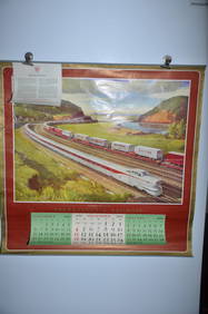
1954 Pennsylvania Railroad Calendar-Pittsburgh Promotes ProgressJM Hobby Supply and Railroad Artifact Auctions4.4(126)See Sold PriceFeb 24, 2024
1956 Pennsylvania Railroad Calendar-Dynamic ProgressJM Hobby Supply and Railroad Artifact Auctions4.4(126)See Sold PriceFeb 24, 2024
WILLIAM HENRY DETHLEF KOERNER (NJ/NY/MT, 1878-1938)Thomaston Place Auction Galleries4.4(389)See Sold PriceFeb 25, 2024
Parker Vacuum Filler Demonstrator Fountain PenNorth American Pen Auctions LTD4.4(12)See Sold PriceFeb 24, 2024
Natural History - Boxed Selenite Mineral Specimen Group [10].TimeLine Auctions Ltd.4.6(182)See Sold PriceMar 08, 2024
Natural History - Large Petrified Fossil Tree Trunk SectionTimeLine Auctions Ltd.4.6(182)See Sold PriceMar 08, 2024
Natural History - Boxed Unpolished Fossil Tree Branch Section Group [8]TimeLine Auctions Ltd.4.6(182)See Sold PriceMar 08, 2024
Natural History - Agate Crystal Geode Cut Section Collection [3].TimeLine Auctions Ltd.4.6(182)See Sold PriceMar 09, 2024
Natural History - Very Large Fossil Orthoceras SculptureTimeLine Auctions Ltd.4.6(182)See Sold PriceMar 09, 2024
Natural History - Large Cut Agate Section Group [2].TimeLine Auctions Ltd.4.6(182)See Sold PriceMar 09, 2024
Natural History - Unpolished Fossil Tree Branch Section Group [10]TimeLine Auctions Ltd.4.6(182)See Sold PriceMar 09, 2024
Natural History - Aquamarine Topaz Mineral Specimen Group [20].TimeLine Auctions Ltd.4.6(182)See Sold PriceMar 09, 2024
1852 CHART SHOWING POSITIONS of DAVIS'S SOUTH SHOAL & OTHER DANGERS antiqueJasper524.5(9.8k)See Sold PriceFeb 27, 2024
AMALIA AVIA PEÑA (Santa Cruz de la Zarza, Toledo, 1930 - Madrid, 2011). "Los Gabrieles - Seville".Setdart Auction House4(23)See Sold PriceMar 05, 2024
LIFAR SERGE: (1905-1986)International Autograph Auctions Europe S.L.4.5(52)See Sold PriceMar 13, 2024
Disney Richard Harrison Green Sketch 101 DalmatiansRapid Estate Liquidators and Auction Gallery4.5(1.1k)See Sold PriceFeb 28, 2024
Disney Animator Sketches- Chi FuRapid Estate Liquidators and Auction Gallery4.5(1.1k)See Sold PriceFeb 28, 2024


![... Sketch I Showing the Progress of the Survey in Section No.Ix [Gulf Coast of Texas] (1 of 3)](https://p1.liveauctioneers.com/5584/289753/153468791_1_x.jpg?height=282&quality=70&version=1684878062)


![Natural History - Boxed Selenite Mineral Specimen Group [10]. (1 of 1)](https://p1.liveauctioneers.com/1191/317892/170615796_1_x.jpg?height=282&quality=70&version=1706617191)

![Natural History - Boxed Unpolished Fossil Tree Branch Section Group [8] (1 of 1)](https://p1.liveauctioneers.com/1191/317892/170615929_1_x.jpg?height=282&quality=70&version=1706617191)
![Natural History - Agate Crystal Geode Cut Section Collection [3]. (1 of 1)](https://p1.liveauctioneers.com/1191/317894/170617057_1_x.jpg?height=282&quality=70&version=1706620797)

![Natural History - Large Cut Agate Section Group [2]. (1 of 1)](https://p1.liveauctioneers.com/1191/317894/170617152_1_x.jpg?height=282&quality=70&version=1706620797)
![Natural History - Unpolished Fossil Tree Branch Section Group [10] (1 of 1)](https://p1.liveauctioneers.com/1191/317894/170617154_1_x.jpg?height=282&quality=70&version=1706620797)
![Natural History - Aquamarine Topaz Mineral Specimen Group [20]. (1 of 1)](https://p1.liveauctioneers.com/1191/317894/170617157_1_x.jpg?height=282&quality=70&version=1706620797)