ATLAS of ANTIENT GEOGRAPHY by SAMUEL BUTLER 1843John McInnis Auctioneers,LLC4.5(505)See Sold PriceFeb 24, 2024
18TH C. ANTIQUE MAP: FRENCH & INDIAN WAR, FRAMEDThomaston Place Auction Galleries4.4(393)See Sold PriceFeb 24, 2024
Rand McNally Railroad Map Cabinet w/ 21 Railroad MapsRail & Road Auctions4.6(165)See Sold PriceMar 08, 2024
Keith Haring - Ink on New York Map, Best Buddies, Inscribed, Signed, and DatedSapphire Auction Gallery4(67)See Sold PriceMar 02, 2024
LATE 17TH C. FRENCH MAP OF THE NEW WORLD BY ALEXIS-HUBERT JAILLOT (1632-1712)Thomaston Place Auction Galleries4.4(393)See Sold PriceFeb 24, 2024
Central Railroad of New Jersey Map of Sandy Hook Route-ca. 1903JM Hobby Supply and Railroad Artifact Auctions4.4(127)See Sold PriceFeb 24, 2024
Lot of Six Mixed Atlas Box Cars-HO Scale-New in BoxJM Hobby Supply and Railroad Artifact Auctions4.4(127)See Sold PriceFeb 25, 2024
Rand McNally/Santa Fe Railroad Map of Iowa-1912JM Hobby Supply and Railroad Artifact Auctions4.4(127)See Sold PriceFeb 24, 2024
NICOLAES VISSCHER (NETHERLANDS, 1618-1709) MAP OF THE NEW WORLDThomaston Place Auction Galleries4.4(393)See Sold PriceFeb 24, 2024
17TH C. WORLD MAP BY NICOLAES VISSCHER (NETHERLANDS, 1618-1709)Thomaston Place Auction Galleries4.4(393)See Sold PriceFeb 24, 2024
Lot of Six Mixed Atlas Cabooses-HO Scale-New in BoxJM Hobby Supply and Railroad Artifact Auctions4.4(127)See Sold PriceFeb 25, 2024
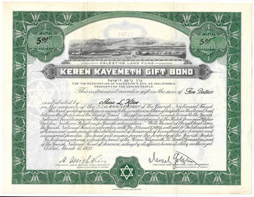
SoldSeutter Map of Palestine, 1753Title: 1753 Seutter Map of Palestine Cartographer: M Seutter Published: 1753 Nurnberg Measurements: 19.2 x 22.4 in. Palaestinae Accurata Descriptio Geographica, Ita Adornata, ut Diversarum Aetatum RegSee Sold Price
SoldSeutter: Map of Africa, 17531753 Seutter Map of Africa -- Africa Iuxta Navigationes et Observationes Recentissimas Aucta Correcta et in Sua Regna et Status Divisa, in Lucem Edita. 1753 Nurnberg. 19.2 x 22.4 in. This striking mapSee Sold Price
SoldSeutter: Map of Asia, 1753Map: 1753 Seutter Map of Asia -- Asia cum Omnibus Imperiis Provinciis, Statibus et Insulis Iuxta Observationes Recentissimas et Accuratissima… Cartographer: J. Homann Year/Place: 1753 Nurnberg DimenSee Sold Price
1753 Seutter Map of AfricaTitle: 1753 Seutter Map of Africa -- Africa Iuxta Navigationes et Observationes Recentissimas Aucta Correcta et in Sua Regna et Status Divisa, in Lucem Edita Cartographer: M Seutter Origin/Date: 1753See Sold Price
Seutter: Map of North Italy, Ducatus Mediolanensis 17301730 Seutter Map of Northern Italy -- Ducatus Mediolanensis. 1753 Nurnberg. 19.2 x 22.4 in. A superb map of northern Italy from the Mediterrian to the Lake District, with great deal of topographical,See Sold Price
SoldSeutter Map of Northern Italy, 1730Map: 1730 Seutter Map of Northern Italy -- Ducatus Mediolanensis … Cartographer: M. Seutter Year / Place: 1753 Nurnberg Map Dimension: 19.2 x 22.4 in. A superb map of northern Italy from the MediterSee Sold Price
Sold86: HAND COLORED ENGRAVED MAP, PALESTINE/HOLY LANDSHAND COLORED ENGRAVED MAP, PALESTINE AND THE HOLY LANDS, SIGNED MATTHAUS SEUTTER (GERMAN 1678-1757) 18TH CENTURY. PLATE 20 X 23 1/4 (LAID DOWN; EDGE SHEET CHIPS) **NO IN-HOUSES SHIPPING**See Sold Price
SoldGEORG M. SEUTTER, MAP OF NORTHEAST AMERICA, LATERGeorg Matthaus Seutter (German, 1678-1757), second state, later impression. "Recens Edita totius Novi Belgii, in America Septentrionali siti, delineatio cura et sumtibus Matthaei Seutteri, Sac. Caes.See Sold Price
Sold1730 Original Seutter Map New England, NYOriginal 1730 hand-colored map in Latin and Dutch "Recens edita totius Novi Belgii in America Septentrionali," by Matthew Sutter (German), illustrating the north-eastern region of what is now the UnitSee Sold Price
Seutter: Map of Barcelona, 1740Barcellona die Haupt Statt des Spanischen Fürstenthums Catalonien Seutter's detailed plan of the Catalan capital of Barcelona in contemporary color, with an uncolored view of the city beneath it. BotSee Sold Price
Sauerbrey: Maris Pacifici Map, 1753Map: Tabula geographica partis septentrionalis Maris Pacifici cum adiacentibus regionibus. Nicolaus Sauerbrey's superbly detailed Northwest Passage map from Euler's Atlas is a reduced version of the lSee Sold Price
SoldSeutter Map of N. America: ACCURATA DELINEATIO..[North America/Seutter]. ACCURATA DELINEATIO CELEBERRIMAE REGIONIS LUDOVICIANAE VEL GALLICE LOUISANE... Chalcog. Augustan. [Augsburg: c. 1740.] Double-page map of North America by Matthew Seutter, shoSee Sold Price
SoldMatthias Seutter Map of America - Novus Orbis SiveAntique Map of the Americas Hand Colored Print. Novus Orbis, Sive, America. Depicts Calif as an island.-- Dimensions: Image Size: H: 14 inches: W: 16.25 inches ---See Sold Price
1740 Seutter Map of Japan -- Imperium Japonicum perTitle/Content of Map: 1740 Seutter Map of Japan -- Imperium Japonicum per Sexaginta et Sex Regiones Digestum atque ex Ipsorum Japonensium Mappis Descriptum … Date Printed: 1740 c., Augsburg CartograSee Sold Price
SoldAfter Matthaeus Seutter Map of North AmericaAfter Matthaeus Seutter (1678-1757) colored engraving map of North America. Dimensions: Sight; height: 18 1/2 in x width: 21 1/2 in. Framed; height: 25 1/4 in x width: 28 in. SKU: 03585See Sold Price
SoldSeutter Map of Eastern North America Referencing theSeutter, Matthias. Accurata delineatio celeberrimae regionis Ludovicianae vel Gallice Louisiane ol. Canadae et Floridae Adpellatione in Septemtrionali America... (Augsburg, 1730), copperplate engravinSee Sold Price
SoldSauerbrey/Euler: Northwest Passage Map, 1753Map: Tabula geographica partis septentrionalis Maris Pacifici cum adiacentibus regionibus Cartographer: Sauerbrey/Euler Place & Date: Berlin / 1753 Size: 15 1/8" x 12 7/8" Condition: original wash colSee Sold Price
SoldANTIQUE MAP "PALESTINE"By Johnson and Ward. With hand coloring. Dimensions: (Frame) H 21.5" x W 17", (Sight) H 16" x W 12.75" Condition: Toning. Handling wear including rubs to frame.See Sold Price
Seutter: Map of Lower Austria, 1770Map: Archiducatus Austriae Inferioris Publication Date: 1770 ca. Maker: TOB. CONRAD LOTTER, SEUTTER, ALBRECHT KARL (1722-1762) Publisher: TOB. CONRAD LOTTER Size: Quarto – 7.60 H x 10.00 W Inches DeSee Sold Price
SoldAfter Matthaeus Seutter: Map of North America.After Matthaeus Seutter: Map of North America. Colored engraving Sight: 18" x 21"See Sold Price
SoldSeutter map of the Ukraine c.1770Heading: (Ukraine) Author: Seutter, Matthew Title: Amplissima Ucraniae Regio Palatinatus Kioviensem et Braclaviensem… Place Published: Augsburg Publisher: Date Published: c.1770 DescripSee Sold Price
SoldToms & Cellarius 1789 Map. Palestine, Israel"Palaestina sev Terra Sancta" Copper Engraved Map Published 1789, London for "Geographia Antiqua" Engraved W. H. Toms after an earlier map by Christoph Cellarius. Centre fold as published. Paper Size:See Sold Price
Seutter Map of Northern Italy, 17301730 Seutter Map of Northern Italy -- Ducatus Mediolanensis …A superb map of northern Italy from the Mediterrian to the Lake District, with great deal of topographical, political division, road andSee Sold Price
Sold1887 Hand Colored Map Palestine & Environs of Jerusalem1887 Hand Colored Engraving "Map of Palestine" with an inset of the "Environs of Jerusalem"Signed in plate: Bradley 1887Size: Approximately 8 1/4" x 11 1/4"Condition: A fSee Sold Price
Jerusalem Map for British Soldiers in Palestine - WW2Levy Auction House4.3(11)See Sold PriceFeb 27, 2024
Proposed Sportsground Map - Haifa, Palestine - 1926Levy Auction House4.3(11)See Sold PriceFeb 27, 2024
Caravan Routes in Palestine Linen Map - Germany, 1881Levy Auction House4.3(11)See Sold PriceFeb 27, 2024
The Holy Land Tours - Hamburg American Line - 1911Levy Auction House4.3(11)See Sold PriceFeb 27, 2024
18 Booklets Collection - War Graves of Palestine - WWILevy Auction House4.3(11)See Sold PriceFeb 27, 2024
Illustrated Sabbath Cloth - Holy Sites of Eretz IsraelLevy Auction House4.3(11)See Sold PriceFeb 27, 2024
18th Century Hess Germany Hand colored Engraved MapGlobal Auctions Company4.3(36)See Sold PriceMar 03, 2024