SoldSeutter (M) 3 maps of northern GermanySeutter (Matthaeus) Marchia sive Electoratus Brandenburgicus nec non Ducatus Pomeraniae...; Electoratus sive Marchia Brandenburgensis; Saxoniae Inferioris Circulus, the Baltic coast of northerSee Sold Price
SoldSeutter (M) 3 maps of east GermanySeutter (Matthaeus) Anhaltinus Principatus Stirpis Ascaniensis; Dynastiae Comitato Schoenburgici; Praefecturarum Colditium Leissnigium, Rochlitium,four maps of eastern Germany, 3 with decoratiSee Sold Price
Sold18thC Hand-Colored Map, Germany, M. Seutter18th century hand-colored map, Germania Augustiniana by Matthaus Seutter, S.C.M. (German, 1678-1757), framed 28" x 31". Provenance: Del Mar, California collection.See Sold Price
SoldSeutter (Mattheus) 3 maps of n-w GermanySeutter (Mattheus) Ducatus Brunsuicensis; Electoratus Hanoverani; Ducatus Luneburgicus cum Commitatu Dannebergensi 3 engraved maps of north-west Germany, with hand-colouring, each with centralSee Sold Price
(3) ANTIQUE MAPS, GERMANY, 17TH & 18TH C.(lot of 3) Antique maps, including: (1) "Dithmarshen" (Northern Germany), with inset maps of "Brunsbuttel, 1644" and "Meldorpia, 1500," Johannes Mejer (German, c.1606-1674), hand colored, including seSee Sold Price
1602 Ortelius Map of Northern Germany-- ThietmarsiaTitle/Content of Map: 1602 Ortelius Map of Northern Germany-- Thietmarsia Holsatlae Region. Pars. Cartographer: A Ortelius Year/Place: 1602, Antwerp Size: 3.2 X 4.4 in. This is a charming smaller mapSee Sold Price
1602 Ortelius Map of Northern Germany-- Thietmarsia Holsatlae Region. Pars.Title: 1602 Ortelius Map of Northern Germany-- Thietmarsia Holsatlae Region. Pars. Cartographer: A Ortelius Year / Place: 1602, Antwerp Map Dimension (in.): 3.2 X 4.4 in. This is a charming smaller maSee Sold Price
1602 Ortelius Map of Northern Germany-- ThietmarsiaTitle: 1602 Ortelius Map of Northern Germany-- Thietmarsia Holsatlae Region. Pars. Cartographer: A Ortelius Year / Place: 1602, Antwerp Map Dimension (in.): 3.2 X 4.4 in. This is a charming smaller maSee Sold Price
Sold[SEUTTER] 4 maps sold together. ca. 1700SEUTTER, M. 4 maps sold together. ca. 1700. Including: Africa [Continental], Matthaei Seutteri ** Africa[Northern], Matthaei Seutteri ** Palestina, Matthaei Seutteri ** Opulentissimi Regni Persia, MatSee Sold Price
SoldMap: Ruscelli Girolamo. Tabula Europae IIII(Italian, 1518-1566). Hand-colored map showing Northern Germany and Denmark, 14 1/2 x 10 3/4 in., in painted and giltwood frameSee Sold Price
SoldEMERGENCY/ESCAPE SILK MAP OF CENTRAL EUROPEWehrmacht issue 1: 1,000,000 scale map, 33 3/4" x 31", depicting northern Germany, "Protectorate" (Bohemia & Moravia)", northern Slovakia, Poland and Northern Hungary on one side, and Croatia, MonteneSee Sold Price
Map: Ruscelli Girolamo. Tabula Europae IIII(Italian, 1518-1566) hand-colored map showing Northern Germany and Denmark, 14 1/2 x 10 3/4 in., in painted and gilt wood frameSee Sold Price
Seutter, M. Novi Belgii, in America SeptentrionaliSeutter, Matthaus Recens edita totius Novi Belgii, in America Septentrionali siti, delineatio C. 1735 Copperplate engraving; old coloured Printed area: 57 x 49 cm; 22.4 x 19.3 in This map is based upoSee Sold Price
SoldSeutter (Matthaeus) Episcopatus HildesiensisSeutter (Matthaeus) Episcopatus Hildesiensis,with Saxoniae Superioris Circulus and Landgraviatus Thuringiae, 3 engraved maps of Germany, each c.490 x 570mm., with central vertical fold, faintSee Sold Price
Seutter, M. Electoratus sive Marchia BrandenburgensisSeutter, Matthaus Electoratus sive Marchia Brandenburgensis C. 1725 Copperplate engraving; area coloured Printed area: 55.6 x 49.2 cm; 21.8 x 19.3 in The map shows the the elective area of the Mark BrSee Sold Price
Sold3 GERMAN WWII-ERA MAPSThree WWII-era German maps. One map is an official map of the Berlin area Usual map folds. 24 x 29.75 inches. Next is a 1932 map of Eutin-Lubeck, a city in Northern Germany near the Baltic Sea. UsualSee Sold Price
SoldMontana Tourist MemorabiliaThis lot is Montana Tourist Memorabilia. There are 40 Public Lands in Montana maps of different areas, 3 Charles M. Russell National Wilderness Refuge maps, 1 Northern Pacific Yellowstone Park Line brSee Sold Price
SoldSeutter (M) Praefectura LipsiensisSeutter (Matthaeus) Praefectura Lipsiensis, with Ducatus Magdeburgensis et Halensis and Ditionis Martinsburgensis, three maps of north-west Germany, the regions of Leipzig, Magdeburg and eachSee Sold Price
Seutter, M. Carte des Iles de Maiorque, MinorqueSeutter, Matthaus Carte des Iles de Maiorque, Minorque et d'Yvice 1741 Copperplate engraving; coloured Printed area: 56 x 49 cm; 22 x 19.3 in A rare map of the Balearic Islands with the Port of MahonSee Sold Price
SoldGroup of 3 18th Century Maps, paper backed, 20x23,Group of 3 18th Century Maps, paper backed, 20x23, Scandinavia Sueciae Dania & Nor Map of Scandinavia, the Baltic States, northern most part of current Germany, and parts of Poland and Russia, by JohaSee Sold Price
SoldTravel Hand-Books 19th Century (3)Group of three nineteenth century travel handbooks. Includes: 1) Baedeker's Northern Germany. 1873. 294 pp. plus maps. Measures 6.375 in. x 4.25 in. x .75 in. 2) Murray's Hand-Book Northern Italy. 189See Sold Price
1834 Malte-Brun Map of Germany -- Germany Divided uintoReserve Reduced! Title/Content of Map: 1834 Malte-Brun Map of Germany -- Germany Divided uinto Circles Date: 1834, Boston Cartographer: M. Malte-Brun / S. Walker Size: 9.3 x 7.5 in. An attractive andSee Sold Price
1834 Malte-Brun Map of Germany -- Germany Divided intoTitle/Content of Map: 1834 Malte-Brun Map of Germany -- Germany Divided into Circles Date: 1834, Boston Cartographer: M. Malte-Brun / S. Walker Size: 9.3 x 7.5 in. An attractive and highly detailed maSee Sold Price
1834 Malte-Brun Map of Germany -- Germany Divided intoTitle/Content of Map: 1834 Malte-Brun Map of Germany -- Germany Divided into Circles Date: 1834, Boston Cartographer: M. Malte-Brun / S. Walker Size: 9.3 x 7.5 in. An attractive and highly detailed maSee Sold Price
Archaeological Books - Kemble - Horae Ferales; or Studies in the Archaeology of the Northern NationsTimeLine Auctions Ltd.4.6(182)See Sold PriceMar 06, 2024
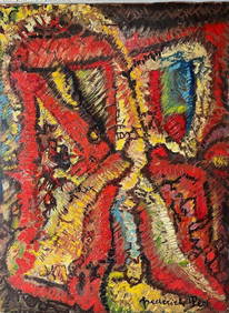
Frederick M Perl Germany California 1890 - 1963 Oil Painting Abstract 1956Global Auctions Company4.3(36)See Sold PriceMar 03, 2024
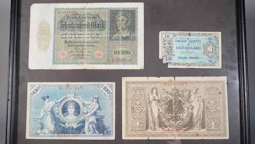
Framed 20th Century Germany Mark Currency Collection Neo FineArts Inc4.4(13)See Sold PriceFeb 25, 2024
17th Century Hand Colored Engraved Map of GermanyGlobal Auctions Company4.3(36)See Sold PriceMar 03, 2024
18th Century Hess Germany Hand colored Engraved MapGlobal Auctions Company4.3(36)See Sold PriceMar 03, 2024
A. M. CASSANDRE (Adolphe Mouron, 1901-1968)Poster Auctions International4.3(1)See Sold PriceMar 03, 2024
1816 MAP NORTHERN PART OF RUSSIA or MUSCOVY in EUROPE copper engraving ANTIQUEJasper524.5(9.8k)See Sold PriceFeb 27, 2024
Western Germany Pottery PlanterM.J. Stasak Jr. Auction and Appraisal Service4.8(2.1k)See Sold PriceMar 10, 2024
Rudolstadt Germany Double Handled VaseM.J. Stasak Jr. Auction and Appraisal Service4.8(2.1k)See Sold PriceMar 10, 2024
Vintage West Germany 1200 Years of Frankfurt A. M. Stoneware Tumbler Cup 4.25"Andrew's Coin & Jewelry4.5(209)See Sold PriceMar 07, 2024


![[SEUTTER] 4 maps sold together. ca. 1700 (1 of 2)](https://p1.liveauctioneers.com/1124/187577/94368890_1_x.jpg?height=282&quality=70&version=1607095126)