ATLAS of ANTIENT GEOGRAPHY by SAMUEL BUTLER 1843John McInnis Auctioneers,LLC4.6(502)See Sold PriceFeb 24, 2024
18TH C. ANTIQUE MAP: FRENCH & INDIAN WAR, FRAMEDThomaston Place Auction Galleries4.4(386)See Sold PriceFeb 24, 2024
Rand McNally Railroad Map Cabinet w/ 21 Railroad MapsRail & Road Auctions4.6(165)See Sold PriceMar 08, 2024
Keith Haring - Ink on New York Map, Best Buddies, Inscribed, Signed, and DatedSapphire Auction Gallery4(67)See Sold PriceMar 02, 2024
LATE 17TH C. FRENCH MAP OF THE NEW WORLD BY ALEXIS-HUBERT JAILLOT (1632-1712)Thomaston Place Auction Galleries4.4(386)See Sold PriceFeb 24, 2024
Central Railroad of New Jersey Map of Sandy Hook Route-ca. 1903JM Hobby Supply and Railroad Artifact Auctions4.4(126)See Sold PriceFeb 24, 2024
Lot of Six Mixed Atlas Box Cars-HO Scale-New in BoxJM Hobby Supply and Railroad Artifact Auctions4.4(126)See Sold PriceFeb 25, 2024
Rand McNally/Santa Fe Railroad Map of Iowa-1912JM Hobby Supply and Railroad Artifact Auctions4.4(126)See Sold PriceFeb 24, 2024
NICOLAES VISSCHER (NETHERLANDS, 1618-1709) MAP OF THE NEW WORLDThomaston Place Auction Galleries4.4(386)See Sold PriceFeb 24, 2024
17TH C. WORLD MAP BY NICOLAES VISSCHER (NETHERLANDS, 1618-1709)Thomaston Place Auction Galleries4.4(386)See Sold PriceFeb 24, 2024
Lot of Six Mixed Atlas Cabooses-HO Scale-New in BoxJM Hobby Supply and Railroad Artifact Auctions4.4(126)See Sold PriceFeb 25, 2024
SoldSeutter Africa MapAfrica juxta navigationes et observat recentissimas.. Matthias Seutter (1678-1757). Augsburg, J.M.Will, 1778. Engraved Map with Hand color in full. 8 1/4 x 10 1/2 inches visible, 15 1/2 x 17 inches frSee Sold Price
Soldca 1730 map Africa by Seutterca 1730 "Africa juxta navigationes et observat recentillimas" by Mattheus Seutter (1678- 1756), Augsburg, hand-colored, 8 1/4" x 10 1/2"See Sold Price
SoldSeutter: Antique Map of Africa, 1740Title/Content of Map: Africa by Seutter c1740 Cartographer: Matthaus Seutter Material/Medium: Paper Size: 24" x 19 1/2" Original hand colored Copperplate engraved. Published in Augsburg in 'Atlas NovuSee Sold Price
SoldSeutter: Map of Africa, 17531753 Seutter Map of Africa -- Africa Iuxta Navigationes et Observationes Recentissimas Aucta Correcta et in Sua Regna et Status Divisa, in Lucem Edita. 1753 Nurnberg. 19.2 x 22.4 in. This striking mapSee Sold Price
1753 Seutter Map of AfricaTitle: 1753 Seutter Map of Africa -- Africa Iuxta Navigationes et Observationes Recentissimas Aucta Correcta et in Sua Regna et Status Divisa, in Lucem Edita Cartographer: M Seutter Origin/Date: 1753See Sold Price
Three maps of Africa - Maps, MapsMatthäus Seutter (1678-1757), AFRICA, copper engraving, handcoloured, published by Tobias Lotter, Augsburg, ca. 1740, 22 cm x 28 cm (8.6 x 11 in); Johann C.G. Schreibern (1676-1750), AFRICA, copper eSee Sold Price
Three maps of Africa - MapsMatthäus Seutter (1678-1757), AFRICA, copper engraving, handcoloured, published by Tobias Lotter, Augsburg, ca. 1740, 22 cm x 28 cm (8.6 x 11 in); Johann C.G. Schreibern (1676-1750), AFRICA, copper eSee Sold Price
SoldAfrica.- Seutter (Matthäus) Africa IuxtaAfrica.- Seutter (Matthäus) Africa Iuxta Navigationes et Observationes Recentissimas Aucta Correcta et in sua Regna et Status Divisa, in Lucem Edita, map of Africa based largely on Homann's 1715See Sold Price
SoldSeutter (M.) Africa Iuxta NavigationesSeutter (Matthaeus) Africa Iuxta Navigationes Et Observationes Recentissimas Aucta Correcta Et In Sua Regna Et Staus Divisa, engraved map of the continent, with decorative title cartouche withSee Sold Price
SoldSeutter (Matthaeus) - Africa iuxta Navigationes etthe continent, with decorative vignette title of animals, mythological creatures and native figures, engraved map with original hand-colouring, 500 x 575mm., central vertical fold, Augsburg, Johan MicSee Sold Price
SoldSeutter (Matthaeus) - Africa Iuxta Navigationes Etthe continent and islands, large title vignette with pyramids, a dragon, African peoples and animals, lower left, engraved map with original hand-colouring, 495 x 570mm., faint central vertical fold,See Sold Price
SoldAfrica.- Seutter (Matthäus) Africa IuxtaAfrica.- Seutter (Matthäus) Africa Iuxta Navigationes et Observationes Recentissimas Aucta Correcta et in sua Regna et Status Divisa, map of Africa based largely on Homann's 1715 map, with MadagaSee Sold Price
Africa.- Seutter (Matthäus) Africa IuxtaAfrica.- Seutter (Matthäus) Africa Iuxta Navigationes et Observationes Recentissimas Aucta Correcta et in sua Regna et Status Divisa, in Lucem Edita, map of Africa based largely on Homann's 1715See Sold Price
SoldGorgeous example of Seutter's map of AfricaAfrica Iuxta Navigationes et Observationes Recentissimas Aucta Correcta et in Sua Regna et Status Divisa, in Lucem Edita. Matthaus Seutter (1678-1757). Engraved Map with original hand color in part. ASee Sold Price
SoldSeutter (Georg Matthäus) Africa luxta navigationesSeutter (Georg Matthäus) Africa luxta navigationes et observationes recentissimas aucta correctaet in sua regna et status divisa, engraved map of the continent, with decorative title cartoucheSee Sold Price
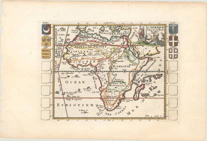
Sold[SEUTTER] 4 maps sold together. ca. 1700SEUTTER, M. 4 maps sold together. ca. 1700. Including: Africa [Continental], Matthaei Seutteri ** Africa[Northern], Matthaei Seutteri ** Palestina, Matthaei Seutteri ** Opulentissimi Regni Persia, MatSee Sold Price
SoldAfricaTitle: Africa Date/Period: 1730-1740 Materials: Hand colored copperplate engraved Dimensions: 25 1/2 x 21 1/2”. AFRICA c1730-1740 by G. M. Seutter, Augsburg, Germany.Hand One of the most important GSee Sold Price
AfricaTitle: Africa Date/Period: 1730-1740 Materials: Hand colored copperplate engraved Dimensions: 25 1/2 x 21 1/2”. AFRICA c1730-1740 by G. M. Seutter, Augsburg, Germany.Hand One of the most important GSee Sold Price
AfricaTitle: Africa Date/Period: 1730-1740 Materials: Hand colored copperplate engraved Dimensions: 25 1/2 x 21 1/2”. By M. Seutter. Published. Augsburg, Germany Reserve: $800.00 Shipping: Domestic: FreeSee Sold Price
SoldGEORG M. SEUTTER, MAP OF NORTHEAST AMERICA, LATERGeorg Matthaus Seutter (German, 1678-1757), second state, later impression. "Recens Edita totius Novi Belgii, in America Septentrionali siti, delineatio cura et sumtibus Matthaei Seutteri, Sac. Caes.See Sold Price
Sold1730 Original Seutter Map New England, NYOriginal 1730 hand-colored map in Latin and Dutch "Recens edita totius Novi Belgii in America Septentrionali," by Matthew Sutter (German), illustrating the north-eastern region of what is now the UnitSee Sold Price
Seutter: Map of Barcelona, 1740Barcellona die Haupt Statt des Spanischen Fürstenthums Catalonien Seutter's detailed plan of the Catalan capital of Barcelona in contemporary color, with an uncolored view of the city beneath it. BotSee Sold Price
SoldSeutter Map of N. America: ACCURATA DELINEATIO..[North America/Seutter]. ACCURATA DELINEATIO CELEBERRIMAE REGIONIS LUDOVICIANAE VEL GALLICE LOUISANE... Chalcog. Augustan. [Augsburg: c. 1740.] Double-page map of North America by Matthew Seutter, shoSee Sold Price
SoldSeutter Map of Palestine, 1753Title: 1753 Seutter Map of Palestine Cartographer: M Seutter Published: 1753 Nurnberg Measurements: 19.2 x 22.4 in. Palaestinae Accurata Descriptio Geographica, Ita Adornata, ut Diversarum Aetatum RegSee Sold Price
CHARLES ROLLIN c1828 Ceasar Hand Colored Africa Military MapLuis Porretta Fine Arts4.3(10)See Sold PriceMar 02, 2024
AFRICA. Map pre-dating much exploration. Mountains of Kong. SDUK 1851 oldJasper524.5(9.8k)See Sold PriceFeb 28, 2024
AFRICA. Antiqua; Rome Carthage, start Punic War 1908 old antique map chartJasper524.5(9.8k)See Sold PriceFeb 28, 2024
Pre-colonial Africa. Mountains of Kong/Moon. Caravan routes. THOMSON 1817 mapJasper524.5(9.8k)See Sold PriceFeb 28, 2024
SOUTHERN AFRICA. Congo British/Portuguese/German East Africa Rhodesia 1912 mapJasper524.5(9.8k)See Sold PriceFeb 28, 2024
AFRICA. Africa. General Map; Inset map of Population map 1907 old antiqueJasper524.5(9.8k)See Sold PriceFeb 28, 2024
AFRICA. Africa. Britannica 9th edition 1898 old antique vintage map plan chartJasper524.5(9.8k)See Sold PriceFeb 28, 2024
Pre-SECOND WORLD WAR AFRICA. European colonies & German mandates 1942 old mapJasper524.5(9.8k)See Sold PriceFeb 28, 2024
AFRICA. Political Map of showing International Boundaries 1936 old vintageJasper524.5(9.8k)See Sold PriceFeb 28, 2024
NORTH EAST AFRICA. Libya Egypt Sudan Ethiopia Ubangi-Shari Chad 1952 old mapJasper524.5(9.8k)See Sold PriceFeb 28, 2024
Central Africa. Map showing great forest traversed by Mr Stanley, 1890Jasper524.5(9.8k)See Sold PriceFeb 28, 2024
ANCIENT NORTH AFRICA Septentrionalis. Mauretania Tripolitana ARROWSMITH 1828 mapJasper524.5(9.8k)See Sold PriceFeb 28, 2024


![[SEUTTER] 4 maps sold together. ca. 1700 (1 of 2)](https://p1.liveauctioneers.com/1124/187577/94368890_1_x.jpg?height=282&quality=70&version=1607095126)