SoldSet of 3 U.S. Geological Survey Copper Map PlatesRare Antique Set of Three United States Geological Survey (USGS) Copper Map Plates, each of the three engraved plates illustrating a topographical map of Continental, Ohio, 4100 N latitude and 8415 WSee Sold Price
SoldThree Rare US Geological Survey Copper Map PlatesRare Vintage Set of Three United States Geological Survey (USGS) Copper Map Plates, each of the three engraved plates illustrating a topographical map of Holston Valley, the tri-city region of KingspoSee Sold Price
SoldThree Rare US Geological Survey Copper Map PlatesRare Antique Set of Three United States Geological Survey (USGS) Copper Map Plates, each of the three engraved plates illustrating a topographical map of Continental, Ohio, 4100 N latitude and 8415 WSee Sold Price
U.S GOVERNMENT SURVEY COPPER MAP PLATES, SET OF 3Park Ridge, NJ-NY US Government Copper Map Engravings for Park Ridge, NJ-NY, scale 1:31,680 surveyed 1934-1944. The Original Master Set engraved on 3 plates measures approximately 21 in. H x 17 in. W.See Sold Price
SoldU.S GOVERNMENT SURVEY COPPER MAP PLATES, SET OF 3East Greenwich, RI 1942 US Government Copper Map Engravings for East Greenwich, RI, scale 1:31,680 surveyed in 1942. The Original Master Set engraved on 3 plates measures approximately 21 in. H x 17 iSee Sold Price
SoldU.S GOVERNMENT SURVEY COPPER MAP PLATES, SET OF 3Park Ridge, NJ-NY US Government Copper Map Engravings for Park Ridge, NJ-NY, scale 1:31,680 surveyed 1934-1944. The Original Master Set engraved on 3 plates measures approximately 21 in. H x 17 in. W.See Sold Price
U.S GOVERNMENT SURVEY COPPER MAP PLATES, SET OF 3North Truro, Cape Cod, MA 1942-1948. US Government Copper Map Engravings for North Truro, MA, scale 1:31, 680 surveyed 1942-1948. The Original Master set engraved on 3 plates measures approximately 21See Sold Price
Copper Engravings, United States Geological Survey(lot of 3) United States Geological Survey (USGS) Copper Map Plates, each of the three engraved plates illustrating a topographical map of Salinas and Los Altos, California, each plate dated 1802, oveSee Sold Price
U.S GOVERNMENT SURVEY COPPER MAP PLATES, SET OF 4Livingston, MT 1886-1887 US Government Copper Map Engravings for Livingston, MT, scale 1:125,000 surveyed 1886-1887. The Original Master Set engraved on 4 plates measure approximately 21 in. H x 17 inSee Sold Price
U.S GOVERNMENT SURVEY COPPER MAP PLATES, SET OF 4Livingston, MT 1886-1887 US Government Copper Map Engravings for Livingston, MT, scale 1:125,000 surveyed 1886-1887. The Original Master Set engraved on 4 plates measure approximately 21 in. H x 17 inSee Sold Price
SoldRare Pair of United States Geological Survey (USGS)Rare Pair of United States Geological Survey (USGS) Copper Map Plates, 1880-1950, each of the two engraved plates illustrating a topographical map of the Rigolets and Lake Borgne, with parts of OrleanSee Sold Price
SoldLot of 3 large maps, US Geological Survey by PikeLot of 3 large maps, US Geological Survey by Pikes Peak Lithographing Co, CO. 1) Florida 1995, 2) Georgia 1994, 3) Michigan 1995. Approximate size 44" x 47".See Sold Price
SoldUS Geological Survey Vol. I 1890 Lake BonnevilleTitle: Lake Bonneville Author: Gilbert, Grove Karl Description: xx, 438 pp. Many map plates within, as well as a large loose folding map of Lake Bonneville in color, placed in rear pocket. (4to), origSee Sold Price
SoldANTIQUE LINED MA NY VT TACONIC QUADRANGLE MAPdepartment of interior US geological survey map. has been lined and cut . current measurement 17 3/4" by 13". map shows some highlighted travel routeSee Sold Price
Copper Printing Plate of Bluff Harbor, New Zealand20th century: etched copper map plate, 24 x 36 in., with an example of the map as printed, indicating that it is a U.S. Survey Map dated 1951See Sold Price
Sold1955 wall map of Alaska1955 US geological Survey wall map of Alaska (map B), on original rollers, 4'3" x 5' 7"See Sold Price
Sold83 U. S. Geological Survey maps, mostly 1903-08.[Topography] 83 U.S. Geological Survey topographical maps, each printed color and approx. 18 x 13 ¼ in. Includes 33 of Massachusetts, 22 of Connecticut, 5 of Rhode Island, 3 of New Jersey, 15 of VermSee Sold Price
Sold(3) MAPS: UNITED STATES, MARTHA'S VINEYARD, EUROPE(lot of 3) Framed maps, including: (1) Martha's Vineyard, U.S. Geological Survey, sight: 10.25"h, 14.25"w, overall: 12"h, 16"w, (1) Hungarian map of Europe, sight: 8.25"h, 10"w, overall: 13.25"h, 15"wSee Sold Price
SoldEMORY, WILLIAM H. Report on the United StatesEMORY, WILLIAM H. Report on the United States and Mexican Boundary Survey. 3 maps, folding geological plan, folding chart, 346 plates (including hand-colored lithographs). 2 volumes in 3. 4to, disbounSee Sold Price
Stegosaurus Ungulatus, LithographTitle: Stegosaurus Ungulatus, Marsh. 1/1. Plate LV. Lithograph, c.1895. Published by the U.S. Geological Survey. Paper size 31 3/4 x 12 7/8" (80.7 x 35.3 cm).See Sold Price
Land Classification Map Part of Southern Colorado 1878Map: Land Classification Map of Part of Southern Colorado Maker: U.S. Geological Survey, George Wheeler Publishing: Washington DC 1878 Size: 15 x 19.3 inches "Atlas sheet No. 62 (C) U.S. Geological suSee Sold Price
SoldSet of 3 Hawaiian Island Maps, published at WashiSet of 3 Hawaiian Island Maps, published at Washington, D.C., by the U.S. Coast and Geodetic Survey, some with plot points marked: 1) Oahu to Niihau, Mar 1931, 2) Hawaii to Oahu, Jun 1928, 3) Hawaii,See Sold Price
SoldEmory. US and Mexican Boundary SurveyEmory (Lt. Col. William H.) Report on the United States and Mexican Boundary Survey,vol.1 only (of 2) in 2 parts, Senate issue, 63 engraved plates, 3 hand-coloured lithograph plates, 3 foldingSee Sold Price
Sold205: Copper Plate. Wickford Harbor, Rhode Island. EtchCopper Plate. Wickford Harbor, Rhode Island. Etched copper plate produced for printing navigation map of Wickford Harbor, Rhode Island. Department of Commerce US Coast and Geodetic Survey, Map 327. WaSee Sold Price
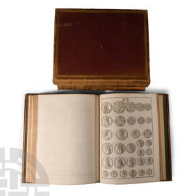
Numismatic Books - Rudding's Coinage of Britain Vol I-III, Plus SuplementTimeLine Auctions Ltd.4.6(183)See Sold PriceMar 09, 2024
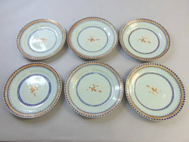
Berkshire by 1847 Rogers Plate Silverplate Salad Set 2- Piece 8 3/4"Mynt Auctions4.6(697)See Sold PriceFeb 26, 2024
Moselle by International Plate Silverplate Large 2pc Carving SetBidhaus4.3(762)See Sold PriceFeb 27, 2024
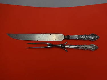
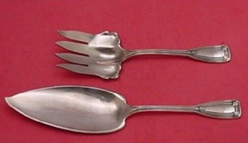
Saint Dunstan By Tiffany Rare Copper Sample Fish Serving Set 2pc One of a KindMynt Auctions4.6(697)See Sold PriceFeb 28, 2024
Kalo Sterling Silver Dessert Set 12pc Handwrought & Hammered B37Mynt Auctions4.6(697)See Sold PriceFeb 29, 2024
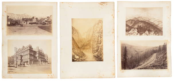
Virginia and West Virginia Topography MapsRapid Estate Liquidators and Auction Gallery4.5(1.1k)See Sold PriceFeb 28, 2024
(3) Copper Print Plates of N. Carolina & TennesseeWilliam Bunch Auctions & Appraisals4.6(878)See Sold PriceFeb 27, 2024


![Untitled. [Eastern U.S., Gulf of Mexico and Caribbean] (1 of 5)](https://p1.liveauctioneers.com/5584/319958/171812128_1_x.jpg?height=282&quality=70&version=1708466739)