MATTHEWS c1856 Map Of Upper Canada Ontario Indian Land Agency Divisions Scarce!Luis Porretta Fine Arts4.3(10)See Sold PriceMar 02, 2024
DEVINE c1856 Dr Salters Map Of Lake Huron Ontario Indian Lands etc. No. 7 ScarceLuis Porretta Fine Arts4.3(10)See Sold PriceMar 02, 2024
DUNLEVIE c1856 Map Counties Of Gaspe & Bonaventure Quebec Canada SCARCE! #1Luis Porretta Fine Arts4.3(10)See Sold PriceMar 02, 2024
DUNLEVIE c1856 Map Counties Of Gaspe & Bonaventure Quebec Canada SCARCE! #2Luis Porretta Fine Arts4.3(10)See Sold PriceMar 02, 2024
Map UNITED COUNTIES LEEDS & GRENVILLE by Walling 1861 Rare Canada Map 5ft x 5ftLuis Porretta Fine Arts4.3(10)See Sold PriceMar 02, 2024
Ambroise TARDIEU c1822 Map Venice Napoleon Italian Campaign 17" x 11"Luis Porretta Fine Arts4.3(10)See Sold PriceMar 02, 2024
SDUK: Antique Map of Florida, 1846Title/Content of Map: 'NORTH AMERICA, XlV., Florida' showing Seminole Indian district & forts. Keys. Date Printed: 1846 Image Size: Approx 42.0 x 33.0cm, 16.5 x 13 inches (Large) Type: Antique steel eSee Sold Price
SDUK: Antique Map of Florida, 1846Title/Content of Map: 'NORTH AMERICA, XlV., Florida' showing Seminole Indian district & forts. Keys. Date Printed: 1846 Image Size: Approx 42.0 x 33.0cm, 16.5 x 13 inches (Large) Type: Antique steel eSee Sold Price
SDUK: Antique Map of Florida, 1846Title/Content of Map: 'NORTH AMERICA, XlV., Florida'. FLORIDA showing Seminole Indian district & forts. Keys. SDUK, 1846 antique map Date Printed: 1846 Image Size: Approx 42.0 x 33.0cm, 16.5 x 13 inchSee Sold Price
SoldSDUK: Antique Map of US Gulf Coast, 1846Title/Content of Map: 'NORTH AMERICA, SHEET XIII., Parts of Louisiana, Arkansas, Mississippi, Alabama & Florida' Native American settlements are named on the map west of the Mississippi, some marked wSee Sold Price
SDUK: Map of Florida showing Seminole Indian districtTITLE/CONTENT OF MAP: 'NORTH AMERICA, XlV., Florida' showing Seminole Indian district & forts. Keys. DATE PRINTED: 1846 IMAGE SIZE: Approx 42.0 x 33.0cm, 16.5 x 13 inches (Large) TYPE: Antique steel eSee Sold Price
SDUK: Antique Map of Africa, 1846TITLE/CONTENT OF MAP: '[no title]' AFRICA South Europe Brazil Gnomonic Projection. Mountains of Kong. Marked on this map are the Mountains of Kong, a non-existent mountain range charted on English mapSee Sold Price
SDUK: Antique Map of Africa, 1846Title/Content of Map: AFRICA South Europe Brazil Gnomonic Projection. Mountains of Kong. Marked on this map are the Mountains of Kong, a non-existent mountain range charted on English maps of Africa fSee Sold Price
SDUK: Antique Map of Quebec, 1846TITLE/CONTENT OF MAP: 'NORTH AMERICA, SHEET II., Lower Canada and New Brunswick with part of New York, Vermont and Maine' Québec Canada Montreal Three Rivers Maine New Brunswick. DATE PRINTED: 1846 ISee Sold Price
SDUK: Antique Map of Ohio, 1846Title/Content of Map: 'NORTH AMERICA, SHEET VIII., Ohio, with parts of Kentucky and Virginia' Date Printed: 1846 Image Size: Approx 39.5 x 34.0cm, 15.5 x 13.5 inches (Large) Type: Antique steel engravSee Sold Price
SoldSDUK: Antique Map of India, 1846TITLE/CONTENT OF MAP: 'INDIA II. Madras Presidency and Mysore' Chennai Canara Carnatic. DATE PRINTED: 1846. This date is printed on the map IMAGE SIZE: Approx 28.0 x 36.5cm, 11 x 14.25 inches (Large)See Sold Price
SoldSDUK: Antique Map of Southwestern USA, 1846CENTRAL AMERICA, SHEET II., INCLUDING TEXAS, CALIFORNIA AND THE NORTHERN STATES OF MEXICO' The map, published in 1846, shows the Republic of Texas as an independent state as it existed between 1836 anSee Sold Price
SDUK: Antique Map of North America, 1846NORTH AMERICA, South to Panama.' The map shows national borders as they existed between 1836 and 1845, including the Republic of Texas as an independent state. It shows the US-Mexican border prior toSee Sold Price
Meyer: Antique Map of Carolinas Georgia Florida, 1846Map: Die Staaten N. & S. Carolina Georgia & Florida Cartographer: Bibliograph. Instituts. Place & Date: Hildburghausen / 1846 Size: 7 3/4" x 10 1/8" Condition: original color; overall age toning A fasSee Sold Price
SoldSDUK: Antique Map of Ancient Egypt, 1846Title/Content of Map: 'ANCIENT EGYPT' Nile Valley ancient names & sites. Original colour. Date Printed: This map was originally engraved in 1831. This date is printed on the map. This edition of the mSee Sold Price
SDUK: Antique Map of Lake Michigan, 1846Title/Content of Map: 'NORTH AMERICA, SHEET V., Parts of Wisconsin and Michigan' Michigan is shown to include only the Lower Peninsula, with the Upper Peninsula being shown as part of Wisconsin. ChicaSee Sold Price
SDUK: Antique Map of Lake Superior, 1846Title/Content of Map: 'NORTH AMERICA, SHEET lV., Lake Superior' Canada USA Ontario Michigan. Fur trading posts. Date Printed: 1846 Image Size: Approx 33.5 x 41.0cm, 13.25 x 16 inches (Large) Type: AntSee Sold Price
SDUK: Antique Map of North America, 1846NORTH AMERICA, South to Panama.' The map shows national borders as they existed between 1836 and 1845, including the Republic of Texas as an independent state. It shows the US-Mexican border prior toSee Sold Price
SDUK: Antique Map of Nova Scotia, 1846Title/Content of Map: 'NORTH AMERICA, SHEET I., NOVA SCOTIA WITH PART OF NEW BRUNSWICK AND LOWER CANADA' Date Printed: 1846 Image Size: Approx 41.0 x 33.5cm, 16.25 x 13.25 inches (Large) Type: AntiqueSee Sold Price
SDUK: Antique Map of South Brazil, 1846Title/Content of Map: 'SOUTH AMERICA, SHEET III., SOUTH BRAZIL WITH PARAGUAY AND URUGUAY' The map includes some interesting brief anecdotes, eg "The Mate chiefly cultivated around Villa Rica" Bahia MiSee Sold Price
SDUK: Antique Map of Lake Michigan, 1846Title/Content of Map: 'NORTH AMERICA, SHEET V., Parts of Wisconsin and Michigan'. Michigan is shown to include only the Lower Peninsula, with the Upper Peninsula being shown as part of Wisconsin. ChicSee Sold Price
SDUK: Antique Map of Lake Michiga, 1846TITLE/CONTENT OF MAP: 'NORTH AMERICA, SHEET V., Parts of Wisconsin and Michigan' Michigan is shown to include only the Lower Peninsula, with the Upper Peninsula being shown as part of Wisconsin. ChicaSee Sold Price
SDUK: Antique Map of South Brazil, 1846Title/Content of Map: 'SOUTH AMERICA, SHEET III., SOUTH BRAZIL WITH PARAGUAY AND URUGUAY' The map includes some interesting brief anecdotes, eg "The Mate chiefly cultivated around Villa Rica" Bahia MiSee Sold Price
SDUK: Antique Map of British India, 1846TITLE/CONTENT OF MAP: 'INDIA' BRITISH INDIA. Lists British French Portuguese Danish states. DATE PRINTED: 1846. This date is printed on the map IMAGE SIZE: Approx 41.0 x 33.5cm, 16.25 x 13 inches (LarSee Sold Price
SDUK: Antique Map of Eastern Siberia, 1846Title/Content of Map: 'EASTERN SIBERIA' Kamtchatka Yakutia Chukotka Khabarovsk. Russia. Date Printed: 1846 Image Size: Approx 35.0 x 41.0cm, 13.75 x 16.25 inches (Large) Type: Antique steel engraved mSee Sold Price
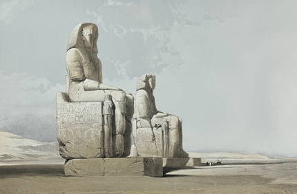
David Roberts - Obelisk of LuxorTrillium Antique Prints & Rare Books4.5(30)See Sold PriceFeb 24, 2024
David Roberts - Approach of the Simoom, Desert of GizehTrillium Antique Prints & Rare Books4.5(30)See Sold PriceFeb 24, 2024
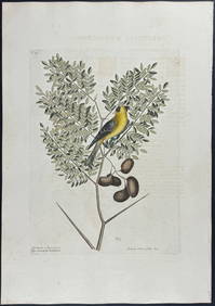
Catesby, Folio - American Goldfinch with Acacia. 1-43Trillium Antique Prints & Rare Books4.5(30)See Sold PriceFeb 24, 2024
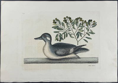
Catesby, Folio - Little Brown Duck with Soap-Wood. 1-98Trillium Antique Prints & Rare Books4.5(30)See Sold PriceFeb 24, 2024
Catesby, Folio - Red Bellied Woodpecker & Hairy Woodpecker with Black Oak. 1-19Trillium Antique Prints & Rare Books4.5(30)See Sold PriceFeb 24, 2024
WEST AFRICA Explorers' routes Senegal Ashanti. Mountains of Kong. SDUK 1857 mapJasper524.5(9.8k)See Sold PriceFeb 28, 2024
AFRICA. Map pre-dating much exploration. Mountains of Kong. SDUK 1851 oldJasper524.5(9.8k)See Sold PriceFeb 28, 2024
NORTH AFRICA OF BABRBARY V Parts of Tripoli & Egypt. Libya Tribes. SDUK 1846 mapJasper524.5(9.8k)See Sold PriceFeb 28, 2024
WEST AFRICA explorers' routes. Beaufort Gray Park Dochard Caillie. SDUK 1874 mapJasper524.5(9.8k)See Sold PriceFeb 28, 2024
NORTH AFRICA BARBARY. Parts of Tripoli (Libya) & Egypt. Tribes. SDUK 1844 mapJasper524.5(9.8k)See Sold PriceFeb 28, 2024
WEST AFRICA I Explorers' routes Senegal Ashanti Ivory Gold Coast. SDUK 1851 mapJasper524.5(9.8k)See Sold PriceFeb 28, 2024
NORTH AFRICA BARBARY. Parts of Tripoli (Libya) & Egypt. Tribes. SDUK 1844 mapJasper524.5(9.8k)See Sold PriceFeb 28, 2024
NIGERIA explorers' routes. Lander Clapperton Oudney Denham Allen. SDUK 1874 mapJasper524.5(9.8k)See Sold PriceFeb 28, 2024
WEST AFRICA II. NIGERIA. Bight of Benin-Lake Chad. Yariba Houssa. SDUK 1851 mapJasper524.5(9.8k)See Sold PriceFeb 28, 2024
NORTH AFRICA OF BABRBARY V Parts of Tripoli & Egypt. Libya Tribes. SDUK 1851 mapJasper524.5(9.8k)See Sold PriceFeb 28, 2024
NIGERIA early explorers' routes. Lake Chad. Yariba Houssa Borgou SDUK 1844 mapJasper524.5(9.8k)See Sold PriceFeb 28, 2024
NORTH AFRICA BARBARY. Parts of Tripoli (Libya) & Egypt. Tribes. SDUK 1848 mapJasper524.5(9.8k)See Sold PriceFeb 28, 2024
WEST AFRICA showing early explorers' routes & Mountains of Kong. SDUK 1844 mapJasper524.5(9.8k)See Sold PriceFeb 28, 2024