SoldScherer World Map North Pole at Center c.1700Title: Repræsentatio Totius Orbis Terraquei Cuius Partes, Quæ Umbra Carent, Fide Catholica Imbutæ Sunt, Reliqæ Omnes Inumbratæ Religionis Catholicæ Expertes Sunt Author: Scherer, Henrich DescripSee Sold Price
Bernard Rhone Acid Etched Metal Plaque"Globe" world map with the North Pole at center. Some small dents, small lacquer loss spots, scuffs, etc. 11.5" x 11.5".See Sold Price
SoldWorld map centered on north pole, 1792Heading: Author: Elwe, Jan Barend Title: Planisphere Representant Toute L'Etendue du Monde dans L'Ordre qu'on suivi dans ce Livre Place Published: Amsterdam Publisher: Date Published: 1792See Sold Price
World map centered on north pole, 1792Heading: Author: Elwe, Jan Barend Title: Planisphere Representant Toute L'Etendue du Monde dans L'Ordre qu'on suivi dans ce Livre Place Published: Amsterdam Publisher: Date Published: 1792See Sold Price
SoldBartholomew, John 1922 Large Map of the North PoleLarge Lithograph Map Published 1922 by The Times, London for "The Times Survey Atlas of the World" Maps by John George Bartholomew of the Edinburgh Geographical Institute. Centre fold as issued. PaperSee Sold Price
MAP, North Pole, RhodeNorth Pole. Johann Christoph Rhode, Tabula Geographica Hemisphaerii Borealis ad Emendatiora quae Adhuc Prodierunt Exempla..., from Atlas Geographicus..., 1753 (circa). Hand Color. This interesting andSee Sold Price
MAP, North Pole, DelisleNorth Pole. Delisle/Dezauche, Hemisphere Septentrional pour voir Plus Distinctement les Terres Arctiques, 1790 (circa). Hand Color. This is a Buache/Dezauche issue of this important map, originally prSee Sold Price
SoldUS Cold War Skull & North Pole Map 26th SquadronAmerican Cold War Stein 1/2L Porcelain. “Patrol Squadron Twenty Six, Top of the World 1956.” Skull and North Pole map. Mint.See Sold Price
1886 World Poles MapAuthor: Hartleben Title: 1886 World Poles Map Materials: Ink on Paper Dimensions: 15.5"X10.5" Description: Hemispherical map of the world dated 1886. This map captures the north and south pole. EngravSee Sold Price
SoldA French opaque glass atomizer modelled as aA French opaque glass atomizer modelled as a terrestrial globe, printed in black and painted in colours, with a map of the world, the North Pole surounted with a brass atomizer fitting, 21cm high, latSee Sold Price
Buffon. Carte Magn‚tique des deux HemisphŠresBuffon (George Louis le Clerc, Comte de) Carte Magn‚tique des deux HemisphŠres,double-hemisphere world map on its polar axis, marking the magnetic north pole as just north of Hudson Bay in CanSee Sold Price
MAP, World, RitterWorld. Franz Ritter, [Untitled - World and Horological Diagrams], 1607 (dated). Hand Color. A rare and extremely unusual map shows the world projected from the North Pole as if it were the table of aSee Sold Price
Ritter Map of North PoleRITTER, Francis (d.1641). Untitled World and Horological Diagrams. Copperplate engraving. Nuremberg: Lochner, 1607. 11" x 13 1/4" sheet, 23" x 24 1/2" framed. A rare and extremely unusual map shows thSee Sold Price
SoldBartholomew, John 1922 North & South Pole, 2 MapsLarge Lithograph Maps Published 1922 by The Times, London for "The Times Survey Atlas of the World" Maps by John George Bartholomew of the Edinburgh Geographical Institute. Centre fold as issued. PapeSee Sold Price
SoldGross, Alexander 1920 Large Maps. North & South PolePair of Large Lithograph Maps Published 1920, London for "The Daily Telegraph Victory Atlas of the World" by Alexander Gross. Centre fold as published. Paper Size: 25 x 19.5 inch (64 x 49cm) Good CondSee Sold Price
Gross, Alexander 1920 Large Maps. North & South PolePair of Large Lithograph Maps Published 1920, London for "The Daily Telegraph Victory Atlas of the World" by Alexander Gross. Centre fold as published. Paper Size: 25 x 19.5 inch (64 x 49cm) Good CondSee Sold Price
SoldBlackie & Weller 1882 Map of the North Pole"North Circumpolar Regions" Lithograph Map Published 1882 by Blackie & Son, London for "The Comprehensive Atlas & Geography of the World" by W. G. Blackie. Maps by Edward Weller. Paper Size: 15 x 11 iSee Sold Price
1882 Map of the North PoleTitle: 1882 Map of the North Pole Author: Blackie Medium: Ink on Paper Dimensions: 15"X11" Description: Map of the North Pole dated 1882. Part of the Comprehensive Atlas & Geography of the World. EngrSee Sold Price
Sold1600s Early Map of the WorldSuperb Early Map of the World Viewed from the North Pole c. 17th Century, POLI ARCTICI [ARCTIC POLE] by Henrici Hondy, Choice Extremely Fine. 17" x 19.5" handcolored copper engraved map, with marginsSee Sold Price
SoldBuache (Philip) Planisphère Physique ou l'on voit duBuache (Philip) Planisphère Physique ou l'on voit du Pole Septentrional..., double-page engraved world map on a North Polar projection, watermark and original hand-colouring, 330 x 450mm, centraSee Sold Price
SoldPolar-Karte Enthaltend: die Lander u. Meere vom NAuthor: Stieler, Adolph Description: Steel-engraved map, hand-colored in outline. 31.5x37.5 cm. (12½x14¾"). The northern half of the northern hemisphere, with the North Pole at the center. Plate 41bSee Sold Price
SoldBuffon (G) Magnétique des HemisphèresBuffon (George Louis le Clerc, Comte de) Carte Magnétique des deux Hemisphères,twin-hemisphere world map designed to display magnetic variation, so centered on the North and South Poles, engraSee Sold Price
SoldLarge Cruchley's New Map of the WorldLondon, England, circa 1858, showing discoveries at the North Pole and the New Settlements in Australia, New Zealand, 24 hand colored engravings on 12.75 x 8.25 inch sheets laid on a foldable paper baSee Sold Price
SoldAir Age Map of The World News StandCentered at the North Pole. 1953. Replogle Globes, Inc. Chicago. Lithography on tin. ; 10 1/2" x 9 3/4"See Sold Price
Crams Map of North Dakota-Complete Railroad System and County Map-1907JM Hobby Supply and Railroad Artifact Auctions4.4(126)See Sold PriceFeb 24, 2024
17TH C. WORLD MAP BY NICOLAES VISSCHER (NETHERLANDS, 1618-1709)Thomaston Place Auction Galleries4.4(386)See Sold PriceFeb 24, 2024
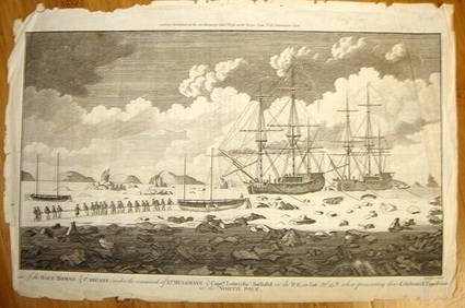
ALEXANDER HOGG ca1790 Engraving Captain Mulgrave Ships Ice Bound Cpt CookLuis Porretta Fine Arts4.3(10)See Sold PriceMar 02, 2024
[ARCTIC]. BOWEN, Emanuel. A New & Accurate Map of the North...Potter & Potter Auctions4.6(539)See Sold PriceMar 07, 2024
Carey, pub. 1796 - Map of the Tennassee State formerly part of North Carolina (Tennessee)Trillium Antique Prints & Rare Books4.5(30)See Sold PriceFeb 24, 2024


![[ARCTIC]. BOWEN, Emanuel. A New & Accurate Map of the North... (1 of 1)](https://p1.liveauctioneers.com/928/318880/171360917_1_x.jpg?height=282&quality=70&version=1707501302)


