ATLAS of ANTIENT GEOGRAPHY by SAMUEL BUTLER 1843John McInnis Auctioneers,LLC4.6(502)See Sold PriceFeb 24, 2024
18TH C. ANTIQUE MAP: FRENCH & INDIAN WAR, FRAMEDThomaston Place Auction Galleries4.4(386)See Sold PriceFeb 24, 2024
Rand McNally Railroad Map Cabinet w/ 21 Railroad MapsRail & Road Auctions4.6(165)See Sold PriceMar 08, 2024
Keith Haring - Ink on New York Map, Best Buddies, Inscribed, Signed, and DatedSapphire Auction Gallery4(67)See Sold PriceMar 02, 2024
LATE 17TH C. FRENCH MAP OF THE NEW WORLD BY ALEXIS-HUBERT JAILLOT (1632-1712)Thomaston Place Auction Galleries4.4(386)See Sold PriceFeb 24, 2024
Central Railroad of New Jersey Map of Sandy Hook Route-ca. 1903JM Hobby Supply and Railroad Artifact Auctions4.4(126)See Sold PriceFeb 24, 2024
Lot of Six Mixed Atlas Box Cars-HO Scale-New in BoxJM Hobby Supply and Railroad Artifact Auctions4.4(126)See Sold PriceFeb 25, 2024
Rand McNally/Santa Fe Railroad Map of Iowa-1912JM Hobby Supply and Railroad Artifact Auctions4.4(126)See Sold PriceFeb 24, 2024
NICOLAES VISSCHER (NETHERLANDS, 1618-1709) MAP OF THE NEW WORLDThomaston Place Auction Galleries4.4(386)See Sold PriceFeb 24, 2024
17TH C. WORLD MAP BY NICOLAES VISSCHER (NETHERLANDS, 1618-1709)Thomaston Place Auction Galleries4.4(386)See Sold PriceFeb 24, 2024
Lot of Six Mixed Atlas Cabooses-HO Scale-New in BoxJM Hobby Supply and Railroad Artifact Auctions4.4(126)See Sold PriceFeb 25, 2024
SoldScarce RR map of Colorado - 1897Scarce and large 2-page map from the very scarce Cram’s 1897 Standard American Railway System Atlas of the World. Cram was unique in producing a special group of atlases for just a few years that hiSee Sold Price
Scarce RR map of Oklahoma/Indian Ters. – 1897Large format map of the rapidly changing neighboring territories. Oklahoma Territory still showing several native reservations, mostly around present day Ponca City, and a single letter named county sSee Sold Price
Fine RR map of Colorado from extremely scarce Cram RR atlasHighly detailed map of Colorado, from Cram's 1910 Standard American Railway System Atlas. Shows counties, railroads, railway stations, township surveys, mountains, rivers, lakes, and a host of other eSee Sold Price
SoldScarce RR map of Ohio, Hardesty 1876Lovely hand colored map from the scarce Jones & Hamilton Historical Atlas of the World Illustrated. Published in 1876 by H. H. Hardesty, this map of Ohio shows and names all the active rail routes preSee Sold Price
Extremely scarce RR map of Utah from 1910 Cram Std. Amer. Railway atlasImpossibly scarce, large format railroad map of Utah, showing counties, railroad lines, towns, mines, rivers, township surveys, Indian reservations, lakes, mountains, creeks, waterfalls, and a host ofSee Sold Price
Scarce RR map of Ohio, Hardesty 1876Lovely hand colored map from the scarce Jones & Hamilton Historical Atlas of the World Illustrated. Published in 1876 by H. H. Hardesty, this map of Ohio shows and names all the active rail routes preSee Sold Price
Lg 2-pg. scarce RR map of Mississippi by Frank A. GrayGray’s New Map of Mississippi by Frank A. Gray with 1878 date (O. W. Gray). Huge, double-page format that allows for incredible detailing. A most impressive map of Mississippi. Shows railroads,See Sold Price
Scarce RR map of early Midwest, H. H. Lloyd 1872Elusive map showing the network of rail lines across a fourteen-state section of the Midwest from the Great Lakes to the Atlantic coast. Published just a few years after the end of the Civil War. IntrSee Sold Price
Scarce RR map of Utah from Gray’s National AtlasGray’s New Map of Utah by Frank A. Gray. From a scarce 1884 edition of Gray’s National Atlas. Shows Indian reservations, deserts, railroads, topography. Clean with a 1.5” tear at topSee Sold Price
Scarce RR map of Iowa from Gray’s National AtlasGray’s New Map of Iowa by Frank A. Gray. Copyright 1877 by O. W. Gray and found in a copy of Gray’s scarce 1884 National Atlas. Shows great detail, with railroads towns, rivers and other iSee Sold Price
Lg 2-pg. scarce RR map of Dakota Territory by GrayGray’s New Map of Dakota, with Part of Manitoba, etc. by Frank A. Gray. Dated 1883 by O. W. Gray. Shows Indian reservations, forts, railroads, hills, rivers, towns. Not a common map. Full originSee Sold Price
Huge and scarce RR map of Kentucky and TennesseeAn extremely large and detailed map of Kentucky and Tennessee. Striking layout with surrounding state areas left blank. (For an interesting comparison check the difference in the design of this map anSee Sold Price
SoldScarce large-scale RR map of Indian TerritoryLarge format Rand McNally & Co’s Railroad Map of Indian Territory published in 1903 delineates each railroad line that was in operation at the time the map was produced. Highly detailed map shows coSee Sold Price
SoldScarce 1882 RR map of New JerseyScarce map of New Jersey from the first mass-produced world atlas by George F. Cram. He published at least two versions of his 1883 Universal Family Atlas, an early edition and a later edition. The eaSee Sold Price
SoldScarce map of Colorado Gold RegionTitle: Map of the gold and silver region of the Pike's Peak, Sierras San Juan and La Plata Author: ** Description: Lithographed map. 34x28 cm. (13½x11").Scarce little map of Colorado Gold Region. witSee Sold Price
Sold1887 Burlington RR Map Eastern ColoradoEastern Colorado.... Sectional map of Nebraska and Eastern Colorado. Published by Burlington Railroad. 1887. Not in Herd or OCLC.See Sold Price
Scarce large-scale RR map of TexasBeautiful and clean large format railroad map with complete view of all railroads operating in the state at the time. Rand McNally & Co’s Railroad Map of Texas published 1903. This highly colorful aSee Sold Price
Scarce Walling’s RR map of the Southern States, 1868Attractive and interesting map of the South including most of Texas, nearly the whole of Indian Territory and all of Florida. Nice illustration of a sailing ship off the northern Florida coast where nSee Sold Price
Extremely scarce 1910 RR map of Montana from little-known atlasAn exceptionally scarce railroad map of Montana from the very last railroad atlas published by the George F. Cram map firm. There are literally only a handful of 1910 Cram Standard American Railway atSee Sold Price
1882 RR map of Colorado from elusive McNally Indexed atlasExcellent map of Colorado with incredible details. Shows railroads, plateaus, topographical features, mines, roads, towns, rivers, etc. From an early 1882 McNally Indexed Atlas of the World. McNally mSee Sold Price
Early scarce map of Colorado Territory, McNally 1881Highly detailed map of Colorado Territory, showing railroads and proposed routes in red and entered onto the map at what appears to be in the last minute before publishing. Shows counties, townships,See Sold Price
Scarce 1850 RR map of Massachusetts & R. IslandStriking map of Massachusetts and Rhode Island, hand colored by counties, from the exceedingly difficult to obtain New Universal Atlas, published 1853 by Thomas, Cowperthwait & Co.. Highlights railroaSee Sold Price
SoldScarce and huge RR map of California – 1898Toward the end of the 19th century, the better atlas makers had pushed the size and quality of their maps to the limit. George F. Cram was one of these publishers, but he also put out a special groupSee Sold Price
Scarce large 1903 RR map of TexasTitle: Scarce large 1903 RR map of Texas Description: Beautiful and clean large format railroad map with complete view of all railroads operating in the state at the time. Rand McNally & Co’s RailroSee Sold Price
Two Michigan Central RR Annual Reports-June 1860 and December 31, 1897JM Hobby Supply and Railroad Artifact Auctions4.4(126)See Sold PriceFeb 24, 2024
Cincinnati Hamilton and Dayton RR Map -USGC 1889JM Hobby Supply and Railroad Artifact Auctions4.4(126)See Sold PriceFeb 24, 2024
Rand McNally Railroad Map of Colorado-1929JM Hobby Supply and Railroad Artifact Auctions4.4(126)See Sold PriceFeb 24, 2024
Union Pacific RR Map of the United States-1926JM Hobby Supply and Railroad Artifact Auctions4.4(126)See Sold PriceFeb 24, 2024
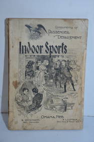
Union Pacific RR 1897 Book-Indoor SportsJM Hobby Supply and Railroad Artifact Auctions4.4(126)See Sold PriceFeb 24, 2024
Union Pacific RR December 14, 1897 Public TimetableJM Hobby Supply and Railroad Artifact Auctions4.4(126)See Sold PriceFeb 24, 2024
DUNLEVIE c1856 Map Counties Of Gaspe & Bonaventure Quebec Canada SCARCE! #2Luis Porretta Fine Arts4.3(10)See Sold PriceMar 02, 2024
DEVINE c1856 Dr Salters Map Of Lake Huron Ontario Indian Lands etc. No. 7 ScarceLuis Porretta Fine Arts4.3(10)See Sold PriceMar 02, 2024
MATTHEWS c1856 Map Of Upper Canada Ontario Indian Land Agency Divisions Scarce!Luis Porretta Fine Arts4.3(10)See Sold PriceMar 02, 2024
DUNLEVIE c1856 Map Counties Of Gaspe & Bonaventure Quebec Canada SCARCE! #1Luis Porretta Fine Arts4.3(10)See Sold PriceMar 02, 2024
CHARLES ROLLIN c1828 Ceasar Hand Colored Africa Military MapLuis Porretta Fine Arts4.3(10)See Sold PriceMar 02, 2024
Battle of the Nile: Disposition of the English & French Fleets, at the Commencement of the Action,Trillium Antique Prints & Rare Books4.5(30)See Sold PriceFeb 24, 2024
AGNES ANNE ABBOT (Massachusetts/Colorado/Germany, 1897-1992), Winter reflections., Watercolor onEldred's4.7(409)See Sold PriceMar 13, 2024
Alphonse Mucha - Job, 1897 - Scarce original lithograph on paper with gold ink!NCAG4.4(32)See Sold PriceMar 10, 2024
Theophile Alexandre Steinlen - Compagnie Francaise des Chocolats et des Thes, 1897NCAG4.4(32)See Sold PriceMar 10, 2024