ATLAS of ANTIENT GEOGRAPHY by SAMUEL BUTLER 1843John McInnis Auctioneers,LLC4.6(504)See Sold PriceFeb 24, 2024
18TH C. ANTIQUE MAP: FRENCH & INDIAN WAR, FRAMEDThomaston Place Auction Galleries4.4(389)See Sold PriceFeb 24, 2024
Rand McNally Railroad Map Cabinet w/ 21 Railroad MapsRail & Road Auctions4.6(165)See Sold PriceMar 08, 2024
Keith Haring - Ink on New York Map, Best Buddies, Inscribed, Signed, and DatedSapphire Auction Gallery4.1(67)See Sold PriceMar 02, 2024
LATE 17TH C. FRENCH MAP OF THE NEW WORLD BY ALEXIS-HUBERT JAILLOT (1632-1712)Thomaston Place Auction Galleries4.4(389)See Sold PriceFeb 24, 2024
Central Railroad of New Jersey Map of Sandy Hook Route-ca. 1903JM Hobby Supply and Railroad Artifact Auctions4.4(126)See Sold PriceFeb 24, 2024
Lot of Six Mixed Atlas Box Cars-HO Scale-New in BoxJM Hobby Supply and Railroad Artifact Auctions4.4(126)See Sold PriceFeb 25, 2024
Rand McNally/Santa Fe Railroad Map of Iowa-1912JM Hobby Supply and Railroad Artifact Auctions4.4(126)See Sold PriceFeb 24, 2024
NICOLAES VISSCHER (NETHERLANDS, 1618-1709) MAP OF THE NEW WORLDThomaston Place Auction Galleries4.4(389)See Sold PriceFeb 24, 2024
17TH C. WORLD MAP BY NICOLAES VISSCHER (NETHERLANDS, 1618-1709)Thomaston Place Auction Galleries4.4(389)See Sold PriceFeb 24, 2024
Lot of Six Mixed Atlas Cabooses-HO Scale-New in BoxJM Hobby Supply and Railroad Artifact Auctions4.4(126)See Sold PriceFeb 25, 2024
SoldRobert Morden. China: a New Description. 1693Robert Morden. China: a New Description. London, 1693. Impression measures 4.5x5.25'' on approx 6x7'' sheet. From Morden's Atlas Terrestris, Third Edition. Pinholes at top corners(35)See Sold Price
SoldRobert Morden. China: a New Description. 1690Robert Morden. China: a New Description. London, 1690. Impression measures 4.5x5'' on 8x6'' page. Foxing around edges, linen tape at top center.(10)See Sold Price
SoldMorden's New Mexico California an island 1693Title: New Mexico vel New Granata et Marata et California Author: Morden, Robert Description: Copper-engraved map. 10.4x12.5 cm. on sheet 19.5x15.7 cm., with text on lower half.Little map of the SouthSee Sold Price
SoldA small mixed group of English county maps,comprising Cornwall by Robert Morden for 'New Description and State of England', 1701; Northumbriæ Comitatus by Saxton and Hole, and Huntingdon Comitatus by Saxton and Kip, both for Camden's BritSee Sold Price
A small mixed group of English county maps,comprising Cornwall by Robert Morden for 'New Description and State of England', 1701; Northumbriæ Comitatus by Saxton and Hole, and Huntingdon Comitatus by Saxton and Kip, both for Camden's BritSee Sold Price
A small mixed group of English county maps,comprising Cornwall by Robert Morden for 'New Description and State of England', 1701; Northumbriæ Comitatus by Saxton and Hole, and Huntingdon Comitatus by Saxton and Kip, both for Camden's BritSee Sold Price
SoldMiniature map of Asia by Robert Morden 1688Title: Asia. A New Description Author: Morden, Robert Description: Copper-engarved map, hand-colored (later); hinged to mat, framed under plexiglass.Little map of Asia clipped from a leaf that also coSee Sold Price
SoldRobert Morden 4 engraved mapsRobert Morden- ''Map of Durham''; ''Bedfordshire''; ''Chesire''; and ''Cumberland''- 4 engraved maps, was first published in 1701, from The New Description & State of England, paper toning, otherwiseSee Sold Price
SoldMorden, Robert 1701 Hand Col Map of Staffordshire, UKHand Colored Copper Engraved Map Published 1701-08, London for "The New Description and State of England, containing the Mapps of the Counties of England and Wales" by Robert Morden. Light folds as isSee Sold Price
SoldTwo 18th C. Maps & Two 18th C. EngravingsLot consists of three 18th century engravings--1st item: Mid 18th century map titled "A New Map of Carolina by Robert Morden"; page taken from a book or publication "A Description of Carolina"; map siSee Sold Price
SoldThree Early Maps of South Carolina/North Carolina1. Mid 18th century map titled "A New Map of Carolina by Robert Morden"; page taken from a book or publication "A Description of Carolina"; map size approximately 5" x 5"; page size 6 3/8"W, 8"H; 2. MSee Sold Price
Sold(Geography), Morden, Robert (c.1650-1703) Geograph(Geography), Morden, Robert (c.1650-1703) Geography Rectified: or, A Description of the World, London: Printed for Robert Morden and Thomas Cockerill, at the Atlas in Cornhill, 1693, third edition, coSee Sold Price
SoldMorden's New Mexico California an island c.1700Title: New Mexico vel New Granata et Marata et California Author: Morden, Robert Description: Copper-engraved map. 10.4x12.5 cm. on sheet 20.2x15.7 cm., with text on lower half; hinged to mat.Little mSee Sold Price
Morden's America with California an islandTitle: America by R. Morden Author:Morden, Robert Description:Copper-engraved map. 10.5x12.2 cm. (4x5"), matted. Small, rather crude map of North and South America, with California an island. Named "CSee Sold Price
SoldSix maps of English CountiesTitle: Six maps of English Counties from Camden's Britannia Author: Morden, Robert Description: Includes: The County of Monmouth. (Old repair to tear, a few unrepaired.) * The East Riding of YorkshireSee Sold Price
Smaller Islands in the British OceanTitle: The Smaller Islands in the British Ocean Author: Morden, Robert Description: Copper-engraved map, later hand-coloring. 36x42 cm. (14x16½"), matted.Shows the Isle of Wight, Alderney, Guernsey,See Sold Price
Maps of England by Robert Morden c.1695Title: Collection of 7 maps of England and her parts by Robert Morden Author: Morden, Robert Description: Includes: England. (Verso repair along centerfold, a few other repairs.) * England. (Split halSee Sold Price
SoldMorden, Robert. A New Map of CarolinaMorden, Robert. A New Map of Carolinacopperplate leaf with hand color from Geography Rectified (London, circa 1688-1700), the sheet with descriptive text on both sides. Presented under mat. 7.25 x 6.2See Sold Price
SoldMORDEN, ROBERT. A New Map of New England and New York.MORDEN, ROBERT. A New Map of New England and New York. Small-scale engraved map of New England on a folio leaf of English text. 8x6½ inches sheet size; preceding text leaf tipped to verso. - LondSee Sold Price
SoldEarly Map of New England: Robert MordenReproduced from the Original in the John Carter Brown Library, Brown University, Circa 1960's. Colored Collotype, Title: A map of New England, New Yorke, New Jersey, Virginia and Maryland Sold By RobeSee Sold Price
Sold[Wales]. [Morden, Robert]. A New And Correct Map[Wales]. [Morden, Robert]. A New And Correct Map Of North Wales. [Lon]: 1722. Image 14 x 17 inches, later outline color. Sight condition very good, housed in plain wood frame. This is a live auction aSee Sold Price
SoldMORDEN, ROBERT. A New Map of ye World.MORDEN, ROBERT. A New Map of ye World. Miniature engraved double-hemisphere world map showing California as an island and with allegories of the four seasons represented in the corner spandrels. 6x7&#See Sold Price
Morden (Robert) A New and Correct Map of North-WalMorden (Robert) A New and Correct Map of North-Wales,engraved map with hand-colouring, 360 x 430mm, central vertical fold, minor surface dirt, Abel Swale, Awnsham and John Churchill, [1695 orSee Sold Price
SoldMorden - A New Map of VirginiaRobert Morden (d. 1703), A New Map of Virginia By Robt. Morden, 1688/1689 from Atlas Terrestris (state 2), black and white line engraving on laid paper with period hand color, 5 x 4-3/4 in. (lines),See Sold Price
Massive Tiffany & Co Copeland Spode Blue Willow Charger English China Serving Plate PlatterHess Fine Auctions4.5(202)See Sold PriceMar 02, 2024
Portfolio of 15 County Maps by Robert Morden (English 1650-1703)Nadeau's Auction Gallery4.7(405)See Sold PriceFeb 24, 2024
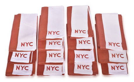
13 New York Central Railroad Mercury Embroidered NapkinsRail & Road Auctions4.6(165)See Sold PriceMar 07, 2024
Four New York Central "Mercury" Embroidered Dining Car Table ClothsRail & Road Auctions4.6(165)See Sold PriceMar 07, 2024
Map: An 18thC engraved and hand coloured map of Buckinghamshire after Robert Morden. Approx. 8 1/4"Claydon Auctioneers Ltd4.3(125)See Sold PriceFeb 26, 2024
Map: A 17thC engraved and hand coloured map of Bedfordshire after Robert Morden. Approx. 12 1/2" xClaydon Auctioneers Ltd4.3(125)See Sold PriceFeb 26, 2024
Robert Indiana, New York State Theater Lincoln Center, Screenprint PosterRoGallery4.5(81)See Sold PriceFeb 29, 2024
Edited by Robert Mankoff, The Complete Cartoons of the New YorkerChurchill Galleries3.7(216)See Sold PriceFeb 26, 2024
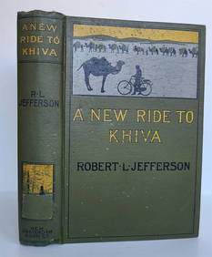
1900 ROBERT JEFFERSON'S ANTIQUE ILLUSTRATED BOOK A NEW RIDE TO KHIVANY Elizabeth 4.3(85)See Sold PriceMar 03, 2024
Myotts England - Royal Grafton China - Tea Cup and Saucer - Grand Falls, New BrunswickRapid Estate Liquidators and Auction Gallery4.5(1.1k)See Sold PriceMar 02, 2024
Rare Green Copeland Staffordshire Equestrian Well & Tree PlatterJasper524.5(9.8k)See Sold PriceMar 07, 2024
1844 "Chambers's Edinburgh Journal, Volume 1"Rapid Estate Liquidators and Auction Gallery4.5(1.1k)See Sold PriceMar 03, 2024


![[Wales]. [Morden, Robert]. A New And Correct Map (1 of 1)](https://p1.liveauctioneers.com/179/2417/1045280_1_x.jpg?height=282&quality=70)