SoldTerrestrial Globe and Armillary SphereTerrestrial Globe and Armillary Sphere Two items wood stands, by Charles François Delamarche after Didier Robert de Vaugondy (French, 1723-1786) having applied paper on fabricated wood construction,See Sold Price
SoldROBERT DE VAUGONDY (FRENCH, 1723-1786) MAP OF THEROBERT DE VAUGONDY (FRENCH, 1723-1786) MAP OF THE MID-ATLANTIC REGION, hand-colored engraving on paper, titled "Partie de L'Amerique Septentrionale qui comprend Le Cours de L'Ohio, la Nlle. AngleterreSee Sold Price
SoldDIDIER ROBERT DE VAUGONDY (FRENCH, 1723-1786) MAP OFDIDIER ROBERT DE VAUGONDY (FRENCH, 1723-1786) MAP OF VIRGINIA AND MARYLAND hand-colored engraving on laid paper, "Carte De La Virginie, Et Du Maryland", from De Vaugondy's "Atlas Universel", publishedSee Sold Price
SoldHand Colored Map "Carte Du Nouveau Continent"Hand colored map "Carte Du Nouveau Continent" engraved by Ambrose Tardier (French, 1788-1841), designed by Didier Robert De Vaugondy (French, 1723-1786). Framed, not examined out of frame. Stains, folSee Sold Price
SoldVAUGONDY ENGRAVING MAP CHARLEMAGNE EMPIRE, 18TH C.Unframed map, engraving on paper, "Imperium Caroli Magni Occidentis Imperatoris," Didier Robert de Vaugondy (French, 1723-1786), cartouche with title in upper left corner, held aloft by winged putti,See Sold Price
SoldDIDIER ROBERT DE VAUGONDY (FRENCH, 1723-1786) MAP OFDIDIER ROBERT DE VAUGONDY (FRENCH, 1723-1786) MAP OF EASTERN AMERICA AND THE OHIO RIVER VALLEY hand-colored engraving on laid paper, "Partie De L'Amerique Septentrionale qui comprend Le Cours De L'OhiSee Sold Price
SoldMap, Didier Robert de VaugondyDidier Robert de Vaugondy (French, 1723-1786), "Carte De La Californie Et Des Pays Nord Ouest," (1772), copper engraved map with hand coloring, image: 12"h x 13"w, sheet (unframed): 15.25"h x 17.5"wSee Sold Price
SoldDidier Robert de Vaugondy Partie De L'AmeriqueDidier Robert de Vaugondy Partie De L'Amerique Septentrionale... French, ca. 1755. Didier Robert de Vaugondy, (French, 1723-1786), Gilles Robert de Vaugondy (French, 1688-1766). Map of the American coSee Sold Price
SoldRobert de Vaugondy (French, 1723-1786)Robert de Vaugondy (French, 1723-1786), "Cartes des Pays connus sous le nom de Canada dans laquelle sont distinguées les possessions françoises & Angl....", 1753, copper-engraved map, hand-colored iSee Sold Price
SoldRobert de Vaugondy (French, 1723-1786)Robert de Vaugondy (French, 1723-1786), "Carte Generale de l'Empire des Russes en Europe et en Asie...", 1753, engraved map on two sheets (not joined), hand-colored in outline, with elaborate cartouchSee Sold Price
SoldRobert de Vaugondy (French, 1723-1786)Robert de Vaugondy (French, 1723-1786), "Carte Generale de l'Empire des Russes en Europe et en Asie...", 1753, engraved map on two sheets (not joined), hand-colored in outline, with elaborate cartouchSee Sold Price
SoldRobert de Vaugondy (French, 1723-1786)Robert de Vaugondy (French, 1723-1786), "Carte Generale de l'Empire des Russes en Europe et en Asie...", 1753, engraved map on two sheets (not joined), hand-colored in outline, with elaborate cartouchSee Sold Price
SoldRobert de Vaugondy (French, 1723-1786)Robert de Vaugondy (French, 1723-1786), "Carte Generale de l'Empire des Russes en Europe et en Asie...", 1753, engraved map on two sheets (not joined), hand-colored in outline, with elaborate cartouchSee Sold Price
SoldR. De Vaugondy MapRobert De Vaugondy, Didier, French, 1723-1786. Engraved map with Hand colored outlines depicts "Partie de l'Amerique Septent? qui comprend la Nouvelle France ou le Canada". Not examined out of the fraSee Sold Price
Vaugondy, Splendid Map of the Chinese Empire, Paris,Didier Robert de Vaugondy (1723-1786) – Geographer of the French King Louis XV and the Duke of Lorraine 'L`Empire de la Chine' – Large and splendid colored copper map of the Chinese Empire PrintedSee Sold Price
Sold(2) 18TH CENTURY FRENCH & GERMAN MAPS(lot of 2) Maps; (1) framed map from the "Atlas Universal" by Gilles Robert de Vaugondy and son (France, c.1723-1786), entitled "Gouvernement General de L'Isle de France, divise par Pays, Par le Sr. RSee Sold Price
SoldORNATE 1757 TITLE PAGE, "ATLAS UNIVERSALE"Ornately engraved title page to the "Atlas Universale", engraved by Jean Charles Baquoy (French, 1721-1777) for Dieder Robert de Vaugondy (1723-1786), the atlas published in 1757, featuring figures frSee Sold Price
SoldDidier Robert de Vaugondy (1723 - 1786), two-fold map,Didier Robert de Vaugondy (1723 - 1786), two-fold map, Etats du Grand-Seigneur en Asie, Empire de Perse, Pays des Usbecs, Arabie et Egypte, [Paris] 1753, allegorical title cartouche to lower left-handSee Sold Price
SoldDidier Robert de Vaugondy (1723 - 1786), two-fold map,Didier Robert de Vaugondy (1723 - 1786), two-fold map, Etats du Grand-Seigneur en Asie, Empire de Perse, Pays des Usbecs, Arabie et Egypte, [Paris] 1753, allegorical title cartouche to lower left-handSee Sold Price
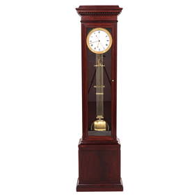
SoldDELAMARCHE, Charles Francois (1740-1817) -- Robert deDELAMARCHE, Charles Francois (1740-1817) -- Robert de VAUGONDY (1723-1786). Institutions Geographiques, ou Description Generale du Globe Terrestre. Parigi: rue du Foin S. Jacques, au Collège de M. GeSee Sold Price
SoldAMERIQUE SEPTENTRIONALE MAP PUBLISHED IN 1750 CORRAMERIQUE SEPTENTRIONALE MAP PUBLISHED IN 1750 CORRECTED IN 1775 BY ROBERT DE VAUGONDY (1723-1786), with an inset map of the Discoveries of Admiral de Forte in the North Pacific. 19" x 23 1/4". Framed.See Sold Price
SoldMap- Robert de Vaugondy (1723-1786). "AmeriqueMap- Robert de Vaugondy (1723-1786). "Amerique Septentrionale," 1750, hand colored, with a cartouche of Tropical plants, natives and wildlife surrounding the title, shrink wrapped, H.- 21 3/8 in., W.-See Sold Price
SoldAMERIQUE SEPTENTRIONALE MAP PUBLISHED IN 1750 CORRAMERIQUE SEPTENTRIONALE MAP PUBLISHED IN 1750 CORRECTED IN 1775 by Robert De Vaugondy 1723-1786 with an inset map of the Discoveries of Admiral de Forte in the North Pacific. 19 x 23 1/4". Framed.See Sold Price
Vaugondy Amerique SepentrionaleAmerique Septentrionale. Didier Robert de Vaugondy (1723-1786) & Gilles Robert de Vaugondy (1688-1766). Engraved map with hand color in outline. Paris, 1750. 21 1/2 x 32 1/2 inches sheet.See Sold Price
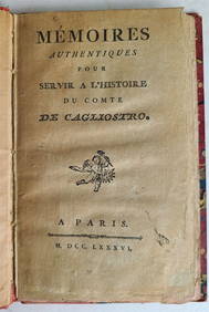
[CAGLIOSTRO]. MARCUARD, R.S. (d. 1788) Comte de Cagliostro....Potter & Potter Auctions4.6(539)See Sold PriceFeb 24, 2024
Robert Delaunay (French, 1885–1941) - Portrait de Madame Jacques HeimFreeman's | Hindman4.5(158)See Sold PriceFeb 27, 2024
ROBERT COMBAS – L’AMOUR EST UN BOUQUET DE VIOLETTES - ACRYLIC ON CANVAS- IN THE STYLE OFThe Art's World4.3(1)See Sold PriceFeb 27, 2024
Van Dongen. Les plus beaux contes de KIPLING, 1920. 23 pochoirs in color.TheRedFinch Auctions4.4(24)See Sold PriceFeb 29, 2024
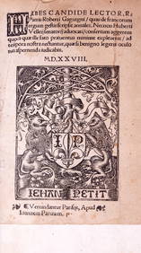
Gaguin (Robert) De Francorum Regum Gestis Scripsit Annales, Paris, Jehan Petit, Pierre Vidoué andForum Auctions4.3(52)See Sold PriceFeb 29, 2024
1826 Memoires De Robert Guillemard Hardcover BookRapid Estate Liquidators and Auction Gallery4.5(1.1k)See Sold PriceFeb 25, 2024
COUNT ALESSANDRO CAGLIOSTRO'S 1786 BIOGRAPHY, AN OLD FRENCH OCCULTNY Elizabeth 4.3(84)See Sold PriceMar 03, 2024
DUCHAMP MARCEL: (1887-1968)International Autograph Auctions Europe S.L.4.5(52)See Sold PriceMar 14, 2024
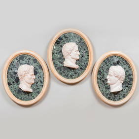
Three Verde Antico Marble, Plaster and Painted Wood Profile Portraits of CaesarsSTAIR4.6(286)See Sold PriceMar 06, 2024
Robert de Vaugondy - Map of Canada - Mer de l' Ouest or Sea of the West and a Northwest PassageProverde Auctions4.3(3)See Sold PriceFeb 28, 2024
Robert Neal Hind Engraving Duke Of CambridgeRapid Estate Liquidators and Auction Gallery4.5(1.1k)See Sold PriceFeb 27, 2024
FUNCTIONS OF THE NERVOUS SYSTEM. 8 French imprints on nerves, reflexes and movement.Bonhams4.1(305)See Sold PriceJun 18, 2024


![[CAGLIOSTRO]. MARCUARD, R.S. (d. 1788) Comte de Cagliostro.... (1 of 1)](https://p1.liveauctioneers.com/928/317913/170625899_1_x.jpg?height=282&quality=70&version=1706650066)