Marc Chagall-Limited Edition -Paris Opera Ceiling after ChagallArt Legacy Auctions4.5(217)See Sold PriceFeb 24, 2024
Salvador Dali Pantagruel Limited Edition Lithograph Hand signed and numberedArt Legacy Auctions4.5(217)See Sold PriceFeb 24, 2024
Pablo Picasso Bouquet of Peace Collection Domaine Picasso Limited Edition on paper.Art Legacy Auctions4.5(217)See Sold PriceFeb 24, 2024
A RARE MAXFIELD PARRISH JACK AND THE BEANSTALK PRINTSoulis Auctions4.8(953)See Sold PriceFeb 24, 2024
LARGE MECHANICAL PRINT 'STARS' AFTER MAXFIELD PARRISHSoulis Auctions4.8(953)See Sold PriceFeb 24, 2024
Heinrich Aldegrever, etc. 15 old master prints. 16th-17th centuries. Aldegrever works include "ManTremont Auctions4.6(293)See Sold PriceFeb 25, 2024
SoldR. De Vaugondy MapRobert De Vaugondy, Didier, French, 1723-1786. Engraved map with Hand colored outlines depicts "Partie de l'Amerique Septent? qui comprend la Nouvelle France ou le Canada". Not examined out of the fraSee Sold Price
SoldVAUGONDY, R. de / DELAMARCHE MAPLa Monarchie des Hebreux sous Salamon, ou le royaume. A fine example of Delamarche's exceptional 1745 map of the Holy Land, Israel, or Palestine. Details the region on both sides of the Jordan River wSee Sold Price
[?R de Vaugondy (G & D)] [Gulf of Bengal][?Robert de Vaugondy (Gilles & Didier)] [Gulf of Bengal], engraved map of the Gulf of Bengal with southern India, Ceylon, Thailand and Malaya, inset maps of the mouth of the Ganges, environs oSee Sold Price
SoldCarte Des Nouvelles Decouvertes...(Plus) Extrait D'uneTitle/Content of Map: Carte Des Nouvelles Decouvertes...(Plus) Extrait D'une Carte Japonoise De L'univers... Date: 1772 Cartographer: DeVaugondy, R. Size: 11.4X13.9 Maps of n.e. Asia, Japan & n.w. N.See Sold Price
Carte Generale Des Decouvertes De L'admiral DeTitle/Content of Map: Carte Generale Des Decouvertes De L'admiral De Fonte...1752 Date: 1772 Cartographer: DeVaugondy, R. Publisher: DeVaugondy, R. Size: 11.3Height - 14.7Width From: Diderot's Encycl.See Sold Price
Carte Generale Des Decouvertes De L'admiral DeTitle: Carte Generale Des Decouvertes De L'admiral De Fonte...1752 Publication Date: 1772 Cartographer: DeVaugondy, R. Publisher: DeVaugondy, R. Size: 11.3Height - 14.7Width From: Diderot's Encycl.? MSee Sold Price
Carte Generale Des Decouvertes De L'admiral De Fonte...1752Title: Carte Generale Des Decouvertes De L'admiral De Fonte...1752 Cartographer: DeVaugondy, R. Publisher: DeVaugondy, R. Height: 11.3 Width: 14.7 From: Diderot's Encycl.? Map depicting Fonte's and otSee Sold Price
Carte Generale Des Decouvertes De L'admiral DePublication Date: 1772 Title: Carte Generale Des Decouvertes De L'admiral De Fonte...1752 Cartographer: DeVaugondy, R. Publisher: DeVaugondy, R. Height: 11.3 Width: 14.7 From: Diderot's Encycl.? Map dSee Sold Price
Sold3 18th C. maps incl. R. Vaugondy and J. BaylyItem 1: Robert de Vaugondy hand colored map "Amerique septen trionale." French, 1750. 6 3/8" H x 6 1/2" W. Item 2: Robert de Vaugondy hand colored map "Mappe Monde" French, 1750. 6 3/8" H x 12 1/8" W.See Sold Price
de Vaugondy, R. Partie de l 'Amerique SeptentrionaleVaugondy, Robert de Partie de l'Amerique Septentrionale 1757 Copperplate engraving; outline coloured Printed area: 50 x 61 cm; 19.7 x 24 in Map of Newfoundland, Nova Scotia and the entire river of St.See Sold Price
de Vaugondy, R. Amerique Septentrionale RelationsVaugondy, Robert de Amerique Septentrionale dressee sur les Relations les plus modernes des Voyageurs et Navigateurs ou se remarquent les Etats Unis 1783 Copperplate engraving; outline coloured PrinteSee Sold Price
Carte Generale Des Decouvertes De L'admiral DeTitle/Content of Map: Carte Generale Des Decouvertes De L'admiral De Fonte...1752 Date: 1772 Cartographer: DeVaugondy, R. Size: 11.3X14.7 From: Diderot's Encycl.? Map depicting Fonte's and others' traSee Sold Price
Soldmaps, Germany, Africa, Robert de Vaugondy(lot of 2) Framed hand-colored engraved maps: African Coast around the Gulf of Guinea, by Lattre and R. Bonne; Germany, by Robert de VaugondySee Sold Price
Map of ScotlandTitle: Map of Scotland Artist: R.de Vaugondy Medium: ink on paper Dimensions: 18" x 12" Map of Scotland dated 1812. Hand drawn by Robert de Vaugondy. Engraved on a steel plate. Corrections done by C.See Sold Price
Santini / Vaugondy: Antique Map of Egypt, 1784Title/Content of Map: 'Carte de l'Egypte Ancienne et Moderne Dressée sur Celle du R.P. Sicard et autres assujetties aux observations astronomiques. Par le Sr. Robert de Vaugondy. À Venise par P. SanSee Sold Price
Carte de l'Egypte Ancienne et Moderne. Nile valley. Sinai. VAUGONDY 1753 mapTITLE OF MAP (NOT PRINTED ON THE PAGE):'Carte de l'Egypte Ancienne et Moderne, dressee sur celle du R.P. Sicard et autres, assujetties aux observations astronomiques, par le Sr. Robert de Vaugondy G&#See Sold Price
French map "Carte de L'Egypte Ancienne etA French map "Carte de L'Egypte Ancienne et Moderne" (Dresse sur celle du R.P. Sicard d autres, assujellies aux observations astronomique), by Robert de Vaugondy, 1753, 27 1/2" x 20 1/2" (sight), framSee Sold Price
Carte de l'Egypte Ancienne et Moderne. SANTINI / ROBERTTITLE/CONTENT OF MAP: 'Carte de l'Egypte Ancienne et Moderne Dressée sur Celle du R.P. Sicard et autres assujetties aux observations astronomiques. Par le Sr. Robert de Vaugondy. À Venise par P. SanSee Sold Price
Robert de Vaugondy: Map of Judea, the Holy Land, 1657Carte de la Terre de Canaan ou Terre Promise a Abraham et la Posterite dans Laquelle on a Trace la fortie du people…. By: Robert de Vaugondy Date: 1657 (circa) Paris Dimensions: 18.75 x 23 inches (4See Sold Price
Sold1749 Robert de Vaugondy Map of Great Lakes Region --Title/Content of Map: 1749 Robert de Vaugondy Map of Great Lakes Region -- Les Lacs du Canada et Nouvelle Angleterre Date: 1749, Paris Cartographer: G Robert de Vaugondy Size: 6.5 X 8,5 in. This is anSee Sold Price
SoldAntique Robert De Vaugondy Map of Ancient ItalyAntique Robert De Vaugondy Map of Ancient Italy. Profesionally matted and framed. 28.75 inches x 31.5 inches.See Sold Price
Sold18th c. de Vaugondy Map of Virginia and MarylandDouble-page hand-colored engraved folio, titled "Carte de la Virginie et du Maryland", Robert de Vaugondy, Paris, circa 1755. Based on a map by Joshua Fry and Peter Jefferson, sight size: 21 1/8 x 31See Sold Price
SoldDiderot and de Vaugondy Map of California ca. 177Denis Diderot (1713-1784) and Didier Robert de Vaugondy (ca. 1723–1786), "Carte De La Californie Suivant I. la Carte manuscrite de l'Amerique de Mathieu Neron Pecci olen dresee a Florence en 16See Sold Price
Robert de Vaugondy: Map of Poland With Privilege 1750Original title: Pologne par le Sr. Robert de Vaugondy. Avec Privilege 1750 Cartographer: Gilles Robert de Vaugondy 6 x 6.5 inches. Hand colored. Dated 1750 on the title, this version was published inSee Sold Price
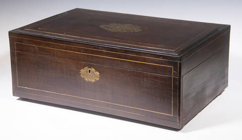
FRENCH INLAID MAHOGANY JEWELRY CHESTThomaston Place Auction Galleries4.4(386)See Sold PriceFeb 25, 2024
Roger de la Fresnaye (French, 1885-1925) - Ève AssiseFreeman's | Hindman4.5(158)See Sold PriceFeb 27, 2024
Roger de la Fresnaye (French, 1885-1925) - Nu DeboutFreeman's | Hindman4.5(158)See Sold PriceFeb 28, 2024
After Matthaus Merian (1593-1650), Engraving with hand colouring, Ander Prost: der Kirche de R. P.Claydon Auctioneers Ltd4.3(125)See Sold PriceFeb 26, 2024
Buffon, Vaugody & Bell 1785 America - Map of the New ContinentAlbion Auctions4.6(336)See Sold PriceMar 01, 2024
Buffon, Vaugody & Bell 1785 Map of the Old Continent. Africa, AsiaAlbion Auctions4.6(336)See Sold PriceMar 01, 2024
Robert de Vaugondy - Map of Canada - Mer de l' Ouest or Sea of the West and a Northwest PassageProverde Auctions4.3(3)See Sold PriceFeb 28, 2024


![[?R de Vaugondy (G & D)] [Gulf of Bengal] (1 of 1)](https://p1.liveauctioneers.com/410/3027/1300249_1_x.jpg?height=282&quality=70)