ATLAS of ANTIENT GEOGRAPHY by SAMUEL BUTLER 1843John McInnis Auctioneers,LLC4.6(502)See Sold PriceFeb 24, 2024
18TH C. ANTIQUE MAP: FRENCH & INDIAN WAR, FRAMEDThomaston Place Auction Galleries4.4(386)See Sold PriceFeb 24, 2024
Rand McNally Railroad Map Cabinet w/ 21 Railroad MapsRail & Road Auctions4.6(165)See Sold PriceMar 08, 2024
Keith Haring - Ink on New York Map, Best Buddies, Inscribed, Signed, and DatedSapphire Auction Gallery4(67)See Sold PriceMar 02, 2024
LATE 17TH C. FRENCH MAP OF THE NEW WORLD BY ALEXIS-HUBERT JAILLOT (1632-1712)Thomaston Place Auction Galleries4.4(386)See Sold PriceFeb 24, 2024
Central Railroad of New Jersey Map of Sandy Hook Route-ca. 1903JM Hobby Supply and Railroad Artifact Auctions4.4(126)See Sold PriceFeb 24, 2024
Lot of Six Mixed Atlas Box Cars-HO Scale-New in BoxJM Hobby Supply and Railroad Artifact Auctions4.4(126)See Sold PriceFeb 25, 2024
Rand McNally/Santa Fe Railroad Map of Iowa-1912JM Hobby Supply and Railroad Artifact Auctions4.4(126)See Sold PriceFeb 24, 2024
NICOLAES VISSCHER (NETHERLANDS, 1618-1709) MAP OF THE NEW WORLDThomaston Place Auction Galleries4.4(386)See Sold PriceFeb 24, 2024
17TH C. WORLD MAP BY NICOLAES VISSCHER (NETHERLANDS, 1618-1709)Thomaston Place Auction Galleries4.4(386)See Sold PriceFeb 24, 2024
Lot of Six Mixed Atlas Cabooses-HO Scale-New in BoxJM Hobby Supply and Railroad Artifact Auctions4.4(126)See Sold PriceFeb 25, 2024
SoldRobert De Vaugondy 1772 Map of ParisRobert De Vaugondy 1772 "Plan De La Ville Et Des Faubourg De Paris" hand colored map and directory of Paris 22 x 32" mild toning, some creases as issued, minor losses along right marginSee Sold Price
Sold1772, Map of Kamchatka by Robert De VaugondyHistoric Maps 1772 Map of Kamchatka By Robert De Vaugondy 1772, Map, NOUVELLE REPRESENTATION DES COTES NORD ET EST DE L’ASIE..., by Robert De Vaugondy, Paris, Very Fine. Copper-engraved Map with twoSee Sold Price
Sold1772, Map of Kamchatka by Robert De VaugondyHistoric Maps 1772 Map of Kamchatka By Robert De Vaugondy 1772, Map, NOUVELLE REPRESENTATION DES COTES NORD ET EST DE L’ASIE..., by Robert De Vaugondy, Paris, Very Fine. Copper-engraved Map with twoSee Sold Price
Sold1772, Map by Robert De VaugondyMaps1772, NOUVELLE REPRESENTATION DES COTES NORD ET EST DE L’ASIE..., by Robert De Vaugondy, Paris, Very Fine. 11.5” x 15”, uncolored, copper-engraved map with two large insets, whicSee Sold Price
Sold1772, Map by Robert De VaugondyMaps1772, NOUVELLE REPRESENTATION DES COTES NORD ET EST DE L’ASIE..., by Robert De Vaugondy, Paris, Very Fine. 11.5” x 15”, uncolored, copper-engraved map with two large insets, whicSee Sold Price
Sold1772, Map by Robert De VaugondyMaps1772, NOUVELLE REPRESENTATION DES COTES NORD ET EST DE L’ASIE..., by Robert De Vaugondy, Paris, Very Fine. 11.5” x 15”, uncolored, copper-engraved map with two large insets, whicSee Sold Price
Sold1772, Map by by Robert De VaugondyMaps1772, NOUVELLE REPRESENTATION DES COTES NORD ET EST DE L’ASIE..., by Robert De Vaugondy, Paris, Very Fine. 11.5” x 15”, uncolored, copper-engraved map with two large insets, whicSee Sold Price
Sold1772, Map by by Robert De VaugondyMaps1772, NOUVELLE REPRESENTATION DES COTES NORD ET EST DE L’ASIE..., by Robert De Vaugondy, Paris, Very Fine. 11.5” x 15”, uncolored, copper-engraved map with two large insets, whicSee Sold Price
Sold1772, Map by by Robert De Vaugondy1772, NOUVELLE REPRESENTATION DES COTES NORD ET EST DE L'ASIE..., by Robert De Vaugondy, Paris, Very Fine. 11.5" x 15", uncolored, copper-engraved map with two large insets, which are alternate represSee Sold Price
French Map, 1772 by De Vaugondy1772, NOUVELLE REPRESENTATION DES COTES NORD ET EST DE L’ASIE..., by Robert De Vaugondy, Paris, Very Fine. 11.5” x 15”, uncolored, copper-engraved map with two large insets, which arSee Sold Price
SoldJEFFERYS, THOMAS; and ROBERT de VAUGONDY, GILLJEFFERYS, THOMAS; and ROBERT de VAUGONDY, GILLES. Carte Generale des Decouvertes de l'Amiral Fonte. Double-page engraved map, 325x375 mm, wide margins. Paris, 1772 with--Buache and Robert de Vaugondy.See Sold Price
SoldDe Vaugondy's California & the North West, 1772Heading: Author: Robert de Vaugondy, Gilles and Didier Title: Carte de la Californie et des Pays Nord-Ouest separés de l'Asie par le détroit d'Anian... Place Published: Paris Publisher: Date PubSee Sold Price
SoldRobert De Vaugondy 1772 Bering Strait MapRobert de Vaugony 1772 map of the Bering Strait. Map is sealed over foam board. Map measures 16.25 in. x 19.5 in. If lot is absent of a condition report one may be requested via email. Condition reporSee Sold Price
SoldRobert de Vaugondy, World Map ‘Mappe Monde’, Paris,Copperplate map, colored in outlines on laid/wove paper (watermark paw cross in wreath and writing) France, Paris, 1786 Robert de Vaugondy (1688-1766) – French cartographer Publisher: Charles FrancoSee Sold Price
Vaugondy Map of TurkeyTurquie Europeenne. Gilles Robert de Vaugondy (1688-1766). from Atlas Universel. Engraved Map. Paris, 1755. 20 x 26 3/4 inches sheet. Handsome map of the Ottoman possessions in Greece and the BalkansSee Sold Price
Carte des parties nord et oust de L’AmeriqueBy Didier Robert De Vaugondy, published by Denis Diderot, Paris, 1772. Copper plate hand colored etching. Robert de Vaugondy, Carte des parties nord et, oust de l’Amerique. Paris, 1772. Color. VSee Sold Price
Sold1762 map Congo, Cofrerie by Vaugondy1762 "Congo, Cofrerie" by Didier Robert de Vaugondy, Paris hand-colored map of Southern Africa and Madagascar, folded as issuedplate size 10 1/4" x 11 1/2"See Sold Price
Robert de Vaugondy: Map of Judea, the Holy Land, 1657Carte de la Terre de Canaan ou Terre Promise a Abraham et la Posterite dans Laquelle on a Trace la fortie du people…. By: Robert de Vaugondy Date: 1657 (circa) Paris Dimensions: 18.75 x 23 inches (4See Sold Price
1753 Robert de Vaugondy Map of Central France --Title: 1753 Robert de Vaugondy Map of Central France -- Gouvernemens Generaux De La Marche, Du Limosin Et De L'Auvergne Year/Place: 1753, Paris Cartographer: D Robert de Vaugondy Size: 19 X 23.2 in. ASee Sold Price
SoldRobert de Vaugondy, map of Arctic, [ca. 1772].[Arctic]. Robert De Vaugondy. Nouvelle Representation Des Cotes Nord Et Est De L'Asie...1772. Engraved map centered around North Pole, including portions of Siberia, Scandanavia, Alaska, and Asia, incSee Sold Price
1753 Robert de Vaugondy Map of Central FranceTitle: 1753 Robert de Vaugondy Map of Central France --Gouvernemens Generaux De La Marche, Du Limosin Et De L'Auvergne Date: 1753, Paris Cartographer: D Robert de Vaugondy Size: 19 X 23.2 in. AdditionSee Sold Price
1753 Robert de Vaugondy Map of Bordeaux and RegionsTitle: 1753 Robert de Vaugondy Map of Bordeaux and Regions North -- Gouvernemens Generaux du Poitou, du Pays d'Aunis, et de Saintonge-Angoumois Year/Place: 1753, Paris Cartographer: D Robert de VaugonSee Sold Price
SoldGILLES ROBERT DE VAUGONDY "Map of the Postas of thePOSTAS map of the PENINSULA. Carte des ROYAUMES D'ESPAGNE et de PORTUGAL dans laquelle… Routes des POSTES. E. haussard Sculp. Paris. 1757. Map engraved in copper by Elisabeth Haussard for the 1sSee Sold Price
Vaugondy, Map of Arctic, c.1772.[Arctic]. Robert De Vaugondy. Nouvelle Representation Des Cotes Nord Et Est De L'Asie...1772. Engraved map centered around North Pole including portions of Siberia, Scandanavia, Alaska, and Asia incluSee Sold Price
1758 MAP PARTIE DE LA MER GLACIALE contenants La Nouvelle Zemble RUSSIA antiqueJasper524.5(9.8k)See Sold PriceFeb 27, 2024
1749 MAP CARTE DE LA TARTARIE ORIENTALE RUSSIA & CHINA antique EASTERN TARTARYJasper524.5(9.8k)See Sold PriceFeb 27, 2024
FABLES DE LA FONTAINE. Calder, Dali, Hugo, and others.TheRedFinch Auctions4.4(24)See Sold PriceFeb 29, 2024
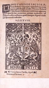
Gaguin (Robert) De Francorum Regum Gestis Scripsit Annales, Paris, Jehan Petit, Pierre Vidoué andForum Auctions4.3(52)See Sold PriceFeb 29, 2024
R. Crumb (American, b. 1943) Robert Johnson, 1988Freeman's | Hindman4.4(1.6k)See Sold PriceMar 07, 2024
Buffon, Vaugody & Bell 1785 America - Map of the New ContinentAlbion Auctions4.6(336)See Sold PriceMar 01, 2024
1826 Memoires De Robert Guillemard Hardcover BookRapid Estate Liquidators and Auction Gallery4.5(1.1k)See Sold PriceFeb 25, 2024
Robert de Vaugondy - Map of Canada - Mer de l' Ouest or Sea of the West and a Northwest PassageProverde Auctions4.3(3)See Sold PriceFeb 28, 2024
Poster "Les jardins de Paris", illustrated map and plan of Paris with its parcs, gardens, monuments,Proverde Auctions4.3(3)See Sold PriceFeb 28, 2024
Robert Neal Hind Engraving Duke Of CambridgeRapid Estate Liquidators and Auction Gallery4.5(1.1k)See Sold PriceFeb 27, 2024


![Robert de Vaugondy, map of Arctic, [ca. 1772]. (1 of 1)](https://p1.liveauctioneers.com/179/17501/5894250_1_x.jpg?height=282&quality=70&version=1225486369)