ATLAS of ANTIENT GEOGRAPHY by SAMUEL BUTLER 1843John McInnis Auctioneers,LLC4.6(502)See Sold PriceFeb 24, 2024
18TH C. ANTIQUE MAP: FRENCH & INDIAN WAR, FRAMEDThomaston Place Auction Galleries4.4(386)See Sold PriceFeb 24, 2024
Rand McNally Railroad Map Cabinet w/ 21 Railroad MapsRail & Road Auctions4.6(165)See Sold PriceMar 08, 2024
Keith Haring - Ink on New York Map, Best Buddies, Inscribed, Signed, and DatedSapphire Auction Gallery4(67)See Sold PriceMar 02, 2024
LATE 17TH C. FRENCH MAP OF THE NEW WORLD BY ALEXIS-HUBERT JAILLOT (1632-1712)Thomaston Place Auction Galleries4.4(386)See Sold PriceFeb 24, 2024
Central Railroad of New Jersey Map of Sandy Hook Route-ca. 1903JM Hobby Supply and Railroad Artifact Auctions4.4(126)See Sold PriceFeb 24, 2024
Lot of Six Mixed Atlas Box Cars-HO Scale-New in BoxJM Hobby Supply and Railroad Artifact Auctions4.4(126)See Sold PriceFeb 25, 2024
Rand McNally/Santa Fe Railroad Map of Iowa-1912JM Hobby Supply and Railroad Artifact Auctions4.4(126)See Sold PriceFeb 24, 2024
NICOLAES VISSCHER (NETHERLANDS, 1618-1709) MAP OF THE NEW WORLDThomaston Place Auction Galleries4.4(386)See Sold PriceFeb 24, 2024
17TH C. WORLD MAP BY NICOLAES VISSCHER (NETHERLANDS, 1618-1709)Thomaston Place Auction Galleries4.4(386)See Sold PriceFeb 24, 2024
Lot of Six Mixed Atlas Cabooses-HO Scale-New in BoxJM Hobby Supply and Railroad Artifact Auctions4.4(126)See Sold PriceFeb 25, 2024
SoldFRAMED RARE 18TH C. MAP OF CORFU BY HOMANNSPlan de la Place de Corfu avec ses Environs Assiegee Par les Infideles, tranchee ouverte le 25me Juillet jusqu'au 22 me d'Aout, Iour de la Fuite des Ottomans". Homann, J. B. Circa 1740. Hand colored cSee Sold Price
SoldRARE 18TH C. MAP OF THE TOWER OF LONDON IN TUDOR TIMES"A True and Exact Draught of the Tower Liberties, survey'd in the year 1597 by Gulielmus Haiward and J. Gascoyne", 1742, hand colored copper engraving, in modern gold panel frame, under French lined mSee Sold Price
Sold18TH C. FRENCH MAP OF THE AMERICAS"Amerique Septentrionale, dressee, sur les Relations plus modernes de Voyageurs et Navigateurs et divisee suivant les differentes possessions des Europens" par la Sr. Robert de Vagoundy, fils de Mr. RSee Sold Price
SoldRARE 18TH C. VARIANT OF DUTCH MAP OF FLORIDA AND"'T Amerikaans Gewest van Florida Door Ferdinand de Soto Nader Ontdekt en groot deels Bemagtigd." Published by Leiden: Pieter van der Aa, 1706, Copper engraving. Uncolored. With an additional line ofSee Sold Price
Sold18TH c. Antique Map of the Americas, CARTE DEL AMERIQUE18TH c. Antique Map of the Americas, CARTE DEL AMERIQUE, approx. 21" x 31" sightSee Sold Price
Sold18TH C. JEAN-BAPTISTE NOLIN, MAP OF THE AMERICASJean-Baptiste Nolin (French, c.1657–1708). "l'Amerique Suivant les Dernier Memoires de J B Nolin Geographe du Roi (Map of North and South America)", hand colored engraving. Elaborately framed. ApSee Sold Price
SoldRARE 18TH C. EXPLORER'S BOOKPernety, Antoine Joseph; "The History of a Voyage to the Malouine (or Falklands) Islands, made in 1763 and 1764, Under the Command of M. de Bougainville, in Order to form a Settlement there: and of TwSee Sold Price
RARE 18TH C. EXPLORER'S BOOKPernety, Antoine Joseph; "The History of a Voyage to the Malouine (or Falklands) Islands, made in 1763 and 1764, Under the Command of M. de Bogainville, in Order to form a Settlement there: and of TwoSee Sold Price
Sold1755 FRENCH MAP OF BRITISH COLONIESSr. Robert de Vaugondy (18th c., France) 18th c map of the British Colonies with inset of the South Carolina Coast. Map by Sr. Robert de Vaugondy. Hand-Colored, on laid paper in two parts. 20.5" h x 2See Sold Price
Sold18th C. English Needlework Maps18th C. English needleworks on silk, globe maps, signed Mary Kekwick and Catherine Kekwick, depicting the Americas and Europe, with a neo-classical floral stitched border, ca 1800, image oval matted 1See Sold Price
Sold(3) NEWBURGH, N.Y. INDENTURE 1729, LOT AND PARCELLOT (2) INCL. RARE NEWBURGH, N.Y. INDENTURE (NEW BURROUGH) 1729, LOT AND PARCEL MAP "THE MINISTER'S LAND" A MAP OF NEWBURGH LOTS LYING IN THE GERMEN PASS, 18TH C., ALSO INCL. IS A HAND COLOR MAP OF THSee Sold Price
Sold5 RARE H/C MANUSCRIPT/ACTUAL SURVEY MAP STOCKPORT NYLOT (5) RARE H/C MANUSCRIPT ACTUAL SURVEY MAP STOCKPORT NY W/ SECTION, BLOCK & LOT NAMED INCL. DELAWARE RIVER; ROAD TO FORT PENN, 18TH C. 19" X 24" W/ MANUSCRIPT LETTER TO SAMUEL PRESTON AUTHORIZING ASee Sold Price
Millar: Antique Map of Hanover, 1768Title/Content of Map: 1768 Millar Map of Hanover -- A New Correct Plan of Hanover Date Printed: 1768 c. Cartographer: G Millar Size: 14.3 x 9.3 in. A very interesting and rather rare 18th century planSee Sold Price
Woods: Antique View of Flying Bridge, China, 18th CMap: Rare Antique 18th-century engraving of a view of the Flying Bridge over the River Whang-Ho in China Size: Measuring approx 9 x 13 inches Maker: J. Woods Material: Ink of paper Size: 9x13 Date: 18See Sold Price
Korea, 18th c. - Shihei Hayashi (1738-1793)Ancient history book of Korea dating from 1768 containing geographical and political information, including maps of the ancient territories. Rare map of the Dokdo Islands drawn by the Japanese geograpSee Sold Price
SoldMap by M. Bonne, "Carte de la Partie Sud Des EtatsMap, "Carte de la Partie Sud Des Etats Unis De L'Amerique Septentrionale", by M. Bonne, Paris, c. 1780,a rare colored map of the southeastern US printed during the Revolutionary War by America's FrencSee Sold Price
SoldRare Michael Mercator Map of the AmericasAmerica sive India Nova...Michael Mercator (c. 1567-1600). Engraved map with original hand color. Duisburg, 1595 (but Hondius: Amsterdam, 1613 or later). 15 x 18 1/2 inches visible, 26 x 29 inches fraSee Sold Price
Chereau: Antique Map, City View of Florence, 1750Title: Florence. Florence Ville d'Italie, capitale de Toscane. . .Extremely rare and lovely mid-18th century town-view of Florence Map maker: Jacques Chereau, P. A. Aveline Place and Year: Paris, c. 1See Sold Price
SoldRARE 18TH C. TEN-THOUSANDS PEARLS DRAGON SILK ROBEIMPORTANT, RARE, 18th C. QING DYNASTY, Qianlong REIGN PERIOD (AD 1736-1796), THE TEN-THOUSANDS PEARLS EMBROIDERY SILK IMPERIAL DRAGON ROBE PROVENANCE: From the private collections of Madame Kimball, oSee Sold Price
SoldRare 18th C. Barbary Coast Pirate BlunderbussAttention all Pirates! Here we have the Real Deal and it is Cooler That it appears in Pictures! This is an Authentic Rare 18th Centure Barbary Coast Pirate Flintlock Blunderbuss, In Excellent ConditioSee Sold Price
SoldRARE 18TH C. PHOENIX SILK ROBE18th C. QING DYNASTY EMBROIDERY IMPERIAL PHOENIX SILK ROBEThe robe wealthy decorated with dragon motifs, cleverly simulating the phoenix borne from turbulent cresting waves, all delicately embroideredSee Sold Price
SoldA Rare 18th C. Swedish Gilt And Polychromeclock, with eagle mount, 30 h x 17 w, from a Lakewood Blvd Dallas EstateSee Sold Price
SoldRARE 18TH C. LARGE CHINESE SINO-TIBETAN THANGKAIMPORTANT, RARE 18th C. Large Chinese Sino-Tibetan embroidery silk Thangka, finely embroidery illustrated the scene of "The 8 forms of Padmasambhava", the Main Founder of Tibetan Buddhism together witSee Sold Price
SoldExceptional Rare 18th C. Carved Court SceneWith Detailed Carvings Of Opera Or Tournament Attendees On Balcony. Water Gilt Finish. Typical Loss To Gilding Commensurate With Age, See Photos Of Figures That Have Been Reinforced And Touched Up AtSee Sold Price
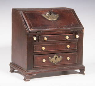
RARE MINIATURE QUEEN ANNE SLANT FRONT DESKThomaston Place Auction Galleries4.4(386)See Sold PriceFeb 24, 2024
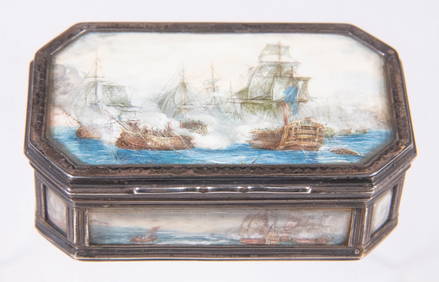
RARE SILVER MOUNTED SNUFF BOX WITH SHIP PAINTINGSThomaston Place Auction Galleries4.4(386)See Sold PriceFeb 24, 2024
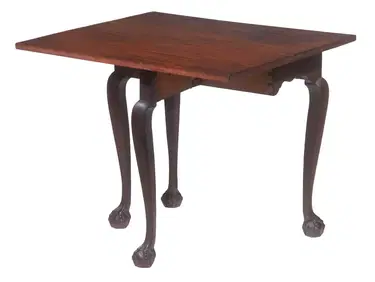
RARE DIMINUTIVE CHIPPENDALE SINGLE DROP-LEAF TABLEThomaston Place Auction Galleries4.4(386)See Sold PriceFeb 24, 2024
LATE 18TH C. VERY LARGE CHART OF NORTHEAST CANADA BY DES BARRES (1721-1824), 1780, FRAMEDThomaston Place Auction Galleries4.4(386)See Sold PriceFeb 24, 2024
EARLY 18TH C. MAP OF ITALY, FRAMEDThomaston Place Auction Galleries4.4(386)See Sold PriceFeb 24, 2024
18TH C. ANTIQUE MAP: FRENCH & INDIAN WAR, FRAMEDThomaston Place Auction Galleries4.4(386)See Sold PriceFeb 24, 2024
18th C. QUEEN ANNE CHINOISERIE DRESSING MIRRORLewis & Maese Antiques & Auction4.4(520)See Sold PriceFeb 25, 2024
Two (2) Antique 18th C. Copper Engraved Framed Maps - America & EuropeMagnusson Art Group4.5(46)See Sold PriceMar 14, 2024
Map: An 18thC engraved and hand coloured map of Buckinghamshire after Robert Morden. Approx. 8 1/4"Claydon Auctioneers Ltd4.3(125)See Sold PriceFeb 26, 2024
Map: An 18thC engraved and hand coloured map of Northamptonshire, with description ofClaydon Auctioneers Ltd4.3(125)See Sold PriceFeb 26, 2024
Map: An 18thC engraved and hand coloured map of North America and South America, titled DeClaydon Auctioneers Ltd4.3(125)See Sold PriceFeb 26, 2024
Map: An 18thC engraved map of Bedfordshire titled An Accurate Map of the County of Bedford DividedClaydon Auctioneers Ltd4.3(125)See Sold PriceFeb 26, 2024
Map: An 18thC engraved map titled A New and Improved Map of Oxfordshire.. after Thomas Kitchin.Claydon Auctioneers Ltd4.3(125)See Sold PriceFeb 26, 2024
ANTIQUE ROMAN ARMORIAL VELLUM BINDING, 1744, ILLUSTRATED WITH AN ANTIQUE MAP BY FLORUSNY Elizabeth 4.3(84)See Sold PriceMar 03, 2024
THE WHOLE CHRONICLE OF POLYBIUS ANCIENT IN ENGLISH, 1756NY Elizabeth 4.3(84)See Sold PriceMar 03, 2024
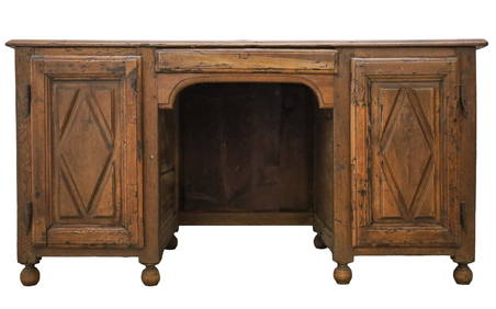
18TH C. QUEEN ANNE CHEST ON CHEST, PORTSMOUTH, NH.William Smith Auctions4.6(146)See Sold PriceMar 06, 2024