Rare 1877 chart of the Bermuda islands.Seldom found chart of the Bermuda islands from the Hydrographic office of the US Navy. With enlarged area of the narrows or ship channel in St. George harbor. Another enlarged area showing grassy baySee Sold Price
Sold1877 chart showing Amelia Island, FloridaAmelia Island, Florida chart. US Coast Survey chart dated 1877 showing the east coast of Florida from the Amelia Island to Halifax River. Matted and framed. 40" high x 22" wide.See Sold Price
SoldELDRIDGES LONG ISLAND SOUND CHART NEW YORK TO NEWRare Eldridge chart of Long Island Sound from New York to New London dated 1922. Showing all local ports along the Connecticut and north shore Long Island shorelines.See Sold Price
SoldCaribbean.- Bermuda.- Greirson (George) [Island ofCaribbean.- Bermuda.- Greirson (George) [Island of Bermuda], chart from an Irish-printed pirated version of Mount & Page's 'English Pilot', engraving without watermark, platemark 300 x 230 mm. (11 3/4See Sold Price
SoldRare chart of Chiniatski Bay in Kadiak Island AlaskaHeading: Author: Sarychev, Gavrill Andreyevitch Title: [in Russian] Chart of Chiniatski Bay, situated in the Island of Kadiak, with the entrance to Paul Harbor and the settlement of the Russian AmeriSee Sold Price
Bermuda Islands, North Atlantic Ocean. ADMIRALTY sea chart 1946 (1950) old mapTitle: Bermuda Islands, North Atlantic Ocean. ADMIRALTY sea chart 1946 (1950) old map Description: North Atlantic Ocean - Bermuda Islands' by From Admiralty surveys to 1937 and United States GovernmenSee Sold Price
Bermuda Great Sound. Hamilton Harbour ADMIRALTY sea chart 1941 (1956) old mapTitle: Bermuda Great Sound. Hamilton Harbour ADMIRALTY sea chart 1941 (1956) old map Description: North Atlantic Ocean - Bermuda Islands - Great Sound including Hamilton Harbour' by Surveyed by CaptaiSee Sold Price
Sold1877 Chart of MaineOriginal chart of Penobscot Bay to Kennebec Entrance from 1877 by US Coastal Survey - Details include Westport Island, Southport Island, Georgetown Island, Bath, Waldoboro, Thomaston etc... Also showsSee Sold Price
SoldChart of Vineyard Sound and Nantucket Shoals.Fine recreation of the 1877 Eldridge chart showing Martha's Vineyard, Nantucket, the Elizabeth Islands and the Cape Cod coast from Falmouth to Chatham. Nicely framed. 38" high x 56" wide.See Sold Price
SoldOriginal Imray & Son S. America Coast Chart, 1877Nautical Chart of South American coast, between Rio de la Plata and Valparaiso. Details include Cape Horn Islands, South Shetlands, Falklands, Southern tip of South American coast including Chile andSee Sold Price
Rare British chart of North Coast of Brazil 1813Title: Chart of the North Coast of Brazil, from St. John's Island to the Rifer Preguicas; by Lieut. George Crichton, R.N. 1813 Author: British Admiralty Description: Engraved chart. Engraved by J. WalSee Sold Price
World Coins from Various PropertiesBermuda, Ireland Island Co-operative Society Ltd, uniface brass Fivepence, 29mm (Lyall 108). Fair with heavy surface corrosion, rare £80-£100 ------ For more information, additional imagesSee Sold Price
World Coins from Various PropertiesBermuda, Ireland Island Co-operative Society Ltd, uniface brass Penny, 29mm (Lyall –; cf. Roehrs 1068). About fine, rare £200-£300 ------ For more information, additional images andSee Sold Price
World Coins from Various PropertiesBermuda, Ireland Island Co-operative Society Ltd, uniface brass Elevenpence, 29mm (Lyall 105). Very fine, rare £200-£300 ------ For more information, additional images and to bid on this lSee Sold Price
World Tokens, the Property of a North Country CollectorBermuda, IRELAND ISLAND, Ireland Island Co-Operative Society Ltd., uniface, 8 Pence, legend around 8d, brass, 29mm (Lyall 106). Very fine, very rare £150-£200 --- Provenance: Bt. J. SchimmSee Sold Price
World Tokens, the Property of a North Country CollectorBermuda, IRELAND ISLAND, Ireland Island Co-Operative Society Ltd., uniface, 11 Pence, legend around 11d, brass, 29mm (Lyall 105). Very fine, some spots of staining, very rare £200-£300 ---See Sold Price
World Tokens, the Property of a North Country CollectorBermuda, IRELAND ISLAND, Ireland Island Co-Operative Society Ltd., uniface, 1 Penny, legend around 1d, brass, 29mm (cf. Lyall 105-109). Extremely fine, with original colour, very rare £150-&pounSee Sold Price
World Tokens, the Property of a North Country CollectorBermuda, IRELAND ISLAND, Ireland Island Co-Operative Society Ltd., uniface, 3 Pence, legend around 3d, brass, 29mm (Lyall 109). Nearly very fine, very rare £150-£200 --- Provenance: Bt. LaSee Sold Price
World Tokens, the Property of a North Country CollectorBermuda, IRELAND ISLAND, Ireland Island Co-Operative Society Ltd., uniface, 5 Pence, legend around 5d, brass, 29mm (Lyall 108). Nearly fine, with some staining and corrosion, very rare £150-&pouSee Sold Price
World Tokens, the Property of a North Country CollectorBermuda, IRELAND ISLAND, Ireland Island Co-Operative Society Ltd., uniface, 7 Pence, legend around 7d, brass, 29mm (Lyall 107). Good very fine, very rare £200-£300 --- Provenance: Bt. LarrSee Sold Price
Cuba, the Bahamas & Bermuda "or Summer Islands".TITLE/CONTENT OF MAP: 'Chart of the Bahama Islands. The Bermudas or Summer Islands. Island of Cuba' DATE: 1817 IMAGE SIZE: Approx 53.5 x 63.5cm, 21 x 25 inches (Large); Please note that this is a foldSee Sold Price
Cuba, the Bahamas & Bermuda "or Summer Islands".Reserve Reduced! TITLE/CONTENT OF MAP: 'Chart of the Bahama Islands. The Bermudas or Summer Islands. Island of Cuba' DATE: 1817 IMAGE SIZE: Approx 53.5 x 63.5cm, 21 x 25 inches (Large); Please note thSee Sold Price
Cuba, the Bahamas & Bermuda "or Summer Islands". THOMSON 1817 old antique mapTITLE/CONTENT OF MAP: 'Chart of the Bahama Islands. The Bermudas or Summer Islands. Island of Cuba' DATE PRINTED: Published in 1817. Engraved in 1816; this date is marked on the map IMAGE SIZE: ApproxSee Sold Price
Cuba, the Bahamas & Bermuda "or Summer Islands".TITLE/CONTENT OF MAP: 'Chart of the Bahama Islands. The Bermudas or Summer Islands. Island of Cuba' DATE PRINTED: 1817 IMAGE SIZE: Approx 53.5 x 63.5cm, 21 x 25 inches (Large); Please note that this iSee Sold Price
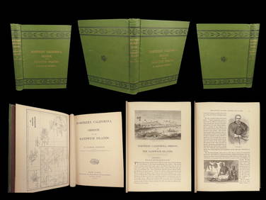
1874 HAWAII 1ed Northern California Oregon Pacific Island Travel Puget RedwoodsSchilb Antiquarian Rare Books4.8(422)See Sold PriceMar 10, 2024
LATE 18TH C. VERY LARGE CHART OF NORTHEAST CANADA BY DES BARRES (1721-1824), 1780, FRAMEDThomaston Place Auction Galleries4.4(389)See Sold PriceFeb 24, 2024
RARE 1638 HONDIUS MAP OF BERMUDA, FRAMEDThomaston Place Auction Galleries4.4(389)See Sold PriceFeb 24, 2024
CHART "LONG ISLAND SOUND FROM NEW YORK TO MONTOCK POINT ..." New York, 1830 21" x 77" sight. FramedEldred's4.7(418)See Sold PriceFeb 27, 2024
CHART "SOUTHERN COAST OF LONG ISLAND FROM MONTAUK POINT TO EAST HAMPTON" Circa 1877 11.25" x 22.75"Eldred's4.7(418)See Sold PriceFeb 27, 2024
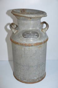
Rock Island RR Milk CanJM Hobby Supply and Railroad Artifact Auctions4.4(126)See Sold PriceFeb 24, 2024
Rare! Antique Victorian Consolidated Glass Coreopsis Milk Glass Oil LampWestside Traders Emporium4.5(34)See Sold PriceFeb 27, 2024
1764 Bellin Map of Lesser Antilles Northern Portion -- Petites Antilles ou Isles du Vent 3e. Partie.Jasper524.5(9.8k)See Sold PriceFeb 27, 2024
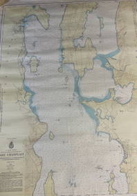
CHART: U.S LAKE SURVEYS/ LAKE CHAMPLAIN/ CUMBERLAND HEAD, NY and SAVAGE ISLAND, VT. TO FOUR BROTHERSChurchill Galleries3.7(216)See Sold PriceFeb 26, 2024