SoldRare chart of Chiniatski Bay in Kadiak Island AlaskaHeading: Author: Sarychev, Gavrill Andreyevitch Title: [in Russian] Chart of Chiniatski Bay, situated in the Island of Kadiak, with the entrance to Paul Harbor and the settlement of the Russian AmeriSee Sold Price
Nautical Map / Sea Chart, #224 Oyster & Huntington BaysDescription: Nautical Map / Sea Chart, Oyster & Huntington Bays South Shore of Long Island Sound,3rd edition Feb1 / 43, Revised 11/30/59 ; Shipping: $20; different rate to California, Alaska, Hawaii &See Sold Price
SoldELDRIDGES CHART CAPE COD TO BELLE ISLANDRare George Eldridge chart from 1914 shwinfg the waters from CAPE COD toBELLE ISLE. including the Bay of Fundy, Gulf of St. Lawrence and the Banks of Newfoundlland. Published by SmThaxter and Son of BSee Sold Price
Nautical Map / Sea Chart, #224 Oyster & Huntington BaysDescription: Nautical Map / Sea Chart, United States East Coast, New York Long Island, Oyster & Huntington Bays, 8th edition Dec 2/68; Folded; Shipping: $20; different rate to California, Alaska, HawaSee Sold Price
Nautical Map / Sea Chart, #224 Oyster & Huntington BaysDescription: Nautical Map / Sea Chart, United States East Coast, New York Long Island, Oyster & Huntington Bays, 8th edition Dec 2/68; Folded; Shipping: $20; different rate to California, Alaska, HawaSee Sold Price
Nautical Map / Sea Chart, #224 Oyster & Huntington BaysDescription: Nautical Map / Sea Chart, United States East Coast, New York Long Island, Oyster & Huntington Bays, 8th edition Dec 2/68; Folded; Shipping: $20; different rate to California, Alaska, HawaSee Sold Price
Nautical Map / Sea Chart, #224 Oyster & Huntington BaysDescription: Nautical Map / Sea Chart, United States East Coast, New York Long Island, Oyster & Huntington Bays, 8th edition Dec 2/68; Folded; Shipping: $20; different rate to California, Alaska, HawaSee Sold Price
Nautical Map / Sea Chart, #224 Oyster & Huntington BaysDescription: Nautical Map / Sea Chart, United States East Coast, New York Long Island, Oyster & Huntington Bays, 8th edition Dec 2/68; Folded; Shipping: $20; different rate to California, Alaska, HawaSee Sold Price
Nautical Map / Sea Chart, #224 Oyster & Huntington BaysDescription: Nautical Map / Sea Chart, United States East Coast, New York Long Island, Oyster & Huntington Bays, 8th edition Dec 2/68; Folded; Shipping: $20; different rate to California, Alaska, HawaSee Sold Price
Nautical Map / Sea Chart, #224 Oyster & Huntington BaysDescription: Nautical Map / Sea Chart, United States East Coast, New York Long Island, Oyster & Huntington Bays, 8th edition Dec 2/68; Folded; Shipping: $20; different rate to California, Alaska, HawaSee Sold Price
Nautical Map / Sea Chart, #224 Oyster & Huntington BaysDescription: Nautical Map / Sea Chart, United States East Coast, New York Long Island, Oyster & Huntington Bays, 8th edition Dec 2/68; Folded; Shipping: $20; different rate to California, Alaska, HawaSee Sold Price
SoldRare Russian map of Kodiak Island 1849Heading: Author: Russia, Russian American Company Title: [in Russian] Mercator's Chart of Kodiak Archipelago compiled by the Russian American Company... 1849. [with ten inset maps of bays and ports]See Sold Price
Antique Chart - Elizabeth Bay - Island Bay - America - St. Davids Bay - ChileTitle: Antique Chart - Elizabeth Bay - Island Bay - America - St. Davids Bay - Chile Description: This captivating engraving map by Captain James Cook originates from "An Account of the Voyages UndertSee Sold Price
SoldHEINIE HARTWIG (California, born 1936) Oil on masonHEINIE HARTWIG (California, born 1936) Oil on masonite "Loring Bay, Revillagigedo Island" (Alaska) Mountain landscape with village 6 in. by 12 in. Signed Heinie Hartwig l.l. Well framed.See Sold Price
SoldSpanish chart of Yakutat Bay Alaska 1791-1802Title: Plano del Puerto del Desengaño Trabajado de Orden del Rey en 1791. Observato. Latitud N. 59o.51'.10". Longitud 133o.30'.28". Ocidentl. de Cadiz... Author: Galiano, Dionisio Alcalá & CayetanoSee Sold Price
SoldY Sonnichsen "Saginaw Bay" OilYNGVAR SONNICHSEN (American 1873-1938) "Saginaw Bay Kuiu Island, SE Alaska" Oil on canvas. 20.25 x 32 inches/ 51.5 x 81.3 centimeters. Signed lower left "Y. Sonnichsen" Verso: Titled, signed and datedSee Sold Price
SoldY Sonnichsen "Saginaw Bay" OilYNGVAR SONNICHSEN (American 1873-1938) Saginaw Bay Kuiu Island, SE Alaska Oil on canvas 20.25 x 32 inches Signed lower left "Y. Sonnichsen" Verso: Titled, signed and dated in oil pastel "Saginaw Bay KSee Sold Price
MAP, Cartagena, Colombia, JefferysCartagena, Colombia. Thomas Jefferys, Plan of the Harbour of Carthagena, 1762 (published). Hand Color. This rare chart shows Cartagena Bay oriented with north to the left. There is good detail of theSee Sold Price
SoldNorie (J.W.) The Gulf of PersiaNorie (J.W.) The Gulf of Persia,coastal chart with rhum lines, coastal recognition views, and 5 inset charts of bays and islands, including Muscat and the mouth of the Euphrates, engraved charSee Sold Price
SoldBeechey's rare chart of San Francisco Bay 1833Heading: Author: Beechey, Frederick William Title: The Harbour of San Francisco, Nueva California [on sheet with] The Entrance of San Francisco Harbour [and selection of coastal profiles and views] PSee Sold Price
Rare Captain's Charts of Chesapeake BayBache, Alexander D. (1806-1867). Coast Chart No. 34 Chesapeake Bay from Choptank River to Potomac River... 1863. Lithographed map. U.S. Coast and Geodetic Survey, 1885. 29 ¼" x 37 ½" sheet. ScarSee Sold Price
Antique British Sea Chart of Mobile Bay Dauphin IslandTitle/Content of Map: Antique British sea chart of Mobile Bay and Dauphin Island Date Printed: 1872 Cartographer: British Admiralty Hydrographical Office Size (inches): 26 x 36 Condition: Good. RolledSee Sold Price
SoldELDRIDGES LONG ISLAND SOUND CHART NEW YORK TO NEWRare Eldridge chart of Long Island Sound from New York to New London dated 1922. Showing all local ports along the Connecticut and north shore Long Island shorelines.See Sold Price
(AUSTRALIA.) British Hydrographic Office. Australia -(AUSTRALIA.) British Hydrographic Office. Australia - East Coast Queensland / Moreton Bay. Engraved nautical chart of Moreton Bay, Moreton Island, and the mouth of the Brisbane River on two large unjoSee Sold Price
LATE 18TH C. VERY LARGE CHART OF NORTHEAST CANADA BY DES BARRES (1721-1824), 1780, FRAMEDThomaston Place Auction Galleries4.4(389)See Sold PriceFeb 24, 2024
CHART "LONG ISLAND SOUND FROM NEW YORK TO MONTOCK POINT ..." New York, 1830 21" x 77" sight. FramedEldred's4.7(418)See Sold PriceFeb 27, 2024
Doug Hudson Rare Hand Carved Sculptured Wood Mural "Puffin" 1985Dana J. Tharp Auctions4.7(268)See Sold PriceFeb 24, 2024
Christo Signed Postcard Surrounded Islands Biscayne BayHeritage Gallery Auctions4.4(56)See Sold PriceMar 10, 2024
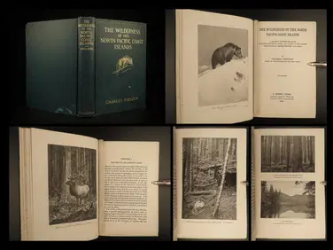
1912 HUNTING Alaska Vancouver Sheldon Wilderness of North Pacific Canada BearSchilb Antiquarian Rare Books4.8(422)See Sold PriceMar 31, 2024
Christo - Surrounded Islands Project for Biscayne Bay Miami Florida`Dane Fine Art Auctions4.4(496)See Sold PriceMar 21, 2024
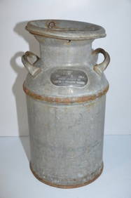
Rock Island RR Milk CanJM Hobby Supply and Railroad Artifact Auctions4.4(126)See Sold PriceFeb 24, 2024
Alcatraz Prison Original Scrapbook with 58 Photo's from 1974Jasper524.5(9.8k)See Sold PriceFeb 27, 2024
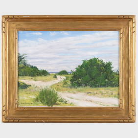
Simon Parkes (b. 1954): From Three Mile Harbor Towards Gardiner's Bay, Long IslandSTAIR4.6(288)See Sold PriceMar 07, 2024