ATLAS of ANTIENT GEOGRAPHY by SAMUEL BUTLER 1843John McInnis Auctioneers,LLC4.5(505)See Sold PriceFeb 24, 2024
18TH C. ANTIQUE MAP: FRENCH & INDIAN WAR, FRAMEDThomaston Place Auction Galleries4.4(393)See Sold PriceFeb 24, 2024
Rand McNally Railroad Map Cabinet w/ 21 Railroad MapsRail & Road Auctions4.6(165)See Sold PriceMar 08, 2024
Keith Haring - Ink on New York Map, Best Buddies, Inscribed, Signed, and DatedSapphire Auction Gallery4(67)See Sold PriceMar 02, 2024
LATE 17TH C. FRENCH MAP OF THE NEW WORLD BY ALEXIS-HUBERT JAILLOT (1632-1712)Thomaston Place Auction Galleries4.4(393)See Sold PriceFeb 24, 2024
Central Railroad of New Jersey Map of Sandy Hook Route-ca. 1903JM Hobby Supply and Railroad Artifact Auctions4.4(127)See Sold PriceFeb 24, 2024
Lot of Six Mixed Atlas Box Cars-HO Scale-New in BoxJM Hobby Supply and Railroad Artifact Auctions4.4(127)See Sold PriceFeb 25, 2024
Rand McNally/Santa Fe Railroad Map of Iowa-1912JM Hobby Supply and Railroad Artifact Auctions4.4(127)See Sold PriceFeb 24, 2024
NICOLAES VISSCHER (NETHERLANDS, 1618-1709) MAP OF THE NEW WORLDThomaston Place Auction Galleries4.4(393)See Sold PriceFeb 24, 2024
17TH C. WORLD MAP BY NICOLAES VISSCHER (NETHERLANDS, 1618-1709)Thomaston Place Auction Galleries4.4(393)See Sold PriceFeb 24, 2024
Lot of Six Mixed Atlas Cabooses-HO Scale-New in BoxJM Hobby Supply and Railroad Artifact Auctions4.4(127)See Sold PriceFeb 25, 2024
SoldRapkin, John 1860 Map. World on Mercator's ProjectionSteel Engraved Map Published 1860 by The London Printing & Published Company, London for "The Royal Dictionary-Cyclopedia for Universal Reference" by Thomas Wright. Drawn & Engraved by John Rapkin. FoSee Sold Price
SoldRapkin, John 1860 Map. World on Mercator's ProjectionSteel Engraved Map Published 1860 by The London Printing & Published Company, London for "The Royal Dictionary-Cyclopedia for Universal Reference" by Thomas Wright. Drawn & Engraved by John Rapkin. FoSee Sold Price
SoldMap World of Mercator's Projection John TallesMap World of Mercator's Projection John Talles - drawn & engraved by J. RapkinSee Sold Price
SoldRapkin, John 1860 Map. World HemispheresSteel Engraved Map Published 1860 by The London Printing & Published Company, London for "The Royal Dictionary-Cyclopedia for Universal Reference" by Thomas Wright. Drawn & Engraved by John Rapkin. FoSee Sold Price
SoldRapkin, John 1860 Map of the World HemispheresSteel Engraved Map Published 1860 by The London Printing & Published Company, London for "The Royal Dictionary-Cyclopedia for Universal Reference" by Thomas Wright. Drawn & Engraved by John Rapkin. FoSee Sold Price
SoldSix maps by AJ Johnson 1850sTitle: Johnson's maps - six maps Author: Johnson, A.J. Description: Includes: Delaware and Maryland. 1-page map. N.d. [c.1860]. * World on Mercators Projection. 2-page map. 1865. * California, Also UtSee Sold Price
SoldGuthrie, William 1798 Map World of Mercators ProjectionCopper Engraved Map Published 1798, London for "A New Geographical, Historical and Commercial Grammar..." by William Guthrie. The maps are by John Senex, Thomas Kitchin and others. Folds as issued. PaSee Sold Price
World on Mercator's Projection.Reserve Reduced! Title/Content of Map: World on Mercator's Projection. Date: 1822 Cartographer: John Purdy Material/Medium: R.H. Laurie Size: 11.75Height - 18.6Width Published by R.H. Laurie No. 53 FlSee Sold Price
The World: Shewing the Voyages of Captain Cook 1849 MapThe World. 'Shewing the Voyages of Captain Cook'. Tallis/rapkin 1849 Old Map. Title/content of Map: 'the World on Mercator's Projection Shewing the Voyages of Captain Cook Around the World' the Track'See Sold Price
Nice 1860 world map by MitchellMap of the World on the Mercator Projection Exhibiting the American Continent as its Centre. 1860 date; from MitchellÂ’s 1862 atlas. Top left margin trimmed, apparently as printed. Toning at edges.See Sold Price
The World on Mercator's Projection. SWANSTON 1860 oldTITLE/CONTENT OF MAP: 'The World on Mercator's Projection' The top image on the right hand side shows the entire map. To view a close up of the map showing the level of printed detail, please click onSee Sold Price
The World on Mercator's Projection by John Dower 1845 old antique map chartTITLE/CONTENT OF MAP: 'The World on Mercator's Projection' DATE PRINTED: 1845 IMAGE SIZE: Approx 22.0 x 27.5cm, 8.75 x 10.75 inches (Medium) TYPE: Antique map with original hand colouring CONDITION: FSee Sold Price
World on Mercator's Projection by John Dower. British Empire in pink 1876 mapTITLE/CONTENT OF MAP: 'The World on Mercator's Projection By John Dower F.R.G.S. N.B. British Possessions are colored red' DATE PRINTED: 1876 IMAGE SIZE: Approx 34.5 x 52.0cm, 13.5 x 20.5 inches (LargSee Sold Price
The World on Mercator's Projection. SWANSTON 1860 old antique map plan chartTITLE/CONTENT OF MAP: 'The World on Mercator's Projection' DATE PRINTED: 1860 IMAGE SIZE: Approx 44.0 x 53.5cm, 17.25 x 21 inches (Large); Please note that this is a folding map. TYPE: Antique atlas mSee Sold Price
Sold[Map] The World on Mercator's Projection Shewing the[Map] Tallis, J. and J. Rapkin. The World on Mercators Projection Shewing the Voyages of Captain Cook Round the World. [London, 1851]. Hand colored with a decorative border and vignettes showing the 3See Sold Price
Pinkerton: The World on Mercators Projection, 1818Map: The World on Mercators Projection, 2 sheets Maker: John Pinkerton Date: c. 1818 Medium: Copperplate engraving Description: Two large double folio sheets comprising a world map on Mercator's ProjeSee Sold Price
SoldTallis: Map of The World on Mercator's Projection, 1853The World on Mercator's Projection. Original lithograph by John Tallis & Company of London, c. 1853. Map vignettes feature Vesuvius, London, Gibraltar, Constantinople, the Pyramids of 'Ghizeh' (Giza),See Sold Price
SoldWalker, John 1795 Map of the World on Mercators Proj."General Chart on Mercators Projection" Copper Engraved Map Published 1795, London for "Elements of Geography, and of Natural and Civil History" by John Walker. Centre fold as published. Paper Size: 1See Sold Price
Sold[TALLIS, JOHN] A lot of 9 maps by John Tallis & Co[TALLIS, JOHN] A lot of 9 maps by John Tallis & Co. London / New York, ca. 1840. Approx. 20 x 30 each. Includes:Eastern Hemisphere ** Central America ** The World on Mercators Projection Shewing The VSee Sold Price
SoldUntitled. [the World On Mercator's Projection]Title/Content of Map: Untitled. [the World On Mercator's Projection] Date Printed: 1920 ca. Cartographer: BARTHOLOMEW, JOHN & SON Size: 49.75x73 Full color gauze back dissected folding map. Folds intoSee Sold Price
SoldA Geographical Description of the World[..Intended as an Accompaniment to the Map of the World on Mercator's Projection], by John Melish, (Scottish, 1771-1822), Philadelphia: published John Melish, 1818, with three folding maps (complete),See Sold Price
SoldEnsign Map of the WorldT. & E.H. Ensign: "Map of The World, On Mercators Projection", Hand colored copper plate engraving, published by T. & E.H. Ensign, New York: 1844. Geographical Part Engraved by John M. Atwood. PhelpsSee Sold Price
SoldJohnsonJohnson's 'Map of the World On Mercators Projection,' circa 1860's. Alvin Jewett Johnson Cartographer. Stamped 'Entered according to Act of Congress in the Year 1865 by A. J. Johnson in the Clerks OffSee Sold Price
Chart of the World On Mercator's Projection,Map: Chart of the World On Mercator's Projection, Publication Date: 1845 Cartographer: JOHNSTON, A. K. Publisher: JOHN JOHNSTONE AND W. & A.K. JOHNSTON Size (inches): 19.6X23.3 "by A.K. Johnson..." PlSee Sold Price
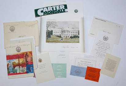
1977 INAUGURATION of PRESIDENT JIMMY CARTERJohn McInnis Auctioneers,LLC4.5(505)See Sold PriceFeb 25, 2024
Arrowsmith & Lewis - Map of the World on Mercator's ProjectionTrillium Antique Prints & Rare Books4.5(32)See Sold PriceFeb 24, 2024
Carey, pub. 1796 - A Chart of the West IndiesTrillium Antique Prints & Rare Books4.5(32)See Sold PriceFeb 24, 2024
Carey, pub. 1796 - Map of the State of MarylandTrillium Antique Prints & Rare Books4.5(32)See Sold PriceFeb 24, 2024
Carey, pub. 1796 - Map of GeorgiaTrillium Antique Prints & Rare Books4.5(32)See Sold PriceFeb 24, 2024
Carey, pub. 1796 - Map of The State of South CarolinaTrillium Antique Prints & Rare Books4.5(32)See Sold PriceFeb 24, 2024
Carey, pub. 1796 - Map of KentuckyTrillium Antique Prints & Rare Books4.5(32)See Sold PriceFeb 24, 2024
Carey, pub. 1796 - Map of the Tennassee State formerly part of North Carolina (Tennessee)Trillium Antique Prints & Rare Books4.5(32)See Sold PriceFeb 24, 2024
De Jode, Rare, pub. 1593 - Map of Africa (Africae Vera Forma, et Situs)Trillium Antique Prints & Rare Books4.5(32)See Sold PriceFeb 24, 2024
NORTHERN AFRICA. Morocco Tunisia Algeria. Caravan routes. RAPKIN/TALLIS 1851 mapJasper524.5(9.9k)See Sold PriceFeb 28, 2024
NORTHERN AFRICA. Morocco Tunisia Algeria. Caravan routes.TALLIS/RAPKIN 1851 mapJasper524.5(9.9k)See Sold PriceFeb 28, 2024
NORTHERN AFRICA. Morocco Tunisia Algeria. Caravan routes. RAPKIN/TALLIS 1851 mapJasper524.5(9.9k)See Sold PriceFeb 28, 2024
Blackie (Pub) 1882 Folio Map. World on Mercators ProjectionAlbion Auctions4.6(341)See Sold PriceMar 01, 2024


![[Map] The World on Mercator's Projection Shewing the (1 of 1)](https://p1.liveauctioneers.com/928/150426/75971118_1_x.jpg?height=282&quality=70&version=1568819120)


![[TALLIS, JOHN] A lot of 9 maps by John Tallis & Co (1 of 1)](https://p1.liveauctioneers.com/1124/187577/94368895_1_x.jpg?height=282&quality=70&version=1607095126)
![Untitled. [the World On Mercator's Projection] (1 of 2)](https://p1.liveauctioneers.com/5584/120869/61529702_1_x.jpg?height=282&quality=70&version=1524613752)