ATLAS of ANTIENT GEOGRAPHY by SAMUEL BUTLER 1843John McInnis Auctioneers,LLC4.5(505)See Sold PriceFeb 24, 2024
18TH C. ANTIQUE MAP: FRENCH & INDIAN WAR, FRAMEDThomaston Place Auction Galleries4.4(394)See Sold PriceFeb 24, 2024
Rand McNally Railroad Map Cabinet w/ 21 Railroad MapsRail & Road Auctions4.6(165)See Sold PriceMar 08, 2024
Keith Haring - Ink on New York Map, Best Buddies, Inscribed, Signed, and DatedSapphire Auction Gallery4.1(67)See Sold PriceMar 02, 2024
LATE 17TH C. FRENCH MAP OF THE NEW WORLD BY ALEXIS-HUBERT JAILLOT (1632-1712)Thomaston Place Auction Galleries4.4(394)See Sold PriceFeb 24, 2024
Central Railroad of New Jersey Map of Sandy Hook Route-ca. 1903JM Hobby Supply and Railroad Artifact Auctions4.4(127)See Sold PriceFeb 24, 2024
Lot of Six Mixed Atlas Box Cars-HO Scale-New in BoxJM Hobby Supply and Railroad Artifact Auctions4.4(127)See Sold PriceFeb 25, 2024
Rand McNally/Santa Fe Railroad Map of Iowa-1912JM Hobby Supply and Railroad Artifact Auctions4.4(127)See Sold PriceFeb 24, 2024
NICOLAES VISSCHER (NETHERLANDS, 1618-1709) MAP OF THE NEW WORLDThomaston Place Auction Galleries4.4(394)See Sold PriceFeb 24, 2024
17TH C. WORLD MAP BY NICOLAES VISSCHER (NETHERLANDS, 1618-1709)Thomaston Place Auction Galleries4.4(394)See Sold PriceFeb 24, 2024
Lot of Six Mixed Atlas Cabooses-HO Scale-New in BoxJM Hobby Supply and Railroad Artifact Auctions4.4(127)See Sold PriceFeb 25, 2024
SoldRAND McNALLEY MAP OF US AND WORLD ON REVERSESHOWING A RAND McNALLY & SONS MAP OF THE UNITED STATES . SET IN A FITTED OAK CASE . CIRCA 1900 .ON THE REVERSE IS A NEW INDEXED MAP OF THE WORLD . SELLING AS IS CONDITION. MEASURES 64" WIDE . THE ABSESee Sold Price
SoldFolding Rarilroad map of U.S. c.1880Title: Map of the Atchison, Topeka and Santa Fe Railroad and its Leased Lines Author: Rand, McNalley Description: Folding lithographed map. 61x94 cm. (24x37").Railroads of whole U.S., with emphasis ofSee Sold Price
SoldRand McNally Standard AtlasRand McNally standard Atlas of the world, indexed, 1897, full color maps of the world & US states. CONDITION: Front pages have wear & tears especially on edges & corners, front & back cover detached,See Sold Price
MAPS - Western US, Railroads. Rand McNallyWestern United States, Railroads. Rand McNally& Co., [Lot of 2] Map of the Chicago, Rock Island & Pacific Railway and Connections [and] Map Exhibiting the Leading Transportation Lines of the Pacific CSee Sold Price
SoldWW1 US Great Britain Map Group Aerial Photos (9pc)World War One, US Great Britain Map Group/Aerial photos (9pc). This lot includes: (1) WWI British Officer Leather Map Case Folder Bag; (1) Rand McNally "Indexed Map of the Western Battle Fields, ShowiSee Sold Price
Sold8V ANTIQUE FOLIO ATLASES Color Maps Cartography8V ANTIQUE FOLIO ATLASES Color Maps Cartography Geography US States Counties Countries World Photographs Illustrated Rand McNally Hammonds Peerless Justin Roddy Leslie‐Judge Pictorial AtlasSee Sold Price
Rand McNally Commercial AtlasRand McNally Commercial Atlas and Marketing Guide, Centennial Edition, 1856 - 1956, No. 873181, full page color maps of U.S. States and countries of the world as well as airline and railroad maps andSee Sold Price
Sold1970s LAS VEGAS HOUND DOG COLLECTIBLEVery cute 11x14" full color advertisement from the Las Vegas Hilton on one side and a map of the U.S. with Hilton hotel locations and Elvis quote on reverse. "I am the World's Largest Stuffed Hound DoSee Sold Price
Sold1904 SAINT LOUIS WORLD'S FAIR OFFICIAL SOUVENIRMedal, obverse with busts of Napoleon & Jefferson, 'Louisiana Purchase Exposition/Official Souvenir'; reverse with map of US, 'Louisiana Territory 1803/St. Louis 1904'. Bronze, 1?" diameter. Edge nickSee Sold Price
Sold1943 Rand McNally Air-Age Map of the World Fold Out1943 Rand McNally Air-Age Map of the World Fold Out27 1/2 x 20 when opened Shipping in continental US $4.00 Please ask any questions before bidding Good Luck!See Sold Price
SoldA Samuel Augustus Mitchell Atlas and A Map"Mitchell's New General Atlas", Philadelphia, 1872, containing 38 engraved maps; and a map of the world with climatology and and geological maps of the US on the reverse, Mitchell, 1876. Dimensions: TSee Sold Price
SoldVARIOUS ATLAS AND MAP BOOKSVARIOUS ATLAS AND MAP BOOKS- RAND McNALLY FAMILY WORLD ATLAS- SIXTH PRINTING 1987- HARD COVER- THE MAP BOOK EDITED BY PETER BARBER- FIRST PUBLISHED IN THE U.S. IN 2005- HARD COVER- THE MAP CATALOG- 3RSee Sold Price
Colombian Exposition 1893, 50 Cent PiecColombian Exposition 1893, 50 Cent Piece: 1st US Commemorative Coin issued, Features Columbus on Front and Galleon w/ World Map on Reverse. Silver, MS60 UNC. (50-75)See Sold Price
Colombian Exposition 1893, 50 Cent PiecColombian Exposition 1893, 50 Cent Piece: 1st US Commemorative Coin Issued Features Columbus on Front and Galleon w/ World Map on Reverse. Silver, MS60 UNC. (50-75)See Sold Price
SoldPair of Seattle World's Fair NASA MapsTwo apparently unused Rand McNally 1962 Souvenir Edition U.S. Manned Orbital Spaceflight maps with photos of John Glenn and Alan Shepard. Lot also includes a "John Glenn for US Senate" political handoSee Sold Price
SoldAJ Nystrom 2-Sided Chalkboard School Map, US & WorldLarge AJ Nystrom Roll Up 2 Sided Chalkboard Classroom Map Chart, US & World. Wonderful chart has maps of the United States and the World outlined in yellow on a black chalkboard backing. From the RoyaSee Sold Price
SoldREMINGTON RAND U.S. ARMY WORLD WAR II SEMI-AUTOSerial No. 1395559. With original leather holster. (1000/1500)See Sold Price
SoldREMINGTON RAND U.S. ARMY WORLD WAR II SEMI-AUTOMATICSerial No. 1395559. With original leather holster. (1500/2000)See Sold Price
SoldKOREAN WAR - DESERT STORM US WORLD MAPS LOTKOREAN WAR - DESERT STORM US WORLD MAPS LOT Large Korea - Desert Storm US World map lot.See Sold Price
SoldLot Of 9 Vintage Maps ( World Maps, US Army 1939 )Map Of Artic ocean including Siberia and Alaska, Artic ocean including Greenland, Finland etc., A map of Europe,Asia,Africa, Middle east, A map of Argentina,Peru,Brazil substantially ripped, Pacific ASee Sold Price
SoldPull Down Educational Map of US and World, 7 Maps TotalPull Down Educational Map of US and World, 7 Maps TotalSee Sold Price
SoldDouble Sided Map. U.S. and the world. New StandarDouble Sided Map. U.S. and the world. New Standard Map. 39"h x 62"wSee Sold Price
SoldLot of 19th Century U.S. & World Maps.This lot contains numerous maps of the U.S. and the world. Condition (Very Good).See Sold Price
SoldCOLD WAR ERA UK & US WORLD MAPS & NAV CHARTS LOTCOLD WAR ERA UK & US WORLD MAPS & NAV CHARTS LOT Cold War era US & UK world maps and navigation charts lot. Most are marked "restricted" or "for official use only" and are dated in the 1950's. RegionsSee Sold Price
10 Dollars - Elizabeth II Map of the WorldWeatherham Estate Treasures3.9(159)See Sold PriceMar 07, 2024
Lot of 3 Continental Porcelain Decorative PlatesWorld Auction Gallery LLC4.7(267)See Sold PriceMar 10, 2024
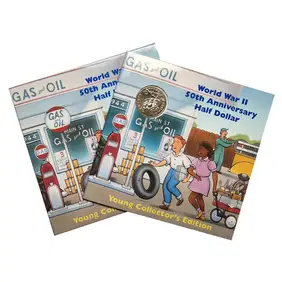
1993-P US World War II Commemorative Half Dollar - Young Collector's EditionKey Date Coins4.4(1.4k)See Sold PriceFeb 28, 2024