Ramusio Woodcut map of the AmericasRAMUSIO, Giovanni (1485-1577) & GASTALDI, Giacomo (c.1500-1566). Universale della Parte del Monde Nuovanmente Ritrovata. Woodcut. Venice: 1566 [1606]. 12 1/4" x 16 1/8" sheet, 23 1/2" x 27 1/2" framedSee Sold Price
Ramusio Woodcut Map of New FranceLa Nuova Francia. Giovanni Battista Ramusio (1485-1557). Woodcut. Venice, 1565. 12 1/2 x 15 1/2 sheet. This unusual map is the first map to focus on the area of New England and New France and the firsSee Sold Price
SoldMunster Woodcut Map of AmericasTabula novarum insularum...Sebastian Munster (1488-1552). Woodcut map with hand color in full. Basel, 1550 (state 5, Latin text). 11 1/2 x 14 3/4 inches visible, 20 1/2 x 22 inches framed. One of theSee Sold Price
SoldMunster Woodcut Map of the AmericasTauola dell'isole nuoue, le quali son nominate occidentali,...Sebastian Munster (1489-1552). Woodcut map. Basel, 1588. (State 8). 11 x 14 inches visible, 20 x 22 1/2 inches framed.See Sold Price
Ramusio map of Western Hemisphere 1556-1606Title: Universale della Parte del Mondo Nuovamente Ritrovata Author: Ramusio, Giovanni Battista Description: Woodcut map. Hemisphere, 27x26.3 cm. (10¾x10½") plus titling & directions in the margins.See Sold Price
SEBASTIAN MUNSTER (German 1488-1552)Map of the Americas Hand colored woodcut map (framed) 11 5/8" x 14 3/4" (sight) Provenance: Property from the Estate of Florence Knoll BassettSee Sold Price
SoldRAMUSIO, GIOVANNI BATTISTA. Sumatra. [Venice, 1565]. FrRAMUSIO, GIOVANNI BATTISTA Sumatra. [Venice, 1565]. Woodcut map of the island from the second edition of Ramusio's Delle navigationi et viaggi. The second edition was the same as the first editiSee Sold Price
SoldGiovanni Battista Ramusio Map of West Africa 1606Giovanni Battista Ramusio (1485-1557), "Parte De L'Africa," Venice, 1606. Woodcut map of part of West Africa. The delicate detail of the map includes illustrations of sea Monsters, ships, African peopSee Sold Price
SoldMuenster's map of the Americas, 1574Title: Die neüwen Inseln/ so hinder Hispanien gegen Orient bey dem land Indie ligen Author: Münster, Sebastian Description: Woodcut map, hand-colored (later). 25.2x33.8 cm. (10x13¼").One of the mosSee Sold Price
Soldc.1600 Swiss Map of the Americas.Attributed to Sebastian Munster via 2005 Auction Catalogue with the title: Americæ sive Novi Orbis, Nova. Published in Basel by Sebastian Petri. Woodcut map, modern hand-coloring plus German title atSee Sold Price
SoldMunster Map of AmericasTabula novarum insularum, quas Diversis respectibus Occidentales & Indianas uocant. Sebastian Munster (1488-1552). Woodcut map. Basel, Henri Petri, 1559. 11 1/4 x 14 3/4 inches visible, 19 1.4 x 22 3/See Sold Price
Munster Americas MapMunster, Sebastian (1488-1552). Le table des neufues lefquells on appelle isle d'occifent & d'Indie pour divers regard. Woodcut map. Basel, 1540 (State 12, 1569). 11 1/2" x 15 1/4" sheet, 23" x 26 1/2See Sold Price
SoldMuenster's map of the Americas, 1564Title: Die neüwen Inseln/ so hinder Hispanien gegen Orient bey dem land Indie ligen Author: Münster, Sebastian Description: Woodcut map. 25.2x33.8 cm. (10x13¼"). One of the most influential early mSee Sold Price
SoldRamusio Map of New FranceRAMUSIO, Giovanni Battista (1485-1557).La Nuova Francia.Woodcut map.Venice, 1565.12 1/2" x 15 1/2" sheet.This unusual map is the first map to focus on the area of New England and New France and the fiSee Sold Price
SoldRAMUSIO, GIOVANNI BATTISTA. Universale Della Parte delRAMUSIO, GIOVANNI BATTISTA. Universale Della Parte del Mondo Nuovamente Ritrovata. Double-page single-hemispheric woodcut map of the New World. 12x15½ inches sheet size; center fold verso gentlySee Sold Price
Ramusio (Giovanni Battista) - Parte del Africa,West Africa below the Tropic of Cancer, titled in the map, with numerous vessels, sea monsters, settlements, figures and animals, 1st edtion before page numbers and damage to the block, woodcut map, 2See Sold Price
Ramusio New World VoyagesRAMUSIO, Giovanni Battista (1485-1557). Delle navigationi et Viaggi. Venice: Giunti, 1563, 1606, 1556. 3 volumes, folio (11 ¾ x 8 ¼ inches). Volume one with 3 double-page woodcut maps ("Prima TavolaSee Sold Price
SoldMunster map of America 1614Heading: (Americas) Author: Münster, Sebastian Title: Americæ sive Novi Orbis, Nova Descriptio Place Published: Basel Publisher:Sebastian Petri Date Published: 1588-[1614] Description:See Sold Price
SoldMap of Sumatra, 1556Heading: Author: Ramusio, Giovanni Battista Title: Sumatra Place Published: Venice Publisher: Date Published: 1556- Description: Woodcut map, hand-colored (later). 26.7x36.See Sold Price
SoldMuenster, Tabula Novarum Insularum, map, 1550[Americas]. Tabula Novarum Insularum, Quas Diversis Respectibus Occidentales & Indianas Vocant. Woodcut map of the New World as its geography was understood at the time of publication. From the 1550 LSee Sold Price
SoldMunster (Sebastian) - Americae Novi Orbis, NovaMunster second map of the Americas, based on that of Ortelius, woodcut map, 315 x 360mm., German text verso, central vertical fold, [Basel], [1598].See Sold Price
Isola SpagnuolaTitle/Content of Map: Isola Spagnuola Cartographer: RAMUSIO, GIOVANNI BATTISTA (1485-1557) Height (inches): 6.75 Width (inches): 10.6Year: 1556 Full page woodcut map of the island of Hispaniola with tSee Sold Price
Sold[Munster (S)] Americæ Sive Novi Orbis,[Munster (Sebastian)] Americæ Sive Novi Orbis, Nova Descriptio,the Americas, with large title cartouche and gothic text above, woodcut map, 310 x 365mm., headpiece and German text on verso, ceSee Sold Price
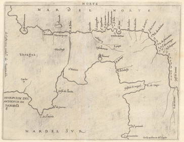
SoldAmericas.- Central America.- Cockburn (John) JourneyAmericas.- Central America.- Cockburn (John) Journey over Land, from the Gulf of Honduras to the Great South-Sea, first edition, folding engraved map, woodcut initials and head- & tail-pieces, 3pp. adSee Sold Price
Chatelain - Map of the Americas and Details and Insets of Government CounselsTrillium Antique Prints & Rare Books4.5(30)See Sold PriceFeb 24, 2024
Chatelain - 3 Maps of the British Isles (England, Ireland, Scotland)Trillium Antique Prints & Rare Books4.5(30)See Sold PriceFeb 24, 2024
1729 GERMANIA SACRA by M. Hansiz BLINDSTAMPED PIGSKIN antique FOLIO w/ MAPJasper524.5(9.8k)See Sold PriceFeb 27, 2024
1675 ELZEVIER JULIUS CAESAR antique ILLUSTRATED w/ MAPS ROMAN HISTORYJasper524.5(9.8k)See Sold PriceFeb 27, 2024
1558 SCANDINAVIA SWEDEN ILLUSTRATED HISTORY Gothorum Sveonumque historia antiqueJasper524.5(9.8k)See Sold PriceFeb 27, 2024
World map.- Macrobius (Ambrosius Aurelius Theodosius) In somnium Scipionis, Libri II. Saturnaliorum,Forum Auctions4.3(53)See Sold PriceFeb 29, 2024
Bible, English.- Bible (The): that is, the Holy Scriptures contained in the Olde and Newe Testament,Forum Auctions4.3(53)See Sold PriceFeb 29, 2024


![RAMUSIO, GIOVANNI BATTISTA. Sumatra. [Venice, 1565]. Fr (1 of 1)](https://p1.liveauctioneers.com/197/22128/7657774_1_x.jpg?height=282&quality=70)


![[Munster (S)] Americæ Sive Novi Orbis, (1 of 0)](https://p1.liveauctioneers.com/dist/images/placeholder.jpg?height=282&quality=70)