ATLAS of ANTIENT GEOGRAPHY by SAMUEL BUTLER 1843John McInnis Auctioneers,LLC4.6(502)See Sold PriceFeb 24, 2024
18TH C. ANTIQUE MAP: FRENCH & INDIAN WAR, FRAMEDThomaston Place Auction Galleries4.4(386)See Sold PriceFeb 24, 2024
Rand McNally Railroad Map Cabinet w/ 21 Railroad MapsRail & Road Auctions4.6(165)See Sold PriceMar 08, 2024
Keith Haring - Ink on New York Map, Best Buddies, Inscribed, Signed, and DatedSapphire Auction Gallery4(67)See Sold PriceMar 02, 2024
LATE 17TH C. FRENCH MAP OF THE NEW WORLD BY ALEXIS-HUBERT JAILLOT (1632-1712)Thomaston Place Auction Galleries4.4(386)See Sold PriceFeb 24, 2024
Central Railroad of New Jersey Map of Sandy Hook Route-ca. 1903JM Hobby Supply and Railroad Artifact Auctions4.4(126)See Sold PriceFeb 24, 2024
Lot of Six Mixed Atlas Box Cars-HO Scale-New in BoxJM Hobby Supply and Railroad Artifact Auctions4.4(126)See Sold PriceFeb 25, 2024
Rand McNally/Santa Fe Railroad Map of Iowa-1912JM Hobby Supply and Railroad Artifact Auctions4.4(126)See Sold PriceFeb 24, 2024
NICOLAES VISSCHER (NETHERLANDS, 1618-1709) MAP OF THE NEW WORLDThomaston Place Auction Galleries4.4(386)See Sold PriceFeb 24, 2024
17TH C. WORLD MAP BY NICOLAES VISSCHER (NETHERLANDS, 1618-1709)Thomaston Place Auction Galleries4.4(386)See Sold PriceFeb 24, 2024
Lot of Six Mixed Atlas Cabooses-HO Scale-New in BoxJM Hobby Supply and Railroad Artifact Auctions4.4(126)See Sold PriceFeb 25, 2024
Soldc.1880 New Railroad and County Map of New YorkImage Type: Hand Colored Engraving Scale: 36 miles to 1 inch>br>Dimensions: 13 3/4"(l) x 11 1/2"(w) For your consideration is a hand-colored engraved railroad and county map of New York. This highly dSee Sold Price
SoldAN ANTIQUE MAP, "Railroad and County Map of Texas," NEWAN ANTIQUE MAP, "Railroad and County Map of Texas," NEW YORK, CIRCA 1886, color engraving on paper, a page fragment from Grant’s Rail Road & Business Atlas, after George F. Cram (1842-1928). 16See Sold Price
SoldAN ANTIQUE MAP, "Railroad and County Map of IndianAN ANTIQUE MAP, "Railroad and County Map of Indian Territory," New York, 1885-1893, hand colored engraving on paper, published by A.A. Grant, plates 165-165, page fragments from an atlas. 16 1/2" x 22See Sold Price
SoldSCARBOROUGH'S NEW RR, POST OFFICE, TOWNSHIP & CTY. MAPSCARBOROUGH'S NEW RAILROAD, POST OFFICE, TOWNSHIP & COUNTY MAP OF NEW YORK, 19TH C., 43" X 48"See Sold Price
SoldEarly Roll-Up New York MapEarly roll-up New York map, "SCARBOROUGH'S / NEW / RAILROAD, POST OFFICE, TOWNSHIP / AND COUNTY MAP OF / NEW YORK". Imperfections. 48" x 41"See Sold Price
SoldVINTAGE TRAVEL EPHEMERA, UNCOUNTED LOTVINTAGE TRAVEL EPHEMERA, UNCOUNTED LOT, including cruise line menus, passenger lists, brochures, and postal covers, National Publishing Co. Railroad, Post Office, Township and County Map of New York,See Sold Price
Soldscarborough's map of new york 19031903 Scarborough's new railroad, post office, township and county map of New York with distances between stations. Tears; stained; needs repair. 49 1/2 inches wide x 40 inches high.See Sold Price
SoldAntique New York State Map 1903 Color Roll Up RR Map1903 Scarborough's New Railroad, Post Office, Township and County Map of New York. Color map, compiled from the latest government and state surveys and original sources of the era. Insets: Map of NewSee Sold Price
SoldEMPIRE GROUP 1898 ROLL DOWN MAP A NEW RAILROAD, POSTEMPIRE GROUP 1898 ROLL DOWN MAP A NEW RAILROAD, POST OFFICE TOWNSHIP AND COUNTY MAP OF NEW YORK, NEW JERSEY, AND PENNSYLVANIA. NATIONAL PUBLISHING COMPANY, BOSTON 1898. BOTTOM 26" IN BETTER CONDITION,See Sold Price
SoldGroup of Two Colton's Pocket Mapsincluding Colton's 1857 Map Of the United States 6" x 3 3/4" with 27" x 37 1/2" folding map, Colton's 1860 Railroad & County Map 6 1/4" x 4" with 32 1/4" x 38 1/2" folding map together with New York SSee Sold Price
Sold1875 Colton's Map of the United States1875 Colton's Map of the United StatesCOLTON'S NEW RAILROAD & COUNTY MAP OF THE UNITED STATES THE CANADAS &c (New York: G. W. and C. B. Colton & Co., 1875), tipped into boards (6 x 4 in.), with insetSee Sold Price
SoldFour Maps of Idaho largest 20 1/4 x 16 inchesFour Maps of Idaho includes Johnson's Nebraska, Dakota, Idaho and Montana map (published by A.J. Johnson, New York ca. 1865), the Railroad and County Map of Idaho (published by A.A. Grant, New York, 1See Sold Price
Sold1906 MAP OF NY RAND MCNALLY ROLL DOWN, AS IS CONDIT1906 MAP OF NY RAND MCNALLY ROLL DOWN, AS IS CONDITION, BOTTOM COMING OFF, AS PICTURED. TOP GOOD. RAND MCNALLY 1906 MAP OF NEW YORK NEW COUNTY AND RAILROAD, MAPS ON BOTH SIDES. VERY LARGE,See Sold Price
New York by Mitchell, 1872County Map of the State of New York. Large two-page format hand colored by county. Includes five inset maps: Troy, Albany, Harbor and Vicinity of New York, Buffalo and Rochester. Shows railroads, canaSee Sold Price
SoldRAILROAD MAPAMENDED LINE OF NEW YORK, SUSQUEHANNA & WESTERN RAILROAD - SUSSEX COUNTY, NEW JERSEY 48"X16"See Sold Price
Sought-after 2-pg map of New York, Mitchell 1850Extremely detailed and large map of New York, hand-colored when published. Shows railroads, towns, rivers, canals, steamship routes, and more. Map is framed by population tables for counties and townsSee Sold Price
SoldNew York City & State Maps & View Publications (2)1) Rand McNally Pocket Maps for Tourists, Travelers & Shippers, General and Commercial Business Reference. 1931. Contains counties, cities, towns, auto roads, railroads & steamship lines, hotels and 1See Sold Price
[Maps & Atlases] Colton, G(eorge). Woolworth, G.[Maps & Atlases] Colton, G(eorge). Woolworth G. Woolworth Colton's New Guide Map of the United States & Canada, with Railroads, Counties etc New York: G.W. & C.B. Colton & Co., 1874. Large handsome haSee Sold Price
SoldBridgehampton & Watermill, Long Island, 1902Original engraving published by E. Belcher Hyde from "Atlas of Suffolk County, Long Island, New York," Philadelphia, 1902. Map features family names, historic buildings and railroad routes. DimensionsSee Sold Price
SoldHISTORY OF WAYNE COUNTY NEW YORK 1789 TO 1877 1877HISTORY OF WAYNE COUNTY NEW YORK 1789 TO 1877 1877 First Edition Folio Decorative Gilt Antique Oversized Illustrated Maps Views Scenery Lake Ontario Palmyra Birthplace Mormon Church Hudson Railroad MiSee Sold Price
SoldTown of Dover in Dutchess County, Atlas of New York byOriginal steel engraving by Augustus Mitchell, 1881. Map features city streets & railroads. Dimensions: 15” x 12”See Sold Price
Sold1875 Railroad Map Of New York1875 Railroad map of New York. Revised map of the railroads of State of N.Y.. Prepared under the direction of S.H. Sweet & D.M. Greene 1875. Hand colored. Folds as issued. 28 1/2" x 34 3/4".See Sold Price
SoldColton's City and County Map of New-York 1867Heading: (New York) Author: Title: Colton's City and County Map of New-York Place Published: New York Publisher:G.W. and C.B. Colton Date Published: 1867 Description: Large foldSee Sold Price
Warner Beers: Map of Mid Atlantic, Midwest, 1875Map: 1875 Warner Beers Map of Mid Atlantic and Midwest United States -- County Map of New York, New Jersey, Pennsylvinia, Ohio, Deleware, Maryland, Virginia, West Virginia Cartographer: Warner Beers YSee Sold Price
Michigan Southern and Northern Indiana RR 14th Annual Report-February 28, 1869JM Hobby Supply and Railroad Artifact Auctions4.4(126)See Sold PriceFeb 24, 2024
1892 Adams and Bowles New Road Map of the State of New YorkJM Hobby Supply and Railroad Artifact Auctions4.4(126)See Sold PriceFeb 24, 2024
American Express/New York Central Railroad Map of the United States-1934JM Hobby Supply and Railroad Artifact Auctions4.4(126)See Sold PriceFeb 24, 2024
Crams Railroad Map of New York-1881JM Hobby Supply and Railroad Artifact Auctions4.4(126)See Sold PriceFeb 24, 2024
Crams Township and Railroad Map of New York-1890JM Hobby Supply and Railroad Artifact Auctions4.4(126)See Sold PriceFeb 24, 2024
Erie Railway Tourist Book/Magazine-1874JM Hobby Supply and Railroad Artifact Auctions4.4(126)See Sold PriceFeb 24, 2024
New York Central RR The Adirondacks Brochure 1916-1917JM Hobby Supply and Railroad Artifact Auctions4.4(126)See Sold PriceFeb 24, 2024
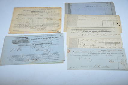
Bills of Lading, Checks, other Paper from 1840s-1860s-Eastern USA RailroadsJM Hobby Supply and Railroad Artifact Auctions4.4(126)See Sold PriceFeb 24, 2024
New York Central and Hudson River RR Public Timetable-November 3, 1901JM Hobby Supply and Railroad Artifact Auctions4.4(126)See Sold PriceFeb 24, 2024
Vintage County Map Of NY State Plate EngravingThe Benefit Shop Foundation Inc.4.3(2.9k)See Sold PriceFeb 28, 2024
Group of New York Central Railroad Paper - Rule Books, Employee Timetables, Stationary, Log Books,Rail & Road Auctions4.6(165)See Sold PriceMar 07, 2024
Early Pennsylvania Railroad Literature - 1881 New York and Chicago Limited Timetable Brochure andRail & Road Auctions4.6(165)See Sold PriceMar 07, 2024
1855 Map of New York & Erie Railroad and 1917 Trespassing On Railway Property Is A MisdemeanorRail & Road Auctions4.6(165)See Sold PriceMar 07, 2024
Group of Ten Railroad Photographs, Maps, and Prints - New Jersey, Long Island, and New YorkRail & Road Auctions4.6(165)See Sold PriceMar 07, 2024
Thirty-Three Assorted Railroad and Transit Buttons - Kansas City Southern, United Transit ofRail & Road Auctions4.6(165)See Sold PriceMar 07, 2024
Pair of Dietz Vesta Railroad Lanterns - New York Central and Union? RailroadRail & Road Auctions4.6(165)See Sold PriceMar 07, 2024
1867 Map of the Railroads of The State of New YorkRail & Road Auctions4.6(165)See Sold PriceMar 08, 2024
Twelve Cleveland, Cincinnati, Chicago & St. Louis Railroad / New York Central Employee TimetablesRail & Road Auctions4.6(165)See Sold PriceMar 08, 2024
ANDREW RAYMOND JANSON OIL ON BOARD ADIRONDACKSCharleston Estate Services Ltd.4.5(58)See Sold PriceMar 03, 2024


![[Maps & Atlases] Colton, G(eorge). Woolworth, G. (1 of 2)](https://p1.liveauctioneers.com/65/192593/97105500_1_x.jpg?height=282&quality=70&version=1611610147)