SoldPtolomaeus (Claudius) Tertia Asiae TabulaPtolomaeus (Claudius) Tertia Asiae Tabula, the Caucasus, woodcut map, with hand-colouring, on 2 sheets joined, 370 x 500mm., a few light stains and discolouration, [Rome, Petrus de Turre], [cSee Sold Price
Sold[Ptolomaeus (Claudius)] Tertia Asiae Tabula[Ptolomaeus (Claudius)] Tertia Asiae Tabula,the Caucasus, woodcut map on 2 sheets joined, with hand-colouring, 370 x 500mm., a few light stains and discolouration, printer's creases, light offSee Sold Price
SoldPtolomaeus (Claudius) Tertia Asiae TabulaPtolomaeus (Claudius) Tertia Asiae Tabula, engraved map, 550 x 410mm., on two sheets joined, slight spotting and browning, mostly marginal, surface dirt, [Rome], [Petrus de Turre], [1490].See Sold Price
SoldPtolomaeus (Claudius) Septima Asiae TabulaPtolomaeus (Claudius) Septima Asiae Tabula, the Caspian Sea region, woodcut map with hand-colouring, image 280 x 530mm., on two sheets joined, surface dirt and faint staining to the the lowerSee Sold Price
Sold[Ptolomaeus (Claudius)] Nona Asiae Tabula[Ptolomaeus (Claudius)] Nona Asiae Tabula,Pakistan, woodcut map on 2 sheets joined, with hand-colouring, 375 x 290mm., wear and staining to join, with occasional surface loss, verso strengthenSee Sold Price
[Ptolomaeus (Claudius)] Undecima Asiae Tabula[Ptolomaeus (Claudius)] Undecima Asiae Tabula,South East Asia east of the Ganges, the area of Bangladesh and Burma, woodcut map, with some original hand-colouring, 390 x 515mm., trimmed on theSee Sold Price
[Ptolomaeus (Claudius)] Decima Asiae Tabula[Ptolomaeus (Claudius)] Decima Asiae Tabula,India west of the Ganges, the right border scaled from the 3rd to the 11th parallel and with 4 climate zones, woodcut map, 350 x 530mm., repairs toSee Sold Price
SoldPtolomaeus (Claudius) Quinta Asiae TabulaPtolomaeus (Claudius) Quinta Asiae Tabula, Persia, woodcut map, 350 x 525mm., central vertical fold, repaired, with slight surface accretion, a few areas of minor staining, browning and surfacSee Sold Price
Sold[Ptolomaeus (Claudius)] Tertia Africae Tabula[Ptolomaeus (Claudius)] Tertia Africae Tabula,North Africa and Egypt from the second edition of Conrad Swenheym's 'Rome' Cosmographia, copper engraved map on two sheets, joined, the sheet 430See Sold Price
SoldPtolomaeus (Claudius) Tertia Africae TabulaPtolomaeus (Claudius) Tertia Africae Tabula, Ptolemaic map showing Libya, Egypt and the Mediterannean coast to the Sinai peninsula, woodcut map with hand-colouring, 350 x 540mm., central vertiSee Sold Price
SoldPtolomaeus (Claudius) Decima Asiae TabulaPtolomaeus (Claudius) Decima Asiae Tabula, Ptolemaic showing north west India between the Indus and the Ganges, including the Himalayas, woodcut map with outline hand-colouring, image 340 x 48See Sold Price
Sold[Ptolomaeus (Claudius)] Decima Asiae Tabula[Ptolomaeus (Claudius)] Decima Asiae Tabula,India, woodcut map on 2 sheets joined, with hand-colouring, 340 x 495mm., wear to centre, verso strengthened with archival paper, small stain adjaceSee Sold Price
Sold[Ptolomaeus (Claudius)] Quinta Asiae Tabula[Ptolomaeus (Claudius)] Quinta Asiae Tabula,Persia, woodcut map on 2 sheets joined, with hand-colouring, 355 x 525mm., wear and some staining to join, with occasional surface loss, verso strenSee Sold Price
SoldPtolomaeus (Claudius) Quinta Asiae TabulaPtolomaeus (Claudius) Quinta Asiae Tabula, Iran, woodcut map with outline hand-colouring, image 360 x 550mm., central vertical fold, reinforced verso, some minor adjacent wear, some small, mosSee Sold Price
SoldPtolomaeus (Claudius) Octava Asiae TabulaPtolomaeus (Claudius) Octava Asiae Tabula, Mongolia and northern China, woodcut map with hand-colouring, image 355 x 500mm, worn central vertical fold, repaired verso, some small, mostly margiSee Sold Price
SoldPtolomaeus (Claudius) Octava Asiae TabulaPtolomaeus (Claudius) Octava Asiae Tabula, engraved map of Central Asia, image 355 x 500mm, worn central vertical fold, repaired, some small areas of light staining, mostly marginal, browning,See Sold Price
SoldPtolomaeus (Claudius) Nona Asiae TabulaPtolomaeus (Claudius) Nona Asiae Tabula, depicting Pakistan, the Indus and part of the Rann of Kutch, engraved map, 380 x 295mm., central vertical fold, repaired, with slight surface accretionSee Sold Price
SoldPtolomaeus (Claudius) Secunda Asiae TabulaPtolomaeus (Claudius) Secunda Asiae Tabula, engraved map of the Caucassus region, southern Russia bordering on the Black sea, image 355 x 500mm., central vertical fold, reinforced verso, a fewSee Sold Price
SoldPtolomaeus (Claudius) Nona Asiae TabulaPtolomaeus (Claudius) Nona Asiae Tabula,Pakistan, woodcut map with hand-colouring, 375 x 290mm., central vertial fold, adjacent wear and staining, with occasional surface loss, repairs to loweSee Sold Price
SoldPtolomaeus (Claudius) Septima AsiaePtolomaeus (Claudius) Septima Asiae Tabula, engraved map of the Caspian Sea region, the sheet 550 x 410mm., one central vertical crease, browning, mostly marginal, several short marginal tearsSee Sold Price
SoldPtolomaeus (Claudius) Tabula Asiae XIPtolomaeus (Claudius) Tabula Asiae XI, the Indian sub-continent, engraved map, 175 x 235mm., one central vertical fold, with slight splitting, Latin text verso, faint browning, [Venice], [1574See Sold Price
SoldPtolomaeus (Claudius) Tabula Asiae XIPtolomaeus (Claudius) Tabula Asiae XI, the Indian sub-continent, engraved map, 175 x 235mm., one central vertical fold, with slight splitting, Latin text verso, faint browning, [Venice], [1574See Sold Price
SoldPtolomaeus (Claudius) after. Tabula Asiae XIIPtolomaeus (Claudius) after. Tabula Asiae XII; Tabula Asiae XI; Tabula Asiae VIII; Tabula Asiae IX,the first depicting Taprobana, thought to be Sri Lanka, the others, regions of India, all butSee Sold Price
[Ptolomaeus (Claudius)] Taprobana [Tabula Asiae XI[Ptolomaeus (Claudius)] Taprobana [Tabula Asiae XII],Ceylon and surrounding islands, with tip of India, panel to left side depicting elephant and tree above, with text below, Vartomannus TaproSee Sold Price
17TH C. WORLD MAP BY NICOLAES VISSCHER (NETHERLANDS, 1618-1709)Thomaston Place Auction Galleries4.4(386)See Sold PriceFeb 24, 2024
NICOLAES VISSCHER (NETHERLANDS, 1618-1709) MAP OF THE NEW WORLDThomaston Place Auction Galleries4.4(386)See Sold PriceFeb 24, 2024
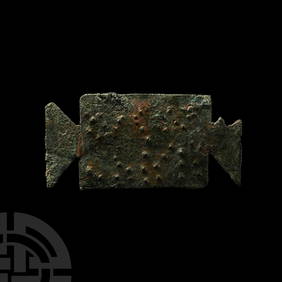
Ancient Roman Imperial Coins - Claudius - Romano-British Imitation - SPQR Plated DenariusTimeLine Auctions Ltd.4.5(183)See Sold PriceMar 09, 2024
Ancient Roman Imperial Coins - 3 Claudius II - AE AntoninianusTimeLine Auctions Ltd.4.5(183)See Sold PriceMar 09, 2024
Ancient Roman Imperial Coins - Claudius II (Gothicus) - Mars AE AntoninianusTimeLine Auctions Ltd.4.5(183)See Sold PriceMar 09, 2024
Ancient Roman Imperial Coins - Claudius - AE AsTimeLine Auctions Ltd.4.5(183)See Sold PriceMar 09, 2024
Nova Totius Full Color Geographical World MapThe Benefit Shop Foundation Inc.4.3(2.9k)See Sold PriceFeb 28, 2024
269-270 AD Claudius II - Roman Egypt - TatradrachmWeatherham Estate Treasures3.9(157)See Sold PriceMar 07, 2024
Egypt Alexandria Claudius II 268-270 Tetradrachm Roman coinArs Coin Wien4.5(42)See Sold PriceFeb 25, 2024
Claudius ASH & Sons : Rare applique articule de dentiste en métal nickelé sur rotule. Plaque duValoir Pousse-Cornet4.3(4)See Sold PriceFeb 24, 2024
De Jode, Rare, pub. 1593 - Map of the Middle East, Eastern Asia (Primae Partis Asiae accurataTrillium Antique Prints & Rare Books4.5(30)See Sold PriceFeb 24, 2024
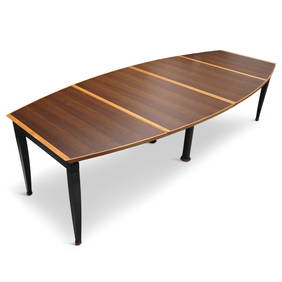
Tabula Magna Dining Table by Oscar Tosquets Blanca for Driade Aleph (1991)Jasper524.5(9.8k)See Sold PriceFeb 27, 2024
I, Claudius by Robert Graves, The Folio Society BookPassion For Antiques3.9(23)See Sold PriceMar 10, 2024
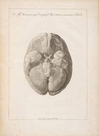
SOEMMERING, SAMUEL THOMAS.1755-1830. Tabula baseos encephali. Frankfurt: by the author, 1799.Bonhams4.1(305)See Sold PriceJun 18, 2024


![[Ptolomaeus (Claudius)] Tertia Asiae Tabula (1 of 1)](https://p1.liveauctioneers.com/410/14124/4342224_1_x.jpg?height=282&quality=70&version=1192724045)


![[Ptolomaeus (Claudius)] Nona Asiae Tabula (1 of 0)](https://p1.liveauctioneers.com/dist/images/placeholder.jpg?height=282&quality=70)
![[Ptolomaeus (Claudius)] Undecima Asiae Tabula (1 of 1)](https://p1.liveauctioneers.com/410/10165/2288984_1_x.jpg?height=282&quality=70)
![[Ptolomaeus (Claudius)] Decima Asiae Tabula (1 of 1)](https://p1.liveauctioneers.com/410/10165/2289100_1_x.jpg?height=282&quality=70)

![[Ptolomaeus (Claudius)] Tertia Africae Tabula (1 of 1)](https://p1.liveauctioneers.com/410/22701/7943923_1_x.jpg?height=282&quality=70)


![[Ptolomaeus (Claudius)] Decima Asiae Tabula (1 of 1)](https://p1.liveauctioneers.com/410/14124/4342333_1_x.jpg?height=282&quality=70&version=1192724045)
![[Ptolomaeus (Claudius)] Quinta Asiae Tabula (1 of 1)](https://p1.liveauctioneers.com/410/14124/4342409_1_x.jpg?height=282&quality=70&version=1192724045)


![[Ptolomaeus (Claudius)] Taprobana [Tabula Asiae XI (1 of 1)](https://p1.liveauctioneers.com/410/22701/7943911_1_x.jpg?height=282&quality=70)