Marc Chagall-Limited Edition -Paris Opera Ceiling after ChagallArt Legacy Auctions4.5(219)See Sold PriceFeb 24, 2024
Salvador Dali Pantagruel Limited Edition Lithograph Hand signed and numberedArt Legacy Auctions4.5(219)See Sold PriceFeb 24, 2024
Pablo Picasso Bouquet of Peace Collection Domaine Picasso Limited Edition on paper.Art Legacy Auctions4.5(219)See Sold PriceFeb 24, 2024
A RARE MAXFIELD PARRISH JACK AND THE BEANSTALK PRINTSoulis Auctions4.8(953)See Sold PriceFeb 24, 2024
LARGE MECHANICAL PRINT 'STARS' AFTER MAXFIELD PARRISHSoulis Auctions4.8(953)See Sold PriceFeb 24, 2024
Heinrich Aldegrever, etc. 15 old master prints. 16th-17th centuries. Aldegrever works include "ManTremont Auctions4.6(294)See Sold PriceFeb 25, 2024
PTOLEMY"CITY MAP, VENETIA"This Is A PTOLEMY Giclee on CANVAS Titled "CITY MAP, VENETIA"Measuring - 22 3/8 x 30 in.This Giclée is high-resolution and of the highest quality, has a color permanence rating in excess of 100 yearsSee Sold Price
SoldPTOLEMY"CITY MAP, CONSTANTINOPLE"This Is A PTOLEMY Giclee on CANVAS Titled "CITY MAP, CONSTANTINOPLE"Measuring - 22 1/8 x 30 in.This Giclée is high-resolution and of the highest quality, has a color permanence rating in excess of 10See Sold Price
PTOLEMY"CITY MAP, ALEXANDRIA"This Is A PTOLEMY Giclee on CANVAS Titled "CITY MAP, ALEXANDRIA"Measuring - 23 1/8 x 30 in.This Giclée is high-resolution and of the highest quality, has a color permanence rating in excess of 100 yeSee Sold Price
PTOLEMY - CITY MAP, CONSTANTINOPLEPtolemy - City Map, Constantinople - Giclée On Canvas - 32 3/8 X 44 In. A Giclée Print Is The Highest Quality Print Available Today. Because There Is No Visible Dot Screen Pattern, The Resulting ImaSee Sold Price
SoldPTOLEMY"CITY MAP, MEDIOLANO"This Is A PTOLEMY Giclee on CANVAS Titled "CITY MAP, MEDIOLANO"Measuring - 22 x 30 in.This Giclée is high-resolution and of the highest quality, has a color permanence rating in excess of 100 years.See Sold Price
PTOLEMY"CITY MAP, DAMASCUS"This Is A PTOLEMY Giclee on CANVAS Titled "CITY MAP, DAMASCUS"Measuring - 22 x 30 in.This Giclée is high-resolution and of the highest quality, has a color permanence rating in excess of 100 years. PSee Sold Price
PTOLEMY"CITY MAP, ROMA"This Is A PTOLEMY Giclee on CANVAS Titled "CITY MAP, ROMA"Measuring - 22 x 30 in.This Giclée is high-resolution and of the highest quality, has a color permanence rating in excess of 100 years. PrintSee Sold Price
PTOLEMY - CITY MAP, DAMASCUSPtolemy - City Map, Damascus - Giclée On Canvas - 32 1/4 X 44 In. A Giclée Print Is The Highest Quality Print Available Today. Because There Is No Visible Dot Screen Pattern, The Resulting Image HasSee Sold Price
PTOLEMY"CITY MAP, FLORENTIA"This Is A PTOLEMY Giclee on CANVAS Titled "CITY MAP, FLORENTIA"Measuring - 22 1/4 x 30 in.This Giclée is high-resolution and of the highest quality, has a color permanence rating in excess of 100 yeaSee Sold Price
PTOLEMY"CITY MAP, HEIRUSALUM"This Is A PTOLEMY Giclee on CANVAS Titled "CITY MAP, HEIRUSALUM"Measuring - 21 3/4 x 30 in.This Giclée is high-resolution and of the highest quality, has a color permanence rating in excess of 100 yeSee Sold Price
PTOLEMY"CITY MAP, CHAIRUM"This Is A PTOLEMY Giclee on CANVAS Titled "CITY MAP, CHAIRUM"Measuring - 22 7/8 x 30 in.This Giclée is high-resolution and of the highest quality, has a color permanence rating in excess of 100 yearsSee Sold Price
Sold5 map reference books[Reference]. 5 Titles. Vp:vp. 4to/folio. 4 cloth in dj, 1 in wraps. Very good or better. ++ Ashley Baynton-Williams. Town And City Maps Of The British Isles 1800-1855. (1992). ++ Claudius Ptolemy. TheSee Sold Price
SoldThree Maps of A. J. Johnson's , "Venetia, Kingdom ofThree Maps of A. J. Johnson's , "Venetia, Kingdom of Italy," 1863, hand colored, H.- 26 1/2 in., W.- 18 in. Italy, 1863 (3 Pcs.)See Sold Price
Six maps of Austria and Central Europe16th - 18th Century, including "Tabula Europae IIII" from Magini's edition of Ptolemy (Cologne: 1597); "Graecia" after Ptolemy, from the same book; "Germania," after Mercator; and "A Plan of the CitySee Sold Price
1574 VenetiaBy: Braun and Hogenberg Date: 1574 (Published) Cologne Dimensions: 13.25 x 18.8 inches (33.7 x 47.8 cm) This striking bird's-eye view of Venice appeared in the first atlas of cities, Civitates Orbis TSee Sold Price
Sold1837 New York as it is History Colleges City Map Census1837 New York as it is History Colleges City Map Census Religious Institution The mid-19th century book, ‘New York as it is,’ gives an overview of New York City as it existed in 1837 with an incluSee Sold Price
SoldMartin Waldseemuller Ptolemy Map of North AfricaMartin Waldseemuller (1470-1520)/ Claudius Ptolemy (ca. 100 CE-ca. 170 CE), "Tabula Moderna Prime Partis Aphricae," Strassburg, ca. 1513. This hand colored map of northern Africa is from WaldseemullerSee Sold Price
SoldNew York City MapEarly "Coast Chart No. 20" N.Y.C. map. Published 1866". 28" x 31".See Sold Price
SDUK: Antique City Map of Warsaw, 1847Title/Content of Map: 'WARSAW (WARSZAWA)' antique town city map plan. Building profiles. Colour. Date Printed: 1847 Image Size: Approx 31.5 x 39.5cm, 12.5 x 15.5 inches (Large) Type: Antique steel engSee Sold Price
SoldVintage Humphrey Phelps New York City MapVintage Humphrey Phelps New York City Map, inscription to map reads ‘New York City Map New York Published by H Phelps, No 18 Beekman Street’, ‘Entered according to act of Congress in the year 18See Sold Price
SoldLorenz Fries Ptolemy Map of Sri Lanka 1541Lorenz Fries (1489-1532), "Tabula Duodecima Asiae continet Taprobanam insulam," Vienna, 1541. From Ptolemy (ca. 100 CE-170 CE), edited by Michael Servetus (ca. 1511-1553) "Geographia," Vienna, 1541. TSee Sold Price
SoldPtolemy: Map of Bactria Scythia North India, 1597Map: Tabula Asiae VIII Cartographer: Ptolemy, Magini / Porro, P.Keschedt Place & Date: Cologne / 1597 Size: 6 3/4" x 5 1/4" Condition: b&w; overall age toning The eighth Ptolemaic Asia map from the MaSee Sold Price
SoldU.S. Army Tokyo City Map for Stationed Soldiers, 1948Item: Map of the City of Tokyo, Japan Compiled by the U.S. Army 64th Engineer Battalion and updated in 1954 by the U.S. Army 29th Engineer BattalionDate: ca. 1948 Full Size: 28 1/2 x 37 1/4 inches FolSee Sold Price
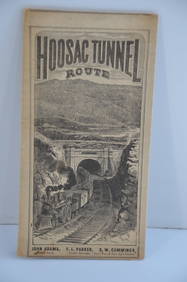
Fitchburg Railroad 1880 Hoosac Tunnel Route Public TimetableJM Hobby Supply and Railroad Artifact Auctions4.4(126)See Sold PriceFeb 24, 2024
George Hayward - Map of the City of New York 1854Dane Fine Art Auctions4.4(496)See Sold PriceMar 07, 2024
Collection of 10 Maps of Cities in Israel for TouristsLevy Auction House4.3(11)See Sold PriceFeb 27, 2024
Hand Colored Map of the city of Amsterdam 1720Global Auctions Company4.3(36)See Sold PriceMar 03, 2024
Mitchell - Map of the City of Washington (Washington, DC)Trillium Antique Prints & Rare Books4.5(30)See Sold PriceFeb 24, 2024
COLONIAL TOGO & BENIN (Dahomey). Porto Novo & Lomé city ville plans 1929 mapJasper524.5(9.8k)See Sold PriceFeb 28, 2024
COLONIAL TOGO & BENIN (Dahomey). Porto Novo & Lomé city ville plans 1931 mapJasper524.5(9.8k)See Sold PriceFeb 28, 2024
COLONIAL TOGO & BENIN (Dahomey). Porto Novo & Lomé city ville plans 1938 mapJasper524.5(9.8k)See Sold PriceFeb 28, 2024
Vintage Street Map of Pittsburgh, Pennsylvania - Rand McNallyProverde Auctions4.3(3)See Sold PriceFeb 28, 2024
Coca Cola 1993 New Orleans Basketball TubeRapid Estate Liquidators and Auction Gallery4.5(1.1k)See Sold PriceFeb 27, 2024
Laminated Unique Media New York City MapRapid Estate Liquidators and Auction Gallery4.5(1.1k)See Sold PriceFeb 29, 2024