ATLAS of ANTIENT GEOGRAPHY by SAMUEL BUTLER 1843John McInnis Auctioneers,LLC4.6(502)See Sold PriceFeb 24, 2024
18TH C. ANTIQUE MAP: FRENCH & INDIAN WAR, FRAMEDThomaston Place Auction Galleries4.4(386)See Sold PriceFeb 24, 2024
Rand McNally Railroad Map Cabinet w/ 21 Railroad MapsRail & Road Auctions4.6(165)See Sold PriceMar 08, 2024
Keith Haring - Ink on New York Map, Best Buddies, Inscribed, Signed, and DatedSapphire Auction Gallery4(67)See Sold PriceMar 02, 2024
LATE 17TH C. FRENCH MAP OF THE NEW WORLD BY ALEXIS-HUBERT JAILLOT (1632-1712)Thomaston Place Auction Galleries4.4(386)See Sold PriceFeb 24, 2024
Central Railroad of New Jersey Map of Sandy Hook Route-ca. 1903JM Hobby Supply and Railroad Artifact Auctions4.4(126)See Sold PriceFeb 24, 2024
Lot of Six Mixed Atlas Box Cars-HO Scale-New in BoxJM Hobby Supply and Railroad Artifact Auctions4.4(126)See Sold PriceFeb 25, 2024
Rand McNally/Santa Fe Railroad Map of Iowa-1912JM Hobby Supply and Railroad Artifact Auctions4.4(126)See Sold PriceFeb 24, 2024
NICOLAES VISSCHER (NETHERLANDS, 1618-1709) MAP OF THE NEW WORLDThomaston Place Auction Galleries4.4(386)See Sold PriceFeb 24, 2024
17TH C. WORLD MAP BY NICOLAES VISSCHER (NETHERLANDS, 1618-1709)Thomaston Place Auction Galleries4.4(386)See Sold PriceFeb 24, 2024
Lot of Six Mixed Atlas Cabooses-HO Scale-New in BoxJM Hobby Supply and Railroad Artifact Auctions4.4(126)See Sold PriceFeb 25, 2024
SoldPrint, 1548 Hand Colored Map of ParisPrint, 1548 Hand Colored Map of Paris . Used condition Framed size 13 3/4"h x 13"wSee Sold Price
SoldAfter Ignace-Gaston Pardies (French, 17th C.)After Ignace-Gaston Pardies (French, 17th Century) "Globi Coelestis", suite of six hand colored fascimile prints of the celestial maps, originally published in Paris, 1674, sight 11" x 11-1/4". All glSee Sold Price
SoldVictor Lavasseur. Map of Asia. 1830.Print of hand colored steel engraving titled Asie“.Author Victor Lavasseur.Engraved by unknown.From Atlas classique universel de Geographie anciene et moderne“ by Victor Levasseur. Paris. 1830.VicSee Sold Price
Victor Lavasseur. Map of Switzerland. 1830.Print of hand colored steel engraving titled Suisse“.Author Victor Lavasseur.Engraved by unknown.From Atlas classique universel de Geographie anciene et moderne“ by Victor Levasseur. Paris. 1830.VSee Sold Price
SoldThree Framed 18th and 19th Century Maps and a FramedThree Framed 18th and 19th Century Maps and a Framed Historical Engraving, a hand-colored Plan de la Ville et Faubourg De Paris, a Laurie & Whittle hand-colored New Map of Switzerland, a lithograph PlSee Sold Price
SoldA REPUBLIC OF TEXAS MAP, "Méxique," THUNOT DUVOTENAY,A REPUBLIC OF TEXAS MAP, "Méxique," THUNOT DUVOTENAY, PARIS, CIRCA 1843, hand-colored lithograph on paper, Thunot Duvotenay, French cartographer, Charles Smith, English plate engraver, a page fragmeSee Sold Price
Sold4 Framed PrintsLot of four framed prints, to include: two hand colored Hans Holbein portraits of royalty, one early map of America, and one etching of Pont Neuf, Paris, signed Louis Orr and editioned 60/100. ProvenaSee Sold Price
SoldV. Levasseur, "Amerique Septentrionale," 1846, maV. Levasseur, "Amerique Septentrionale," 1846, map, printed by Raimond Bonheur, Paris, hand colored lithograph, showing Texas as an independent country, central map of north and Central America with dSee Sold Price
SoldGROUP OF FOUR HAND COLORED TOPOGRAPHICAL ENGRAVINGSAll depicting Paris and environs after drawings made by A. Pugin. Styled for Continental House. Verso on each with labels from WKA Old Prints and Maps. Each measuring 3” by 5 1/2”. Framed under PlSee Sold Price
SoldAN ANTIQUE TEXAS/LOUISIANA BORDER SABINE RIVER SURVEYAN ANTIQUE TEXAS/LOUISIANA BORDER SABINE RIVER SURVEY MAP, "Golfe du Mexique-Texas, Reconnaissance: De la Passe de la Sabine: Dépot de Cartes Plans de la Marine," PARIS,1867, hand colored lithogrSee Sold Price
SoldCarte du Groenland...J. Laurent, Carte du Groenland..., engraving (hand colored), from de la Harpe, Abrige de l'Histoire Generale des Voyages, Paris, 1770, 10.5 x 8.5 10.5 x 8.5See Sold Price
Sold*Original Old Print Hand Colored "Paris View"Contact our recommended 3rd party for profit shipper Pak Mail at (260) 637-4809 for shipping quote PRIOR to bidding. Scheerer WILL NOT ship this item under any circumstances, no exceptions. Original OSee Sold Price
Sold[Maps]. Jean Baptiste Nolin. Collection of Four[Maps]. Jean Baptiste Nolin. Collection of Four Hand-Colored Maps. Paris: Chez Daumont, 1See Sold Price
[Maps]. Jean Baptiste Nolin. Collection of Four[Maps]. Jean Baptiste Nolin. Collection of Four Hand-Colored Maps. Paris: Chez Daumont, 1See Sold Price
SoldVuillemin, A 1848 Hand Colored Map of Paris, FranceHand Coloured Steel Engraved Map Published 1848, Paris for "La France et ses colonies" by Alexandre Vuillemin & Migeon. Paper Size: 13 x 10 inch (33 x 25cm) Good ConditionSee Sold Price
Sold1900 Engraved & Hand Colored Map of Paris1900 Engraved and Hand Colored Map of Paris including Exposition, printed by Wagner & Debes in Laipzig, Germany, likely from a Baedeker, 24" x 18". CONDITION: Map has been removed from its book or folSee Sold Price
SoldGuillaume de l'Isle HAND-COLORED ENGRAVED MAP PARISGuillaume de l'Isle HAND-COLORED ENGRAVED MAP PARIS c1733 France Covens Mortier Amsterdam Brie Hurepois Beauce Normandie Chartrain Gastinois Guillaume de l'Isle HAND-COLORED ENGRAVED MAP PARIS c1733 FSee Sold Price
SoldHand-Colored Map of Paris, 19th c. or later, 1564 orig.Hand-Colored Map of Paris, 19th Century or later reproduction, after the original dated 1564(SBAR2349) {PR} Measurements: Framed: 15" x 17 1/2" Condition: poorly engraved and paper badly browned.See Sold Price
SoldHand Colored Map Of Paris 1838Carte de L'Amerique Dressee, hand colored map of Paris, 1838, 38" x 27" unframed, 46" x 35" with custom burlwood frame by Giovanni Baccani of Florence. Provenance: John's Island, Vero Beach, Florida.See Sold Price
Hand Colored Map Of Paris 1838Carte de L'Amerique Dressee, hand colored map of Paris, 1838, 38" x 27" unframed, 46" x 35" with custom burlwood frame by Giovanni Baccani of Florence. Provenance: John's Island, Vero Beach, Florida.See Sold Price
SoldTwo Antique Hand-Colored Maps of ParisTwo antique hand-colored maps of Paris; 17 1/4" x 26 1/2" (larger, sight); each framedSee Sold Price
SoldNicholas Sanson D'Abbeville engraved mapNicholas Sanson D'Abbeville- ''Le Royaume De France divite en Toute fes Provinces et fes Acquifition''- hand-colored engraved map, Paris, 18th c. 19 1/4 x 23''See Sold Price
SoldCIVIL WAR ERA HARPER'S WEEKLY RICHMOND, VIRGINIA /CIVIL WAR ERA HARPER'S WEEKLY RICHMOND, VIRGINIA / JAMES RIVER MAP / PRINT, hand-colored, with map to top third, titled "MAP OF THE / JAMES RIVER ETC. / FROM RICHMOND TO THE OCEAN", above image titledSee Sold Price
SoldLe Roi Transit Map of Paris 1828"Nouveau Plan de la Ville de Paris en 1828, indiquant les différentes directions des nouvelles voitures dites omnibus" Paris: Le Roi, 1828. Hand colored map of paris showing omnibus routes. DimensiSee Sold Price
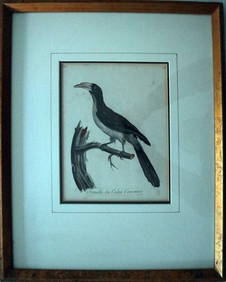
Le Valliant Crowned Hornbill Calao Couronne Rare Engraving ca1802 Framed OrnithologyLuis Porretta Fine Arts4.3(10)See Sold PriceMar 02, 2024
MAP - PIETER SCHENK / VALK / JANSSEN Hand Colored superb Map Central Italy c1702Luis Porretta Fine Arts4.3(10)See Sold PriceMar 02, 2024
CHARLES ROLLIN c1828 Ceasar Hand Colored Africa Military MapLuis Porretta Fine Arts4.3(10)See Sold PriceMar 02, 2024
PIETER SCHENK / VALK / JANSSEN Hand Colored Map of Rhodes Greece ca1702 vgcLuis Porretta Fine Arts4.3(10)See Sold PriceMar 02, 2024
Japanese Woodblock Print Hand Colored Sealed Cheery BlossomLuis Porretta Fine Arts4.3(10)See Sold PriceMar 02, 2024
Hand Colored Map of the city of Amsterdam 1720Global Auctions Company4.3(36)See Sold PriceMar 03, 2024
17th Century Hand Colored Engraved Map of GermanyGlobal Auctions Company4.3(36)See Sold PriceMar 03, 2024
18th Century Hess Germany Hand colored Engraved MapGlobal Auctions Company4.3(36)See Sold PriceMar 03, 2024
[MAPS]. DUFOUR, Auguste-Henri (1795-1865). Bound Volume of ...Potter & Potter Auctions4.6(539)See Sold PriceMar 07, 2024
Johann Homann Hand-Colored Map Engraving, c. 1730Auctions at Showplace4.5(726)See Sold PriceMar 17, 2024
Hand Colored Engraved Map of Europe, Jean Baptiste Bourguignon Anville 1754Global Auctions Company4.3(36)See Sold PriceMar 03, 2024
Mitchell - Map of the City of Washington (Washington, DC)Trillium Antique Prints & Rare Books4.5(30)See Sold PriceFeb 24, 2024
Kipling's Les plus beaux contes - 24 Engravings by Kees Van DongenTrillium Antique Prints & Rare Books4.5(30)See Sold PriceFeb 24, 2024
Pascal's Collection de fleurs... - Volume with 48 Originally Hand-colored LithographsTrillium Antique Prints & Rare Books4.5(30)See Sold PriceFeb 24, 2024


![[Maps]. Jean Baptiste Nolin. Collection of Four (1 of 1)](https://p1.liveauctioneers.com/906/86613/44530529_1_x.jpg?height=282&quality=70&version=1458833675)
![[Maps]. Jean Baptiste Nolin. Collection of Four (1 of 1)](https://p1.liveauctioneers.com/906/80657/41935123_1_x.jpg?height=282&quality=70&version=1445283342)


![[MAPS]. DUFOUR, Auguste-Henri (1795-1865). Bound Volume of ... (1 of 2)](https://p1.liveauctioneers.com/928/318880/171361279_1_x.jpg?height=282&quality=70&version=1707501302)


