ATLAS of ANTIENT GEOGRAPHY by SAMUEL BUTLER 1843John McInnis Auctioneers,LLC4.6(504)See Sold PriceFeb 24, 2024
18TH C. ANTIQUE MAP: FRENCH & INDIAN WAR, FRAMEDThomaston Place Auction Galleries4.4(389)See Sold PriceFeb 24, 2024
Rand McNally Railroad Map Cabinet w/ 21 Railroad MapsRail & Road Auctions4.6(165)See Sold PriceMar 08, 2024
Keith Haring - Ink on New York Map, Best Buddies, Inscribed, Signed, and DatedSapphire Auction Gallery4.1(67)See Sold PriceMar 02, 2024
LATE 17TH C. FRENCH MAP OF THE NEW WORLD BY ALEXIS-HUBERT JAILLOT (1632-1712)Thomaston Place Auction Galleries4.4(389)See Sold PriceFeb 24, 2024
Central Railroad of New Jersey Map of Sandy Hook Route-ca. 1903JM Hobby Supply and Railroad Artifact Auctions4.4(126)See Sold PriceFeb 24, 2024
Lot of Six Mixed Atlas Box Cars-HO Scale-New in BoxJM Hobby Supply and Railroad Artifact Auctions4.4(126)See Sold PriceFeb 25, 2024
Rand McNally/Santa Fe Railroad Map of Iowa-1912JM Hobby Supply and Railroad Artifact Auctions4.4(126)See Sold PriceFeb 24, 2024
NICOLAES VISSCHER (NETHERLANDS, 1618-1709) MAP OF THE NEW WORLDThomaston Place Auction Galleries4.4(389)See Sold PriceFeb 24, 2024
17TH C. WORLD MAP BY NICOLAES VISSCHER (NETHERLANDS, 1618-1709)Thomaston Place Auction Galleries4.4(389)See Sold PriceFeb 24, 2024
Lot of Six Mixed Atlas Cabooses-HO Scale-New in BoxJM Hobby Supply and Railroad Artifact Auctions4.4(126)See Sold PriceFeb 25, 2024
Philips' Smaller School Room Map of AsiaMap: Philips' Smaller School Room Map of Asia Date: 1961 ca. Cartographer: PHILIP, GEORGE Publisher: GEORGE PHILIP & SON LTD. Size (inches): 32.25X42 Polar projected folding wall map with brass hanginSee Sold Price
Philips' Smaller School Room Map of AsiaTitle/Content of Map: Philips' Smaller School Room Map of Asia Cartographer: PHILIP, GEORGE Size: 32.25X42 Polar projected folding wall map with brass hanging grommets. Distributed in the U.S. by DenoSee Sold Price
Philips' School room Map of GhanaTitle/Content of Map: Philips' School room Map of Ghana Date: ©1960 Publisher: Philips Size: 34Height - 25Width Reserve: $165.00 Shipping: Domestic: Flat-rate of $40.00 to anywhere within the contiguSee Sold Price
Philips' Comparative Series of Smaller School MapsTitle: Philips' Comparative Series of Smaller School Maps Scotland Physical & PoliticalPhilips Publisher: Size: 66 X 52 Best map of Scotland we have seen for showing the rift from Murray Firth throughSee Sold Price
Philips' Comparative Series of Smaller School MapsTitle: Philips' Comparative Series of Smaller School Maps Ireland Physical & Political Cartographer: Publisher: GEORGE PHILIP & SON Brief Description: Attractive and informative 3' x 4' wall map of IrSee Sold Price
Philips' Comparative Series of Smaller School MapsTitle: Philips' Comparative Series of Smaller School Maps Ireland Physical & Political Publication Date: c1925 Cartographer: Publisher: GEORGE PHILIP & SON Brief Description: Attractive and informativSee Sold Price
SoldAsia [With Europe]Title: Asia [With Europe] Publication Date: c1960 Cartographer: A.J. Nystrom & Co. Publisher:A.J. Nystrom & Co. Size: 050.0"Height - Width Markable surface schoolroom map showing land masses but nothiSee Sold Price
Ranally Physical-Political AsiaTitle/Content of Map: Ranally Physical-Political Asia Date: 1935 Cartographer: RAND MCNALLY & COMPANY Size: 51Height - 38.5Width Publisher: RAND MCNALLY & COMPANY Schoolroom map dissected and suspendeSee Sold Price
Asia. Lambert's Azimuthal Equal-Area Projction...Title/Content of Map: Asia. Lambert's Azimuthal Equal-Area Projction... Cartographer: RAISZ, ERWIN Date: 1960 Publisher: MODERN SCHOOL SUPPLY COMPANY, INC. Size: 51Height - 42.5Width Schoolroom wall mSee Sold Price
Asia. Lambert's Azimuthal Equal-Area Projction...Title: Asia. Lambert's Azimuthal Equal-Area Projction... Publication Date: 1960 Cartographer: RAISZ, ERWIN Publisher:MODERN SCHOOL SUPPLY COMPANY, INC. Size: 51Height - 42.5Width Schoolroom wall map mSee Sold Price
Cram's Superior Series. Physical-Political Asia.Title: Cram's Superior Series. Physical-Political Asia. Publication Date: c1930 Cartographer: CRAM, GEORGE F. & CO. Publisher:THE GEORGE F. CRAM COMPANY Size: 37Height - 48.75Width Schoolroom wall mapSee Sold Price
Cram's Superior Series. Cram's Asia.Title: Cram's Superior Series. Cram's Asia. Publication Date: 1950 Cartographer: CRAM, GEORGE F. CO. Publisher:THE GEORGE F. CRAM COMPANY Size: 40.75Height - 48.75Width Schoolroom wall map on spring rSee Sold Price
Cram's Superior Series. Physical-Political Asia.Title/Content of Map: Cram's Superior Series. Physical-Political Asia. Cartographer: CRAM, GEORGE F. & CO. Date: c1930 Publisher: THE GEORGE F. CRAM COMPANY Size: 37Height - 48.75Width Schoolroom wallSee Sold Price
(2) HAND DRAWN MAPS OF EUROPE & ASIA CIRCA 1849In amazingly minute detail. Inscribed Hannah M. Pearson verso "School and Family Geography" No. 11 and No. 14. after Mitchell's. 8 1/2 x 10 1/2 inches framed 14 1/2 x 16 1/2 inches (and smaller)See Sold Price
Sold1843 UNITED STATES SCHOOL ROOM MAP BY MITCHELL"Mitchell's National Map of the American Republic or United States of America; Together with Maps of the Vicinities of Thirty-Two of the Principal Cities and Towns in the Union". Hand colored lithograSee Sold Price
SoldGillette's Map of Madison Co. New York Large HangGillette's Map of Madison Co. New York Large Hanging School Room Map. Dated 1859. 5'4"h x 5'wSee Sold Price
Europe. American Geographers SeriesPublication Date: c1933 Title: Europe. American Geographers Series Cartographer: PARKINS, A. F./W. M. GREGORY/MARK JEFFERSON, et al. Publisher: A.J. Nystrom & Co. Height: 50 Width: 60 School room mapSee Sold Price
SoldGroup of three mid 20th Century Steiff animal toysGroup of three mid 20th Century Steiff animal toys together with a Continental porcelain figure (a/f), an atlas of the British Isles (a/f) and a large school room mapSee Sold Price
Three Printed Wall Maps, second quarter 20th centuThree Printed Wall Maps, second quarter 20th century, Bacon's Excelsior Map of the United States, for J.L. Hammett Co. and Map of the World, and George Philip School Room Map of Europe</See Sold Price
W. Hemisphere. Andrews' New Series School MapsTitle/Content of Map: W. Hemisphere. Andrews' New Series School Maps Cartographer: ANDREWS, A. H. Date: c1915 Publisher: THE A.H. ANDREWS COMPANY Size: 39.5Height - 39.5Width Schoolroom map mounted onSee Sold Price
Vintage School Map of AsiaUniversal Series, published by Rand McNally. Measures 40 1/4 x 50 1/4.See Sold Price
Map of AsiaMap of Asia ca. 1940 paper/linen/wood/metal 48.13" W x 4" D x 4" H Vintage school map of Asia published by Denoyer-Geppert Co. of Chicago, IL. Map has working pull down mechanism. Please note that thiSee Sold Price
1630 Mercator Map of Asia -- AsiaTitle: 1630 Mercator Map of Asia -- Asia Cartographer: G Mercator Year / Place: 1630, Amsterdam Map Dimension (in.): 7.3 X 10 in. This is an excellent smaller map of Asia. This map still show many mytSee Sold Price
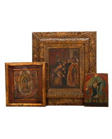
18TH C. DUTCH PAINTED OAK LETTER BOXThomaston Place Auction Galleries4.4(389)See Sold PriceFeb 24, 2024
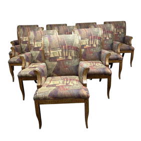
Set of 10 Contemporary Armed Dining ChairsPremier Auction Galleries4.3(329)See Sold PriceMar 09, 2024
Spanish school of the XIX century. After DIEGO DE VEL?ZQUEZ (Seville, 1599 - Madrid, 1660). DetailSetdart Auction House4(23)See Sold PriceFeb 28, 2024
Large Antique American Modernist Interior Scene Ashcan School Bar Room Original Oil PaintingCurated Gallery Auctions4.6(128)See Sold PriceFeb 25, 2024
Portfolio of 15 County Maps by Robert Morden (English 1650-1703)Nadeau's Auction Gallery4.7(405)See Sold PriceFeb 24, 2024
1818 RARE Geography Made Easy MAPS Jedidiah Morse Boston Indians Atlas AsiaSchilb Antiquarian Rare Books4.8(422)See Sold PriceMar 31, 2024
1849 Mitchell School ATLAS 24 MAPS America Holy Land France Africa Egypt AsiaSchilb Antiquarian Rare Books4.8(422)See Sold PriceMar 31, 2024
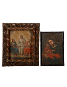
Three Mexican Retablos, Our Lady of Guadalupe.Turner Auctions + Appraisals4.3(313)See Sold PriceFeb 24, 2024
Two Mexican Retablos of Our Lady of Guadalupe.Turner Auctions + Appraisals4.3(313)See Sold PriceFeb 24, 2024
Carey, pub. 1796 - Map of KentuckyTrillium Antique Prints & Rare Books4.5(30)See Sold PriceFeb 24, 2024
Carey, pub. 1796 - Map of the Tennassee State formerly part of North Carolina (Tennessee)Trillium Antique Prints & Rare Books4.5(30)See Sold PriceFeb 24, 2024
De Jode, Rare, pub. 1593 - Map of the Middle East, Eastern Asia (Primae Partis Asiae accurataTrillium Antique Prints & Rare Books4.5(30)See Sold PriceFeb 24, 2024
Mid-Century Modern Folding Rattan Room Divider Screen, Sunburst, 1 of 2PUBLIC SALE4.7(225)See Sold PriceMar 02, 2024
Framed Space Age Rand McNally Map of Planets Poster, 1958PUBLIC SALE4.7(225)See Sold PriceMar 02, 2024


![Asia [With Europe] (1 of 6)](https://p1.liveauctioneers.com/5584/161711/81649448_1_x.jpg?height=282&quality=70&version=1582126150)