Marc Chagall-Limited Edition -Paris Opera Ceiling after ChagallArt Legacy Auctions4.5(225)See Sold PriceFeb 24, 2024
Salvador Dali Pantagruel Limited Edition Lithograph Hand signed and numberedArt Legacy Auctions4.5(225)See Sold PriceFeb 24, 2024
Pablo Picasso Bouquet of Peace Collection Domaine Picasso Limited Edition on paper.Art Legacy Auctions4.5(225)See Sold PriceFeb 24, 2024
A RARE MAXFIELD PARRISH JACK AND THE BEANSTALK PRINTSoulis Auctions4.8(958)See Sold PriceFeb 24, 2024
LARGE MECHANICAL PRINT 'STARS' AFTER MAXFIELD PARRISHSoulis Auctions4.8(958)See Sold PriceFeb 24, 2024
Heinrich Aldegrever, etc. 15 old master prints. 16th-17th centuries. Aldegrever works include "ManTremont Auctions4.5(298)See Sold PriceFeb 25, 2024
SoldPhilip, George C1900 Physical Hemisphere MapShowing Ocean Currents, Vegetation. Lithograph Map Published C1900, London for "Philips' New Handy General Atlas of the World" by George Philip. Paper Size: 21 x 14.5 inch (53 x 37cm) Good ConditionSee Sold Price
SoldPhilip, George C1900 Mixed Lot of 8 MapsIncl France, Holland/Belgium, East Indian Archipelago, China/Japan, Africa Physical, Mexico, West Indies/Central America, and South America Physical. Lithograph Maps Published C1900, London for "PhiliSee Sold Price
SoldPhilip, George C1900 Mixed Lot of 8 MapsIncl Asiatic Russia, Asia-Physical, France - North, France - Physical, Mediterranean, North Atlantic, Commercial Chart of the World, and Climatological. Lithograph Maps Published C1900, London for "PhSee Sold Price
SoldPhilip, George C1900 Celestial Astronomy MapLithograph Map Published C1900, London for "Philips' New Handy General Atlas of the World" by George Philip. Paper Size: 14.5 x 10.5 inch (37 x 27cm) Good ConditionSee Sold Price
SoldPhilip, George C1900 Lot 5 Maps. Australia, NZ PacificLithograph Maps Published C1900, London for "Philips' New Handy General Atlas of the World" by George Philip. Paper Size: 14.5 x 10.5 inch (37 x 27cm) Good ConditionSee Sold Price
SoldPhilip, George C1900 Lot of 7 Maps of UK & IrelandLithograph Maps Published C1900, London for "Philips' New Handy General Atlas of the World" by George Philip. Paper Size: 14.5 x 10.5 inch (37 x 27cm) Good ConditionSee Sold Price
SoldPhilip, George C1900 Lot of 5 Maps of AfricaIncl Northern Africa, Egypt and the Valley of the Nile, Central Africa, Africa and South of the Zambesi, and South Africa. Lithograph Maps Published C1900, London for "Philips' New Handy General AtlasSee Sold Price
SoldPhilip, George C1900 Lot of 4 Maps of CanadaLithograph Maps Published C1900, London for "Philips' New Handy General Atlas of the World" by George Philip. Paper Size: 14.5 x 10.5 inch (37 x 27cm) Good ConditionSee Sold Price
SoldPhilip, George C1900 Lot of 4 Maps of the USALithograph Maps Published C1900, London for "Philips' New Handy General Atlas of the World" by George Philip. Paper Size: 14.5 x 10.5 inch (37 x 27cm) Good ConditionSee Sold Price
SoldPhilip (G. & Son) pub. Northern HemispherePhilip (George & Son) publishers. Northern Hemisphere,engraved spherical map with outline hand-colouring, diameter 500mm., repairs to horizontal fold, a few nicks to edges, [1856] § Weller (EdSee Sold Price
SoldPhilip (G & Son) Northern HemispherePhilip (George & Son) publishers. Northern Hemisphere,engraved spherical map with outline hand-colouring, diameter 500mm., repairs to horizontal fold, a few nicks to edges, [1856] § Weller (ESee Sold Price
SoldJigsaw. World - A mixed group of 3 jigsaw maps,including McLoughlin Bro's Dissected Map of the World, an incomplete double-hemisphere world map by George Philip & Son, and another puzzle box containing 4 maps, India, South Africa, Canada, and AustSee Sold Price
Philips' Comparative Series of Smaller School MapsTitle: Philips' Comparative Series of Smaller School Maps Ireland Physical & Political Cartographer: Publisher: GEORGE PHILIP & SON Brief Description: Attractive and informative 3' x 4' wall map of IrSee Sold Price
Sold1852 EASTERN HEMISPHERE MAP BY G. PHILIP & SONHand colored and engraved map of the eastern hemisphere by George Philip and Son, Liverpool. Matted, 22.5 x 20.5 inch sight size. Not examined outside wrapping, appears excellent.See Sold Price
Jigsaw. Philip (George, & Son) - England and Wales;2 ccolour-printed jigsaw maps, each c.300 x 225mm. and the reverse, both laminated or varnished, in original matching flat wooden boxes with sliding lids mounted with key maps, c.1900; with a later PhSee Sold Price
Sold(George & Son, publisher) Northern Hemisphere, ProPhilip (George & Son, publisher) Northern Hemisphere, Projected on the Plane of the Horizon of London, engraved map with outline colour, 1853; Eastern Hemisphere, engraved map with outline colSee Sold Price
Philips' Comparative Series of Smaller School MapsTitle: Philips' Comparative Series of Smaller School Maps Ireland Physical & Political Publication Date: c1925 Cartographer: Publisher: GEORGE PHILIP & SON Brief Description: Attractive and informativSee Sold Price
SoldAtlas - Hughes, William C1900 Clasical Atlas, 18 Maps"Philips' Handy Classical Atlas" by William Hughes. London: George Philip & Son, nd C1900. 8vo (220 x 155m) Burgundy cloth, very slight wear. Complete with 18 Maps. A few with light pencil notes, oneSee Sold Price
SoldPhilip, George C1895 Maps of Devon, Cornwall Dorset (3)Lithograph Maps Published C1895 by George Philip & Son, London for "Phillips' Atlas of the British Isles" Centre fold as issued. Paper Size: 14.5 x 10 inch (37 x 25cm) Closed centre fold split on CornSee Sold Price
Sold(HOLY LAND.) Bartholomew, John George. Topographical &(HOLY LAND.) Bartholomew, John George. Topographical & Physical Map of Palestine Compiled from The Palestine Exploration Fund Surveys and Other Authorities. Enormous chromolithographed map of Israel aSee Sold Price
SoldPhilips New Library Map of London and its Environs,Philips New Library Map of London and its Environs, folding map, George Philip & Son, London, The London Geographical Institute, 152cm x 117cm - Stock Ref:6678-1See Sold Price
SoldPhilip, George 1856 LG HCol Map. Martinico, DominicaLarge Folio Lithograph Map Published Published 1856 by George Philip, Liverpool for "Philips' Commercial Atlas of the World" Paper Size: 26 x 21 inch (66 x 53cm) Light horizontal bend in centre. NeatlSee Sold Price
SoldLondon.- Philip (George, & Son) Philip's New Map ofLondon.- Philip (George, & Son) Philip's New Map of London and It's Environs, from the New Ordnance Survey including the area under the jurisdiction of the Metropolitan Board of Works, showing from ChSee Sold Price
SoldGeorge Philip & Son, map block puzzle with 6 differentHeading: (Maps & Atlases) Author: Title: George Philip & Son Map Block Puzzle Place Published: London & Liverpool Publisher:George Philip & Son Date Published: No date Description:See Sold Price
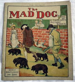
R. Caldecott & Dr. Goldsmith Elegy Death Mad Dog c1900 1st Edition IllustratedLuis Porretta Fine Arts4.3(10)See Sold PriceMar 02, 2024
SAMUEL FOOTE The Great Panjandrum c1900 Illustrated Children's Books 1st EditionLuis Porretta Fine Arts4.3(10)See Sold PriceMar 02, 2024
17TH C. WORLD MAP BY NICOLAES VISSCHER (NETHERLANDS, 1618-1709)Thomaston Place Auction Galleries4.4(394)See Sold PriceFeb 24, 2024
COVENS & MORTIER 1745 MAP OF THE GLOBEThomaston Place Auction Galleries4.4(394)See Sold PriceFeb 24, 2024
MAP OF SALZBURG BY GEORGE BRAUN & FRANS HOGENBURG. 1588Thomaston Place Auction Galleries4.4(394)See Sold PriceFeb 24, 2024
MATTHEWS c1856 Map Of Upper Canada Ontario Indian Land Agency Divisions Scarce!Luis Porretta Fine Arts4.3(10)See Sold PriceMar 02, 2024
Mary Blaize Elegy Glory Sex c1900 1st Edition IllustratedLuis Porretta Fine Arts4.3(10)See Sold PriceMar 02, 2024
Nova Totius Full Color Geographical World MapThe Benefit Shop Foundation Inc.4.3(3k)See Sold PriceFeb 28, 2024
[ENSLAVEMENT & ABOLITION]. 100 Dollars Reward! Ran Away from the service of Mr. George Ridenour, inFreeman's | Hindman4.4(1.6k)See Sold PriceFeb 27, 2024
GEORGE ANDREW CORLEY (DATES UNKNOWN) U.S. TEAM SKI TRYOUTS / MT. HOOD OREGON. 1939.Swann Auction Galleries4.4(71)See Sold PriceFeb 29, 2024
Cooke, George 1801 Antique Map. United States of AmericaAlbion Auctions4.7(341)See Sold PriceMar 01, 2024
Cooke, George 1801 Antique Map. West Indies CaribbeanAlbion Auctions4.7(341)See Sold PriceMar 01, 2024
Cooke, George 1801 Antique Map. Italy, Sicily, Sardinia & CorsicaAlbion Auctions4.7(341)See Sold PriceMar 01, 2024
C1900 Shadowbox Framed Hand Tinted Wedding Photo- Great Gilt Frame 28" X 24"George Cole Auctions4.6(396)See Sold PriceMar 02, 2024
C1900 Shadowbox Framed Hand Tinted Wedding Photo- Great Gilt Frame 28" X 24"George Cole Auctions4.6(396)See Sold PriceMar 02, 2024
C1900 Shadowbox Framed Hand Tinted Photo- Great Gilt Frame 24 1/2" X 20 1/2"George Cole Auctions4.6(396)See Sold PriceMar 02, 2024


![[ENSLAVEMENT & ABOLITION]. 100 Dollars Reward! Ran Away from the service of Mr. George Ridenour, in (1 of 1)](https://p1.liveauctioneers.com/197/319238/171468020_1_x.jpg?height=282&quality=70&version=1707520367)