ATLAS of ANTIENT GEOGRAPHY by SAMUEL BUTLER 1843John McInnis Auctioneers,LLC4.6(502)See Sold PriceFeb 24, 2024
18TH C. ANTIQUE MAP: FRENCH & INDIAN WAR, FRAMEDThomaston Place Auction Galleries4.4(386)See Sold PriceFeb 24, 2024
Rand McNally Railroad Map Cabinet w/ 21 Railroad MapsRail & Road Auctions4.6(165)See Sold PriceMar 08, 2024
Keith Haring - Ink on New York Map, Best Buddies, Inscribed, Signed, and DatedSapphire Auction Gallery4(67)See Sold PriceMar 02, 2024
LATE 17TH C. FRENCH MAP OF THE NEW WORLD BY ALEXIS-HUBERT JAILLOT (1632-1712)Thomaston Place Auction Galleries4.4(386)See Sold PriceFeb 24, 2024
Central Railroad of New Jersey Map of Sandy Hook Route-ca. 1903JM Hobby Supply and Railroad Artifact Auctions4.4(126)See Sold PriceFeb 24, 2024
Lot of Six Mixed Atlas Box Cars-HO Scale-New in BoxJM Hobby Supply and Railroad Artifact Auctions4.4(126)See Sold PriceFeb 25, 2024
Rand McNally/Santa Fe Railroad Map of Iowa-1912JM Hobby Supply and Railroad Artifact Auctions4.4(126)See Sold PriceFeb 24, 2024
NICOLAES VISSCHER (NETHERLANDS, 1618-1709) MAP OF THE NEW WORLDThomaston Place Auction Galleries4.4(386)See Sold PriceFeb 24, 2024
17TH C. WORLD MAP BY NICOLAES VISSCHER (NETHERLANDS, 1618-1709)Thomaston Place Auction Galleries4.4(386)See Sold PriceFeb 24, 2024
Lot of Six Mixed Atlas Cabooses-HO Scale-New in BoxJM Hobby Supply and Railroad Artifact Auctions4.4(126)See Sold PriceFeb 25, 2024
SoldPair Maps Of New England, George Willett 1821the northern and southern parts of New England, compiled for President Dwight's travels by George Gillet with Yale College as prime meridian, framed together. Light foxing, small creases, tear upper rSee Sold Price
SoldHistorical Pair of Maps Of New England by GeorgePair of Maps Of New England by George Gillett, Esq., published in 1821 | The maps depict the northern and southern parts of New England | Each map was compiled by George Gillet, Esq. for Yale CollegeSee Sold Price
TWO-PART MAP OF NEW ENGLANDboth by George Gillet, 1821, compiled for President Dwight's travels, including 'Map of the Northern Part of New England', 8-1/2 x 14 in. (sight), and 'Map of the Southern Part of New England', 11-1/2See Sold Price
TWO-PART MAP OF NEW ENGLANDTWO-PART MAP OF NEW ENGLANDboth by George Gillet, 1821, compiled for President Dwight's travels, including 'Map of the Northern Part of New England', 8-1/2 x 14 in. (sight), and 'Map of the Southern PSee Sold Price
TWO-PART MAP OF NEW ENGLANDboth by George Gillet, 1821, compiled for President Dwight's travels, including 'Map of the Northern Part of New England', 8-1/2 x 14 in. (sight), and 'Map of the Southern Part of New England', 11-1/2See Sold Price
SoldMap of the Southern Part of New EnglandDescription: The map of the Southern part of New England compiled for President Dwight’s travels by George Gillbert Esq. 1821. Shows Massachusetts, Rhode Island, Connecticut, Vermont, and New HampshSee Sold Price
Sold2 Silver Spoons Peter Anne &William BatemA pair of silver spoons. Sterling. 3.085 ozt (TROY OUNCES) Marked "PB AB Wb" - symbols Lion (Sterling), King (London), F and a George the 3rd bust. We believe the hallmark is from 1821 About 9" in lenSee Sold Price
Sold1823 Map of Southern New England, George Gillet1823 Dated map titled, "Map of the Southern Part of New England by George Gillet Esq. 1823". Strong plate impression and vibrant hand-coloring. Map framed under glass, measures: 17" H x 19" W, image:See Sold Price
Sold(Maps and Atlases, New England), Bromley, George W(Maps and Atlases, New England), Bromley, George W., and Bromley, Walter S., Atlas of the Town of Brookline, Philadelphia: G.W. Bromley and Co., 1893, cloth, folio, (rebacked, cloth worn, corners withSee Sold Price
SoldCollection of small New England Maps19th and 20th c New England maps from atlases and George Walker folding map of New HampshireSee Sold Price
SoldG. Woolworth Colton's Railroad Map. New England.[New England] Colton, George Woolworth (American, 1827-1901). "G. Woolworth Colton's Railroad, Township and Distance Map of New England with Adjacent Portions of New York, Canada and New Brunswick." GSee Sold Price
SoldButler, George 1874 Pair of Maps. Australia New ZealandLithograph Maps Published 1874, London for "The Public School Atlas of Modern Geography" by Rev. George Butler. Paper Size: 11 x 7 inch (28 x 17cm) Good ConditionSee Sold Price
Pair of New England Windsor chairsPair of New England Windsor chairs, blue paint. 38''h Provenance: George Schoellkopf, New York.See Sold Price
SoldGeorge T. Tribe(Massachusetts, late 19th/early 20th century), Pair watercolors, New England Coast: signed lower right "G.T. Tribe 1926", watercolor on paper laid on card, 4-3/16 x 9-3/4 in.; matching gilt wood frameSee Sold Price
Map of New England States - 1850'sMap Maine, New Hampshire, Vermont, Massachusetts, Rhode Island and Connecticut Cartographer: George Woolworth Colton Dated: C 1850's Type: Engraved Hand ColoredSee Sold Price
1873 Map of New EnglandAuthor: Bartholomew Title: 1873 Map of New England Medium: Ink on Paper Dimensions: 18"X14" Description: Map of New England dated 1873. Edited and by J.G. Bartholomew. Published by George Newnes in LoSee Sold Price
Bryce, James 1881 Pair of Maps of USA East Coast"Middle States. New York, Pennsylvannia, New Jersey, Delaware and Maryland" and "New England States. Maine, New Hampshire, Vermont, Massachusetts, Rhode Island and Connecticut" Lithograph Maps PublishSee Sold Price
Bryce, James 1881 Pair of Maps of USA East Coast"Middle States. New York, Pennsylvannia, New Jersey, Delaware and Maryland" and "New England States. Maine, New Hampshire, Vermont, Massachusetts, Rhode Island and Connecticut" Lithograph Maps PublishSee Sold Price
SoldPAIR 18TH C NEW ENGLAND/MASSACHUSETTS MAPSPair 18th century New England / Massachusetts maps. Includes "A Map of the Province of Massachusetts Bay, and Colony of Rhode Island, with part of Connecticut, New Hampshire, and Vermont." marked in lSee Sold Price
SoldPAIR OF TUFTED BROWN LEATHER CLUB CHAIRSWith rolled arms, turned front legs, and studded details. Both with dark brown leather with good patination. Made in New Castle, England, by George Smith Manufacturing Ltd. 20th C. H. 34 W. 35 1/2 D.See Sold Price
SoldBonner Map of Boston 1835 VersionJohn Bonner engraving on paper of the Town of Boston in New England, reproduced by George G Smith in 1835. The print features one of the earliest maps of Boston with a strong, clear plate mark. DimensSee Sold Price
SoldGeorge E. Shropshire (American, 20th cGeorge E. Shropshire (American, 20th c.) , a pair of paintings, "New England Countryside", oils on canvasboard, unsigned, 8 in. x 10 in., in matching period framesSee Sold Price
SoldNEW ENGLAND MAPS. Geo. W. Eldridge's Chart A Vineyard Sound and Nantucket Shoals. Boston: George...NEW ENGLAND MAPS. Geo. W. Eldridge's Chart A Vineyard Sound and Nantucket Shoals. Boston: George W. Eldridge, 1894. Engraved map on one sheet, framed, 28 1/4 x 48 1/2 in. sight. Signed by Eldridge. ToSee Sold Price
SoldAntique Map Of Southern New England 1823Map compiled by George Gillet for the travels of Yale College President Timothy Dwight, in 1823. Nice overall, with folds, creases, toning, and foxing. Not inspected out of frame.See Sold Price
Pr New England Bow Back Windsor SidechairsSchmidt's Antiques Inc. Since 19114.8(431)See Sold PriceMar 02, 2024
HOWARD HITCHMOUGH 18KT GOLD FOLDING KNIFE ENGRAVED BY TIM GEORGE England/Peterborough, NewEldred's4.7(409)See Sold PriceFeb 28, 2024
1849 THE NEW-ENGLAND MERCANTILE UNIONNorth American Artifact Auctions4.6(182)See Sold PriceApr 20, 2024
[MAP]. [ALBRIZZI, Giambatista, 1698-1777]. Carta Geografica...Potter & Potter Auctions4.6(539)See Sold PriceMar 07, 2024
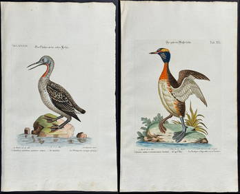
Edwards & Seligmann - Pair of Diver or Loon EngravingsTrillium Antique Prints & Rare Books4.5(30)See Sold PriceFeb 24, 2024
GEORGE GUSTAV ADOMEIT (1879-1967) "NEW ENGLAND LANDSCAPE".Amelia Jeffers, Auctioneers & Appraisers4.6(101)See Sold PriceMar 07, 2024
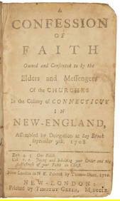
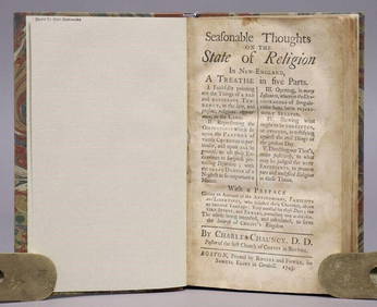
1743 SEASONABLE THOUGHTS ON STATE OF RELIGION IN NEW-ENGLAND antique AMERICANAJasper524.5(9.8k)See Sold PriceFeb 27, 2024
Pair of Pink New England Agata Ruffle Rim Glass Lamp ShadesMatthew Bullock Auctioneers4.7(1.8k)See Sold PriceMar 02, 2024
ANTIQUE AMERICANA, 1743: SEASONABLE THOUGHTS ON THE STATE OF RELIGION IN NEW ENGLANDNY Elizabeth 4.3(84)See Sold PriceMar 03, 2024


![[MAP]. [ALBRIZZI, Giambatista, 1698-1777]. Carta Geografica... (1 of 1)](https://p1.liveauctioneers.com/928/318880/171361280_1_x.jpg?height=282&quality=70&version=1707501302)