ATLAS of ANTIENT GEOGRAPHY by SAMUEL BUTLER 1843John McInnis Auctioneers,LLC4.5(505)See Sold PriceFeb 24, 2024
18TH C. ANTIQUE MAP: FRENCH & INDIAN WAR, FRAMEDThomaston Place Auction Galleries4.4(393)See Sold PriceFeb 24, 2024
Rand McNally Railroad Map Cabinet w/ 21 Railroad MapsRail & Road Auctions4.6(165)See Sold PriceMar 08, 2024
Keith Haring - Ink on New York Map, Best Buddies, Inscribed, Signed, and DatedSapphire Auction Gallery4(67)See Sold PriceMar 02, 2024
LATE 17TH C. FRENCH MAP OF THE NEW WORLD BY ALEXIS-HUBERT JAILLOT (1632-1712)Thomaston Place Auction Galleries4.4(393)See Sold PriceFeb 24, 2024
Central Railroad of New Jersey Map of Sandy Hook Route-ca. 1903JM Hobby Supply and Railroad Artifact Auctions4.4(127)See Sold PriceFeb 24, 2024
Lot of Six Mixed Atlas Box Cars-HO Scale-New in BoxJM Hobby Supply and Railroad Artifact Auctions4.4(127)See Sold PriceFeb 25, 2024
Rand McNally/Santa Fe Railroad Map of Iowa-1912JM Hobby Supply and Railroad Artifact Auctions4.4(127)See Sold PriceFeb 24, 2024
NICOLAES VISSCHER (NETHERLANDS, 1618-1709) MAP OF THE NEW WORLDThomaston Place Auction Galleries4.4(393)See Sold PriceFeb 24, 2024
17TH C. WORLD MAP BY NICOLAES VISSCHER (NETHERLANDS, 1618-1709)Thomaston Place Auction Galleries4.4(393)See Sold PriceFeb 24, 2024
Lot of Six Mixed Atlas Cabooses-HO Scale-New in BoxJM Hobby Supply and Railroad Artifact Auctions4.4(127)See Sold PriceFeb 25, 2024
SoldOVER 60 WW2 ORDNANCE SURVEY, BRITISH ARMY AND RAF MAPSA large group of over 60 assorted WW2-era Ordnance Survey, British Army and Royal Air Force maps of the United Kingdom and parts of Continental Europe. Most of the maps cover parts of the UK in detailSee Sold Price
WW2 British RAF map, covering the areas of LlandudnoWW2 British RAF map, covering the areas of Llandudno and Denby.See Sold Price
SoldSri Lanka.- Survey Department of Ceylon (publishers) 60Sri Lanka.- Survey Department of Ceylon (publishers) 60 Ordnance Survey maps of Sri Lanka, on a scale of one inch to one mile, lithographs printed in colours, the vast majority measure 580 x 760 mm. (See Sold Price
SoldMaps : A quantity of early to mid 20thC Ordnance SurveyMaps : A quantity of early to mid 20thC Ordnance Survey maps including British County maps for Gloucester, Middlesex etc., and for Ireland and America, Michelin French maps, a number of Air Force WarSee Sold Price
SoldMilitaria : An Ordnance Survey / Crown Copyright ' ArmyMilitaria : An Ordnance Survey / Crown Copyright ' Army Exercise Map , 1913 , Northern Sheet ' , covering the area between Coventry in the West , Rockingham in the North , Huntingdon in the East and WSee Sold Price
SoldMilitaria : An Ordnance Survey / Crown Copyright ' ArmyMilitaria : An Ordnance Survey / Crown Copyright ' Army Exercise Map , 1913 , Northern Sheet ' , covering the area between Coventry in the West , Rockingham in the North , Huntingdon in the East and WSee Sold Price
SoldMilitaria : An Ordnance Survey / Crown Copyright ' ArmyMilitaria : An Ordnance Survey / Crown Copyright ' Army Exercise Map , 1913 , Northern Sheet ' , covering the area between Coventry in the West , Rockingham in the North , Huntingdon in the East and WSee Sold Price
SoldBritish Isles.- Ordnance Survey MapsOrdnance Survey Maps,collection of ordnance survey maps, several linen-backed with illustrated covers, the majority of England and Wales, with c.15 of Scotland, and 2 of Ireland, comprising mSee Sold Price
SoldOrdnance Survey maps,West Coast of Scotland, late 19th century with some revisions, approx 60 sheets, some with vignettes, including Lochs, Western Isles, Skye, Harris, Hebrides etc, condition varies (c.60)See Sold Price
BRITISH MAPS OF ZEPPELIN ATTACKS ON ENGLAND (6)Fine selection of six printed maps issued in 1930 by a British 'Ordnance Survey', various sizes, most quarto, each showing the routes taken by German military zeppelins during attacks on England, andSee Sold Price
Sold1943 MAP OF NORTH WALES AND MANCHESTERBritish map titled, 'North Wales and Manchester - 2nd War Revision Air - Sheet 4'. Map is an Ordnance Survey of the UK made in 1943. 26.5 x 32 inches. Map has minor soiling and folds, otherwise good cSee Sold Price
SoldMaps : An quantity of Second World War Ordnance SurveyMaps : An quantity of Second World War Ordnance Survey maps of North Africa and the Middle East issued to the RAF. (8 maps) Please Note - we do not make reference to the condition of lots within catalSee Sold Price
1953 ORDNANCE SURVEY GEOLOGICAL MAP OF NORFOLK (84 X1953 ORDNANCE SURVEY GEOLOGICAL MAP OF NORFOLK (84 X 60)CM FRAMED AND GLAZEDSee Sold Price
SoldOrdnance Survey.- A group of 70 folding mapsOrdnance Survey.- A group of 70 folding maps,with various counties and areas of the British Isles, lithographed maps, many printed in colour, v.s., all folding into contemporary paper covers,See Sold Price
[world War One - Maps] WWI Military Maps of North West[world War One - Maps] WWI Military Maps of North West Europe, Belgium and France, Lot of 4 Belgium and Part of France. Edition 3. Scale 1:40,000. (British) Ordnance Survey November 1917. TopographicaSee Sold Price
SoldWW2 ECONOMY PLASTIC BRITISH ARMY CAP BADGESWW2 ECONOMY PLASTIC BRITISH ARMY CAP BADGES Lot of economy plastic WW2 issue cap badges including The Welch Regt (slides absent). REME, Signals, ATS, RAF, ATC, Pioneer.See Sold Price
Allied Advance 1918 - World War One MapAllied Advance 1918 - World War One World War I One. Linen backed. Map 9 - Ordnance Survey - Large Map with Scale Publisher British Dated: 1919 Type:See Sold Price
Third Battle of Ypres 1917 MapThird Battle of Ypres - Summer and Autumn 1917 World War I One. Linen backed. Map 4 - Ordnance Survey - Large Map with Scale Publisher British Dated: 1919<See Sold Price
Battle of Cambrai - Nov. Dec. 1917 MapBattle of Cambrai - November December 1917 World War I One. Linen backed. Map 5 - Ordnance Survey - Large Map with Scale Publisher British Dated: 1919See Sold Price
Final British Offensive August - November 1918 MapFinal British Offensive August to November 1918 World War I One. Linen backed. Map 8 - Ordnance Survey - Large Map with Scale Publisher British Dated: 1919See Sold Price
German Offensive On the Somme - March 1916 MapGerman Offensive On the Somme - March 1916 World War I One. Linen backed. Map 6 - Ordnance Survey - Large Map with Scale Publisher British Dated: 1919 TSee Sold Price
The Battle of Arras - Spring 1917 MapThe Battle of Arras - Spring 1917 World War I One. Linen backed. Map 3 - Ordnance Survey - Large Map with Scale Publisher British Dated: 1919 Type: CSee Sold Price
Battle of the Somme - 1916 MapBattle of the Somme - 1916 World War I One. Linen backed. Map 1 - Ordnance Survey - Large Map with Scale Publisher British Dated: 1919 Type: ColoredSee Sold Price
The German Offensive on the Lys - April 1918 MapThe German Offensive on the Lys - April 1918 World War I One. Linen backed. Map 7 - Ordnance Survey - Large Map with Scale Publisher British Dated: 1919See Sold Price
OFFER VAN ABRAHAM Book Of Genesis in Engravings c1700 Amsterdam Very rare!Luis Porretta Fine Arts4.3(10)See Sold PriceMar 02, 2024
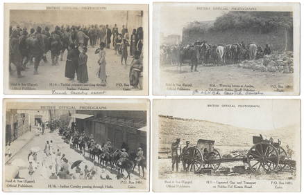
14 Official British Army Postcards - Palestine in WWILevy Auction House4.3(11)See Sold PriceFeb 27, 2024
Jerusalem Map for British Soldiers in Palestine - WW2Levy Auction House4.3(11)See Sold PriceFeb 27, 2024
Souvenir Silver Ring - The Conquest of Jerusalem, 1917Levy Auction House4.3(11)See Sold PriceFeb 27, 2024
Antisemitic Postcard - Churchill's Jewish Army - WW2Levy Auction House4.3(11)See Sold PriceFeb 27, 2024
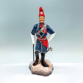
Michael Sutty Fine China Figurine, Colonel Walter FaneLion and Unicorn4.8(1.9k)See Sold PriceFeb 25, 2024
Vintage WW2 US Army Parachute Jump PatchThe Benefit Shop Foundation Inc.4.3(2.9k)See Sold PriceMar 06, 2024
WW2 US Army Flying Tiger Fighter Pilot Bomber Jacket (known pilot)Diamond Auctions LLC4.3(17)See Sold PriceFeb 29, 2024
Gideon Cohen Casein Painting Eliot House HarvardConcept Art Gallery4.7(510)See Sold PriceMar 06, 2024
ORIGINAL - WW2 ARMY 40th Infantry Battalion "Sunshine Division" YARD LONG PHOTOWestside Traders Emporium4.5(34)See Sold PriceFeb 27, 2024
INDIA WITHIN THE GANGES SUSAN GOLE ILLUSTRATED MAPS EARLY CARTOGRAPHYJasper524.5(9.9k)See Sold PriceFeb 27, 2024
WW2 WWII US Army Air Force Training Custom Reversible Air Crew HatEagles Corps International LLC4.5(107)See Sold PriceMar 10, 2024
Rare WW2 WWII Japanese Imperial Army M38 officers visor with boxEagles Corps International LLC4.5(107)See Sold PriceMar 10, 2024
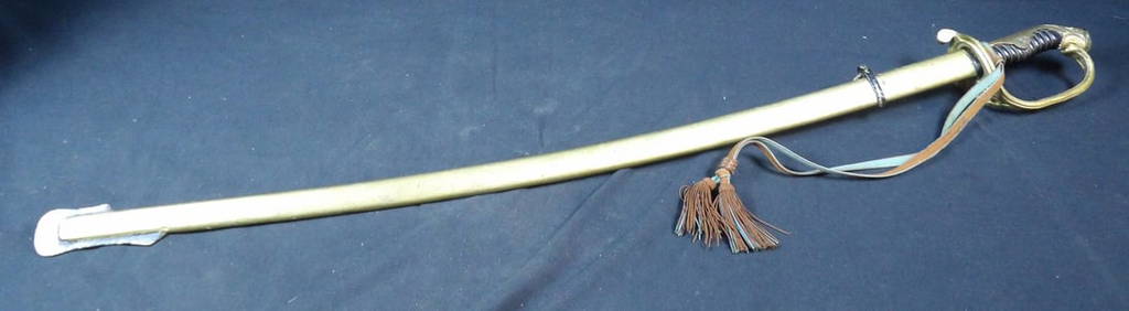
WW2 WWII Imperial Japanese army parade sword with cordEagles Corps International LLC4.5(107)See Sold PriceMar 10, 2024
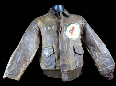
Incredible WW2 WWII 9th Army Air Force named and painted 305th Bomb Group A-2 JacketEagles Corps International LLC4.5(107)See Sold PriceMar 10, 2024
WW2 WWII German Army Officer's Infantry Visor with Gold Piping - CavalryEagles Corps International LLC4.5(107)See Sold PriceMar 10, 2024
WW2 WWII British made 8th Army Air Force Patch lotEagles Corps International LLC4.5(107)See Sold PriceMar 10, 2024
Stunning WW2 WWII Army Airways Communication Sytems Double Bullion patched Ike JacketEagles Corps International LLC4.5(107)See Sold PriceMar 10, 2024
WW2 WWII named German Army Medical Field Marshalls Generals Generallberstabsartz visorEagles Corps International LLC4.5(107)See Sold PriceMar 10, 2024
British Naive School Army Drummer Oil on BoardAuctions at Showplace4.6(740)See Sold PriceFeb 13, 2025


![[world War One - Maps] WWI Military Maps of North West (1 of 2)](https://p1.liveauctioneers.com/46/113409/58240769_1_x.jpg?height=282&quality=70&version=1512492316)