ATLAS of ANTIENT GEOGRAPHY by SAMUEL BUTLER 1843John McInnis Auctioneers,LLC4.6(502)See Sold PriceFeb 24, 2024
18TH C. ANTIQUE MAP: FRENCH & INDIAN WAR, FRAMEDThomaston Place Auction Galleries4.4(386)See Sold PriceFeb 24, 2024
Rand McNally Railroad Map Cabinet w/ 21 Railroad MapsRail & Road Auctions4.6(165)See Sold PriceMar 08, 2024
Keith Haring - Ink on New York Map, Best Buddies, Inscribed, Signed, and DatedSapphire Auction Gallery4(67)See Sold PriceMar 02, 2024
LATE 17TH C. FRENCH MAP OF THE NEW WORLD BY ALEXIS-HUBERT JAILLOT (1632-1712)Thomaston Place Auction Galleries4.4(386)See Sold PriceFeb 24, 2024
Central Railroad of New Jersey Map of Sandy Hook Route-ca. 1903JM Hobby Supply and Railroad Artifact Auctions4.4(126)See Sold PriceFeb 24, 2024
Lot of Six Mixed Atlas Box Cars-HO Scale-New in BoxJM Hobby Supply and Railroad Artifact Auctions4.4(126)See Sold PriceFeb 25, 2024
Rand McNally/Santa Fe Railroad Map of Iowa-1912JM Hobby Supply and Railroad Artifact Auctions4.4(126)See Sold PriceFeb 24, 2024
NICOLAES VISSCHER (NETHERLANDS, 1618-1709) MAP OF THE NEW WORLDThomaston Place Auction Galleries4.4(386)See Sold PriceFeb 24, 2024
17TH C. WORLD MAP BY NICOLAES VISSCHER (NETHERLANDS, 1618-1709)Thomaston Place Auction Galleries4.4(386)See Sold PriceFeb 24, 2024
Lot of Six Mixed Atlas Cabooses-HO Scale-New in BoxJM Hobby Supply and Railroad Artifact Auctions4.4(126)See Sold PriceFeb 25, 2024
SoldOriginal 1888 Butte City Mont. Territory Plat MapThis is an original plat map of Butte City, Montana Territory from 1888. The map shows what was once a bustling business district in Butte that included saloons, cigar stores, billiard halls, brewerieSee Sold Price
SoldButte City, Montana Pocket WatchAmerican Waltham Watch Co. 18 size, 14K gold, ser #3816103 (mfg. 1888) Lever set. Detail marked Hight & Fairfield - Butte City, Mont. Box case marked Warranted U.S. Assay '14K. Case engraved in floralSee Sold Price
1888 Montana Territory Stock - Volunteer Mining Company# 138 for 1000 shares to Mantel and Warren. Signed by William Clark and president WR Kenyon. Dateline Butte City, Montana Territory, September 5, 1888. Fancy scrollwork. Pristine condition with a fewSee Sold Price
Sold1880-1890 Montana Cabinet CardsThe lot features nine original 1880-1890 cabinet card original photography from Montana. These include such as: John Berkin Boulder, Mont., Weenink Dillon, Mont., Eliott Butte City, Aflower V Olson TrSee Sold Price
SoldGoldthwaite MAP NEW YORK CITY 1888 Hyde WelckeTitle: Map of the Steets and Avenues of New York City by: William M. Goldthwaite Publisher: Hyde & Company Printing Year: 1890 Details/Condition: Bound in its original textured cloth boards with gSee Sold Price
SoldThe Holiday Edition Butte Daily MinerPublished at Butte City Montana by the Miner Publishing Company. 1887-1888. Montana Territory. The only known volume of the sort. Owned by LO Leonard Anaconda Montana, Levi O Leonard owned the AnacondSee Sold Price
SoldJohnson's Atlas of the World Map of Wisconsin &Map: Original engraving from Johnson's Atlas of the World Date: 1868 Size: 18 inches high x 26 inches wide Map details cities, towns and territories. Please note that this lot has a reserve. When youSee Sold Price
SoldMap of Vermont & New Hampshire, 1868Original engraving from Johnson's Atlas of the World, 1868. Map details cities, towns and territories. Dimensions: 18" x 26". No Reserve This item ships from Ocean View, DE.See Sold Price
SoldMap of New Brunswick & Quebec, Dominion of Canada, 1868Original engraving from Johnson's Atlas of the World, 1868. Map details cities, towns and territories. Dimensions: 18" x 26". No Reserve This item ships from Ocean View, DE.See Sold Price
SoldMap of Europe, 1868Original engraving from Johnson's Atlas of the World, 1868. Map details cities, towns and territories. Dimensions: 18" x 26". No Reserve Buyer pays shipping - ships from Ocean View, DESee Sold Price
Map of Asia, 1868Original engraving from Johnson's Atlas of the World, 1868. Map details cities, towns and territories. Dimensions: 18" x 26". No Reserve Buyer pays shipping - ships from Ocean View, DESee Sold Price
SoldMap of Asia, 1868Original engraving from Johnson's Atlas of the World, 1868. Map details cities, towns and territories. Dimensions: 18" x 26". This item ships from Ocean View, DE.See Sold Price
SoldMap of South America, 1868Original engraving from Johnson's Atlas of the World, 1868. Map details cities, towns and territories. Dimensions: 18" x 26". This item ships from Ocean View, DE.See Sold Price
SoldMap of New Brunswick & Nova Scotia, Newfoundland,Original engraving from Johnson's Atlas of the World, 1868. Map details cities, towns and territories. Dimensions: 18" x 26". No Reserve This item ships from Ocean View, DE.See Sold Price
Map of Europe, 1868Original engraving from Johnson's Atlas of the World, 1868. Map details cities, towns and territories. Dimensions: 18" x 26". No Reserve This item ships from Ocean View, DE.See Sold Price
Map of Asia, 1868Original engraving from Johnson's Atlas of the World, 1868. Map details cities, towns and territories. Dimensions: 18" x 26". No Reserve This item ships from Ocean View, DE.See Sold Price
Map of Kentucky & Tennessee, 1868Original engraving from Johnson's Atlas of the World, 1868. Map details cities, towns and territories. Dimensions: 18" x 26". This item ships from Ocean View, DE.See Sold Price
Map of Georgia & Alabama, 1868Original engraving from Johnson's Atlas of the World, 1868. Map details cities, towns and territories. Dimensions: 18" x 26". This item ships from Ocean View, DE.See Sold Price
Map of Wisconsin & Michigan, 1868Original engraving from Johnson's Atlas of the World, 1868. Map details cities, towns and territories. Dimensions: 18" x 26". This item ships from Ocean View, DE.See Sold Price
Map of Ohio, 1868Original engraving from Johnson's Atlas of the World, 1868. Map details cities, towns and territories. Dimensions: 18" x 26". No Reserve Buyer pays shipping - ships from Ocean View, DESee Sold Price
Map of Vicinity of Richmond & Peninsular Campaign, 1868Original engraving from Johnson's Atlas of the World, 1868. Map details cities, towns and territories highlighting James, Chickahominy & York Rivers. Dimensions: 18" x 26". No Reserve This item shipsSee Sold Price
Map of Arkansas, Mississippi & Louisiana, 1868Original engraving from Johnson's Atlas of the World, 1868. Map details cities, towns and territories. Dimensions: 18" x 26". This item ships from Ocean View, DE.See Sold Price
Map of South America, 1868Original engraving from Johnson's Atlas of the World, 1868. Map details cities, towns and territories. Dimensions: 18" x 26". Shipping Domestic: Shipping rates are determind by destination. InternatioSee Sold Price
Map of Ohio, 1868Original engraving from Johnson's Atlas of the World, 1868. Map details cities, towns and territories. Dimensions: 18" x 26". No Reserve This item ships from Ocean View, DE.See Sold Price
Lake Superior and Mississippi River RR 1869 Seven Percent Bonds Book/Report-1869JM Hobby Supply and Railroad Artifact Auctions4.4(126)See Sold PriceFeb 24, 2024
Hammonds Map of Kentucky and Tennessee Railroads-1910JM Hobby Supply and Railroad Artifact Auctions4.4(126)See Sold PriceFeb 24, 2024
Kenyons Pocket Map and Shippers Guide of Wisconsin-1914JM Hobby Supply and Railroad Artifact Auctions4.4(126)See Sold PriceFeb 24, 2024
Rand McNally/Santa Fe Railroad Map of Iowa-1912JM Hobby Supply and Railroad Artifact Auctions4.4(126)See Sold PriceFeb 24, 2024
Lehigh Valley RR 1891 PassJM Hobby Supply and Railroad Artifact Auctions4.4(126)See Sold PriceFeb 24, 2024
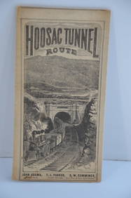
Fitchburg Railroad 1880 Hoosac Tunnel Route Public TimetableJM Hobby Supply and Railroad Artifact Auctions4.4(126)See Sold PriceFeb 24, 2024
OGILVY & BOWEN c1736 Original Map of Oxfordshire Berkshire Etc.Luis Porretta Fine Arts4.3(10)See Sold PriceMar 02, 2024
1888 Hand Book of the Pennsylvania Lines Containing Maps of Principal Cities - First EditionRail & Road Auctions4.6(165)See Sold PriceMar 07, 2024
Pair of The Gateway to a Continent Books - Grand Central Zone and 1939 World's FairRail & Road Auctions4.6(165)See Sold PriceMar 07, 2024
Keith Haring - Ink on New York Map, Best Buddies, Inscribed, Signed, and DatedSapphire Auction Gallery4(67)See Sold PriceMar 02, 2024
Francisco Zuniga 1912-1998 Flower Sellers PaintingHill Auction Gallery 4.7(1k)See Sold PriceFeb 28, 2024
JACKSON, Samuel L., ed. Jackson's International Almanac: A Pocket Encyclopedia of the Negro. [NewFreeman's | Hindman4.4(1.6k)See Sold PriceFeb 27, 2024
Strickler, Rare - San Francisco, CaliforniaTrillium Antique Prints & Rare Books4.5(30)See Sold PriceFeb 24, 2024
Vintage Street Map of Pittsburgh, Pennsylvania - Rand McNallyProverde Auctions4.3(3)See Sold PriceFeb 28, 2024