SoldOrbis Romani Pars Orientalis Map 1763Orbis Romani Pars Orientalis Map by cartographer Jean Babtiste Bourguignon 'Anville, original copperplate engaving dated 1763. Depicts Mediterranean Europe and Roman Empire. 12 1/2" H x 9 1/2" W. In gSee Sold Price
Collection of [9] ancient geographic maps. Asia, Holy* Orbis Romani Pars Orientalis. Large map, hand painted during the era of printing, includes Turkey, the Black Sea, the Holy Land and Egypt. 18th century. 55x70 cm. * Yabula Prima Gua Totius OrbSee Sold Price
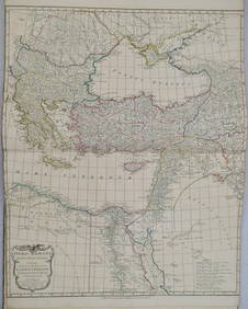
[ROMAN ORIENT]. D'Anville. Orbis Romani Pars[ROMAN ORIENT]. D'Anville. Orbis Romani Pars Orientalis. 1764. Double-page engraved map, outline color. 26 1/2 x 21 3/4. Fine condition. This is a live auction at our physical auction gallery, that yoSee Sold Price
Sold1764 d'Anville Map of Eastern Roman Empire from BlackTitle/Content of Map: 1764 d'Anville Map of Eastern Roman Empire from Black Sea Region to Middle East -- Orbis Romani Pars Orientalis Auspiciis Serenissimi Principis . . . MDCCLXIV Date: 1764, LondonSee Sold Price
1764 d'Anville Map of Eastern Roman Empire from BlackTitle/Content of Map: 1764 d'Anville Map of Eastern Roman Empire from Black Sea Region to Middle East -- Orbis Romani Pars Orientalis Auspiciis Serenissimi Principis . . . MDCCLXIV Date: 1764, LondonSee Sold Price
1764 d'Anville Map of Eastern Roman Empire from Black Sea Region to Middle East -- Orbis Romani ParsTitle: 1764 d'Anville Map of Eastern Roman Empire from Black Sea Region to Middle East -- Orbis Romani Pars Orientalis Auspiciis Serenissimi Principis . . . MDCCLXIV Cartographer: J d'Anville Year / PSee Sold Price
SoldOrbis Romani Pars OrientalisTitle: Orbis Romani Pars Orientalis Cartographer: D'Anville, J.B.B. Publication Date: 1764 Publisher: D'Anville Size: Height: 27 Width: 21.5 Map showing eastern Europe or Roman Empire. Details topograSee Sold Price
Orbis Romani Pars OrientalisPublication Date: 1764 Title: Orbis Romani Pars Orientalis Cartographer: D'Anville, J.B.B. Publisher: D'Anville Height: 27 Width: 21.5 Map showing eastern Europe or Roman Empire. Details topography, tSee Sold Price
Orbis Romani Pars OrientalisReserve Reduced! Title: Orbis Romani Pars Orientalis Date: 1764 Cartographer: D'Anville, J.B.B.Publisher: D'Anville Size (inches): 27X21.5 Map showing eastern Europe or Roman Empire. Details topographSee Sold Price
1764 d'Anville Map of Eastern Roman Empire from BlackTitle/Content of Map: 1764 d'Anville Map of Eastern Roman Empire from Black Sea Region to Middle East -- Orbis Romani Pars Orientalis Auspiciis Serenissimi Principis . . . MDCCLXIV Date: 1764, LondonSee Sold Price
Orbis Romani Pars OrientalisTitle/Content of Map: Orbis Romani Pars Orientalis Date Printed: 1764 Cartographer: D’Anville, J.B.B. Size: 27x21.5 Map showing eastern Europe or Roman Empire. Details topography, towns, etc. tSee Sold Price
Orbis Romani Pars OrientalisTitle/Content of Map: Orbis Romani Pars Orientalis Date Printed: 1764 Cartographer: D’Anville, J.B.B. Size: 27x21.5 Map showing eastern Europe or Roman Empire. Details topography, towns, etc. tSee Sold Price
Orbis Romani Pars OrientalisPublication Date: 1764 Title: Orbis Romani Pars Orientalis Cartographer: D'Anville, J.B.B. Publisher: D'Anville Height: 27 Width: 21.5 Map showing eastern Europe or Roman Empire. Details topography, tSee Sold Price
1764 d'Anville Map of Eastern Roman Empire from Black Sea Region to Middle East -- Orbis Romani ParsTitle: 1764 d'Anville Map of Eastern Roman Empire from Black Sea Region to Middle East -- Orbis Romani Pars Orientalis Auspiciis Serenissimi Principis . . . MDCCLXIV Cartographer: J d'Anville Year / PSee Sold Price
1764 d'Anville Map of Eastern Roman Empire from BlackTitle/Content of Map: 1764 d'Anville Map of Eastern Roman Empire from Black Sea Region to Middle East -- Orbis Romani Pars Orientalis Auspiciis Serenissimi Principis . . . MDCCLXIV Date: 1764, LondonSee Sold Price
(ROMAN EMPIRE.) d'Anville, Jean Baptiste Bourguignon.(ROMAN EMPIRE.) d'Anville, Jean Baptiste Bourguignon. Orbis Romani pars Occidentalis * Orbis Romani pars Orientalis. Together two double-page engraved sheets forming a map of the Mediterranean regionSee Sold Price
Sold1763 d'Anville Map of Western Roman Empire from Spain,Title/Content of Map: 1763 d'Anville Map of Western Roman Empire from Spain, England, Germany, Italy to Hungary to Africa -- Orbis Romani Pars Occidentalis Auspiciis Serenissimi Principis . . . MDCCLXSee Sold Price
1763 d'Anville Map of Western Roman Empire from Spain,Title/Content of Map: 1763 d'Anville Map of Western Roman Empire from Spain, England, Germany, Italy to Hungary to Africa -- Orbis Romani Pars Occidentalis Auspiciis Serenissimi Principis . . . MDCCLXSee Sold Price
1763 d'Anville Map of Western Roman Empire from Spain,Reserve Reduced! Title/Content of Map: 1763 d'Anville Map of Western Roman Empire from Spain, England, Germany, Italy to Hungary to Africa -- Orbis Romani Pars Occidentalis Auspiciis Serenissimi PrincSee Sold Price
1763 d'Anville Map of Western Roman Empire from Spain,Title/Content of Map: 1763 d'Anville Map of Western Roman Empire from Spain, England, Germany, Italy to Hungary to Africa -- Orbis Romani Pars Occidentalis Auspiciis Serenissimi Principis . . . MDCCLXSee Sold Price
1763 d'Anville Map of Western Roman Empire from Spain, England, Germany, Italy to Hungary to AfricaTitle: 1763 d'Anville Map of Western Roman Empire from Spain, England, Germany, Italy to Hungary to Africa -- Orbis Romani Pars Occidentalis Auspiciis Serenissimi Principis . . . MDCCLXIII CartographeSee Sold Price
1763 d'Anville Map of Western Roman Empire from Spain,Reserve Reduced! Map Title/Content: 1763 d'Anville Map of Western Roman Empire from Spain, England, Germany, Italy to Hungary to Africa -- Orbis Romani Pars Occidentalis Auspiciis Serenissimi PrincipiSee Sold Price
Sold[ROMAN OCCIDENT]. D'Anville. Orbis Romani Par[ROMAN OCCIDENT]. D'Anville. Orbis Romani Pars Occidentalis. 1763. Double-page engraved map, outline color. 26 1/2 x 21 1/2. Fine condition. Europe including Great Britain. This is a live auction at oSee Sold Price
SoldOribs Romani Pars Orientalis. 1794.[Ancient Geography/Mediterranean]. Oribs Romani Pars Orientalis. Double-page map of the eastern Mediterranean and Black Seas regions, from the 1764 by Jean Baptiste D’Anville. Lon: Laurie & Whittle,See Sold Price
17TH C. WORLD MAP BY NICOLAES VISSCHER (NETHERLANDS, 1618-1709)Thomaston Place Auction Galleries4.4(386)See Sold PriceFeb 24, 2024
LATE 17TH C. FRENCH MAP OF THE NEW WORLD BY ALEXIS-HUBERT JAILLOT (1632-1712)Thomaston Place Auction Galleries4.4(386)See Sold PriceFeb 24, 2024
WILLEM JANSZOON BLAEU (NETHERLANDS, 1571-1638) MAP OF UMBRIAThomaston Place Auction Galleries4.4(386)See Sold PriceFeb 24, 2024
MAP OF SALZBURG BY GEORGE BRAUN & FRANS HOGENBURG. 1588Thomaston Place Auction Galleries4.4(386)See Sold PriceFeb 24, 2024
1822 Rare Map by Ambroise Tardieu Napoleon Caldiero Battle of Vento 17" x 11Luis Porretta Fine Arts4.3(10)See Sold PriceMar 02, 2024
Vintage Full Color World Map LithographThe Benefit Shop Foundation Inc.4.3(2.9k)See Sold PriceFeb 28, 2024
Nova Totius Full Color Geographical World MapThe Benefit Shop Foundation Inc.4.3(2.9k)See Sold PriceFeb 28, 2024
De Jode, Rare, pub. 1593 - Map of Luxembourg (Lutzenburgii montuosissimi ac saltuosissimi ducatusTrillium Antique Prints & Rare Books4.5(30)See Sold PriceFeb 24, 2024
De Jode, Rare, pub. 1593 - Map of the British Isles [England, Scotland, Ireland] (Angliae Scotiae etTrillium Antique Prints & Rare Books4.5(30)See Sold PriceFeb 24, 2024
De Jode, Rare, pub. 1593 - Map of Italy (Italiae Totius Orbis olim Domatricis Nova ExactissTrillium Antique Prints & Rare Books4.5(30)See Sold PriceFeb 24, 2024
De Jode, Rare, pub. 1593 - Map of the Czech Republic or Kingdom of Bohemia (Chorographia insignisTrillium Antique Prints & Rare Books4.5(30)See Sold PriceFeb 24, 2024
De Jode, Rare, pub. 1593 - Map of the Middle East, Eastern Asia (Primae Partis Asiae accurataTrillium Antique Prints & Rare Books4.5(30)See Sold PriceFeb 24, 2024
De Jode, Rare, pub. 1593 - Map of Africa (Africae Vera Forma, et Situs)Trillium Antique Prints & Rare Books4.5(30)See Sold PriceFeb 24, 2024
1722 POMPONII MELA De Situ Orbis ARMORIAL VELLUM BINDING antiqueJasper524.5(9.8k)See Sold PriceFeb 27, 2024
New and Correct Map of North America With the West India Islands,Jasper524.5(9.8k)See Sold PriceFeb 27, 2024
1764 Bellin Map of Antigua -- Carte de l'Isle d'Antigue Situee par la Latitude 17 Degres et par laJasper524.5(9.8k)See Sold PriceFeb 27, 2024
Afrique…Nord-Ouest' & 'Inde' by Meissas. N Africa India Singapore 1861 old mapJasper524.5(9.8k)See Sold PriceFeb 28, 2024
ANTIQUE GEOMORPHOLOGY: 1782 POMPONII MELA DE SITU ORBIS ARMORIAL VELLUM BINDINGNY Elizabeth 4.3(84)See Sold PriceMar 03, 2024


![Collection of [9] ancient geographic maps. Asia, Holy (1 of 9)](https://p1.liveauctioneers.com/2398/98907/50388420_1_x.jpg?height=282&quality=70&version=1484078795)
![[ROMAN ORIENT]. D'Anville. Orbis Romani Pars (1 of 1)](https://p1.liveauctioneers.com/179/10971/2682763_1_x.jpg?height=282&quality=70&version=1162265652)


![[ROMAN OCCIDENT]. D'Anville. Orbis Romani Par (1 of 1)](https://p1.liveauctioneers.com/179/10971/2682762_1_x.jpg?height=282&quality=70&version=1162265652)


![De Jode, Rare, pub. 1593 - Map of the British Isles [England, Scotland, Ireland] (Angliae Scotiae et (1 of 2)](https://p1.liveauctioneers.com/6581/319571/171593327_1_x.jpg?height=282&quality=70&version=1707853304)


