ATLAS of ANTIENT GEOGRAPHY by SAMUEL BUTLER 1843John McInnis Auctioneers,LLC4.6(502)See Sold PriceFeb 24, 2024
18TH C. ANTIQUE MAP: FRENCH & INDIAN WAR, FRAMEDThomaston Place Auction Galleries4.4(386)See Sold PriceFeb 24, 2024
Rand McNally Railroad Map Cabinet w/ 21 Railroad MapsRail & Road Auctions4.6(165)See Sold PriceMar 08, 2024
Keith Haring - Ink on New York Map, Best Buddies, Inscribed, Signed, and DatedSapphire Auction Gallery4(67)See Sold PriceMar 02, 2024
LATE 17TH C. FRENCH MAP OF THE NEW WORLD BY ALEXIS-HUBERT JAILLOT (1632-1712)Thomaston Place Auction Galleries4.4(386)See Sold PriceFeb 24, 2024
Central Railroad of New Jersey Map of Sandy Hook Route-ca. 1903JM Hobby Supply and Railroad Artifact Auctions4.4(126)See Sold PriceFeb 24, 2024
Lot of Six Mixed Atlas Box Cars-HO Scale-New in BoxJM Hobby Supply and Railroad Artifact Auctions4.4(126)See Sold PriceFeb 25, 2024
Rand McNally/Santa Fe Railroad Map of Iowa-1912JM Hobby Supply and Railroad Artifact Auctions4.4(126)See Sold PriceFeb 24, 2024
NICOLAES VISSCHER (NETHERLANDS, 1618-1709) MAP OF THE NEW WORLDThomaston Place Auction Galleries4.4(386)See Sold PriceFeb 24, 2024
17TH C. WORLD MAP BY NICOLAES VISSCHER (NETHERLANDS, 1618-1709)Thomaston Place Auction Galleries4.4(386)See Sold PriceFeb 24, 2024
Lot of Six Mixed Atlas Cabooses-HO Scale-New in BoxJM Hobby Supply and Railroad Artifact Auctions4.4(126)See Sold PriceFeb 25, 2024
Northern Hemisphere. Arctic North Pole Greenland/N America joined FADEN 1802 mapTITLE/CONTENT OF MAP: 'Northern Hemisphere' DATE PRINTED: 1802 IMAGE SIZE: Approx 58.5 x 78.5cm, 23 x 30.75 inches (Large); Please note that this is a folding map. TYPE: Large antique atlas map, printSee Sold Price
Northern Hemisphere. Arctic North Pole Greenland/NTITLE/CONTENT OF MAP: 'Northern Hemisphere' The top image on the right hand side shows the entire map. To view a close up of the map showing the level of printed detail, please click on the bottom imaSee Sold Price
Northern Hemisphere. Arctic North Pole Greenland/NTITLE/CONTENT OF MAP: 'Northern Hemisphere' The top image on the right hand side shows the entire map. To view a close up of the map showing the level of printed detail, please click on the bottom imaSee Sold Price
Northern Hemisphere. Arctic North Pole Greenland/NTITLE/CONTENT OF MAP: 'Northern Hemisphere' The top image on the right hand side shows the entire map. To view a close up of the map showing the level of printed detail, please click on the bottom imaSee Sold Price
Sauthier Chorographical Map of New York 1779A Chorographical Map of the Province of New York in North America. Claude Joseph Sauthier (1736-1802). Fine engraved map on six sheets joined. London: William Faden, 1779. 73 3/4 x 56 1/2 inches sheetSee Sold Price
Northern hemisphere. Arctic Europe Asia Africa America. THOMSON 1817 old mapTITLE/CONTENT OF MAP: 'Northern hemisphere' DATE PRINTED: Published in 1817. Engraved on 12th August 1814; this date is marked on the map IMAGE SIZE: Approx 56.5 x 53.0cm, 22.25 x 20.75 inches (Large)See Sold Price
1714 Map of Northern HemisphereA View of the Northern Hemisphere from the North Pole 1714, "HEMISPHERE SEPTENTRIONAL LES TERRES ARCTIQUES..." by Guillaume Delisle, Paris, France, Choice Very Fine. Plate size 18.5" x 18.25"; overallSee Sold Price
"Northern hemisphere". Arctic Europe Asia AmericaTITLE/CONTENT OF MAP: 'Northern hemisphere'The top image on the right hand side shows the entire map. To view a close up of the map showing the level of printed detail, please click on the bottom imagSee Sold Price
"Northern hemisphere". Arctic Europe Asia AmericaTITLE/CONTENT OF MAP: 'Northern hemisphere' The top image on the right hand side shows the entire map. To view a close up of the map showing the level of printed detail, please click on the bottom imaSee Sold Price
Northern hemisphere. Arctic Europe Asia America Africa.TITLE/CONTENT OF MAP: 'Northern hemisphere' The top image on the right hand side shows the entire map. To view a close up of the map showing the level of printed detail, please click on the bottom imaSee Sold Price
SoldPolar-Karte Enthaltend: die Lander u. Meere vom NAuthor: Stieler, Adolph Description: Steel-engraved map, hand-colored in outline. 31.5x37.5 cm. (12½x14¾"). The northern half of the northern hemisphere, with the North Pole at the center. Plate 41bSee Sold Price
Sold1714 Map of Northern HemisphereMapsThe Northern Hemisphere Projected from the North Pole 1714, “HEMISPHERE SEPTENTRIONAL LES TERRES ARCTIQUES...” by Guillaume Delisle, Paris, France, Choice Very Fine. Plate size measuriSee Sold Price
Sold1714 Map of Northern HemisphereMapsThe Northern Hemisphere Projected from the North Pole 1714, “HEMISPHERE SEPTENTRIONAL LES TERRES ARCTIQUES...” by Guillaume Delisle, Paris, France, Choice Very Fine. Plate size measuriSee Sold Price
Sold1714 Map of Northern HemisphereMapsThe Northern Hemisphere Projected from the North Pole 1714, “HEMISPHERE SEPTENTRIONAL LES TERRES ARCTIQUES...” by Guillaume Delisle, Paris, France, Choice Very Fine. Plate size measuriSee Sold Price
Sold1714 Map of Northern Hemisphere"MapsThe Northern Hemisphere Projected from the North Pole 1714, “HEMISPHERE SEPTENTRIONAL LES TERRES ARCTIQUES...” by Guillaume Delisle, Paris, France, Choice Very Fine. Plate size measurSee Sold Price
Sold1714 Map of Northern HemisphereMapsThe Northern Hemisphere Projected from the North Pole 1714, “HEMISPHERE SEPTENTRIONAL LES TERRES ARCTIQUES...” by Guillaume Delisle, Paris, France, Choice Very Fine. Plate size measuriSee Sold Price
Sold1714 Map of Northern HemisphereMapsThe Northern Hemisphere Projected from the North Pole 1714, “HEMISPHERE SEPTENTRIONAL LES TERRES ARCTIQUES...” by Guillaume Delisle, Paris, France, Choice Very Fine. Plate size measuriSee Sold Price
SoldTwo Antique MapsMap of Northern Hemisphere: Carte Des Nouvelles Decouvertes Au Nord De La Mer Du Sud, 18" x 24 1/2" (sight) Francois Santini, Venice and Map Of North America: Nuove Scoperte De' Russi, 12" x 15 3/4" (See Sold Price
Sold[CANADA & NORTH AMERICA] A collection of 13 maps[CANADA & NORTH AMERICA] A collection of 13 engraved maps. Early 19th century. Various dimensions (approx. 30 x 25 cm). Various conditions. Includes: Northern Hemisphere, Illman & Pilbrow. New York. *See Sold Price
SoldJanvier (J) L'Amerique Septentrionale diviséeJanvier (Jean) L'Amerique Septentrionale diviséeMexico, the Caribbean islands, North America and the Arctic Circle, showing Greenland and Canada joined, engraved map with outline hand-colourinSee Sold Price
SoldJanvier. L'Amerique SeptentrionaleJanvier (Jean) L'Amerique Septentrionale diviséeMexico, the Caribbean islands, North America and the Arctic Circle, showing Greenland and Canada joined, engraved map with outline hand-colourinSee Sold Price
SoldMercator map of the North Pole c.1595Title: Septentrionalium Terrarum descriptio Author: Mercator, Gerard Description: Copper-engraved map, hand-colored. 36.2x38.7 (14¼x15¼").The first separate, printed map of the Arctic and northern CSee Sold Price
SoldSauthier - New-York in North AmericaClaude Joseph Sauthier (1736-1802), A Chorographical Map of the Province of New-York in North America, January 1, 1779, William Faden (1750-1836) publisher, black and white line engraving with periodSee Sold Price
Sold1714 Map of Northern HemisphereMapsNorthern Hemisphere Projected from the North Pole 1714, “HEMISPHERE SEPTENTRIONAL LES TERRES ARCTIQUES...” by Guillaume Delisle, Paris, France, Choice Very Fine. Plate size measuring aSee Sold Price
LARGE EARLY 18TH C. DUTCH CHART OF UPPER NORTH AMERICA, PIERRE MORTIER (1661-1711), FRAMEDThomaston Place Auction Galleries4.4(386)See Sold PriceFeb 24, 2024
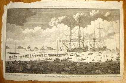
ALEXANDER HOGG ca1790 Engraving Captain Mulgrave Ships Ice Bound Cpt CookLuis Porretta Fine Arts4.3(10)See Sold PriceMar 02, 2024
[ARCTIC]. BOWEN, Emanuel. A New & Accurate Map of the North...Potter & Potter Auctions4.6(539)See Sold PriceMar 07, 2024
Arrowsmith & Lewis - Map of North AmericaTrillium Antique Prints & Rare Books4.5(30)See Sold PriceFeb 24, 2024
Arrowsmith & Lewis - Map of the United StatesTrillium Antique Prints & Rare Books4.5(30)See Sold PriceFeb 24, 2024
Mckenney & Hall - Two Octavo Volumes of Text with Rare Plate of Billy BowlegsTrillium Antique Prints & Rare Books4.5(30)See Sold PriceFeb 24, 2024
McKenney & Hall, Folio, Rare - 5 Native American LithographsTrillium Antique Prints & Rare Books4.5(30)See Sold PriceFeb 24, 2024
McKenney & Hall, Folio, Rare - Se-Quo-YahTrillium Antique Prints & Rare Books4.5(30)See Sold PriceFeb 24, 2024
McKenney & Hall, Folio, Rare - Hunting the BuffaloeTrillium Antique Prints & Rare Books4.5(30)See Sold PriceFeb 24, 2024
Audubon - 8 Quadruped LithographsTrillium Antique Prints & Rare Books4.5(30)See Sold PriceFeb 24, 2024
Audubon, Imperial Folio - American Cross Fox. 6Trillium Antique Prints & Rare Books4.5(30)See Sold PriceFeb 24, 2024
Audubon, Imperial Folio - Canada Lynx. 16Trillium Antique Prints & Rare Books4.5(30)See Sold PriceFeb 24, 2024
Karl Bodmer - A Young Mandan Indian. 24Trillium Antique Prints & Rare Books4.5(30)See Sold PriceFeb 24, 2024
Karl Bodmer - Scalp Dance of the Minatarres. 27Trillium Antique Prints & Rare Books4.5(30)See Sold PriceFeb 24, 2024
Map: An 18thC engraved and hand coloured map of North America and South America, titled DeClaydon Auctioneers Ltd4.3(125)See Sold PriceFeb 26, 2024
1822 MAP of NORTH & SOUTH AMERICA GEOGRAPHICAL STATISTICAL HISTORICAL antiqueJasper524.5(9.8k)See Sold PriceFeb 27, 2024
New and Correct Map of North America With the West India Islands,Jasper524.5(9.8k)See Sold PriceFeb 27, 2024
Map of United States of North America, 1785Antiques Online Auctions4.6(407)See Sold PriceMar 14, 2024


![[CANADA & NORTH AMERICA] A collection of 13 maps (1 of 2)](https://p1.liveauctioneers.com/1124/187577/94368854_1_x.jpg?height=282&quality=70&version=1607095126)


![[ARCTIC]. BOWEN, Emanuel. A New & Accurate Map of the North... (1 of 1)](https://p1.liveauctioneers.com/928/318880/171360917_1_x.jpg?height=282&quality=70&version=1707501302)


