ATLAS of ANTIENT GEOGRAPHY by SAMUEL BUTLER 1843John McInnis Auctioneers,LLC4.6(502)See Sold PriceFeb 24, 2024
18TH C. ANTIQUE MAP: FRENCH & INDIAN WAR, FRAMEDThomaston Place Auction Galleries4.4(386)See Sold PriceFeb 24, 2024
Rand McNally Railroad Map Cabinet w/ 21 Railroad MapsRail & Road Auctions4.6(165)See Sold PriceMar 08, 2024
Keith Haring - Ink on New York Map, Best Buddies, Inscribed, Signed, and DatedSapphire Auction Gallery4(67)See Sold PriceMar 02, 2024
LATE 17TH C. FRENCH MAP OF THE NEW WORLD BY ALEXIS-HUBERT JAILLOT (1632-1712)Thomaston Place Auction Galleries4.4(386)See Sold PriceFeb 24, 2024
Central Railroad of New Jersey Map of Sandy Hook Route-ca. 1903JM Hobby Supply and Railroad Artifact Auctions4.4(126)See Sold PriceFeb 24, 2024
Lot of Six Mixed Atlas Box Cars-HO Scale-New in BoxJM Hobby Supply and Railroad Artifact Auctions4.4(126)See Sold PriceFeb 25, 2024
Rand McNally/Santa Fe Railroad Map of Iowa-1912JM Hobby Supply and Railroad Artifact Auctions4.4(126)See Sold PriceFeb 24, 2024
NICOLAES VISSCHER (NETHERLANDS, 1618-1709) MAP OF THE NEW WORLDThomaston Place Auction Galleries4.4(386)See Sold PriceFeb 24, 2024
17TH C. WORLD MAP BY NICOLAES VISSCHER (NETHERLANDS, 1618-1709)Thomaston Place Auction Galleries4.4(386)See Sold PriceFeb 24, 2024
Lot of Six Mixed Atlas Cabooses-HO Scale-New in BoxJM Hobby Supply and Railroad Artifact Auctions4.4(126)See Sold PriceFeb 25, 2024
SoldNew Zealand.- Reid (John) Map of the Province of OtagoNew Zealand.- Reid (John) Map of the Province of Otago New Zealand, hanging lithographic wall map with hand-colouring, 1080 x 980 mm (42 1/2 x 38 1/2 in), laid on linen with original wooden support, sSee Sold Price
Reid (John, drawn by), Bibbs (T. F., lith.) & CollisReid (John, drawn by), Bibbs (T. F., lith.) & Collis (W., lith.) Map of the Province of Otago New Zealand, hanging lithographic wall map, laid on linen with original wooden support, scroll rod and tieSee Sold Price
SoldNEW ZEALAND. THE PROVINCE OF OTAGO.SCARCE PIECE IN WRAPS. 70 PAGES MAPS AND ILLUSTRATIONS. PUBLISHED IN NEW ZEALAND IN 1868.See Sold Price
SoldGroup of 4 mapsGroup of 4 maps 1). Johann Baptist Homanno- ''Ducatus Brabantiae Nova Tabula''; 2). John Cary- ''A New Map of United Provinces, Comprehending Holland, Zealand, Utrecht, Gelders, Over Yssel, FrieslandSee Sold Price
SoldAntique Hand Colored Paper Map: Low CountriesAntique Hand Colored Paper Map: Low CountriesAntique hand colored paper map; titled "A New Map of the United Provinces, Comprehending Holland, Zealand, Utrecht, Gelders ... " engraved by John Cary datSee Sold Price
SoldProvince of Maine from the best authorities, 1795.John Reid & W. Winterbotham. from the American Atlas. New York: J. Reid, L. Wayland & C. Smith, 1796. Engraved Map with Orignal Hand-color in Outline. 16 x 11 1/4 inchesSee Sold Price
SoldJohn Reid New Zealand cricket blazer, in black wool,John Reid New Zealand cricket blazer, in black wool, silver silkwork fern and inscribed N.Z., C.C. John Richard Reid CNZM OBE was born in Auckland 3rd June 1928 who captained New Zealand in 34 Test MaSee Sold Price
NEW ZEALAND provinces inc. Westland. Tavai PoenammooTITLE/CONTENT OF MAP: 'THE ISLANDS OF NEW ZEALAND.' The map shows the provinces of New Zealand including the short lived province of Westland which had been formed in 1873; New Zealand's provinces werSee Sold Price
SoldAmerica.- New York.- Montresor (John) A Map of theAmerica.- New York.- Montresor (John) A Map of the Province of New York, with Part of Pensilvania, and New England, wall map of New York to the east and west of the Hudson River Valley, including allSee Sold Price
SoldTallis map of New ZealandTitle: New Zealand Author: Tallis, John Description: Steel-engraved map, hand-colored in outline; 4 engraved vignettes. 30.5x22 cm. (12x8¾") plus decorative border.The islands of New Zealand, with viSee Sold Price
John Bartholomew: Map of New Zealand, 1898Map: New Zealand Maker: John Bartholomew From The Citizen's Atlas Date: 1898 Size: 14 x 18 inches Please note that this lot has a confidential reserve. When you leave a bid in advance of the auction,See Sold Price
SoldAustralasia.- New Zealand.- Craik (John Lillie) The NewAustralasia.- New Zealand.- [Craik (John Lillie)] The New Zealanders, reprint, map, illustrations, original green cloth, spine gilt and slightly faded, [1847] § West of England Board of the New ZSee Sold Price
Rare antique map from 1626 by John Speede. New Map ofRare antique map from 1626 by John Speede. New Map of XVII provinces low Germanie. Hand colored (discolored + small tear in middle fold). Size: 42 x 55 cm. In reasonable / good condition.See Sold Price
SoldTallis, John (Pub) 1852 Map. New ZealandSteel Engraved Map with Original Outline Hand Color Published 1852-56 by John Tallis, London for "The Universal Pronouncing Dictionary" by Thomas Wright. Drawn & Engraved by John Rapkin. Centre fold aSee Sold Price
SoldBartholomew, John 1922 Pair Maps. New Zealand & Pacific"New Zealand" and "Islands of Oceania" The latter showing Hawaii and other Pacific Islands. Large Lithograph Maps Published 1922 by The Times, London for "The Times Survey Atlas of the World" Maps bySee Sold Price
SoldCHILTON, Charles, editor. The Subantarctic Island ofCHILTON, Charles, editor. The Subantarctic Island of New Zealand. Wellington, New Zealand: John Mckay, 1909. 2 volumes, 4to. Numerous illustrations from drawings and photographs, large folding map inSee Sold Price
SoldRapkin, John 1860 Antique Map of New ZealandSteel Engraved Map Published 1860 by The London Printing & Published Company, London for "The Royal Dictionary-Cyclopedia for Universal Reference" by Thomas Wright. Drawn & Engraved by John Rapkin. FoSee Sold Price
SoldBartholomew, John 1922 Large Map of New ZealandLarge Lithograph Map Published 1922 by The Times, London for "The Times Survey Atlas of the World" Maps by John George Bartholomew of the Edinburgh Geographical Institute. Centre fold as issued. PaperSee Sold Price
SoldMONTRESOR, John. Map of the Province of New York,MONTRESOR, John. Map of the Province of New York, with Part of Pennsylvania, and New England...Map of the Province of New York, with Part of Pennsylvania, and New England, from an Actual SurveSee Sold Price
John Arrowsmith - Map of the Colony of New ZealandMap of the Colony of New Zealand from Official Documents, 1844, Hand coloured engraving, Inscribed, Provenance: Estate of Frederick and Evelyn Page, WellingtonSee Sold Price
1965 New Zealand Team to India, Pakistan and the UK,1965 New Zealand Team to India, Pakistan and the UK, official team sheet with 17 signatures including John Reid (captain), Graham Dowling & Bert Sutcliffe.See Sold Price
Sold2 EARLY MAPS BY JOHN SENEX-ARTOIS PROVINCE + NEW CASTLE2 EARLY MAPS BY JOHN SENEX- ARTOIS PROVINCE AND OLD AND NEW CASTLE APPROX. 19.5" X 25"See Sold Price
Rare map of Quebec 1776Heading: Author: Sayer, Robert and John Bennett Title: A New Map of the Province of Quebec, according to The Royal Proclamation, of the 7th of October 1763. from The French Surveys Connected with thoSee Sold Price
SoldRare map of Quebec 1776Heading: Author: Sayer, Robert and John Bennett Title: A New Map of the Province of Quebec, according to The Royal Proclamation, of the 7th of October 1763. from The French Surveys Connected with thoSee Sold Price
WESLEY REV. JOHN Sermons On Several Occasions c1854 Full Tree Calf Vol. IILuis Porretta Fine Arts4.3(10)See Sold PriceMar 02, 2024
ANTHONY D. (A.D.) BLAKE (New Zealand, 1951-), "The Flying Fish and John Gilpin Meet off Cape HornEldred's4.7(409)See Sold PriceFeb 27, 2024
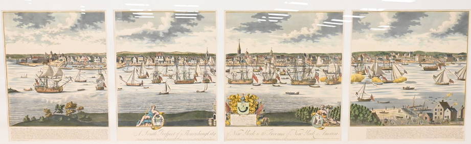
A South Prospect of Ye Flourishing City of New York in the Province of New York, North AmericaNadeau's Auction Gallery4.7(401)See Sold PriceFeb 24, 2024
17th Century Hand Colored Engraved Map of GermanyGlobal Auctions Company4.3(36)See Sold PriceMar 03, 2024
[CLIPPER SHIP CARD]. New Zealand Neal & Crown in Shield Aus...Potter & Potter Auctions4.6(539)See Sold PriceMar 07, 2024
D'Entrecasteaux - Map of Australia (New Holland), New Zealand, and southern Asia and surroundingTrillium Antique Prints & Rare Books4.5(30)See Sold PriceFeb 24, 2024
Map: A 19thC engraved and hand coloured map of Buckingham titled A New Map of BuckinghamshireClaydon Auctioneers Ltd4.3(125)See Sold PriceFeb 26, 2024
Clarke & Neele 1815 Map. Europe - Recent Political ChangesAlbion Auctions4.6(336)See Sold PriceMar 01, 2024
Guthrie, William 1812 Antique Map. Spain and PortugalAlbion Auctions4.6(336)See Sold PriceMar 01, 2024


![[CLIPPER SHIP CARD]. New Zealand Neal & Crown in Shield Aus... (1 of 2)](https://p1.liveauctioneers.com/928/318880/171360960_1_x.jpg?height=282&quality=70&version=1707501302)


