ATLAS of ANTIENT GEOGRAPHY by SAMUEL BUTLER 1843John McInnis Auctioneers,LLC4.6(502)See Sold PriceFeb 24, 2024
18TH C. ANTIQUE MAP: FRENCH & INDIAN WAR, FRAMEDThomaston Place Auction Galleries4.4(386)See Sold PriceFeb 24, 2024
Rand McNally Railroad Map Cabinet w/ 21 Railroad MapsRail & Road Auctions4.6(165)See Sold PriceMar 08, 2024
Keith Haring - Ink on New York Map, Best Buddies, Inscribed, Signed, and DatedSapphire Auction Gallery4(67)See Sold PriceMar 02, 2024
LATE 17TH C. FRENCH MAP OF THE NEW WORLD BY ALEXIS-HUBERT JAILLOT (1632-1712)Thomaston Place Auction Galleries4.4(386)See Sold PriceFeb 24, 2024
Central Railroad of New Jersey Map of Sandy Hook Route-ca. 1903JM Hobby Supply and Railroad Artifact Auctions4.4(126)See Sold PriceFeb 24, 2024
Lot of Six Mixed Atlas Box Cars-HO Scale-New in BoxJM Hobby Supply and Railroad Artifact Auctions4.4(126)See Sold PriceFeb 25, 2024
Rand McNally/Santa Fe Railroad Map of Iowa-1912JM Hobby Supply and Railroad Artifact Auctions4.4(126)See Sold PriceFeb 24, 2024
NICOLAES VISSCHER (NETHERLANDS, 1618-1709) MAP OF THE NEW WORLDThomaston Place Auction Galleries4.4(386)See Sold PriceFeb 24, 2024
17TH C. WORLD MAP BY NICOLAES VISSCHER (NETHERLANDS, 1618-1709)Thomaston Place Auction Galleries4.4(386)See Sold PriceFeb 24, 2024
Lot of Six Mixed Atlas Cabooses-HO Scale-New in BoxJM Hobby Supply and Railroad Artifact Auctions4.4(126)See Sold PriceFeb 25, 2024
SoldMitchell: Antique Map of New York to North CarolinaTitle/Content of Map: 1852 Mitchell Map of New York to North Carolina -- No. 11 Map of the Middle States and Part of Southern… Date Printed: 1852 Philadelphia Cartographer: S Mitchell / CowperthwaitSee Sold Price
Sold10 Maps: New York street grid, views, US, MD[New York/Maryland/US] 10 Maps. 8 1/8 x 9 3/4 in. to 17 7/8 x 27 1/2 in. Sold with all faults. ++ MAP OF THE CITY OF NEW-YORK 1852. Folding map from an annual edition of Valentine’s Manual. ++ PARTSee Sold Price
SoldMid-19th Century Map of Brooklyn during the RevolutionMap of Brooklyn at the time of the Revolutionary War. After Jeremiah Johnson (1766-1852). Lithographed map. New York: Geo. Hayward, 1858. 12 1/2 x 21 1/2 inches sheet. Revolutionary War Map drawn by tSee Sold Price
Sold[MAP] A PLAN OF THE CITY AND ENVIRONS OF NEW YORK[MAP] A PLAN OF THE CITY AND ENVIRONS OF NEW YORK Printed colored map. 29 1/2 x 25 1/4 inches. Framed. New York: Valentine's Manual, 1854See Sold Price
SoldClarke & Stephenson NEW YORK CITY GUIDE August 1862Details: CLARKE & STEPHENSON (publishers). Clarke & Stephenson's New York City Guide. For August, 1862. New York: French & Wheat, printers, 1862. Folding map, printed in blue, advertisements printedSee Sold Price
SoldNew England New York Railroad MapRailroad, Steam Boat & Stage Route of New England, New York, Canada, Antique Map by Shearman & Smith, 1852. 22 3/4" x 28".See Sold Price
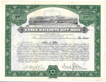
SoldMaps of the Holy Land - Eran Laor, 1986Maps of the Holy Land. Cartobibliography of Printed Maps, 1475-1900. New York-Amsterdam: Alan R. Liss; Meridien, 1986.English. Bibliography of about 1170 maps of Eretz Israel printed between the yearsSee Sold Price
SoldMap of MANHATTAN NEW YORK , Alexander Gross, GeographiaMap of MANHATTAN NEW YORK , Alexander Gross, Geographia Map Co. map is printed original on paper mounted to a large piece of glassSize: 89 x 189 inchesSee Sold Price
Tanner: Antique Map of New York, 1843Title/Content of Map: New York by Tanner Date Printed: 1843 Cartographer: based on the work of H.C. Tanner Material/Medium: Paper Size: 17" x 14" Hand colored engraved Map. From the first edition publSee Sold Price
SoldJohnson: Antique Map of New York, 1868Title/Content of Map: New York by Johnson Date Printed: 1868 Cartographer: A.J. Johnson Material/Medium: Paper Size: 18" x 24" Hand colored steel engraved Map. From Johnson's New Illustrated Family AtSee Sold Price
Sold[MAP] BURR, DAVID H. Map of the Counties of New Y[MAP] BURR, DAVID H. Map of the Counties of New York, Queens, Kings, and Richmond Printed map, partly colored. Framed, 20 1/2 x 25 1/2 inches. [New York City]: 1829See Sold Price
SoldMITCHELL, SAMUEL AUGUSTUS. Maps of Maine, NewMITCHELL, SAMUEL AUGUSTUS. Maps of Maine, New Hampshire and Vermont, Massachusetts & Rhode Island, Connecticut, New York, and New York City [cover title]. 6 lithographed maps, principally printed in oSee Sold Price
SoldNew York City ANTIQUE MAP 40th ST TO HARLEM 1842Details: This original antique pocket map printed in 1842 unfolds to display a section of New York City from 40th St. to Harlem.When opened, this map measures approximately 18â€x14â€.Please attSee Sold Price
Soldc.1780 Map of New York and ConnecticutMapsc.1780 Map of New York and Connecticut c.1780, “Map of Hudson’s River, With The Adjacent Country”, Choice Very Fine. This well preserved, 12.5” x 9.25” map, printed iSee Sold Price
SoldTanner: Antique Map of New York City, 1843Title/Content of Map: New York City by Tanner Date Printed: 1843 Cartographer: based on the work of H.C. Tanner Material/Medium: Paper Size: 17" x 14" Hand colored engraved Map. From the first editionSee Sold Price
SoldMitchell: Antique Map of New York City, 1869Title/Content of Map: New York City by Mitchell Date Printed: 1869 Cartographer: Augustus S. Mitchell Material/Medium: Paper Size: 23" x 15" Condition: Excellent Hand colored engraved Map. Published iSee Sold Price
SoldGroup of New York State Historical MapsGroup of New York State Historical Maps. Map of Orleans County, NY, 1852 (40" x 47"); Map of Village of Albion, NY, 1857 (40" x 47"); Map of the State of New York, 1833 (21" x 25 1/2").. The RochesterSee Sold Price
SoldTanner: Antique Map of New York, 1843Title/Content of Map: New York by Tanner Date Printed: 1843 Cartographer: H.C. Tanner Material/Medium: Paper Size: 17" x 14" Hand colored engraved Map based on the work of H.C. Tanner from the first eSee Sold Price
SoldMap of Bronx New York c 1994Map of Bronx New York c 1994. Framed in a gold toned metal frame, printed map on paper depicting Bronx New York, with the street names listed alphabetically below. Measures approx 40 in tall by 27 inSee Sold Price
SoldRand McNally: Antique City Plan of Brooklyn, NY, 1912Title/Content of Map: 'Main Portion Brooklyn ' Brooklyn town city map plan. New York. Date Printed: 1912 Image Size: Approx 27.5 x 33.5cm, 10.75 x 13 inches (Large) Type: Antique colour (color) city pSee Sold Price
SoldThree 19th Century Maps of New YorkGroup Lot of 3 New York Maps 1. Map of the City of New York, 1852. D. T. Valentine (1801 - 1869). New York: Hayward, 1852. Lithograph. Dimensions. 2. Plan of the City of New-York, drawn by Major HollaSee Sold Price
SoldNew York City Subway Travel1992Title/ Content of Map:New York City Subway Travel1992 Date Printed: 1992 Cartographer: Material/Medium: paper Dimensions: 15-fold. approx. 18.5x 22 inches open, 4x7.5 inches folded. Additional InformaSee Sold Price
SoldThree American Maps, pub. J.H. ColtonA Group of Three Antique American Maps, 1852-1854, published by J.H. Colton, No. 86 Cedar St., New York, comprised of "Chart of National Flags", "Map of North America", and "The World", 19 1/2 in. x 2See Sold Price
Sold3 VOLUME 2ND EDITION AUDUBON QUADRUPEDS OF NORTH A3 VOLUME 2ND EDITION AUDUBON QUADRUPEDS OF NORTH AMERICA: 3 Octavo volumes published 1852, 1854, and 1854 by V. G. Audubon New York, printed by R. Craighead, Printer and Stereotyper, New York. Hand coSee Sold Price
New York Central and Hudson River RR Public Timetable-November 3, 1901JM Hobby Supply and Railroad Artifact Auctions4.4(126)See Sold PriceFeb 24, 2024
Illustrated Sabbath Cloth - Holy Sites of Eretz IsraelLevy Auction House4.3(11)See Sold PriceFeb 27, 2024
1872 Holy BIBLE & Hitchcock Analysis Gruden Concordance Theology MAPS Holy LandSchilb Antiquarian Rare Books4.8(421)See Sold PriceMar 31, 2024
Keith Haring - Ink on New York Map, Best Buddies, Inscribed, Signed, and DatedSapphire Auction Gallery4(67)See Sold PriceMar 02, 2024
Johann Homann Hand-Colored Map Engraving, c. 1730Auctions at Showplace4.5(726)See Sold PriceMar 17, 2024
Audubon, NYSE Best Watercolor Ed - Pair: Brown Pelican & Reddish EgretTrillium Antique Prints & Rare Books4.5(30)See Sold PriceFeb 24, 2024
8PC New York Police Department Guide BooksBruneau & Co. Auctioneers4.5(491)See Sold PriceMar 18, 2024
Goddess in Yellow, Large ERTE Lithograph Poster, 1982Antique Kingdom4.1(21)See Sold PriceMar 08, 2024
James Rosenquist (American, 1933-2017) Lithograph in Colors on Wove Paper, 1970, "Silver Skies", HDuMouchelles4.6(825)See Sold PriceMar 15, 2024
Eric Fischl (American, B. 1948) Etching And Aquatint on Hahnemuhle Paper Ca. 1987, "Shower", H 15.5"DuMouchelles4.6(825)See Sold PriceMar 15, 2024


![[MAP] A PLAN OF THE CITY AND ENVIRONS OF NEW YORK (1 of 1)](https://p1.liveauctioneers.com/292/2831/1224722_1_x.jpg?height=282&quality=70)


![[MAP] BURR, DAVID H. Map of the Counties of New Y (1 of 1)](https://p1.liveauctioneers.com/292/8142/1390872_1_x.jpg?height=282&quality=70)