ATLAS of ANTIENT GEOGRAPHY by SAMUEL BUTLER 1843John McInnis Auctioneers,LLC4.5(505)See Sold PriceFeb 24, 2024
18TH C. ANTIQUE MAP: FRENCH & INDIAN WAR, FRAMEDThomaston Place Auction Galleries4.4(393)See Sold PriceFeb 24, 2024
Rand McNally Railroad Map Cabinet w/ 21 Railroad MapsRail & Road Auctions4.6(165)See Sold PriceMar 08, 2024
Keith Haring - Ink on New York Map, Best Buddies, Inscribed, Signed, and DatedSapphire Auction Gallery4.1(67)See Sold PriceMar 02, 2024
LATE 17TH C. FRENCH MAP OF THE NEW WORLD BY ALEXIS-HUBERT JAILLOT (1632-1712)Thomaston Place Auction Galleries4.4(393)See Sold PriceFeb 24, 2024
Central Railroad of New Jersey Map of Sandy Hook Route-ca. 1903JM Hobby Supply and Railroad Artifact Auctions4.4(127)See Sold PriceFeb 24, 2024
Lot of Six Mixed Atlas Box Cars-HO Scale-New in BoxJM Hobby Supply and Railroad Artifact Auctions4.4(127)See Sold PriceFeb 25, 2024
Rand McNally/Santa Fe Railroad Map of Iowa-1912JM Hobby Supply and Railroad Artifact Auctions4.4(127)See Sold PriceFeb 24, 2024
NICOLAES VISSCHER (NETHERLANDS, 1618-1709) MAP OF THE NEW WORLDThomaston Place Auction Galleries4.4(393)See Sold PriceFeb 24, 2024
17TH C. WORLD MAP BY NICOLAES VISSCHER (NETHERLANDS, 1618-1709)Thomaston Place Auction Galleries4.4(393)See Sold PriceFeb 24, 2024
Lot of Six Mixed Atlas Cabooses-HO Scale-New in BoxJM Hobby Supply and Railroad Artifact Auctions4.4(127)See Sold PriceFeb 25, 2024
New Map of the Old Reliable Hannibal and St. JosephTitle/Content of Map: New Map of the Old Reliable Hannibal and St. Joseph Railroad and Its Connections Showing the Direct East And West Through Lines. Cartographer: Rand, McNally & Co. Date: c1877 PubSee Sold Price
New Map of the Old Reliable Hannibal and St. Joseph Railroad and Its Connections Showing the DirectPublication Date: c1877 Title: New Map of the Old Reliable Hannibal and St. Joseph Railroad and Its Connections Showing the Direct East And West Through Lines. Cartographer: Rand, McNally & Co. PublisSee Sold Price
SoldEarly Framed MapEarly framed map "MAP OF THE / OLD RELIABLE / HANNIBAL / AND ST. JOSEPH / SHORT LINE". Sight 23" x 21 1/2".See Sold Price
SoldHANNIBAL & ST. JOSEPH RR. timetable, prints & mapHannibal & St. Joseph Railroad Time Table & Map Bright, Color Illustrations, including “The New Electric Light”See Sold Price
SoldHannibal & St. Joseph Timetable FramedHannibal & St. Joseph Timetable Framed 2 sheets framed with double sided glass, 1 side has schedules "in effect Nov., 1880" and route map, reverse has colorful images of the "Always on Time " train wiSee Sold Price
SoldGEO RICHARDSON THRESHING SAWMILL ENGINES ST JO MOObverse with 'Old Reliable Russell - The Boss,' reverse with 'Geo. O. Richardson Mcny. Co., steam and gas engines, threshing machinery, sawmills. St. Joseph, MO. - Wichita, Kans.' Measures 1.75 inchesSee Sold Price
SoldDrug store medicine display boxes (5)," Zerbst's CDrug store medicine display boxes (5)," Zerbst's Capsules", new old stock colorful litho on cdbd counter display boxes full of orig. contents, from Zerbst Pharmacal Co.-St. Joseph, Mo., 4 in Exc. condSee Sold Price
SoldSt. Joseph, Old Master Oil PaintingUnknown: (Italian School 17th/18th c.) St. JosephOil on canvas. Dimensions: 28 1/2" X 22 1/2" Provenance: Estate of John Bocchieri, Brooklyn, New YorkSee Sold Price
OLD ca.1880 ROCHESTER NEW YORK NY BIRDs EYE VIEW w ST.OLD ca.1880 ROCHESTER NEW YORK NY BIRDs EYE VIEW w ST. JOSEPHS CHURCH from TOWER Description: Circa 1880s Stereoview; Bird's eye view of Rochester, New York by C.W. Woodward. Title on mount: 9. St. JoSee Sold Price
SoldRare and Large Hand-Colored Lithograph Map,Rare and Large Hand-Colored Lithograph Map, of "The Mississippi River: St. Joseph, Bruinsburg", 1864, published as a reconnaissance map for the use of the Mississippi Squadron, unframed, h. 23", w. 18See Sold Price
SoldRare and Large Hand-Colored Lithograph Map,Rare and Large Hand-Colored Lithograph Map, of "The Mississippi River: St. Joseph, Bruinsburg", 1864, published as a reconnaissance map for the use of the Mississippi Squadron showing woods, swamps, cSee Sold Price
Sold1863 NEW YORK Old Merchants Scoville + 1874 Hudson to S1863 NEW YORK Old Merchants Scoville + 1874 Hudson to St Johns Keasbey A rare two-volume lot of 19th-century works by Anthony Keasbey and Joseph Scoville. Item number: #4569 Price: $250 Main author: ASee Sold Price
SoldHip Flask St Andrews The Old Golf Course Fairway Mapthis Hip Flask St Andrews The Old Golf Course Fairway Map 8oz, is crafted in pewter, in brand new condition with boxSee Sold Price
Laurie And WhittleLaurie And Whittle,A new Map of Ireland compiled from actual surveys and regulated by the latest astronomical observations by Joseph Enony, geographer,Published by Laurie and Whittle, 53 Fleet St. LonSee Sold Price
Sold(BIBLE IN ENGLISH.) The Holy Bible, Containing the Old(BIBLE IN ENGLISH.) The Holy Bible, Containing the Old and New Testaments. 2 maps, 15 [of 16] plates. 750 [of 752] pages. Folio, later red gilt roan, moderate wear, gilt-lettered "St. Paul's Church, GSee Sold Price
SoldOld Map of 1873 "Colton's Dakota"Old Map entitled "Colton's Dakota". Purchased by the consignor as "an original hand colored tinted map from circa 1873". Published by G.W. (and) C.B. Colton & Co. No. 172 William St. New York. At bottSee Sold Price
MAP, Bermuda & St. Kitts, BowenBermuda & St. Kitts. Emanuel Bowen, A New & Accurate Map of Bermudas or Sommer's Islands... [on sheet with] An Accurate Map of the Island of St. Christopher, Vulgarly Called St. Kits..., 1747 (circa).See Sold Price
MAP, New Mexico, MorleyOne of the Earliest Maps Dedicated to New Mexico Territory. New Mexico. William Morley, Morley's Map of New Mexico Compiled from the Latest Government Surveys and Other Reliable Sources, 1873 (dated).See Sold Price
Sold19th- and 20th-Century Northern European MapsExtensive Collection of Approximately Four Hundred Fifty 19th- and 20th-Century Northern European Maps, sheet 8" x 8" to 18" x 24". Unframed. Provenance: Mr. Frank Mapes, The Centuries Old Maps and PrSee Sold Price
SoldTwo Old English Road MapsTwo Old English Road Maps by John Ogilby, published London, 1675-1698, the first "The Roads from London, to Wells in Norfolk and St. Edmons Bury in Suffolk..."; pl. 13" x 17-5/8"; the second "The RoadSee Sold Price
SoldScarce 1st St. Revolutionary War English Map Of USClaude Joseph Sauthier (French, 1736-1802), "A Topographical Map of Hudsons River, with the Channels Depth of Water, Rocks, Shoals, &c. and the Country Adjacent, from Sandy-Hook, New York and Bay to FSee Sold Price
SoldJoseph Josiah Dodd (British, 1809-1894)Joseph Josiah Dodd (British, 1809-1894), "Old Drury Court London and Church of St. Mary Le Strand", watercolor, signed and titled lower right, sight 23-1/4" x 16-1/2". Glazed, matted and framed. ProveSee Sold Price
Land Book of the Borough of Manhattan, City of New YorkSection 3: Plate 59. Land Book of the Borough of Manhattan, City of New York. GW Bromley & Co. This plate: Old Penn Station & Post Office. E. 37th St. to 31st St. from Ninth Ave. to Seventh Ave. PennsSee Sold Price
SoldNEWMAN, Joseph. O/C "Two Dancers."Framed and signed lower left. Old Salmagundi Club Club exhibition label verso. Joseph Newman estate stamp verso. Joseph Newman, American- New York, 1890 - 1979. From the East 85th St. Estate of JosephSee Sold Price
Hannibal and St Joseph RR 14th Annual Report-January 1861JM Hobby Supply and Railroad Artifact Auctions4.4(127)See Sold PriceFeb 24, 2024
August 1, 1878 Through Rates of Fare from Missouri/Kansas Broadside PosterJM Hobby Supply and Railroad Artifact Auctions4.4(127)See Sold PriceFeb 24, 2024
MARINE GASOLINE SINGLE 13.5" GLOBE LENS W/ SEAHORSE GRAPHIC.Dan Morphy Auctions4.2(1.3k)See Sold PriceFeb 24, 2024
PROTECT YOUR INVESTMENT WITH KENDALL TIRES SIGN.Dan Morphy Auctions4.2(1.3k)See Sold PriceFeb 25, 2024
PROTECT YOUR INVESTMENT WITH KENDALL CONFIDENCE SIGN.Dan Morphy Auctions4.2(1.3k)See Sold PriceFeb 25, 2024
PROTECT YOUR INVESTMENT WITH KENDALL CONFIDENCE SIGN.Dan Morphy Auctions4.2(1.3k)See Sold PriceFeb 25, 2024
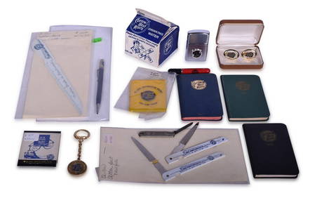
Fifteen Cotton Belt Route Advertising Items - Lighters, Cufflinks, Water Box, Pocket Knife, and MoreRail & Road Auctions4.6(165)See Sold PriceMar 08, 2024
[ARCTIC]. BOWEN, Emanuel. A New & Accurate Map of the North...Potter & Potter Auctions4.6(545)See Sold PriceMar 07, 2024
Vintage Stombecker Best Friend of Charleston Train Kit - Brand New Old Stock.Westside Traders Emporium4.5(34)See Sold PriceFeb 27, 2024
1750 Bowen Map of Bermuda and St. Kitts -- A New & Accurate Map of Bermudas or Sommer's Islands...Jasper524.5(9.9k)See Sold PriceFeb 27, 2024
WEST AFRICA. European colonies; Mauritius; Ascension; St Helena 1907 old mapJasper524.5(9.9k)See Sold PriceFeb 28, 2024
AFRICAN ISLANDS.Mauritius Madagascar Madeira Canaries St Helena 1897 old mapJasper524.5(9.9k)See Sold PriceFeb 28, 2024
TOMMY HENRICH SIGNED 8x10 PHOTO NEW YORK YANKEES OLD RELIABLE NY SPORTS SHOW COAGolden Air Auctions4.3(265)See Sold PriceFeb 27, 2024


![[ARCTIC]. BOWEN, Emanuel. A New & Accurate Map of the North... (1 of 1)](https://p1.liveauctioneers.com/928/318880/171360917_1_x.jpg?height=282&quality=70&version=1707501302)


